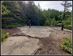
3-17-21
Power
to my street was being cut off for a day. Without power I had no
Internet and no way to do my job. Time to take an unexpected day off.
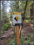
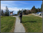
Gary was free and suggested going north to Oyster Dome. I have hike to
Oyster Dome many times but never via the Chuckanut Drive trailhead.
Very little parking and way too many people. Especially not during a
pandemic when I have been avoiding crowds on the trail. But on a
Wednesday instead of a weekend? I was on board. A big loop from this
side would give me a chance to hike several trails I had never been on.
We still had to deal with mid week traffic so I was on the road at 6:54
am. Gary had to come from farther south and go through Bellevue. He
left nearly a half hour earlier. When I exited I-5 I saw a car that
looked like Gary's right behind me on the off ramp. Yes, it was Gary.
Talk about good timing. Actually he had seen me way back in Everett. We
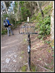
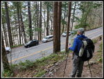
arrived at the trailhead at 8:08 am. There was only one other car
parked along the side of the road. The 130' elevation start is one of
the lowest I can recall.
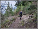
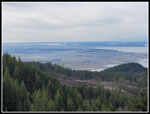
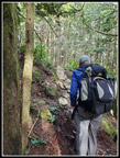
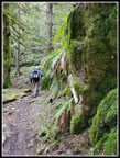
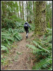
We were on our way by 8:17 am. The slope is extremely steep. The trail switches back and forth and we were quickly up several hundred feet and could see our cars right below us. We set a steady pace climbing higher. The first junction is at 1.4 miles. Right goes over to the Samish Overlook. This would be our route coming down. We continued up and the grade began to ease a little. At one spot we passed a bench with views out to the saltwater. We passed one group coming down then another. With only one car down on Chuckanut it is likely we were already seeing folks going to Oyster Dome via the Samish Overlook Trailhead. We saw a few more people hiking down already. The next junction is at the 3 mile mark. This one I have passed may times coming from the eastern trailheads. Now just .30 more miles to the Oyster Dome viewpoint.
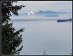
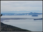
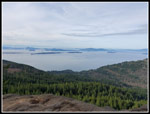
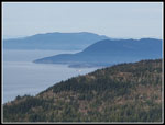
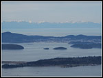
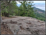
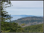
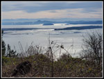
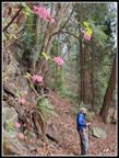
We arrived to find one couple at the viewpoint. This spot is very busy on a weekend. It is rare for me to be up there alone. The sky was mostly white but the cloud layer was very thin. Not great contrast for photos but not terrible either. We could see out to the islands and over to Anacortes. The Olympic Mountains were right behind. The couple left and we were alone. We spent 24 minutes here then more folks started arriving. Time to go over to the highest points above the viewpoint. We then dropped to the lower viewpoint for a look to the south then headed down. More folks were coming up. This thinned greatly when we passed the trail we had come up. The route over to Lily Lake is a gentle climb. At the big skunk cabbage spot there were many leaves now above the water level. One looked to be yellow. In a week or two the color should really start to stand out.
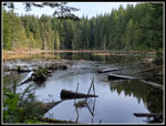
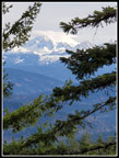
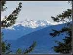
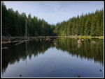
At the next junction we turned left for the short hike to Lily Lake. We went to the camping area near the outlet for a look up the lake. Next we headed along the shore then up through the main camping area. I saw the new signs showing the numbered sites. The trail climbs up to the top of North Butte. I was relieved to find nobody on top. The short scramble up the rock to the top provides an area where it is hard to sit many folks while providing social distancing. We were now out of the forest and had a little sunshine through the clouds. It was now 11:00 am. Time for lunch. We were higher than Oyster Dome but had a more limit view west. Still it's pretty nice. This break lasted for 39 minutes. Lots of hiking and lots of sitting enjoying views this day. When we left we headed over to the narrow viewpoint to the east. I could see Mt. Baker through a few branches. It was very white and it had a lenticular cloud over the top. There was a better view of the Twin Sisters. Very snowy with sun shining on them.
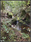
Next to North Butte is a forested bump that is higher. It is completely forested. I slogged up it in 2010. A benchmark named the summit "Lily" and it was dated 1941. Gary and I headed up. We found an unofficial mountain bike trail going almost right over the top. We looked for the benchmarks but found nothing. We headed down to the trail and followed it down. At the first junction we went left and descended to Lizard Lake. Higher up there was some snow off the trail. There is not much left on Blanchard Hill. Down at Lizard Lake we went over to the camping area. Nice views down the lake. There was sunshine but we were under trees and had none. More skunk cabbage coming up here but only one bit of yellow. A week or two and these will also be in bloom.
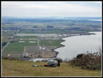
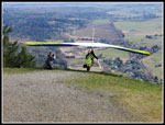
Our break was short here and we quickly hike to the junction with the Alternate Incline Trail and the Pacific Northwest Trail (PNT). We turned right and followed the PNT. It is a wide old railroad grade along here. I thought we were going down Max's Short Cut Trail near Lily Lake. but at the next junction Gary suggested going down the Lily Lizard Trail. We continued to see a few folks on our way down. It was never very crowded. We even saw one mountain biker. Part way down we turned onto the Lily Max Connector Trail which took us over to the junction of Max's Shortcut and the Larry Reed Trail. I had been down this trail before. I had not been on the Larry Reed Trail. This led us down to the Samish Overlook. Another first for me. We arrived at the overlook at 2:06 pm. We proceeded down to the parasailor take off spot. One guy was there with his parasailor.
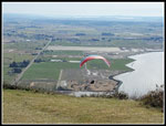
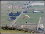
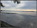
It was a little sunny now and we had a great view south to the Skagit Flats. It was very hazy so photos were okay but not the best. We finished our food and just enjoyed the views and the sunshine. This sure beat sitting in my house in Seattle with no power or heat all day long. We did not want to get back to Seattle at the peak of the commute so we just lazed away the afternoon. The parasailor took off and in the cool air quickly lost altitude. Within about 5 minutes he was 1200' lower and landed right next to his vehicle right off Chuckanut Drive. We saw a train go by. Another guy arrived with an old style hang glider. He took a long time reassembling it then he took off for a 5 minute descent. He landed right where the fist guy did. It was 3:53 pm when we packed up and started down. The parking lot was almost full. Lots of folks were on the trail to Oyster Dome and some were just enjoying the views.
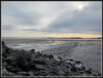
In .40 miles we closed our loop and were back on the trail we took on the way up. The last 1.4 miles went pretty quickly. We saw more folks on these final legs than I expected. We arrived back at the cars at 4:47 pm. We had noticed a trail descending from right where we parked. Gary joked that we should follow it. And we did. It dropped down to the railroad tracks near sea level. We crossed the tracks. The tide was way out. Nice views from the rocky beach. We soon headed back up to the cars. It was now 5:20 pm.
With the side routes we took the day grew to 12 miles with about 2900' of elevation gain. More than we expected. It was a long day as I left the house at 6:54 am and returned home at 6:45 pm. The hike was a lot of fun. A Dome, A Butte, two lakes, and and Overlook. We went from sea level to 2300'. We spent a lot of time just sitting and enjoying the views at Oyster Dome, North Butte, and Famish Overlook. I don't take many days off work but this one was really great.
Click on thumbnails to get
larger pictures.
Trips - 2021
Home
We were on our way by 8:17 am. The slope is extremely steep. The trail switches back and forth and we were quickly up several hundred feet and could see our cars right below us. We set a steady pace climbing higher. The first junction is at 1.4 miles. Right goes over to the Samish Overlook. This would be our route coming down. We continued up and the grade began to ease a little. At one spot we passed a bench with views out to the saltwater. We passed one group coming down then another. With only one car down on Chuckanut it is likely we were already seeing folks going to Oyster Dome via the Samish Overlook Trailhead. We saw a few more people hiking down already. The next junction is at the 3 mile mark. This one I have passed may times coming from the eastern trailheads. Now just .30 more miles to the Oyster Dome viewpoint.
We arrived to find one couple at the viewpoint. This spot is very busy on a weekend. It is rare for me to be up there alone. The sky was mostly white but the cloud layer was very thin. Not great contrast for photos but not terrible either. We could see out to the islands and over to Anacortes. The Olympic Mountains were right behind. The couple left and we were alone. We spent 24 minutes here then more folks started arriving. Time to go over to the highest points above the viewpoint. We then dropped to the lower viewpoint for a look to the south then headed down. More folks were coming up. This thinned greatly when we passed the trail we had come up. The route over to Lily Lake is a gentle climb. At the big skunk cabbage spot there were many leaves now above the water level. One looked to be yellow. In a week or two the color should really start to stand out.
At the next junction we turned left for the short hike to Lily Lake. We went to the camping area near the outlet for a look up the lake. Next we headed along the shore then up through the main camping area. I saw the new signs showing the numbered sites. The trail climbs up to the top of North Butte. I was relieved to find nobody on top. The short scramble up the rock to the top provides an area where it is hard to sit many folks while providing social distancing. We were now out of the forest and had a little sunshine through the clouds. It was now 11:00 am. Time for lunch. We were higher than Oyster Dome but had a more limit view west. Still it's pretty nice. This break lasted for 39 minutes. Lots of hiking and lots of sitting enjoying views this day. When we left we headed over to the narrow viewpoint to the east. I could see Mt. Baker through a few branches. It was very white and it had a lenticular cloud over the top. There was a better view of the Twin Sisters. Very snowy with sun shining on them.
Next to North Butte is a forested bump that is higher. It is completely forested. I slogged up it in 2010. A benchmark named the summit "Lily" and it was dated 1941. Gary and I headed up. We found an unofficial mountain bike trail going almost right over the top. We looked for the benchmarks but found nothing. We headed down to the trail and followed it down. At the first junction we went left and descended to Lizard Lake. Higher up there was some snow off the trail. There is not much left on Blanchard Hill. Down at Lizard Lake we went over to the camping area. Nice views down the lake. There was sunshine but we were under trees and had none. More skunk cabbage coming up here but only one bit of yellow. A week or two and these will also be in bloom.
Our break was short here and we quickly hike to the junction with the Alternate Incline Trail and the Pacific Northwest Trail (PNT). We turned right and followed the PNT. It is a wide old railroad grade along here. I thought we were going down Max's Short Cut Trail near Lily Lake. but at the next junction Gary suggested going down the Lily Lizard Trail. We continued to see a few folks on our way down. It was never very crowded. We even saw one mountain biker. Part way down we turned onto the Lily Max Connector Trail which took us over to the junction of Max's Shortcut and the Larry Reed Trail. I had been down this trail before. I had not been on the Larry Reed Trail. This led us down to the Samish Overlook. Another first for me. We arrived at the overlook at 2:06 pm. We proceeded down to the parasailor take off spot. One guy was there with his parasailor.
It was a little sunny now and we had a great view south to the Skagit Flats. It was very hazy so photos were okay but not the best. We finished our food and just enjoyed the views and the sunshine. This sure beat sitting in my house in Seattle with no power or heat all day long. We did not want to get back to Seattle at the peak of the commute so we just lazed away the afternoon. The parasailor took off and in the cool air quickly lost altitude. Within about 5 minutes he was 1200' lower and landed right next to his vehicle right off Chuckanut Drive. We saw a train go by. Another guy arrived with an old style hang glider. He took a long time reassembling it then he took off for a 5 minute descent. He landed right where the fist guy did. It was 3:53 pm when we packed up and started down. The parking lot was almost full. Lots of folks were on the trail to Oyster Dome and some were just enjoying the views.
In .40 miles we closed our loop and were back on the trail we took on the way up. The last 1.4 miles went pretty quickly. We saw more folks on these final legs than I expected. We arrived back at the cars at 4:47 pm. We had noticed a trail descending from right where we parked. Gary joked that we should follow it. And we did. It dropped down to the railroad tracks near sea level. We crossed the tracks. The tide was way out. Nice views from the rocky beach. We soon headed back up to the cars. It was now 5:20 pm.
With the side routes we took the day grew to 12 miles with about 2900' of elevation gain. More than we expected. It was a long day as I left the house at 6:54 am and returned home at 6:45 pm. The hike was a lot of fun. A Dome, A Butte, two lakes, and and Overlook. We went from sea level to 2300'. We spent a lot of time just sitting and enjoying the views at Oyster Dome, North Butte, and Famish Overlook. I don't take many days off work but this one was really great.
 Bench Along Trail |
 View From Bench |
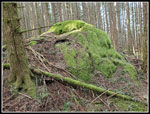
 Big Rock |
 View From Oyster Dome |
 View To The West |
 Helicopter |
 Anacortes |
 Solitude At Oyster Dome |
 Lower Viewpoint |
 View South |
 Gurgling Creek |
 Lily Lake |
 Falling Hikers |
 North Butte View |
 Mt. Baker |
 Twin Sisters |
 On Bike Trail |
 Mossy Rock |
 Mossy Wall |
 Lizard Lake |
 Lily-Lizard Trail |
 Samish Overlook |
 Parasailor |
 There He Goes |
 Hang Glider |
 Time To Leave |
 Signboard |
 Shimmering Water |
 PNT Sign |
 Unusual Stump |
 Chuckanut Trailhead |
 Tide Is Out |
 Wildflowers |
 Sea Level View |
 Shells & Golf Balls |
 Leaving Beach |
Trips - 2021
Home