7-03-21
I
just heard that the summits of
West Tiger 1, 2, and 3 would close on July 6 until the they had all
been logged. I wanted to get one last hike to the peaks and take photos
showing the summit forests. This was the first day of a three day
Fourth Of July weekend. I arrived at High Point at 7:15 am to find only
two other cars. It looked like folks were out for the holidays and not
on Tiger Mountain. I saw two people on the hike up Tiger 1. I took the
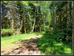
Lingering Trail to add a quarter mile or so. The first thing I noticed
was that it was humid. It was not that warm but I was quickly covered
in sweat. The problem lessened as I gained elevation.
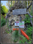
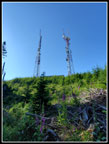
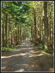
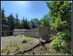
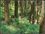
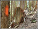
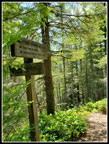
On the TMT before Ruth's Cove I noticed dozens of Indian pipe saprophytes just raising out of the ground. They have no chlorophyll and so no green coloring. They are entirely white. I had only seen them one time on Tiger Mountain. Checking after the hike I was surprised to find that it was just last year and in this same spot. I stopped for photos and continued on. It the point the new section of the TMT reaches the railroad grade I turned left and headed over to the Preston Trail. I noticed that the wild ginger were still blooming but none of the wild looking flowers were open. I guess they only open later in the day when the sun is shining. At the top of the Preston Trail I saw the first sign of the day announcing the summit logging. A right turn towards the Hikers Hut will be closed. A left turn on the bootleg trail will remain open. I turned left on the bootleg. Thee first part is brushy with lots of blooming foxglove. The dew rubbed off on me as I passed. I then went uphill to the lower east side towers. The new fans that blow icy cold air on passersby did not feel very cold this day.
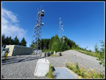
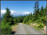
Up the road to the next towers and time for a lunch break. It was more like breakfast time. It was all sunshine and blue sky overhead and it was now pleasantly warm in shorts and short sleeves. Views out to the mountains were cloudy and hazy. I could see a little of Mt. Si but not much else. So much for the best viewpoint on Tiger summits. The logging will close the trails for months or longer. It will also reopen the views that existed when I first started hiking on Tiger in 1983. It will be an interesting trade off. As of now there are some views including Mt. Rainier from the west end of Tiger 1 at the Hikers Hut. There are currently no views at all from Tiger 2 and 1. Even ten years ago there were views from both.
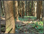
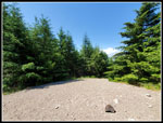
I spent over half an hour sitting in the sun and relaxing. I still had seen only two people. My rest spot is right where the road reenters forest. A decade or so ago the upper mountain was clear cut east of here. I expect the rest of the summits will be done the same. The north side and west side above Issaquah of West Tiger Mountain is now in the West Tiger Mountain Natural Resource Conservation area. This part will never be logged. A narrow area of private land encompasses the three summits and the ridge that connects them. It includes the towers atop Tiger 2 and 3 plus a short distance below the ridge. That is what will be logged. The logged area on the east end of Tiger 1 goes down to about where the Preston Trail meets the Bootleg. I headed into the forest for the short hike to the actual summit. I met a hiker there who had come up the Poo Top and ended up near the towers and did not see the trail down tot he Bypass Trail. I sent her on her way to the Hikers Hut. I took photos of the summit here to compare to when it is clear cut.
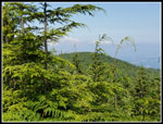
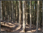
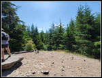
Down the trail to the Bypass and on the the Hikers Hut. fro the Bypass I could see the line of red tape that marked the boundary of private property and so the logging. It is not that far below the trail. I arrived to find...nobody. A bench from the Hut has been dragged outside for more seating. I could now see the top of Mt. Rainier but that was it. A couple came up and we got into a discussion of the logging and the history of Tiger Mountain. A good discussion. When another hiker arrived the couple set out to finish a route similar to mine but in the opposite direction. I headed down the road. The gate at the bottom blocking the road up Tiger 2 was open for one of the few times I can recall. Getting ready for logging. At one spot on the road the boundary comes right up to the road at a 90 degree angle. They will have to leave a few trees right up tot he road. I climbed up to Tiger 2 and found hikers on the summit. I took one photo and went on. I already have many photos of the top of Tiger 2. I dropped down the Cable Line Trail then climbed up to the summit of Tiger 3. Several groups were talking to each other and I just stayed long enough to get photos of the trees blocking all views and a quick 360 degree video.
I dropped back down to the TMT and turned left on the route around Tiger 2. Lots more red tape and pained trees marking the property line. In one spot the trail is right on the line. I reached Tom's Crossing and headed down the ridge. I have a photo from the mid 1980s where Mt. Baker was visible from there. So was the top of Tiger 3. There is still a view out to Mt. Si but trees have grown to block all other views. My photo work done I hiked on down the TMT. I saw a few more folks along the way but not many. I took the High Point Trail down from the TMT. My photos, breaks, and general slow pace had me out much longer than I had expected. I reached the car at 1:50 pm. Over six hours to hike 9 miles is a long time on Tiger. I hope the logging can be finished by the end of the fall and our winter headlamp hikes can continue on Tiger. The area to log is not that large. Roads are already in place. We shall see.
Click on thumbnails to get
larger pictures.
Trips - 2021
Home
On the TMT before Ruth's Cove I noticed dozens of Indian pipe saprophytes just raising out of the ground. They have no chlorophyll and so no green coloring. They are entirely white. I had only seen them one time on Tiger Mountain. Checking after the hike I was surprised to find that it was just last year and in this same spot. I stopped for photos and continued on. It the point the new section of the TMT reaches the railroad grade I turned left and headed over to the Preston Trail. I noticed that the wild ginger were still blooming but none of the wild looking flowers were open. I guess they only open later in the day when the sun is shining. At the top of the Preston Trail I saw the first sign of the day announcing the summit logging. A right turn towards the Hikers Hut will be closed. A left turn on the bootleg trail will remain open. I turned left on the bootleg. Thee first part is brushy with lots of blooming foxglove. The dew rubbed off on me as I passed. I then went uphill to the lower east side towers. The new fans that blow icy cold air on passersby did not feel very cold this day.
Up the road to the next towers and time for a lunch break. It was more like breakfast time. It was all sunshine and blue sky overhead and it was now pleasantly warm in shorts and short sleeves. Views out to the mountains were cloudy and hazy. I could see a little of Mt. Si but not much else. So much for the best viewpoint on Tiger summits. The logging will close the trails for months or longer. It will also reopen the views that existed when I first started hiking on Tiger in 1983. It will be an interesting trade off. As of now there are some views including Mt. Rainier from the west end of Tiger 1 at the Hikers Hut. There are currently no views at all from Tiger 2 and 1. Even ten years ago there were views from both.
I spent over half an hour sitting in the sun and relaxing. I still had seen only two people. My rest spot is right where the road reenters forest. A decade or so ago the upper mountain was clear cut east of here. I expect the rest of the summits will be done the same. The north side and west side above Issaquah of West Tiger Mountain is now in the West Tiger Mountain Natural Resource Conservation area. This part will never be logged. A narrow area of private land encompasses the three summits and the ridge that connects them. It includes the towers atop Tiger 2 and 3 plus a short distance below the ridge. That is what will be logged. The logged area on the east end of Tiger 1 goes down to about where the Preston Trail meets the Bootleg. I headed into the forest for the short hike to the actual summit. I met a hiker there who had come up the Poo Top and ended up near the towers and did not see the trail down tot he Bypass Trail. I sent her on her way to the Hikers Hut. I took photos of the summit here to compare to when it is clear cut.
Down the trail to the Bypass and on the the Hikers Hut. fro the Bypass I could see the line of red tape that marked the boundary of private property and so the logging. It is not that far below the trail. I arrived to find...nobody. A bench from the Hut has been dragged outside for more seating. I could now see the top of Mt. Rainier but that was it. A couple came up and we got into a discussion of the logging and the history of Tiger Mountain. A good discussion. When another hiker arrived the couple set out to finish a route similar to mine but in the opposite direction. I headed down the road. The gate at the bottom blocking the road up Tiger 2 was open for one of the few times I can recall. Getting ready for logging. At one spot on the road the boundary comes right up to the road at a 90 degree angle. They will have to leave a few trees right up tot he road. I climbed up to Tiger 2 and found hikers on the summit. I took one photo and went on. I already have many photos of the top of Tiger 2. I dropped down the Cable Line Trail then climbed up to the summit of Tiger 3. Several groups were talking to each other and I just stayed long enough to get photos of the trees blocking all views and a quick 360 degree video.
I dropped back down to the TMT and turned left on the route around Tiger 2. Lots more red tape and pained trees marking the property line. In one spot the trail is right on the line. I reached Tom's Crossing and headed down the ridge. I have a photo from the mid 1980s where Mt. Baker was visible from there. So was the top of Tiger 3. There is still a view out to Mt. Si but trees have grown to block all other views. My photo work done I hiked on down the TMT. I saw a few more folks along the way but not many. I took the High Point Trail down from the TMT. My photos, breaks, and general slow pace had me out much longer than I had expected. I reached the car at 1:50 pm. Over six hours to hike 9 miles is a long time on Tiger. I hope the logging can be finished by the end of the fall and our winter headlamp hikes can continue on Tiger. The area to log is not that large. Roads are already in place. We shall see.
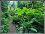 Healthy Devil's Club |
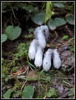 Indian Pipe |
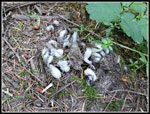 More Indian Pipe |
 Unknown Flower |
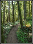 Morning Light |
 Logging Notice |
 Earlier Clear Cut |
 Road To Summit |
 Tiger 2 Summit |
 Forested Road |
 Logging Markers |
 Dense Trees |
 Hikers Hut Views |
 T1 T2 Saddle |
 Tiger 2 |
 Tiger 3 Views |
 Tiger 2 From Tiger 3 |
 TMT Logging Boundary |
 Boundary On TMT |
 Tom's Crossing |
 Sign Overgrown |
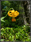 Tiger Lily |
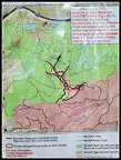 Trail Closures |
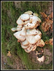 Neat Fungus |
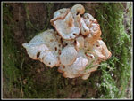 Neat Fungus II |
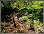 Ruth's Cove |
Trips - 2021
Home