12-26-22
Gary was free for a hike the day after Christmas. We had not hiked
together since he injured his hamstring in August. I was looking
forward to the trip. The year is rapidly coming to the end and I was
now so close to my second 1000 mile hiking year. With 15 miles to go I
needed to get out at least once before my annual New Year's Eve hike on
Tiger Mountain. The past week has had some terrible weather. Some snow
followed by very low temperatures and then an evening of frozen rain.
Seattle almost never sees frozen rain. I woke up on Thursday to ice
covering everything. Happy Birthday me! I never left my house. My steps
were solid ice. My car had ice covering all of it. The doors were
connected by ice. They would not be opening. No problem, I would not
have left my driveway under any circumstances. By Christmas, on
Saturday, it was raining and 50 degrees. Sunday morning, I woke up to
driving rain and very high winds. Not hiking weather. I called Gary at
7:15 am and we checked the weather sites. It looked like there should
be a break in the rain from about 10:00 am to 1:00 pm. I had to get in
a hike. We planned to meet at Red Town for a quick hike on Cougar
Mountain. We planned to hike west down Coal Creek since the rain was
coming out of the west and we "should" have it end earlier for us this
way. It actually worked.
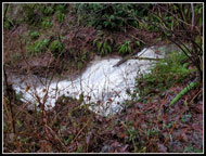
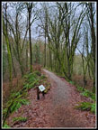
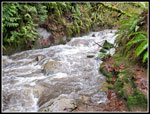
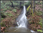
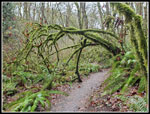
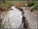
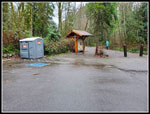
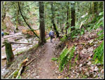
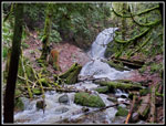
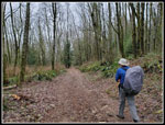
We met at Red Town at 10:00 am. My drive was windy but dry until Coal Creek. The rain was brief and we met to find no rain and no wind. Both were supposed to return for the afternoon so we quickly got started. I had not done the Coal Creek Trail in probably a decade until this fall. This would be my third time on it in the past couple months. There are two waterfalls and with all the recent rain I hoped they would be raging. We crossed the road and descended into the canyon of Coal Creek. The first waterfall comes up pretty quick. Gary has hiked most of Cougar Mountain but had not been on this trail. When I was here a few weeks earlier there was a good flow over the waterfall. This day there was twice as much. We stopped for photos. The second waterfall was also raging. The top is very narrow but the water lands on a rock slab and cascades down to Coal Creek.
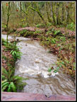
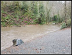
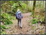
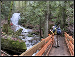
As we headed on, it began to rain. It was quickly hard enough to pull out our umbrellas. Within a few minutes it eased up and that was the end of the rain for this trip. We took the Primrose Trail in both directions. It is closer to the creek and with the high water the little creek was not so little. We saw a few groups but the trail was not very busy. We reached the Coal Creek Trailhead at 11:21 am. We had hiked 2.86 miles. I showed Gary the route under Coal Creek Way. Part way under the road the walkway was underwater. I tried to continue but the several inch deep water quickly became much deeper. Time to turn around. We hiked back up the trail. We reached Red Town at 12:40 pm. We had our lunch at the trailhead. It was 1:58 when we headed up the Military Road.
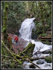
We had almost 6 miles done but we wanted to get more and some elevation gain. Though we were near the time the rain was supposed to start, the sky looked fairly light white. Not like dark rain clouds. We headed up the trail. It is one mile to the Sky Country Trailhead. There was no rain yet and we continued to the Cave Hole Road. Now we had several choices. A right turn would take us to Coal Creek Falls the shortest way. A left turn provided more options. We could go up to Anti-Aircraft Peak. That would make for almost a 12 mile day. It would be pushing our dry no wind luck too. We chose to go left up to Fred's Railroad. We turned right and continued to the Quarry Trail. Descending the Quarry Trail brought us to the trail that descends to Coal Creek Falls.
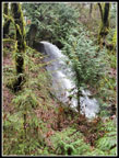
I expected to see at least several groups at the falls. I was not disappointed. There were three or four groups there and some leaving and more arriving. The falls were flowing very strong. This was our third waterfall of the day and the most impressive one. We stopped for photos and videos of the falls. Before long, it was time to head down. The trail back to the Cave Hole Road has a lot more uphill than downhill. That added to a below average elevation gain hike. At the Cave Hole Road we turned left for the short hike back to the trailhead. We arrived at 2:54 pm. Our start was much later than usual but it did allow us to miss the heavy rain in the morning and the rain that started after our return. The wind was also calm on our hike but howled for most of the day. We were very fortunate.
For the day we hiked 10.15 miles with 1400' of elevation gain. We both ran a gps track on this trip. Multiple gps units always provide different distances over 10 miles. This day was weird. Each time we checked our tracks they were at exactly the same distance. The differences were never more than 2/100 of a mile. At the end we showed exactly the same distance. I doubt I will ever see that happen again. The upside of all the rain we have been having is that the creek and the waterfalls were really howling. It was the best time to see Coal Creek. All three waterfalls looked much better than they usually do. The 10 miles we covered brought me up to 995 miles on the year. Barring an injury or another freak freezing rainstorm, I will have my second 1000 mile hiking season in the 40 years I have been recording my miles and elevation gain. This trip brought me over 240,000' of elevation gain. This is only the fifth time I have reached that level. It means my monthly average was over 20,000' per month. This has turned out to be one of the best hiking years I have had by the numbers. Lastly, this is my 59th trip report of the year. That breaks by previous high of 58 trip reports in one year.
Click on thumbnails to get
larger pictures.
Trips - 2022
Home
We met at Red Town at 10:00 am. My drive was windy but dry until Coal Creek. The rain was brief and we met to find no rain and no wind. Both were supposed to return for the afternoon so we quickly got started. I had not done the Coal Creek Trail in probably a decade until this fall. This would be my third time on it in the past couple months. There are two waterfalls and with all the recent rain I hoped they would be raging. We crossed the road and descended into the canyon of Coal Creek. The first waterfall comes up pretty quick. Gary has hiked most of Cougar Mountain but had not been on this trail. When I was here a few weeks earlier there was a good flow over the waterfall. This day there was twice as much. We stopped for photos. The second waterfall was also raging. The top is very narrow but the water lands on a rock slab and cascades down to Coal Creek.
As we headed on, it began to rain. It was quickly hard enough to pull out our umbrellas. Within a few minutes it eased up and that was the end of the rain for this trip. We took the Primrose Trail in both directions. It is closer to the creek and with the high water the little creek was not so little. We saw a few groups but the trail was not very busy. We reached the Coal Creek Trailhead at 11:21 am. We had hiked 2.86 miles. I showed Gary the route under Coal Creek Way. Part way under the road the walkway was underwater. I tried to continue but the several inch deep water quickly became much deeper. Time to turn around. We hiked back up the trail. We reached Red Town at 12:40 pm. We had our lunch at the trailhead. It was 1:58 when we headed up the Military Road.
We had almost 6 miles done but we wanted to get more and some elevation gain. Though we were near the time the rain was supposed to start, the sky looked fairly light white. Not like dark rain clouds. We headed up the trail. It is one mile to the Sky Country Trailhead. There was no rain yet and we continued to the Cave Hole Road. Now we had several choices. A right turn would take us to Coal Creek Falls the shortest way. A left turn provided more options. We could go up to Anti-Aircraft Peak. That would make for almost a 12 mile day. It would be pushing our dry no wind luck too. We chose to go left up to Fred's Railroad. We turned right and continued to the Quarry Trail. Descending the Quarry Trail brought us to the trail that descends to Coal Creek Falls.
I expected to see at least several groups at the falls. I was not disappointed. There were three or four groups there and some leaving and more arriving. The falls were flowing very strong. This was our third waterfall of the day and the most impressive one. We stopped for photos and videos of the falls. Before long, it was time to head down. The trail back to the Cave Hole Road has a lot more uphill than downhill. That added to a below average elevation gain hike. At the Cave Hole Road we turned left for the short hike back to the trailhead. We arrived at 2:54 pm. Our start was much later than usual but it did allow us to miss the heavy rain in the morning and the rain that started after our return. The wind was also calm on our hike but howled for most of the day. We were very fortunate.
For the day we hiked 10.15 miles with 1400' of elevation gain. We both ran a gps track on this trip. Multiple gps units always provide different distances over 10 miles. This day was weird. Each time we checked our tracks they were at exactly the same distance. The differences were never more than 2/100 of a mile. At the end we showed exactly the same distance. I doubt I will ever see that happen again. The upside of all the rain we have been having is that the creek and the waterfalls were really howling. It was the best time to see Coal Creek. All three waterfalls looked much better than they usually do. The 10 miles we covered brought me up to 995 miles on the year. Barring an injury or another freak freezing rainstorm, I will have my second 1000 mile hiking season in the 40 years I have been recording my miles and elevation gain. This trip brought me over 240,000' of elevation gain. This is only the fifth time I have reached that level. It means my monthly average was over 20,000' per month. This has turned out to be one of the best hiking years I have had by the numbers. Lastly, this is my 59th trip report of the year. That breaks by previous high of 58 trip reports in one year.
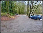 Red Town Trailhead |
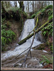 First Waterfall |
 Roaring Cascade |
 Mossy Trees |
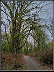
 Old Railroad Grade |
 At Creek Level |
 Second Waterfall |
 Side View Of Falls |
 Very Mossy Arbor |
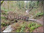
 Bridge Over Coal Creek |
 Undercut Trail |
 Near The West End |
 Coal Creek Trailhead |
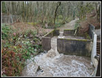 Fish Ladder |
 Bridge Over Side Creek |
 Gary On Quarry Trail |
 Near Coal Creek Falls |
 Coal Creek Falls |
 Coal Creek Falls Again |
 CC Falls & Me |
 On Cave Hole Road |
Trips - 2022
Home