09-04-22
Last
weekend I did only my second 4000; gain hike of the year. Time for
another. This time I did not want another 225 mile round trip drive. I
settled on Mt. Teneriffe, near North Bend. They forecast was for a
sunny morning turning to partial overcast around noon. I needed an
early start for the best views. I was on the road at 6:30 am and in the
parking lot at 7:13 am. Surprisingly, I was the second car in the lot.
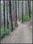
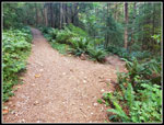
I grabbed my pack and was on my way at 7:17 am. It was clear but a bit
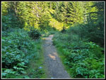
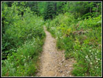
cool. Just what I was hoping to see. Half a mile up the new trail to
the old road/trail. On past the Teneriffe Falls turnoff and fairly
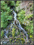
flat. The creeks were still running. I needed to rock hop two. The
waterfall had some water but not a lot. Then the climbing began. I
reached the first trail coming over from the Mt. Si Trail and one hiker
merged into my trail. She stopped and I passed here. Two minutes later
she passed me and was quickly out of sight.
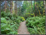
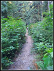
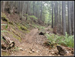
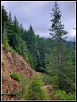
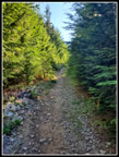
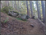
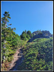
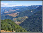
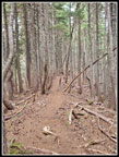
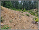
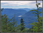
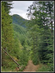
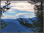
Once the climbing begins it is nearly continuous. I set a steady pace and worked my way up the trail. The old road is narrowing with some brush in many places. Some spots have little ground cover and are still pretty wide. Some of the tread is smooth and some is pretty rocky. It is not close to as bad as the Mt. Washington lower trail but rockier than most built trails in the area. It was a bit humid. As the temperature rose I started to sweat more. I took a food and water bread at the spot with a view of Mt. Rainier, Rattlesnake Lake, and the summit of Mt. Teneriffe. Rainier and Teneriffe were hidden by low clouds. Now I was heading away from Teneriffe and towards Mt. Si. The old road takes a long way to get to the top. Soon I reached the one flat spot and the creeks here were still running. That was unusual for early September.
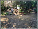
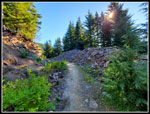
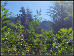
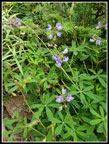
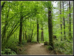
Climbing resumed and at 4.2 miles I passed the turnoff for Mt. Si. More steep ascending and then the trail flattens once again. I passed a runner coming down from Mt. Teneriffe. Two people seen in about five miles. Not too bad. There were still some late season wildflowers blooming. A couple penstemon, Many pearly everlasting, some foxglove, and a few fireweed. The trail drops a little and then climbs up to the road end. The Mt. Si junction and the end of the old road both have maps on posts showing the current location. The last part was partly in sunshine and now I went back into forest. It was cooler and most of it is on newer trail. I was able to pick up the pace a bit since the tread was so much better than the rocky old road. I climbed to the high point on the ridge and then dropped down to the saddle. As I began the last climb under the summit of Mt. Teneriffe, two runners zipped on past me. That made for 4 people seen on the 6.5 miles of the ascent.
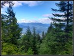
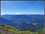
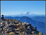
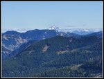
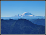
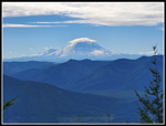
I had looked at recent trip reports on this site the night before. I noticed that my last time was 3:00 exactly on the way up. Coincidentally, my time the trip before was also exactly 3:00. I checked my phone clock at the viewpoint right at the base of the final scramble and I had taken 2:56. I sped up the last bit and reached the top at 10:16 am. I took 2:59 on my way up. It is almost impossible to believe that three trips over just four years could have taken within one minute of each other. I guess I'm not slowing down as much as I feared. There was one person on the summit. It was the women who zoomed by early in the hike. Still only four different people seen on the way up. The views were really great. There were no clouds to be seen by Mt. Rainier. Mt. Baker was in the clouds to the north. That was about it. Everything else was pretty clear. I could even see Glacier Peak. Soon the lone woman headed down leaving alone on the summit.
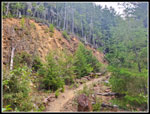
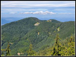
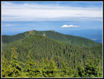
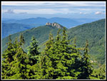
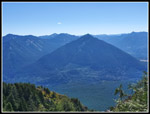
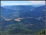
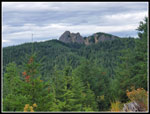
I could imagine the dozens if not a hundred people on or near the summit of Mailbox Peak across the valley. Rattlesnake Ledge was equally crowded as always on a sunny weekend day. Rattlesnake Lake is usually very low this time of year but looked to be full of water. The recent logging on West Tiger Mountain was clearly visible. Seattle and Bellevue were seen but it was a bit hazy to the west. I was looking down on the Haystack summit of Mt. Si. I'm sure that trail was packed this day. The cars immediately ahead and behind me turned into that lot. I could see Blowdown Mountain. That forested high point near Si is a peak I first ascended last fall. Dixie Peak was down the ridge a little farther. To the east, Green Mountain is close to Teneriffe. Another hiker soon scrambled up. He had moved here from Texas a decade earlier. We talked hiking for quite a while. He had also been up here when the summit was buried with snow.
Two more women came up later. All five of us packed up and started down at about 11:23 am. I had 1:07 on top. There was a light cool wind on the summit but I managed well with just a wet short sleeve shirt. When I left it was a dry shirt. I stopped for more photos at the base of the scramble where the trail down Kamikaze/Teneriffe Ridge begins. Descending the trail went fast. I then had the climb back up to the false summit and then the nice trail down to the road end. I caught up with the two women there. I previously decided to take a look for the boot path than goes up Dixie Peak. After going a bit off route I found it and went up a short way. I have done Dixie on snowshoes but not on dirt. I'd like to give that a try soon. I went back to the main trail and headed down. I still had 5.5 miles to go and it can seem to take forever.
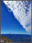
On the way up I looked over my shoulder several times for the spot where your can see the Haystack atop Mt. Si from the road/trail. I never did see it. On the way down I did. Near the same spot was a look over to Mt. Rainier. It now had a lenticular cloud cap forming on top. A signal of a change in the weather. We saw clouds moving east from Seattle on top of Teneriffe. They were now overhead. There were sun breaks but also some shade on the way down. I saw hikers and runners every now and then but there were not a lot of them on the route this day. Down past the Si junction to the flat spot then the steep descent picked up again. I made it down to the last of two trails over to Mt. Si when I caught up with the two women from the summit. The last 1.5 miles dragged on though I was setting a good pace. I arrived back at the trailhead at 2:09 pm. Even with my Dixie Peak exploration I came down in 2:46.
This trip turned out very well. With an early start, I saw few people on the way up and arrived before clouds came overhead. Views were very good. It was cool on top but not cold. I had over an hour on the summit. The descent was not crowded either. The parking lot was a little more than half full when I returned. It was nice to get in 4400' ascents two weekends in a row. It did warm up to 76 degrees at the finish but it was comfortable on the forested trail. For the day I hiked 13 miles with 4400' of elevation gain.
Click on thumbnails to get
larger pictures.
Trips - 2022
Home
Once the climbing begins it is nearly continuous. I set a steady pace and worked my way up the trail. The old road is narrowing with some brush in many places. Some spots have little ground cover and are still pretty wide. Some of the tread is smooth and some is pretty rocky. It is not close to as bad as the Mt. Washington lower trail but rockier than most built trails in the area. It was a bit humid. As the temperature rose I started to sweat more. I took a food and water bread at the spot with a view of Mt. Rainier, Rattlesnake Lake, and the summit of Mt. Teneriffe. Rainier and Teneriffe were hidden by low clouds. Now I was heading away from Teneriffe and towards Mt. Si. The old road takes a long way to get to the top. Soon I reached the one flat spot and the creeks here were still running. That was unusual for early September.
Climbing resumed and at 4.2 miles I passed the turnoff for Mt. Si. More steep ascending and then the trail flattens once again. I passed a runner coming down from Mt. Teneriffe. Two people seen in about five miles. Not too bad. There were still some late season wildflowers blooming. A couple penstemon, Many pearly everlasting, some foxglove, and a few fireweed. The trail drops a little and then climbs up to the road end. The Mt. Si junction and the end of the old road both have maps on posts showing the current location. The last part was partly in sunshine and now I went back into forest. It was cooler and most of it is on newer trail. I was able to pick up the pace a bit since the tread was so much better than the rocky old road. I climbed to the high point on the ridge and then dropped down to the saddle. As I began the last climb under the summit of Mt. Teneriffe, two runners zipped on past me. That made for 4 people seen on the 6.5 miles of the ascent.
I had looked at recent trip reports on this site the night before. I noticed that my last time was 3:00 exactly on the way up. Coincidentally, my time the trip before was also exactly 3:00. I checked my phone clock at the viewpoint right at the base of the final scramble and I had taken 2:56. I sped up the last bit and reached the top at 10:16 am. I took 2:59 on my way up. It is almost impossible to believe that three trips over just four years could have taken within one minute of each other. I guess I'm not slowing down as much as I feared. There was one person on the summit. It was the women who zoomed by early in the hike. Still only four different people seen on the way up. The views were really great. There were no clouds to be seen by Mt. Rainier. Mt. Baker was in the clouds to the north. That was about it. Everything else was pretty clear. I could even see Glacier Peak. Soon the lone woman headed down leaving alone on the summit.
I could imagine the dozens if not a hundred people on or near the summit of Mailbox Peak across the valley. Rattlesnake Ledge was equally crowded as always on a sunny weekend day. Rattlesnake Lake is usually very low this time of year but looked to be full of water. The recent logging on West Tiger Mountain was clearly visible. Seattle and Bellevue were seen but it was a bit hazy to the west. I was looking down on the Haystack summit of Mt. Si. I'm sure that trail was packed this day. The cars immediately ahead and behind me turned into that lot. I could see Blowdown Mountain. That forested high point near Si is a peak I first ascended last fall. Dixie Peak was down the ridge a little farther. To the east, Green Mountain is close to Teneriffe. Another hiker soon scrambled up. He had moved here from Texas a decade earlier. We talked hiking for quite a while. He had also been up here when the summit was buried with snow.
Two more women came up later. All five of us packed up and started down at about 11:23 am. I had 1:07 on top. There was a light cool wind on the summit but I managed well with just a wet short sleeve shirt. When I left it was a dry shirt. I stopped for more photos at the base of the scramble where the trail down Kamikaze/Teneriffe Ridge begins. Descending the trail went fast. I then had the climb back up to the false summit and then the nice trail down to the road end. I caught up with the two women there. I previously decided to take a look for the boot path than goes up Dixie Peak. After going a bit off route I found it and went up a short way. I have done Dixie on snowshoes but not on dirt. I'd like to give that a try soon. I went back to the main trail and headed down. I still had 5.5 miles to go and it can seem to take forever.
On the way up I looked over my shoulder several times for the spot where your can see the Haystack atop Mt. Si from the road/trail. I never did see it. On the way down I did. Near the same spot was a look over to Mt. Rainier. It now had a lenticular cloud cap forming on top. A signal of a change in the weather. We saw clouds moving east from Seattle on top of Teneriffe. They were now overhead. There were sun breaks but also some shade on the way down. I saw hikers and runners every now and then but there were not a lot of them on the route this day. Down past the Si junction to the flat spot then the steep descent picked up again. I made it down to the last of two trails over to Mt. Si when I caught up with the two women from the summit. The last 1.5 miles dragged on though I was setting a good pace. I arrived back at the trailhead at 2:09 pm. Even with my Dixie Peak exploration I came down in 2:46.
This trip turned out very well. With an early start, I saw few people on the way up and arrived before clouds came overhead. Views were very good. It was cool on top but not cold. I had over an hour on the summit. The descent was not crowded either. The parking lot was a little more than half full when I returned. It was nice to get in 4400' ascents two weekends in a row. It did warm up to 76 degrees at the finish but it was comfortable on the forested trail. For the day I hiked 13 miles with 4400' of elevation gain.
 Starting Out |
 On The Old Road/Trail |
 Waterfall |
 Narrow Trail & Hiker |
 Unsigned Junction |
 Less Brushy |
 Rocky Switchback |
 Viewpoint |
 Summit In Clouds |
 Mt. Si Junction |
 Narrow Trail |
 Blasted Road |
 Meadow |
 Only Summit View |
 From Road To Trail |
 View Below Summit |
 Summit Just Above |
 Rainier from Summit |
 Blowdown Mountain |
 Glacier Peak |
 Clearcuts |
 Dixie Peak |
 Mt. Si Haystack |
 Clouds Arriving |
 Mailbox Peak |
 Rattlesnake Lake & Ledge |
 Mt. Rainier Close Up |
 Heading Back |
 Lupine |
 Dixie Peak Trail |
 Meadow Again |
 Haystack Again |
 Lake & Ledge View |
 Lenticular Cloud |
 Deer |
 Summit In Sight |
 Big Cloud Cap |
 Colorful Forest |
Trips - 2022
Home