05-01-22
Saturday
was rainy all around
except over my house. On Sunday I needed to get in a long hike. I
kicked around ideas. Minimal or no snow to get in lots of miles. Not
along I-90. Where to go? I settle on a trip to Wallace and Jay Lakes.
Going up the Greg Ball Trail early in the morning and coming down the
road route would minimize crowds in a very popular state park. I headed
out at 6:45 am. Gas was much cheaper in Gold Bar so I filled up in the
morning. Highway 2 was sure to be crowded in the afternoon and I did
not want to stop for gas then. I arrived at the parking lot to find it
about 60% full right about 7:55 am. Several groups were milling around
about to get started. I headed onto the trail at 7:59 am. It was sunny
on the drive in until I left Monroe. Heading up the Skykomish Valley I
drove under thick clouds. That would be the case for most of the day.
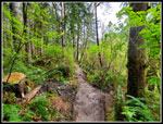
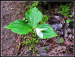
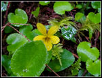
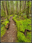
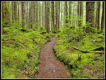
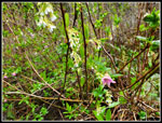
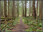
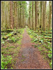
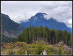
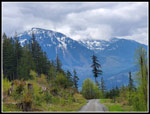
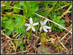
It was a cool 47 degrees at the start. I hiked the gravel road under the powerlines to the end. No views of Persis, Index, and Baring. The peaks were completely blocked by low clouds. I was going for miles so I took the railroad grade instead of the Woody Trail. The grade begins to climb slowly. The route is smooth and hikes very fast. There are markers every half mile on the railroad grade and on the Greg Ball Trail. I quickly noticed that almost no wildflowers are in bloom. All the way up to Wallace Lake I saw one trillium in bloom and a couple of patches of yellow violets. The flower show has been picking up in the Issaquah Alps and even near Bellingham last weekend. At one mile I checked my pace and I was at 3.6 mph. That is much faster than normal. It was not going to stay there long. With all the folks out ahead of me, virtually none were on my route. After 2.37 miles I reached the start of the Greg Ball Trail. I often do the Falls-Lake Loop and come down this trail. I very seldom go up it. I saw a couple of fresh mushrooms soon and as this can be a great mushroom trail I hoped for many more. Nope, no more were seen.
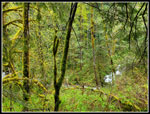
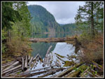
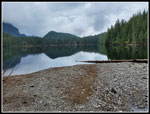
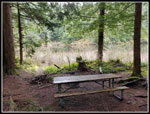
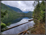
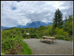
I moved a short way off the trail to see the river in a deep gorge. As I returned to the trail, I saw the back of a woman runner who had passed by. The first person seen on the trail. Just before reaching the road, I caught up with 2 other hikers. I passed them easily on the road. 4.35 miles down and a whole lot more to go. Just up the road is a sign noting it is 5.9 miles back to the trailhead via the road from there. That would be my longer route down. I turned off the road for the last .60 miles to the lake. As always, I will complain about the thick large rock layer of gravel on this old road to the lake. What was nice walking is now something to endure rather than enjoy. The gravel layer is thinner farther along. I arrived at the lake at 9:44 am. I had traveled 5 miles in 1:45. I took a quick photo down the lake from the outlet creek bridge and started around the lake. I saw a group here on their way back already. Perhaps I was not all that early.
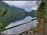
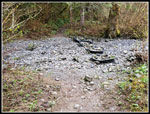
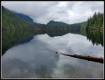
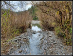
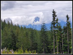
The walk around the lake goes pretty fast. Near the end, there is a short trail down to a bench near the water. On my last two trips to the lake, Pebble Beach at the inlet was completely underwater. I could look over from the bench and it looked like the lake level might be low enough for the beach to be usable. A few minutes later I was at the inlet creek. This time the creek was gone. I walked down the creek bed and there were some big puddles left. Near the end, I cut up and around the last puddle that went from side to side. Low and behold, it was back! Looking down the lake I saw only clouds above and partly covering the peaks in the near distance. There was a nice display of skunk cabbage in bloom. I had some food and water and was quickly back on my way.
I worked my way back down the creek bed with dry feet and at the main trail, I turned right. It is 1 mile more to reach Jay Lake. After a short climb, the old road/trail grade flattens for most of the way to Jay Lake. This flat trail hikes very fast. I arrived at the end of the trail and went down to the campsite near the water. The trail out to a partial view of the lake was underwater. I managed a few poor photos of brush and a little water. 10 years earlier Gary, John, and I continued on the little used end of the road a short way to the River coming from Shaw Lake and emptying into Jay Lake. I tried to follow it. It is gone. I meandered around for a while and found the last part is now just a 9 foot tall jungle of salmonberry and a few devil's club bushes. I finally started back at 10:48 am. I arrived back at the Wallace Lake inlet creek at 11:07 am. The clouds looked the same over the far end of the lakes. Still no views. I went part-way down the creek bed and saw someone at the beach. I turned around.
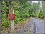
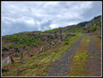
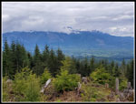
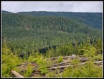
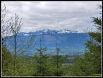
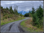
Going back around the lake, I stopped at the bend by the shore and did get some photos looking down the lake. I took a detour up to the recent logging by the old road to the lake. I had partial views of peaks to the south and east. I went to the ridge top for the first time and was surprised to see a little bit of Wallace Lake below. After my last food and water break, I headed down. There were no more stops. From the lake outlet to the car, it is about 6.5 miles via the logging road. I made excellent time the whole way. From the outlet I hiked back to the road and down to the top of the Greg Ball Trail. I passes 3 or 4 groups coming in and caught up with one going down. After I passed the GBT I saw one guy on a bike twice until near the railroad trail. I saw two more bikers coming up at that point. There is always lots of solitude on the DNR logging road. The sky was still cloudy but I did have some views out on the road. After the dark forest coming up it was quite a contrast.
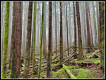
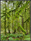
I left the road on the connector trail and much to my profound disappointment the sign showing the trail is only open to hikers carrying a rake is gone. That was one of my favorite trail signs. The sign and post are missing. I continued down the trail to find some more blooming skunk cabbage. One section has a great display of trees dripping with moss. I arrived at the Railroad Grade Trail, completing a big loop, at 1:34 pm. I had exactly 1.5 miles to go. I was getting a bit tired after 14.5 miles but the gentle smooth grade allowed for a fast finish. I calculated that I had an outside chance of getting back by 2:00 pm if I picked up my speed a bit more. The sun was now coming out and it was suddenly warm. I zipped down the trail and arrived at my car at 1:59 pm. I came down 6.6 miles from Wallace Lake in 1:56 for a speed of 3.4 mph. That was really good for me.
I had hoped to get down early enough to beat the crowds coming home on Highway 2. I had an Internet connection near Wallace Lake and at 11:67 am the WSDOT traffic site showed slowing traffic from Gold Bar through Sultan. Near the trailhead I checked again and it was now much slower with stop and go part of the way. In reality, it was bad from just before Startup to the end of Sultan. I drove from home in the morning in one hour. It took me 45 minutes just to go 6.3 miles on the highway. That did not mar my day. I still was home before 4:00 pm. It does show that even Gold Bar with an early return may be out of the question for Highway 2 on any Sunday, at least for me.
This was my longest hike of the year so far. Also one of my fastest covering 16 miles with 2000' of gain in 5:59 including all breaks and many photo stops. The sun did not come out until near the end but it never rained. The parking lot was full and I estimate about 60 more cars were parked right along both sides of the road well down from the park. Some cars were parked half a mile away. For such a popular park I had a lot of solitude. I saw only a few folks hiking up to Wallace and Jay Lakes. on the way out I saw a number of groups near the top of the Greg Ball Trail. I saw the one biker on the logging road walk and then 4 or 5 more groups on the 1.5 miles of Railroad Grade Trail. The Woody Trail to the falls was mobbed all day long. The GBT was somewhat crowded after my early trip up it. One can get in a long hike in Wallace Falls State Park without crowds. It was a fun day on the trail and my plantar fasciitis is now gone. The long road walk would have been very painful a few months ago. I felt fine at the end.
Click on thumbnails to get
larger pictures.
Trips - 2022
Home
It was a cool 47 degrees at the start. I hiked the gravel road under the powerlines to the end. No views of Persis, Index, and Baring. The peaks were completely blocked by low clouds. I was going for miles so I took the railroad grade instead of the Woody Trail. The grade begins to climb slowly. The route is smooth and hikes very fast. There are markers every half mile on the railroad grade and on the Greg Ball Trail. I quickly noticed that almost no wildflowers are in bloom. All the way up to Wallace Lake I saw one trillium in bloom and a couple of patches of yellow violets. The flower show has been picking up in the Issaquah Alps and even near Bellingham last weekend. At one mile I checked my pace and I was at 3.6 mph. That is much faster than normal. It was not going to stay there long. With all the folks out ahead of me, virtually none were on my route. After 2.37 miles I reached the start of the Greg Ball Trail. I often do the Falls-Lake Loop and come down this trail. I very seldom go up it. I saw a couple of fresh mushrooms soon and as this can be a great mushroom trail I hoped for many more. Nope, no more were seen.
I moved a short way off the trail to see the river in a deep gorge. As I returned to the trail, I saw the back of a woman runner who had passed by. The first person seen on the trail. Just before reaching the road, I caught up with 2 other hikers. I passed them easily on the road. 4.35 miles down and a whole lot more to go. Just up the road is a sign noting it is 5.9 miles back to the trailhead via the road from there. That would be my longer route down. I turned off the road for the last .60 miles to the lake. As always, I will complain about the thick large rock layer of gravel on this old road to the lake. What was nice walking is now something to endure rather than enjoy. The gravel layer is thinner farther along. I arrived at the lake at 9:44 am. I had traveled 5 miles in 1:45. I took a quick photo down the lake from the outlet creek bridge and started around the lake. I saw a group here on their way back already. Perhaps I was not all that early.
The walk around the lake goes pretty fast. Near the end, there is a short trail down to a bench near the water. On my last two trips to the lake, Pebble Beach at the inlet was completely underwater. I could look over from the bench and it looked like the lake level might be low enough for the beach to be usable. A few minutes later I was at the inlet creek. This time the creek was gone. I walked down the creek bed and there were some big puddles left. Near the end, I cut up and around the last puddle that went from side to side. Low and behold, it was back! Looking down the lake I saw only clouds above and partly covering the peaks in the near distance. There was a nice display of skunk cabbage in bloom. I had some food and water and was quickly back on my way.
I worked my way back down the creek bed with dry feet and at the main trail, I turned right. It is 1 mile more to reach Jay Lake. After a short climb, the old road/trail grade flattens for most of the way to Jay Lake. This flat trail hikes very fast. I arrived at the end of the trail and went down to the campsite near the water. The trail out to a partial view of the lake was underwater. I managed a few poor photos of brush and a little water. 10 years earlier Gary, John, and I continued on the little used end of the road a short way to the River coming from Shaw Lake and emptying into Jay Lake. I tried to follow it. It is gone. I meandered around for a while and found the last part is now just a 9 foot tall jungle of salmonberry and a few devil's club bushes. I finally started back at 10:48 am. I arrived back at the Wallace Lake inlet creek at 11:07 am. The clouds looked the same over the far end of the lakes. Still no views. I went part-way down the creek bed and saw someone at the beach. I turned around.
Going back around the lake, I stopped at the bend by the shore and did get some photos looking down the lake. I took a detour up to the recent logging by the old road to the lake. I had partial views of peaks to the south and east. I went to the ridge top for the first time and was surprised to see a little bit of Wallace Lake below. After my last food and water break, I headed down. There were no more stops. From the lake outlet to the car, it is about 6.5 miles via the logging road. I made excellent time the whole way. From the outlet I hiked back to the road and down to the top of the Greg Ball Trail. I passes 3 or 4 groups coming in and caught up with one going down. After I passed the GBT I saw one guy on a bike twice until near the railroad trail. I saw two more bikers coming up at that point. There is always lots of solitude on the DNR logging road. The sky was still cloudy but I did have some views out on the road. After the dark forest coming up it was quite a contrast.
I left the road on the connector trail and much to my profound disappointment the sign showing the trail is only open to hikers carrying a rake is gone. That was one of my favorite trail signs. The sign and post are missing. I continued down the trail to find some more blooming skunk cabbage. One section has a great display of trees dripping with moss. I arrived at the Railroad Grade Trail, completing a big loop, at 1:34 pm. I had exactly 1.5 miles to go. I was getting a bit tired after 14.5 miles but the gentle smooth grade allowed for a fast finish. I calculated that I had an outside chance of getting back by 2:00 pm if I picked up my speed a bit more. The sun was now coming out and it was suddenly warm. I zipped down the trail and arrived at my car at 1:59 pm. I came down 6.6 miles from Wallace Lake in 1:56 for a speed of 3.4 mph. That was really good for me.
I had hoped to get down early enough to beat the crowds coming home on Highway 2. I had an Internet connection near Wallace Lake and at 11:67 am the WSDOT traffic site showed slowing traffic from Gold Bar through Sultan. Near the trailhead I checked again and it was now much slower with stop and go part of the way. In reality, it was bad from just before Startup to the end of Sultan. I drove from home in the morning in one hour. It took me 45 minutes just to go 6.3 miles on the highway. That did not mar my day. I still was home before 4:00 pm. It does show that even Gold Bar with an early return may be out of the question for Highway 2 on any Sunday, at least for me.
This was my longest hike of the year so far. Also one of my fastest covering 16 miles with 2000' of gain in 5:59 including all breaks and many photo stops. The sun did not come out until near the end but it never rained. The parking lot was full and I estimate about 60 more cars were parked right along both sides of the road well down from the park. Some cars were parked half a mile away. For such a popular park I had a lot of solitude. I saw only a few folks hiking up to Wallace and Jay Lakes. on the way out I saw a number of groups near the top of the Greg Ball Trail. I saw the one biker on the logging road walk and then 4 or 5 more groups on the 1.5 miles of Railroad Grade Trail. The Woody Trail to the falls was mobbed all day long. The GBT was somewhat crowded after my early trip up it. One can get in a long hike in Wallace Falls State Park without crowds. It was a fun day on the trail and my plantar fasciitis is now gone. The long road walk would have been very painful a few months ago. I felt fine at the end.
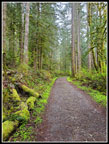 Railroad Grade |
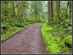 Bright Green Border |
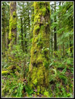 Mossy Trees |
 End Of The Grade |
 Green Greg Ball Trail |
 River Below |
 Trillium |
 Yellow Violet |
 Mossy Edges |
 Cloudy Forest |
 Really Mossy |
 DNR Road |
 Wallace Lake Outlet |
 Bench View |
 Dry Creek Bed |
 Cloudy Wallace Lake |
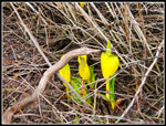 Skunk Cabbage |
 Pebble Beach |
 Big Puddles |
 Salmonberry Flower |
 Trail To Jay Lake |
 Jay Lake |
 Fungus |
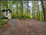
 New Outhouse |
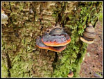 More Fungus |
 Heading To Wallace |
 Back At Bench |
 Into The Clearcut |
 View South |
 Cloudy Peaks |
 Peak Behind Lake |
 Wallace Lake Below |
 Biker On Road |
 Snowy On Ridge |
 Distant Peaks |
 Open Views |
 Spring Beauty |
 Dripping Moss |
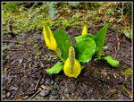 More Skunk Cabbage |
 Narrow Trail |
 New Leaves |
 Persis & Index Peaks |
Trips - 2022
Home