07/01-02/23
Day 1
Gary was free for the first two days of the Fourth of July Weekend holiday. He wanted to go on a backpacking trip and I was all for it. The last time either of us backpacked was in ear;u October 2021 when we went to Carne Basin to view golden larch trees. We were long overdue. I went to Gary's house at 6:30 am and we headed east. The day would be clear but wind gusts were forecast for up to 30 mph. We hoped that would not be the case. The bridge at the start of the Beverly Creek Trail was brand new. The Beverly Creek Road was bad at the bottom. The drain ditches across the road were very bad last fall. With the heavy equipment used for the new bridge, those dips have finally been filled in. Those bad spots were in great shape. We expected a lot of cars at the trailhead with many people taking four day weekends. We were pleasantly surprised. At 8:25 am we arrived to find only 3 other cars. We were a little concerned there might be other campers at our spot but now it looked very good.
We were packed and on our way at 8:35 am. Some remnants of the old bridge are still in the lot. We crossed the new bridge and headed up the old road/trail. There were a few wildflowers right near the start. A few penstemons and some yellow flowers I did not recognize. In about .40 miles we reached the trail junction. The Bean Creek Trail heads up Bean Creek and the Beverly Trail crosses the creek. The water is in only one channel and well below spring levels. We still had to carefully hop rocks to keep our feet dry.
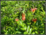
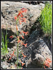
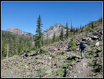
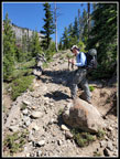
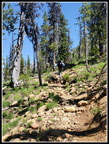
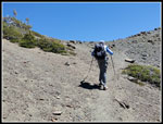
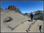
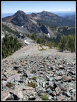
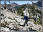
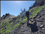
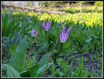
The forest walk was cool. I have seen quite a few pale roses this year. We saw some very deep red ones. Also seen were coralroot and columbine. We then came out of the forest near Beverly Creek. The wildflower show began almost at once. The star was the scarlet gilia. There was a lot of it and it was nearly all in full bloom. Our timing was excellent. The wind was blowing enough to make it hard to not get blurry photos as the long stem flowers waved in the wind. We took lots of time trying. Buckwheat and lupine were mixed in with the gilia. The wildflowers covered the sparse meadows in places. After a series of switchbacks, the trail heads directly up the valley. The flower show ends for a while. As we neared forest again, the trail was really rocky. It has always been rocky but it seems a bit worse this year. We would have lots more of trail filled with rocks. We reached the Forth Creek Trail junction at about 2.70 miles.
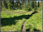
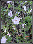
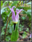
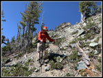
I dropped my backpack and headed on to the creek crossing to check out the wildflowers. Indian paintbrush has barely begun to flower. I did see shooting stars, yellow violets, arnica, and asters in bloom, After a short break at the junction, We headed up the Fourth Creek Trail. It too, is rocky. It too seemed to be even rockier this year. It looked like more snow melt had carried more rocks down the creek/trail bed. On the way up we saw more shotting stars and even a few bog orchids. That is the second time in three weeks. I had not seen it in 4 or 5 years. We reached the junction and headed to the right on the County Line Trail. We passed the only person we were to see all day. The creeks along this trail were all still running. That meant lots of flowers in bloom. I really like this section of trail.
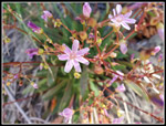
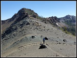
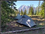
Along with shooting stars we saw the first of many Wenatchee spring beauty seen on this trip. The low lying plant has many bright pinkish flowers. After a gentle grade we crossed the last creek and the grade steepened. We were pleased to find water in the last creek as we would need to carry water up to our camp. As we climbed the creek continued to flow reducing our water distance more. We were getting tired of deep, narrow, rocky trails. This one just goes straight uphill. We reached the top and Gary showed me the campsites. We were now at about 6100' and the wind was blowing harder. Not the forecast gusts of 20-30 mph but still pretty strong. We found a good spot with a windbreak of trees and started to put up our tents. The wind then changed about 180 degrees. I changed the angle of my tent and called it good. Our tarptents did just fine.
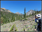
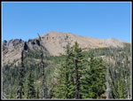
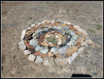
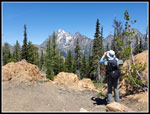
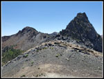
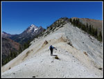
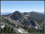
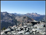
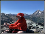
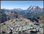
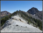
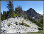
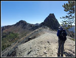
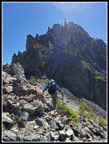
We explored the ridge top meadow for a short time and backed our now lighter tents for our next destination. Three years earlier, Gary and John had climbed to the ridge top, gone around Volcanic Neck, and followed the ridge out to Devil's Head Peak. I had heard of it but never scrambled up it. I had my hat chin strap cinched tight as we reached the ridge top. The wind was really blowing. To get around Volcanic Neck we dropped down steeply on a boot path and then climbed over a rock rib,. From there it is a steep scree climb back up to the ridge top. I had tried Volcanic Neck a couple times years ago. We passed the gully that leads up it and headed north on the ridge. It was not that difficult but is not just an easy ridge walk. We had several climbs and drops along the way. The neatest part is the bare ridge top that has bright white rock along with several other colors. I could see it from camp but up close it is really impressively different than anything else nearby.
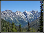
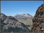
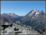
The last climb is steep on loose rock but with no exposure. We reached the summit at 2:36 pm. The view of the Stuart Range is second to none. It is right in your face. The wind was blowing hard and I had my windshirt zipped all the way up. We enjoyed the great views and did not start back until 3:18 pm. We had 42 minutes on the summit. I had wondered where the name came from. It wasn't until Gary mentioned the summit elevation is 6666' that I figured it out. The way back has some scramble parts but we took our time and did fine. We dropped down and around Volcanic Neck. Once we left the ridge the wind dropped markedly. We were back at camp at 4:25 pm. We had five hours until dark. We had dinner and walked around the ridge top meadow. Shooting stars were in the meadow next to camp. More wildflowers were around us. We noticed big larch trees too. One was covered in fresh green needles and had golden ones down low. Turning color in early July? We managed to entertain ourselves and did not turn in until about 9:00 pm. We had a full moon and each time I woke up it was light in my tent.
Click on thumbnails to get
larger pictures.
Day 2
Trips - 2023
Home
Gary was free for the first two days of the Fourth of July Weekend holiday. He wanted to go on a backpacking trip and I was all for it. The last time either of us backpacked was in ear;u October 2021 when we went to Carne Basin to view golden larch trees. We were long overdue. I went to Gary's house at 6:30 am and we headed east. The day would be clear but wind gusts were forecast for up to 30 mph. We hoped that would not be the case. The bridge at the start of the Beverly Creek Trail was brand new. The Beverly Creek Road was bad at the bottom. The drain ditches across the road were very bad last fall. With the heavy equipment used for the new bridge, those dips have finally been filled in. Those bad spots were in great shape. We expected a lot of cars at the trailhead with many people taking four day weekends. We were pleasantly surprised. At 8:25 am we arrived to find only 3 other cars. We were a little concerned there might be other campers at our spot but now it looked very good.
We were packed and on our way at 8:35 am. Some remnants of the old bridge are still in the lot. We crossed the new bridge and headed up the old road/trail. There were a few wildflowers right near the start. A few penstemons and some yellow flowers I did not recognize. In about .40 miles we reached the trail junction. The Bean Creek Trail heads up Bean Creek and the Beverly Trail crosses the creek. The water is in only one channel and well below spring levels. We still had to carefully hop rocks to keep our feet dry.
The forest walk was cool. I have seen quite a few pale roses this year. We saw some very deep red ones. Also seen were coralroot and columbine. We then came out of the forest near Beverly Creek. The wildflower show began almost at once. The star was the scarlet gilia. There was a lot of it and it was nearly all in full bloom. Our timing was excellent. The wind was blowing enough to make it hard to not get blurry photos as the long stem flowers waved in the wind. We took lots of time trying. Buckwheat and lupine were mixed in with the gilia. The wildflowers covered the sparse meadows in places. After a series of switchbacks, the trail heads directly up the valley. The flower show ends for a while. As we neared forest again, the trail was really rocky. It has always been rocky but it seems a bit worse this year. We would have lots more of trail filled with rocks. We reached the Forth Creek Trail junction at about 2.70 miles.
I dropped my backpack and headed on to the creek crossing to check out the wildflowers. Indian paintbrush has barely begun to flower. I did see shooting stars, yellow violets, arnica, and asters in bloom, After a short break at the junction, We headed up the Fourth Creek Trail. It too, is rocky. It too seemed to be even rockier this year. It looked like more snow melt had carried more rocks down the creek/trail bed. On the way up we saw more shotting stars and even a few bog orchids. That is the second time in three weeks. I had not seen it in 4 or 5 years. We reached the junction and headed to the right on the County Line Trail. We passed the only person we were to see all day. The creeks along this trail were all still running. That meant lots of flowers in bloom. I really like this section of trail.
Along with shooting stars we saw the first of many Wenatchee spring beauty seen on this trip. The low lying plant has many bright pinkish flowers. After a gentle grade we crossed the last creek and the grade steepened. We were pleased to find water in the last creek as we would need to carry water up to our camp. As we climbed the creek continued to flow reducing our water distance more. We were getting tired of deep, narrow, rocky trails. This one just goes straight uphill. We reached the top and Gary showed me the campsites. We were now at about 6100' and the wind was blowing harder. Not the forecast gusts of 20-30 mph but still pretty strong. We found a good spot with a windbreak of trees and started to put up our tents. The wind then changed about 180 degrees. I changed the angle of my tent and called it good. Our tarptents did just fine.
We explored the ridge top meadow for a short time and backed our now lighter tents for our next destination. Three years earlier, Gary and John had climbed to the ridge top, gone around Volcanic Neck, and followed the ridge out to Devil's Head Peak. I had heard of it but never scrambled up it. I had my hat chin strap cinched tight as we reached the ridge top. The wind was really blowing. To get around Volcanic Neck we dropped down steeply on a boot path and then climbed over a rock rib,. From there it is a steep scree climb back up to the ridge top. I had tried Volcanic Neck a couple times years ago. We passed the gully that leads up it and headed north on the ridge. It was not that difficult but is not just an easy ridge walk. We had several climbs and drops along the way. The neatest part is the bare ridge top that has bright white rock along with several other colors. I could see it from camp but up close it is really impressively different than anything else nearby.
The last climb is steep on loose rock but with no exposure. We reached the summit at 2:36 pm. The view of the Stuart Range is second to none. It is right in your face. The wind was blowing hard and I had my windshirt zipped all the way up. We enjoyed the great views and did not start back until 3:18 pm. We had 42 minutes on the summit. I had wondered where the name came from. It wasn't until Gary mentioned the summit elevation is 6666' that I figured it out. The way back has some scramble parts but we took our time and did fine. We dropped down and around Volcanic Neck. Once we left the ridge the wind dropped markedly. We were back at camp at 4:25 pm. We had five hours until dark. We had dinner and walked around the ridge top meadow. Shooting stars were in the meadow next to camp. More wildflowers were around us. We noticed big larch trees too. One was covered in fresh green needles and had golden ones down low. Turning color in early July? We managed to entertain ourselves and did not turn in until about 9:00 pm. We had a full moon and each time I woke up it was light in my tent.
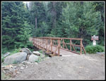 New Trailhead Bridge |
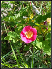 Very Red Rose |
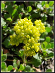
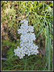 Yarrow |
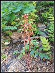 Coralroot |
 Columbine |
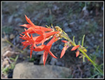 First Scarlet Gilia |
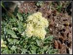 Buckwheat |
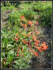 A Bunch Of Gilia |
 Tall Gilia |
 Another Buckwheat |
 Columbia Lewisia |
 Iron, Teanaway, & Bill |
 Teanaway & Bill |
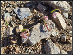
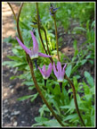 Shooting Stars |
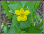 Yellow Violet |
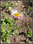 Aster |
 Rocky Trail |
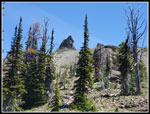
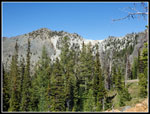
 Iron Peak |
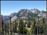
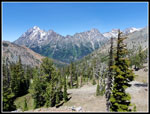
 Stuart Range |
 County Line Meadows |
 Very Rocky Trail |
 Phlox |
 Rock Display |
 Gary & Stuart |
 Volcanic Neck From Camp |
 Another Shooting Star |
 Bill & Teanaway |
 Stuart Range From Camp |
 Nearing Ridge Top |
 Ridge Top |
 Gary & Earl Peak |
 Fortune & Ingalls Peaks |
 Bean & Volcanic Neck |
 Gary On White Ridge |
 Looking South On Ridge |
 Ingalls & Stuart |
 View West From DH |
 Me On Summit |
 Looking Back From DH |
 View NW From DH |
 Gary Heading Down |
 Jim Heading Down |
 Back On Bare Ridge |
 Gary & Ridge |
 Gary, Bean, & VN |
 Nearing Volcanic Neck |
 Almost Back On Ridge |
 Bean & Ridge |
 Shooting Stars Near Camp |
 Our Campsite |
 Golden Larch? |
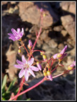
 Wenatchee Spring Beauty |
 Ridge To Devil's Head |
 Onions |
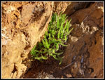 Ferns |
 Columbia Lewisia II |
Day 2
Trips - 2023
Home