09-02-23
Gary
was free for a Saturday hike
on Labor Day Weekend. We had been talking about Frog Mountain for
several weeks but the smoke was too much to go for it . The Airplane
Lake fire is close enough that the wind needs to be blowing it east to
get in a trip up Frog. Kim and I hiked Frog Mountain two years ago. The
trail was almost finished but the parking lot still had work to be
done. We had some great fall colors but the clouds covered the tops of
all the mountains that are in sight. The trip is short enough
that I wanted to add a little more distance if possible. I
knew of the fairly new Heybrook Ridge trip from Index. It is just too
short to make up a day of hiking. Adding it to Frog Mountain would
bring the day up to about 11 miles with about 3000' of gain. The
downside is that the day temperature would climb into the mid 80s by
early afternoon. That is pretty hot for me to start a second hike. We
decided to give it a shot if we still felt good. The smoke was ebbing a
little in Western Washington. We hoped it would not be a problem at
Frog Mountain.
We needed an early start to get in both trips. We met at the Bothell Park and Ridge at 6:30 am and I drove east. To add to the fun we knew that the Evergreen State Fair was going on in Monroe. The usual tough weekend traffic on westbound Highway 2 and the fair traffic was a wild card. The fact this day was the first of a holiday weekend was another unknown factor. We headed east to just past Skykomish and then up the Beckler River Road. A short section of the southbound lane was closed but otherwise it is in good shape. The pavement ends at the Rapid River and the dirt section was in surprisingly good shape. We made good time on the dirt road. There were lots of people camping right along the road. Only spot had about a dozen cars parallel parked along the road. We arrived at Jack Pass at about 7:45 am. We drove into the parking lot to find three other vehicles. A row of big rocks blocks the farther part of the lot. We packed up and headed for the trail at 7:53 am. The air was not bad. I smelled a little smoke but very little.
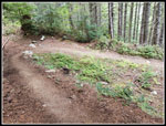
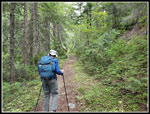
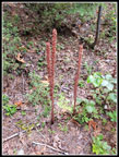
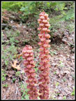
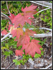
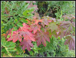
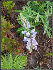
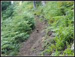
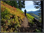
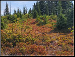
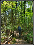
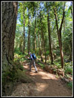
The trail begins on an old road but it feels like a trail. A minute up the trail is a short side trail to a wood pit toilet. Just like any backcountry toilet. It is good for the backcountry. I don't think many day hikers are going to like it. The trail is moderately graded all the way up. It is never steep. Most maps and reports call it 8 miles to the top. We came up with closed to 7.3 miles. The gain is 2200'. We set off at a steady but not fast pace. We had all day. After abut half a mile the trail turns sharply to the left and leaves the road. The route switches back and forth as it climbs the west side of the mountain in forest. It was nice and cool. Just like the last few weeks, we saw bunches of tall pinedrops. One clump had about 8 individual plants in a tight bunch. Wildflowers were almost entirely finished. We did see a few fireweed in bloom and Gary noticed a single lupine flower. The leaves were starting to change colors a few maples were shades of orange and red. It will get much better in a few weeks.
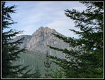
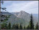
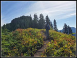
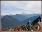
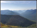
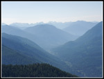
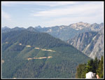
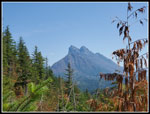
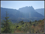
The temperature was climbing but the west side trail kept us out of the sun most of the way up. As we climbed above the forest, views began to appear. The sky was blue but there was still some smoke haze. We could see all the peaks but not crystal clear. Surprisingly, we could see the parking lot from about three miles up the trail. The route finally reached the top of the summit ridge and continued uphill partly in forest on the ridge top. We came out into the open at the first viewpoint. It looked north and south with great views. Nearly as good as the summit. A couple of hikers were there enjoying the views. They were the first of two parties we saw on the way up. We had a great view of Columbia, Kyes, and Sloan Peaks to the north. We could also see Glacier Peak with some fire smoke at the base. We continued on as the trail dropped onto the south slope. We soon had views of Mt. Daniel and Hinman, and the peaks of the Cascade Crest north of Snoqualmie Pass. They were hazy but in sight.
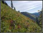
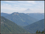
The slope was covered with ferns that were just beginning to change color. It will be orange and red soon. The trail climbs back up to the ridge just beyond the actual summit. On the way we passed the second group of hikers who were heading down. We had the flat ridge where the trail ends to ourselves. There were more great views including Mt. Rainier. West Cady Ridge is not far away. It was 10:04 as we sat down for brunch. The views were much better than on my first visit. It is clear that I need to come back on a day with no clouds or smoke. The green "tower" that was at the end of the trail is now gone. We set out for the real summit. Our map had the summit located where the trail ends which is one contour line below the real summit. We waded through some brush and then climbed a short way up to the entirely forested high point. I don't see any reason to return on future trips. Another hiker was on top. We talked a bit. Some of the low bush huckleberry plants were now backlit by the sun. That was the best fall color of the day.
We packed up at 10:52 am and headed down. The gently graded trail was easy on the knees coming down. We saw a few hikers and farther down we saw more. It was not a crowd but we periodically met groups heading up. It was now much warmer. The sun was high enough that we were in it even on the west side. When we dropped back into the forest the hiking was much cooler. We took one good food and water break but mostly continued down at a moderate pace. We reached the car at 12:34 pm. The truck next to us was one of th three we saw in the morning. A hunter was now there. He did not hike to the summit. This was the first time we saw him. There were many more cars but the lot was far from full. My car read 89 degrees as we started down but soon dropped to 84. That still felt very warm. Were we up for a second hike?
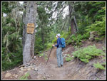
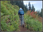
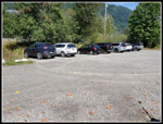
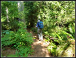
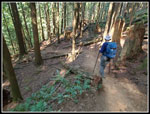
The drive back to Highway 2 went quickly. The highway had a steady stream of cars heading east but we saw almost nobody going our way. At the Index Road we turned right. In .90 miles we reached the new park. There were nine or ten cars but plenty of room left. My car read 80 degrees as we headed out. The trail is marked with markers every .25 miles most of the way up. The viewpoint is at mile post 1.66. It really felt like more. The gain is about 800'. It is in forest until near the ridge top and that helped. It as still very warm. There were hikers coming down much of the way. The grade is moderate but with some rock steps. When we popped out of the forest and onto the summit ridge we saw two hikers. A path followed the ridge top higher. We took it. Little did we know, behind the two hikers was a path the quickly goes through the trees to the viewpoint. We gained more elevation to a point where the trees were thick. There were no views. We consulted the map and found we had gone too high. We dropped down and now easily saw the path over to the viewpoint.
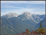
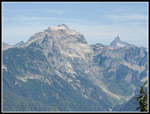
The viewpoint could be great on a clear day. Off the the left we had a great look at Mt. Baring. It is the best I have seen. Across the valley is Bridal Veil Falls below Mt. Index ad Mt. Persis. The haze was so bad I could barely make it out. On a clear day it would be great. We found a small shaded spot and sat down for a final food and water break. I was in no hurry to get down. On the other hand, we had no idea how long the drive home would take. It could be ugly until we were passed the fair in Monroe. We started up at 1:28 pm. After our detour on the summit ridge, we reached the viewpoint at 2:23 pm. We headed down at 2:42 pm. It was even hotter now but it was much easier going down. Folks were still heading up as we descended. We reached the bottom at 3:25 pm. We were soon back on Highway 2 heading home.
The drive home was much better than expected. Traffic was lighter than most weekends all the way to Monroe. A couple weeks earlier on a Saturday I took 20 minutes just to drive through Monroe, a dist distance of about .90 miles. This day we cruised right through. I had no serious traffic all the way home. This turned out to be my second multiple hike day in a week. Last weekend I did Lodge Lake and then the Snoqualmie Tunnel back to back. This time the trips were much farther apart. Then I did a hike in the cool morning air then went underground during the hot afternoon. This time the second hike was in the heat of the day. The totals were 7.5 miles for Frog Mt. and 3.3 miles to Heybrook Ridge. The total was about 10.8 miles with 3000' of elevation gain. It was a fun doubleheader. This was a very rare day for Gary as he hiked to trails for the first time on the same day. I had one first time hiked trail. The air was not bad, the haze not terrible, and the trails very nice. All in all, a great day to be out on the trails.
Click on thumbnails to get
larger pictures.
Trips - 2023
Home
We needed an early start to get in both trips. We met at the Bothell Park and Ridge at 6:30 am and I drove east. To add to the fun we knew that the Evergreen State Fair was going on in Monroe. The usual tough weekend traffic on westbound Highway 2 and the fair traffic was a wild card. The fact this day was the first of a holiday weekend was another unknown factor. We headed east to just past Skykomish and then up the Beckler River Road. A short section of the southbound lane was closed but otherwise it is in good shape. The pavement ends at the Rapid River and the dirt section was in surprisingly good shape. We made good time on the dirt road. There were lots of people camping right along the road. Only spot had about a dozen cars parallel parked along the road. We arrived at Jack Pass at about 7:45 am. We drove into the parking lot to find three other vehicles. A row of big rocks blocks the farther part of the lot. We packed up and headed for the trail at 7:53 am. The air was not bad. I smelled a little smoke but very little.
The trail begins on an old road but it feels like a trail. A minute up the trail is a short side trail to a wood pit toilet. Just like any backcountry toilet. It is good for the backcountry. I don't think many day hikers are going to like it. The trail is moderately graded all the way up. It is never steep. Most maps and reports call it 8 miles to the top. We came up with closed to 7.3 miles. The gain is 2200'. We set off at a steady but not fast pace. We had all day. After abut half a mile the trail turns sharply to the left and leaves the road. The route switches back and forth as it climbs the west side of the mountain in forest. It was nice and cool. Just like the last few weeks, we saw bunches of tall pinedrops. One clump had about 8 individual plants in a tight bunch. Wildflowers were almost entirely finished. We did see a few fireweed in bloom and Gary noticed a single lupine flower. The leaves were starting to change colors a few maples were shades of orange and red. It will get much better in a few weeks.
The temperature was climbing but the west side trail kept us out of the sun most of the way up. As we climbed above the forest, views began to appear. The sky was blue but there was still some smoke haze. We could see all the peaks but not crystal clear. Surprisingly, we could see the parking lot from about three miles up the trail. The route finally reached the top of the summit ridge and continued uphill partly in forest on the ridge top. We came out into the open at the first viewpoint. It looked north and south with great views. Nearly as good as the summit. A couple of hikers were there enjoying the views. They were the first of two parties we saw on the way up. We had a great view of Columbia, Kyes, and Sloan Peaks to the north. We could also see Glacier Peak with some fire smoke at the base. We continued on as the trail dropped onto the south slope. We soon had views of Mt. Daniel and Hinman, and the peaks of the Cascade Crest north of Snoqualmie Pass. They were hazy but in sight.
The slope was covered with ferns that were just beginning to change color. It will be orange and red soon. The trail climbs back up to the ridge just beyond the actual summit. On the way we passed the second group of hikers who were heading down. We had the flat ridge where the trail ends to ourselves. There were more great views including Mt. Rainier. West Cady Ridge is not far away. It was 10:04 as we sat down for brunch. The views were much better than on my first visit. It is clear that I need to come back on a day with no clouds or smoke. The green "tower" that was at the end of the trail is now gone. We set out for the real summit. Our map had the summit located where the trail ends which is one contour line below the real summit. We waded through some brush and then climbed a short way up to the entirely forested high point. I don't see any reason to return on future trips. Another hiker was on top. We talked a bit. Some of the low bush huckleberry plants were now backlit by the sun. That was the best fall color of the day.
We packed up at 10:52 am and headed down. The gently graded trail was easy on the knees coming down. We saw a few hikers and farther down we saw more. It was not a crowd but we periodically met groups heading up. It was now much warmer. The sun was high enough that we were in it even on the west side. When we dropped back into the forest the hiking was much cooler. We took one good food and water break but mostly continued down at a moderate pace. We reached the car at 12:34 pm. The truck next to us was one of th three we saw in the morning. A hunter was now there. He did not hike to the summit. This was the first time we saw him. There were many more cars but the lot was far from full. My car read 89 degrees as we started down but soon dropped to 84. That still felt very warm. Were we up for a second hike?
The drive back to Highway 2 went quickly. The highway had a steady stream of cars heading east but we saw almost nobody going our way. At the Index Road we turned right. In .90 miles we reached the new park. There were nine or ten cars but plenty of room left. My car read 80 degrees as we headed out. The trail is marked with markers every .25 miles most of the way up. The viewpoint is at mile post 1.66. It really felt like more. The gain is about 800'. It is in forest until near the ridge top and that helped. It as still very warm. There were hikers coming down much of the way. The grade is moderate but with some rock steps. When we popped out of the forest and onto the summit ridge we saw two hikers. A path followed the ridge top higher. We took it. Little did we know, behind the two hikers was a path the quickly goes through the trees to the viewpoint. We gained more elevation to a point where the trees were thick. There were no views. We consulted the map and found we had gone too high. We dropped down and now easily saw the path over to the viewpoint.
The viewpoint could be great on a clear day. Off the the left we had a great look at Mt. Baring. It is the best I have seen. Across the valley is Bridal Veil Falls below Mt. Index ad Mt. Persis. The haze was so bad I could barely make it out. On a clear day it would be great. We found a small shaded spot and sat down for a final food and water break. I was in no hurry to get down. On the other hand, we had no idea how long the drive home would take. It could be ugly until we were passed the fair in Monroe. We started up at 1:28 pm. After our detour on the summit ridge, we reached the viewpoint at 2:23 pm. We headed down at 2:42 pm. It was even hotter now but it was much easier going down. Folks were still heading up as we descended. We reached the bottom at 3:25 pm. We were soon back on Highway 2 heading home.
The drive home was much better than expected. Traffic was lighter than most weekends all the way to Monroe. A couple weeks earlier on a Saturday I took 20 minutes just to drive through Monroe, a dist distance of about .90 miles. This day we cruised right through. I had no serious traffic all the way home. This turned out to be my second multiple hike day in a week. Last weekend I did Lodge Lake and then the Snoqualmie Tunnel back to back. This time the trips were much farther apart. Then I did a hike in the cool morning air then went underground during the hot afternoon. This time the second hike was in the heat of the day. The totals were 7.5 miles for Frog Mt. and 3.3 miles to Heybrook Ridge. The total was about 10.8 miles with 3000' of elevation gain. It was a fun doubleheader. This was a very rare day for Gary as he hiked to trails for the first time on the same day. I had one first time hiked trail. The air was not bad, the haze not terrible, and the trails very nice. All in all, a great day to be out on the trails.
 Sharp Switchback |
 Nice New Trail |
 Pinedrops |
 Closer Look |
 Great Leaf Colors |
 Bunchberry Berries |
 Bear Mountain |
 Wild Sky Wilderness |
 Getting Higher |
 More Leaf Colors |
 Lots Of Ferns |
 Blooming Lupine |
 Hillside Meadow |
 Grouse |
 Ridge Top |
 Mountain Views |
 Hikers At Viewpoint |
 View South |
 Nice Colors |
 Kyes & Sloan Peaks |
 Summit Colors |
 Hazy Views South |
 San Juan Hill |
 Hazy Glacier Peak |
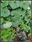 Big Wild Ginger |
 Heybrook Ridge Park |
 On Heybrook Trail |
 Gary On Trail |
 Mt. Baring |
 Hazy Mt. Index |
 Heading Down |
 Nice Trail |
Trips - 2023
Home