04-22-23
I
did a 9 mile hike with 2600' of
gain the afternoon before. I was home by 7:30 pm and ready to go hiking
the next morning. This has been an awful hiking month. A sore knee kept
me at only 3 hike the first 20 days. With 10 days to go I had 24 miles
with 5300' of gain. I needed a strong finish or this would be my worst
month in more than a decade. I had only a little rain on Friday's hike.
Saturday had early rain then it looked to be cloudy and dry until
early evening. I wanted to get in a long hike without snow to slow me
down. Low elevation might provide wildflowers which have been late to
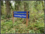
appear this year. I chose a close in low elevation hike. Grand Ridge
fit all the requirements. I had hoped to get an early start. After the
late finish the day before, I did not get an especially early start.
Doppler showed it would likely be raining until at least 8:00 am. I was
on the road at about 8:00 am. I had light rain for the majority of my
drive. I arrived at High Point at 8:35 am with a very light mist
falling. By 8:39 am I was on my way. There were four other cars in the
small lot.
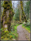
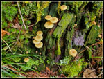
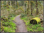
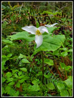
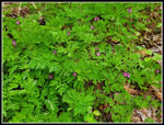
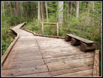
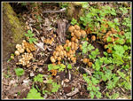
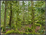
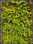
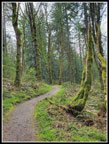
I brought an umbrella but did not use it. The first .60 miles is at a very gentle downhill grade making it easy to go fast. It was cool enough that I needed to warm up too. On 1-09-22 I did a 14 mile long hike on Grand Ridge with 2200' of elevation gain. My hope was that I would feel good enough after the hike the day before to do that route. That would give me 23 miles with 4800' of gain in about 24 hours. I do not have the plantar fasciitis that made the 2022 trip to difficult. I was a a bit sore at the start however. At the first junction I headed uphill. These are primarily bicycle trails so they are not as steep as many hiking trails. All the better for me this day. As I ascended, the wildflower show began. The trillium were no surprise. I had seen them across the road on Tiger Mountain the day before. Some tiny mushrooms on a log were a nice surprise. Though I had a long trip planned, I had all day. I would stop for a lot of photo opportunities. The wet ground and mosses and cloudy sky brought out some great colors.
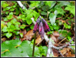
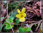
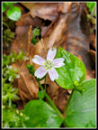
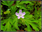
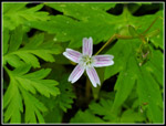
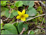
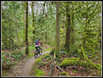
My next surprises were bleeding hearts and yellow violets in bloom. Not a lot but in several places. In the first mile I had seen three of the flowers I saw a week earlier on South Tiger Mountain. I saw a couple runners on the uphill section. At the "T" junction where the trail from Central Park comes in I saw two runners cross right ahead of me heading in. A minute later I passed two runners coming out. At first I saw 4 or so groups of runners. After that it was mostly bikers. As is often the case on Grand Ridge, I saw people most of the rest of the day but had long periods of solitude as well. I reached the one road crossing at 2.3 miles in 54 minutes. Not a great pace but I had taken quite a few photos. I continued to see more trillium and bleeding hearts.
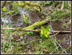
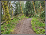
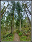
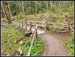
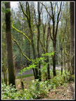
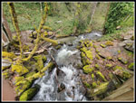
I passed both ends of the Water Tower Loop and descended to a low point where a small creek flows. This spot often has blooming skunk cabbage in the spring and that was the case this day. Just a few but they are bright yellow. I climbed up and reached the start of the Mitchell Hill Connector Trail. I hoped to do this steep climb to add about 400' of elevation gain. I decided to pass for now and hope I felt well enough on the way back to hike it. The route drops down to the WTA Bridge over Canyon Creek. The bridge is at about 4.25 miles. I arrived at 10:24 am. I took 1:45 to reach it. I continued on and passed the erratic rock alongside the trail a few minutes later. I often hike just beyond that and turn around for a 9 mile hike. Much less often, I continue to the other end of the trail. The next section is mostly flat with lots of sword ferns and then a forest of big cedar trees.
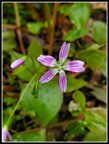
The route then begins the descent to the Michael O Bridge. This turned out to be the best wildflower show I have seen this year. There were some trillium in bloom then some yellow violets. Then I reached the blooming bleeding hearts. I had been seeing hundreds of bleeding heart plants along the way. Most were not yet blooming. Now I saw clumps of dozens of flowers together. They were still very dark red. I was sore enough to not appreciate getting down on the ground for photos and then getting back up again. The flower show was too good not to. Then the spring beauties starting to show up. I had not seen a single one so far this year. They were in numerous shades and colors. They are very small flowers that required me to get up and down many more times. My pace was glacial but after a very slow wildflower season this was very welcome.
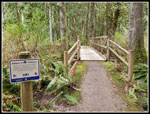
I reached the Michael O Bridge at 11:04 am. The bridge is really a raised boardwalk across a marshy wetland. There were a few more skunk cabbage in bloom. The bridge is about .10 miles long. There are several wide spots for easy passing. One has a bench and a horse tie up. Once across the bridge, the trail switchbacks up to gain about 130' to the northern trailhead of Grand Ridge Park. I arrived at 11:14 am. I crossed the road to the start of the Duthie Hill Mountain Bike Trails. It was time for a lunch break. I took 2:34 to hike 6.4 miles.
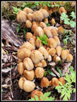
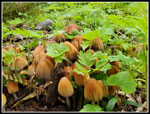
I packed up and headed back at 11:22 am after a very short lunch. I dropped down to the Michael O Bridge. I climbed up the other side taking more photo stops. I knew this is where the bulk of the wildflowers were. I noticed a mass of mushrooms next to a tree that I had completely missed on the hike in. A little later I saw another one I had walked by earlier. I reached the flat area with the big trees and took some wide angle photos of the entire trees from ground to sky. I took one more short break at the WTA Bridge. Now it was all uphill to the Mitchell Hill Trail. It began to rain a little but I only felt it in spots where the forest was open. I never did pull out my umbrella. By the time I reached the junction I had decided to head up the Mitchell Hill Trail. Adding 400' would put me just over 10,000' for the month. The day had warmed considerably. I had gloves on at the start. Now it was humid and I had my sleeves rolled up. On the steep climb I was sweating profusely. The trail grade moderates and then drops a little before a small rise to the end at a private road. I stopped to finish off most of my water, eat a little more, and change into a dry short sleeve shirt. It was a little chilly on the descent but I felt much better.
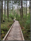
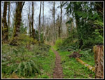
Back at the junction I turned left and continued for the final 3.7 miles. Down to the low spot then up and another descent to the road crossing. I picked up my pace for the descent to the old railroad grade on which I started the hike. The last .60 miles is that gentle uphill. It felt much warmer as I descended. Not having plantar meant no heel pain, even after 14 miles. My legs were tired by my feet felt fine. I reached my car at 2:42 pm. To my surprise, it had warmed up to 61 degrees. For the day I hiked 14 miles with 2200' of gain in 6:03. My 2022 hike on the same route took me 5:57. It was a time difference of only 6 minutes. In the 24 hours 31 minutes since I started hiking the day before, I covered 23 miles with 4800' of gain. That is how you resurrect a historically bad hiking month.
Click on thumbnails to get
larger pictures.
Trips - 2023
Home
I brought an umbrella but did not use it. The first .60 miles is at a very gentle downhill grade making it easy to go fast. It was cool enough that I needed to warm up too. On 1-09-22 I did a 14 mile long hike on Grand Ridge with 2200' of elevation gain. My hope was that I would feel good enough after the hike the day before to do that route. That would give me 23 miles with 4800' of gain in about 24 hours. I do not have the plantar fasciitis that made the 2022 trip to difficult. I was a a bit sore at the start however. At the first junction I headed uphill. These are primarily bicycle trails so they are not as steep as many hiking trails. All the better for me this day. As I ascended, the wildflower show began. The trillium were no surprise. I had seen them across the road on Tiger Mountain the day before. Some tiny mushrooms on a log were a nice surprise. Though I had a long trip planned, I had all day. I would stop for a lot of photo opportunities. The wet ground and mosses and cloudy sky brought out some great colors.
My next surprises were bleeding hearts and yellow violets in bloom. Not a lot but in several places. In the first mile I had seen three of the flowers I saw a week earlier on South Tiger Mountain. I saw a couple runners on the uphill section. At the "T" junction where the trail from Central Park comes in I saw two runners cross right ahead of me heading in. A minute later I passed two runners coming out. At first I saw 4 or so groups of runners. After that it was mostly bikers. As is often the case on Grand Ridge, I saw people most of the rest of the day but had long periods of solitude as well. I reached the one road crossing at 2.3 miles in 54 minutes. Not a great pace but I had taken quite a few photos. I continued to see more trillium and bleeding hearts.
I passed both ends of the Water Tower Loop and descended to a low point where a small creek flows. This spot often has blooming skunk cabbage in the spring and that was the case this day. Just a few but they are bright yellow. I climbed up and reached the start of the Mitchell Hill Connector Trail. I hoped to do this steep climb to add about 400' of elevation gain. I decided to pass for now and hope I felt well enough on the way back to hike it. The route drops down to the WTA Bridge over Canyon Creek. The bridge is at about 4.25 miles. I arrived at 10:24 am. I took 1:45 to reach it. I continued on and passed the erratic rock alongside the trail a few minutes later. I often hike just beyond that and turn around for a 9 mile hike. Much less often, I continue to the other end of the trail. The next section is mostly flat with lots of sword ferns and then a forest of big cedar trees.
The route then begins the descent to the Michael O Bridge. This turned out to be the best wildflower show I have seen this year. There were some trillium in bloom then some yellow violets. Then I reached the blooming bleeding hearts. I had been seeing hundreds of bleeding heart plants along the way. Most were not yet blooming. Now I saw clumps of dozens of flowers together. They were still very dark red. I was sore enough to not appreciate getting down on the ground for photos and then getting back up again. The flower show was too good not to. Then the spring beauties starting to show up. I had not seen a single one so far this year. They were in numerous shades and colors. They are very small flowers that required me to get up and down many more times. My pace was glacial but after a very slow wildflower season this was very welcome.
I reached the Michael O Bridge at 11:04 am. The bridge is really a raised boardwalk across a marshy wetland. There were a few more skunk cabbage in bloom. The bridge is about .10 miles long. There are several wide spots for easy passing. One has a bench and a horse tie up. Once across the bridge, the trail switchbacks up to gain about 130' to the northern trailhead of Grand Ridge Park. I arrived at 11:14 am. I crossed the road to the start of the Duthie Hill Mountain Bike Trails. It was time for a lunch break. I took 2:34 to hike 6.4 miles.
I packed up and headed back at 11:22 am after a very short lunch. I dropped down to the Michael O Bridge. I climbed up the other side taking more photo stops. I knew this is where the bulk of the wildflowers were. I noticed a mass of mushrooms next to a tree that I had completely missed on the hike in. A little later I saw another one I had walked by earlier. I reached the flat area with the big trees and took some wide angle photos of the entire trees from ground to sky. I took one more short break at the WTA Bridge. Now it was all uphill to the Mitchell Hill Trail. It began to rain a little but I only felt it in spots where the forest was open. I never did pull out my umbrella. By the time I reached the junction I had decided to head up the Mitchell Hill Trail. Adding 400' would put me just over 10,000' for the month. The day had warmed considerably. I had gloves on at the start. Now it was humid and I had my sleeves rolled up. On the steep climb I was sweating profusely. The trail grade moderates and then drops a little before a small rise to the end at a private road. I stopped to finish off most of my water, eat a little more, and change into a dry short sleeve shirt. It was a little chilly on the descent but I felt much better.
Back at the junction I turned left and continued for the final 3.7 miles. Down to the low spot then up and another descent to the road crossing. I picked up my pace for the descent to the old railroad grade on which I started the hike. The last .60 miles is that gentle uphill. It felt much warmer as I descended. Not having plantar meant no heel pain, even after 14 miles. My legs were tired by my feet felt fine. I reached my car at 2:42 pm. To my surprise, it had warmed up to 61 degrees. For the day I hiked 14 miles with 2200' of gain in 6:03. My 2022 hike on the same route took me 5:57. It was a time difference of only 6 minutes. In the 24 hours 31 minutes since I started hiking the day before, I covered 23 miles with 4800' of gain. That is how you resurrect a historically bad hiking month.
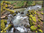 Issaquah Creek |
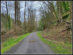 Railroad Grade |
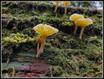 Small Mushrooms |
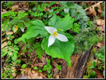 First Trillium |
 Fist Bleeding Hearts |
 Yellow Violet |
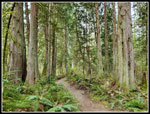
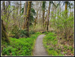
 Winding Trail |
 More Mushrooms |
 Mossy Arch |
 Skunk Cabbage |
 Tilting Left |
 WTA Bridge |
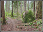 Mossy Erratic |
 More Trillium |
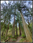 Tall Cedars |
 Cedar Forest |
 First Spring Beauty |
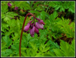 Perfect Bleeding Hearts |
 Bleeding Heart Plants |
 Colorful Spring Beauty |
 Many Bleeding Hearts |
 One More |
 Great Colors |
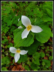 Nice Trillium |
 Michael O Bridge |
 Park Entrance |
 Cedar Gate |
 Another Yellow Violet |
 Michael O Again |
 Mess Of Mushrooms |
 Closer Look |
 Ground Level |
 Really Mossy |
 Mountain Biker |
 Second Bridge |
 Mitchell Hill Connector |
 Thick Moss |
 More Mossy Trees |
 Nearing Railroad Grade |
 Almost Back |
Trips - 2023
Home