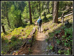
06-26-23
The
wildfire smoke was back. Gary
and I tried to figure out if there was anywhere without a lot of smoke.
We spoke Friday night and decided to pick several places to the west
and south and then make a final decision early Saturday morning. The
smoke was worse to the north and we chose not to head that way. I
brought up Highway 410 and Gary suggested the Ranger Creek Trail with a
short off trail climb to what we call Ignoble Knob. On I-90 we
considered a one way trip on Rattlesnake Mountain. Issaquah was
forecasting 90 degrees and the AQI on Friday was over 100. Most areas
were similar. Crystal Mountain was in the AQI 70s on Friday. With the
heat we needed an early start. Gary called at 5:30 am and we both said
the obvious. The few stations on Highway n18 were showing an AQI of
about 60. Most other areas were well over 100. I headed south to Gary's
home and we continued through Enumclaw and onto Highway 410. We reached
the trailhead at 720 am. By 7:26 am we were on the trail. We were not
surprised to be the first car at the start.
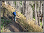
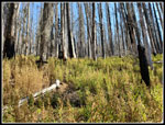
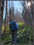
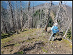
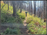
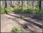
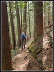
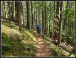
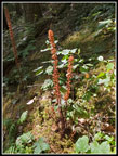
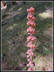
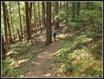
There was a very slight smoky smell but the air was mostly clear. We put on masks and found it very easy to hike with an N95. The smell quickly ended as we climbed out of the valley. On reason we chose this trail is that it is heavily forested most of the way up. It is also very smooth with a steady moderate grade. Just the thing for a hot day. We soon were seeing patches of saprophytes. There were a few coralroots and more pinedrops. Reaching the summit would entail 12 miles with 3400' of gain. We did not expect to make it that far but the conditions were so much better than expected. We maintained a steady pace and the miles started mounting. Over the course of the whole day, we saw three mountain bikers. There was plenty of solitude.
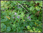
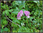
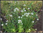
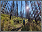
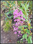
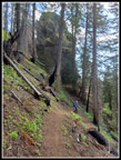
We passed by the short trail to the viewpoint. At one point the trail goes into the recent burn and passes burned up trees. At a switchback here the trail is very sketchy. Not hard to follow, just very little flat trail around the switchback. We reached the old shelter site at 9:50 am. We were 4.5 miles along with just under 1.5 miles to go to the top of Ignoble Knob. The Palisades Trail meets our trail here. We took a 20 minute break here. Time for food and water. It was getting warmer though we were still in forest. I went ahead and put on sunscreen. The last 1.4 miles was mostly through the burn. Right after the fire we hiked up on spring and found a bounty of wildflowers. This time of year there were very few on the entire hike. The trail is narrower and in poorer shape than below. It is still fine as the grade remains moderate.
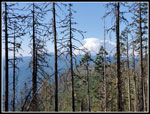
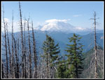
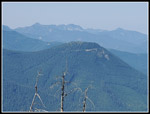
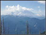
On the long rightward traverse we started to see a bit of Mt. Rainier through the burned trees. Soon we had a spot where the mountain was nearly out of the trees. There was a big white cloud sitting on the left side of the summit and otherwise almost all blue sky. There did not seem to much of any haze to the south. We reached the Dalles Ridge Trail. We were now just .60 miles from the Dalles Ridge Trailhead. Our route was over 5 miles longer with over 3000' of additional elevation gain. Who wants to do it the easy way? This was where we thought we might run into other hikers. We turned left a very short way and headed uphill. The trail to the summit of Ignoble Knob is short but steep. The trees are mostly burned and there is still a little soot on the trees. It was now getting much warmer. As we moved into the open the sun really beat down on us. We reached the top at 10:53 am. I brought along my chrome dome umbrella. It was the only shade I had until we dropped down into the forest again.
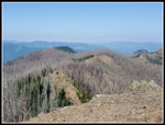
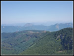
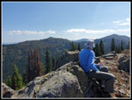
The highest point on the ridge top is 5781'. We started at 2523'. That gave us a net gain of 3258'. The evening before we were just hoping to get in some hike of hike. I was expecting the smoke and heat to have us turning around before the top. In fact, we had conditions as good as we could have hoped for. To the south the view of Rainier was still good though now the upper mountain had more clouds. There were other clouds to the south. To the north it was not very cloudy but it was very hazy. The peaks of the Cascade Crest north of Snoqualmie Pass normally stand out. Now we could barely make them out. It took a while to find Mt. Stuart though it towers over peaks in its vicinity. We were glad we were not up there in considerably more smoke. In a move I have done only once or twice in 41 years of hiking, forgot me grab my hat from the car. Half a mile into the trip I realized it. Instead of going back down I planned to put on a windshirt with a hood on to_p. I later realized I had the Chrome Dome. It worked perfectly to keep from burning my scalp.
We finally strolled down the ridge to what might be a higher point, It is very hard to tell among three places. Satisfied that one of them was the highest point, we went back to the end of the ridge. We felt like just enjoying the clear air and sunshine but realized it was only getting hotter for our hike down. At 11:56 am we started down. The steep start with loose rocks slowed us down. Soon enough we were back on trail at the junction. Now it was time to enjoy the mostly smooth and gently graded trail on the descent. The upper trail is narrow and had some deep elk made holes in the tread. Below the shelter site it was mostly easy hiking. We took another break at the shelter site. Some food and water helped. Just before we left a long biker came down the trail. He started at the bottom of the Corral Pass Road. We hiked up the steep road then on the trail over to the Ranger Creek Trail. Now he was doing the downhill part of his loop. We left after him.
Other than the collapsed switchback in the burn, the trail was very nice. With about 2.5 miles to go we picked up the pace. After about 9.5 miles and 3400' of gain we set into about a 20 minute mile pace. We took one more water break and I stopped for more saprophyte photos. Otherwise, it was a fast hiking to the finish. Of course, fast hiking is not the same as it was 20+ years ago but it was fast for us. After passing the third and last bicycler near the bottom, we reached the car at 2:35 pm. It was now very hot. The forest had blocked the direct sunshine but it was steaming alongside the highway. A small patch of shade was right on the car. That was appreciated. We were on the trail for 7:09. That included several stops and just over an hour on the summit. The car read 89 degrees when we started back but it dropped to the low-mid 80s once underway. That is still pretty toasty for hiking.
This trip turned out so much better than I was expecting. A check of Purple Air on the summit and on the drive home verified that the air in the Puget Sound Basin was bad all day. The AQI at my house was in the 120-140 range all day. The mountains north of our trip were better but still far from clear. We had a rare spot of good air. A little planning and a lot of luck gave us a much better day to be outside recreating than most people found. For the day we hiked just short of 12 miles with 3400' of elevation gain. A very fine day was very much enjoyed.
Click on thumbnails to get
larger pictures.
Trips - 2023
Home
There was a very slight smoky smell but the air was mostly clear. We put on masks and found it very easy to hike with an N95. The smell quickly ended as we climbed out of the valley. On reason we chose this trail is that it is heavily forested most of the way up. It is also very smooth with a steady moderate grade. Just the thing for a hot day. We soon were seeing patches of saprophytes. There were a few coralroots and more pinedrops. Reaching the summit would entail 12 miles with 3400' of gain. We did not expect to make it that far but the conditions were so much better than expected. We maintained a steady pace and the miles started mounting. Over the course of the whole day, we saw three mountain bikers. There was plenty of solitude.
We passed by the short trail to the viewpoint. At one point the trail goes into the recent burn and passes burned up trees. At a switchback here the trail is very sketchy. Not hard to follow, just very little flat trail around the switchback. We reached the old shelter site at 9:50 am. We were 4.5 miles along with just under 1.5 miles to go to the top of Ignoble Knob. The Palisades Trail meets our trail here. We took a 20 minute break here. Time for food and water. It was getting warmer though we were still in forest. I went ahead and put on sunscreen. The last 1.4 miles was mostly through the burn. Right after the fire we hiked up on spring and found a bounty of wildflowers. This time of year there were very few on the entire hike. The trail is narrower and in poorer shape than below. It is still fine as the grade remains moderate.
On the long rightward traverse we started to see a bit of Mt. Rainier through the burned trees. Soon we had a spot where the mountain was nearly out of the trees. There was a big white cloud sitting on the left side of the summit and otherwise almost all blue sky. There did not seem to much of any haze to the south. We reached the Dalles Ridge Trail. We were now just .60 miles from the Dalles Ridge Trailhead. Our route was over 5 miles longer with over 3000' of additional elevation gain. Who wants to do it the easy way? This was where we thought we might run into other hikers. We turned left a very short way and headed uphill. The trail to the summit of Ignoble Knob is short but steep. The trees are mostly burned and there is still a little soot on the trees. It was now getting much warmer. As we moved into the open the sun really beat down on us. We reached the top at 10:53 am. I brought along my chrome dome umbrella. It was the only shade I had until we dropped down into the forest again.
The highest point on the ridge top is 5781'. We started at 2523'. That gave us a net gain of 3258'. The evening before we were just hoping to get in some hike of hike. I was expecting the smoke and heat to have us turning around before the top. In fact, we had conditions as good as we could have hoped for. To the south the view of Rainier was still good though now the upper mountain had more clouds. There were other clouds to the south. To the north it was not very cloudy but it was very hazy. The peaks of the Cascade Crest north of Snoqualmie Pass normally stand out. Now we could barely make them out. It took a while to find Mt. Stuart though it towers over peaks in its vicinity. We were glad we were not up there in considerably more smoke. In a move I have done only once or twice in 41 years of hiking, forgot me grab my hat from the car. Half a mile into the trip I realized it. Instead of going back down I planned to put on a windshirt with a hood on to_p. I later realized I had the Chrome Dome. It worked perfectly to keep from burning my scalp.
We finally strolled down the ridge to what might be a higher point, It is very hard to tell among three places. Satisfied that one of them was the highest point, we went back to the end of the ridge. We felt like just enjoying the clear air and sunshine but realized it was only getting hotter for our hike down. At 11:56 am we started down. The steep start with loose rocks slowed us down. Soon enough we were back on trail at the junction. Now it was time to enjoy the mostly smooth and gently graded trail on the descent. The upper trail is narrow and had some deep elk made holes in the tread. Below the shelter site it was mostly easy hiking. We took another break at the shelter site. Some food and water helped. Just before we left a long biker came down the trail. He started at the bottom of the Corral Pass Road. We hiked up the steep road then on the trail over to the Ranger Creek Trail. Now he was doing the downhill part of his loop. We left after him.
Other than the collapsed switchback in the burn, the trail was very nice. With about 2.5 miles to go we picked up the pace. After about 9.5 miles and 3400' of gain we set into about a 20 minute mile pace. We took one more water break and I stopped for more saprophyte photos. Otherwise, it was a fast hiking to the finish. Of course, fast hiking is not the same as it was 20+ years ago but it was fast for us. After passing the third and last bicycler near the bottom, we reached the car at 2:35 pm. It was now very hot. The forest had blocked the direct sunshine but it was steaming alongside the highway. A small patch of shade was right on the car. That was appreciated. We were on the trail for 7:09. That included several stops and just over an hour on the summit. The car read 89 degrees when we started back but it dropped to the low-mid 80s once underway. That is still pretty toasty for hiking.
This trip turned out so much better than I was expecting. A check of Purple Air on the summit and on the drive home verified that the air in the Puget Sound Basin was bad all day. The AQI at my house was in the 120-140 range all day. The mountains north of our trip were better but still far from clear. We had a rare spot of good air. A little planning and a lot of luck gave us a much better day to be outside recreating than most people found. For the day we hiked just short of 12 miles with 3400' of elevation gain. A very fine day was very much enjoyed.
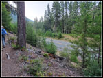 At The Start |
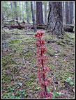 Pinedrop |
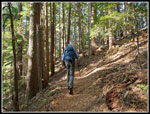 Smooth Trail |
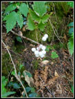 White Berries |
 Entering The Burn |
 Asters |
 Penstemon |
 Pearly Everlasting |
 Thick Fireweed In Burn |
 Sun Is Shining |
 Blooming Fireweed |
 First Mt. Rainier View |
 Off Trail To The Summit |
 Mt. Rainier From Summit |
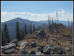 Summit Ridge |
 The Burn |
 Sun Top Mountain |
 Hazy View North |
 Gary & Noble Knob |
 Cloudy Mt. Rainier |
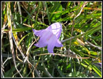 Harebell |
 Heading Down |
 Back In The Fireweed |
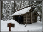 Shelter In 2010 |
 Shelter Site In 2023 |
 Big Rock |
 In The Trees |
 Mossy Ground Cover |
 Saprophytes Again |
 Lit Up Pinedrop |
 Near The Bottom |
 Sunshine Near Highway |
Trips - 2023
Home