07-16-23
Gary
and I were set for a hike near Sunrise at Mt. Rainier. Unfortunately,
at 5:10 am he emailed and then called to let me know he was not feeling
well. A two hour drive into the mountains was not a good idea.
I had to change plans fast. I came up with an old favorite. Not a long
drive and a very nicely graded trail. A chance to get in lots of miles
and elevation gain. Time to return to the Pacific Crest Trail (PCT)
north of Snoqualmie Pass. It was early enough that I could get to the
trailhead ahead of most of the hordes who hike the trail very weekend
in the summer. I was out the door at about 5:50 am. Traffic is light at
that hour. I arrived at the PCT trailhead at about 6:55 am. It was
mostly full as Ridge Lake is a popular backpacking destination. I was
on the trail at 7:00 am. One group left ahead of me and I just beat two
backpackers.
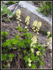
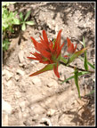
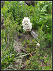
The wildflower show is past prime at lower and higher elevations. I did still find smaller amounts of quite a few flowers in bloom. In the first half mile I saw several dark blue monkshood in bloom. I had not seen them in four or five years. It was 53 degrees when I started but it warmed up fast. I was forecast to reach the mid 70s in the afternoon. After about .70 miles I had to stop to switch into a short sleeve shirt and zip off my pants legs. It was humid enough that the change really cooled me off. I set a steady pace up the trail.
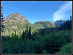
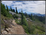
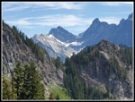
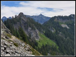
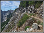
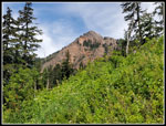
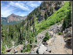
Where the trail descends through a rock field, I had great views of Guye Peak, Snoqualmie Mountain, Lundin Peak, and Red Mountain. The sky was blue and the sun was still very low in the sky. The lighting was great. I passed the junction with the Commonwealth Basin Trail and did not see the 4 km marker. I did see it on the way down. That put me almost half way to the Katwalk though I would be in forest for some time. I passed the one group that started ahead of me and began to see backpackers coming down. On the way up I passed five hikers and was passed by two runners. An early start provided quite a bit of solitude on a busy trail.
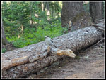
There are three big trees down on the trail. Two I had to crawl under. The biggest one is about 3.5 miles up near the ridge top. I took one break on the way up. The trail reaches the ridge top and a dry campsite. It then drops a bit and soon leaves the forest. I no sooner sat down when a camp robber jay joined me. As I started back to the trail a lone hiker went by. I followed her. We talked all the way up to the Katwalk, here turnaround spot. I picked up my pace to keep up and found I was hiking much faster than before.
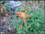
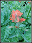
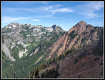
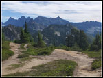
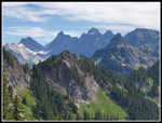
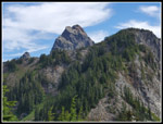
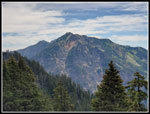
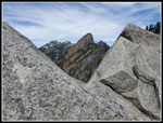
We reached the open rocky slopes of Kendall Gardens and quickly had a view of Mt. Rainier. It was clear with no haze. Clearer than I have seen it in quite a while. There were wildflowers along here but not a lot. I saw some Indian paintbrush, asters, spirea, columbine, and a few others. As we turned the corner we went back into shade. I felt even better. Soon hikers would be out in the sunshine for much of the upper ascent. The trail turns to the north side of Kendall Peak and soon reaches the ridge top. There was not a bit of snow on or near the trail. We stopped for the views of Alta, Hibox, Three Queens, and Mt. Stuart. Two hikers got ahead of us. They were on the way to climb Mt. Thomson.
We arrived at the Katwalk at 9:40 am. After a few photos we headed across. At the north end I said goodbye to Casey (sp?). It was time to continue north. A little later I stopped and took my phone out of airplane mode. Just to confirm that there is no signal when surrounded by peaks. Except I did have a signal. In fact it showed 3 bars, just what I get at home in Seattle. I decided call Gary to check. He answered and we had a strong signal. He was not feeling any better and canceling our trip looked to be the right decision. After that I was able to upload a few photos. I have never had a signal beyond the Katwalk. From a safety standpoint, it was good to be able to call for help here if needed.
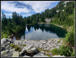
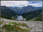
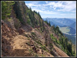
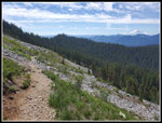
The grass and talus meadows along this section of the trail are a favorite of mine. With the early start, I was in no hurry. Some clouds were starting to come in but the views were mostly clear and beautiful. It is 5.25 miles to the Katwalk and another 1.25 to Ridge and Gravel Lakes. The trail descends to the saddle with the lakes on either side. I must have seen more than a dozen backpackers pass me heading out by this point. The lake could not be too crowded now. There were already some day hikers at Ridge Lake. I sat down for lunch at 10:30 am. Well, maybe brunch. Bugs had not been noticeable while hiking. They were when I sat down. With a long sleeve shirt on they were tolerable. At 10:48 I packed up and returned to the trail. I turned right and continued up the PCT. Within just a few minutes I was right above Alaska Lake. Alta Mountain sat right behind it on the other side of Gold Creek. This was my turnaround spot.
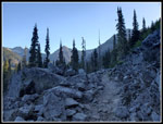
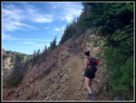
At 11:00 am I left Ridge Lake heading back. The long sleeve shirt did not last long. I put on the short sleeve shirt and slathered on more sunscreen. I was still not in a hurry. In addition the hordes were now here. I stepped off the trail a dozen times just getting back to the Katwalk. There were now half a dozen groups at the Katwalk. At 11:34 am I headed down. The crowds continued to come up the trail. Some groups were 7-8 people. The trail is so narrow with a long drop off the side that I just kept stopping and moved as far off the tread as possible. This was still a small price to pay for such a beautiful hike. I crossed the boulder field and was glad to move back into forest. It was already very toasty out in the sunshine. I stopped for another water break on the ridge top where I stopped on the way up.
The last four miles was mostly in cooler forest. The trail is a bit rocky but the grade is a steady 10%. About perfect for fast hiking. The last boulder field is all uphill. Out in the sun heading uphill on rocky terrain was challenging. Once back in forest the descent resumed and my speed picked up. I reached the trailhead at 2:07 pm. I just had one more hurdle this day. The 520 floating bridge was closed for the day. All cross Lake Washington traffic would be on I-90. To my surprise the slowdown was just the tunnel on Mercer Island and the floating bridge. It was much worse the day before when a car fire had three lanes closed. The downtown tunnel was slow too but much better than I-5. I was home by 3:30 pm.
I woke up planning a trail and boot path along a high ridge at Mt. Rainier and ended up with a 13 mile hike on the PCT with clear mountain views and lakes. We still need to get to the Mt. Rainier hike this summer. For the day I was pleased with my last minute alternate hike. This trip put me over 500 miles for the year for the 24th consecutive year. So far it has been a very good hiking year.
Click on thumbnails to get
larger pictures.
Trips - 2023
Home
The wildflower show is past prime at lower and higher elevations. I did still find smaller amounts of quite a few flowers in bloom. In the first half mile I saw several dark blue monkshood in bloom. I had not seen them in four or five years. It was 53 degrees when I started but it warmed up fast. I was forecast to reach the mid 70s in the afternoon. After about .70 miles I had to stop to switch into a short sleeve shirt and zip off my pants legs. It was humid enough that the change really cooled me off. I set a steady pace up the trail.
Where the trail descends through a rock field, I had great views of Guye Peak, Snoqualmie Mountain, Lundin Peak, and Red Mountain. The sky was blue and the sun was still very low in the sky. The lighting was great. I passed the junction with the Commonwealth Basin Trail and did not see the 4 km marker. I did see it on the way down. That put me almost half way to the Katwalk though I would be in forest for some time. I passed the one group that started ahead of me and began to see backpackers coming down. On the way up I passed five hikers and was passed by two runners. An early start provided quite a bit of solitude on a busy trail.
There are three big trees down on the trail. Two I had to crawl under. The biggest one is about 3.5 miles up near the ridge top. I took one break on the way up. The trail reaches the ridge top and a dry campsite. It then drops a bit and soon leaves the forest. I no sooner sat down when a camp robber jay joined me. As I started back to the trail a lone hiker went by. I followed her. We talked all the way up to the Katwalk, here turnaround spot. I picked up my pace to keep up and found I was hiking much faster than before.
We reached the open rocky slopes of Kendall Gardens and quickly had a view of Mt. Rainier. It was clear with no haze. Clearer than I have seen it in quite a while. There were wildflowers along here but not a lot. I saw some Indian paintbrush, asters, spirea, columbine, and a few others. As we turned the corner we went back into shade. I felt even better. Soon hikers would be out in the sunshine for much of the upper ascent. The trail turns to the north side of Kendall Peak and soon reaches the ridge top. There was not a bit of snow on or near the trail. We stopped for the views of Alta, Hibox, Three Queens, and Mt. Stuart. Two hikers got ahead of us. They were on the way to climb Mt. Thomson.
We arrived at the Katwalk at 9:40 am. After a few photos we headed across. At the north end I said goodbye to Casey (sp?). It was time to continue north. A little later I stopped and took my phone out of airplane mode. Just to confirm that there is no signal when surrounded by peaks. Except I did have a signal. In fact it showed 3 bars, just what I get at home in Seattle. I decided call Gary to check. He answered and we had a strong signal. He was not feeling any better and canceling our trip looked to be the right decision. After that I was able to upload a few photos. I have never had a signal beyond the Katwalk. From a safety standpoint, it was good to be able to call for help here if needed.
The grass and talus meadows along this section of the trail are a favorite of mine. With the early start, I was in no hurry. Some clouds were starting to come in but the views were mostly clear and beautiful. It is 5.25 miles to the Katwalk and another 1.25 to Ridge and Gravel Lakes. The trail descends to the saddle with the lakes on either side. I must have seen more than a dozen backpackers pass me heading out by this point. The lake could not be too crowded now. There were already some day hikers at Ridge Lake. I sat down for lunch at 10:30 am. Well, maybe brunch. Bugs had not been noticeable while hiking. They were when I sat down. With a long sleeve shirt on they were tolerable. At 10:48 I packed up and returned to the trail. I turned right and continued up the PCT. Within just a few minutes I was right above Alaska Lake. Alta Mountain sat right behind it on the other side of Gold Creek. This was my turnaround spot.
At 11:00 am I left Ridge Lake heading back. The long sleeve shirt did not last long. I put on the short sleeve shirt and slathered on more sunscreen. I was still not in a hurry. In addition the hordes were now here. I stepped off the trail a dozen times just getting back to the Katwalk. There were now half a dozen groups at the Katwalk. At 11:34 am I headed down. The crowds continued to come up the trail. Some groups were 7-8 people. The trail is so narrow with a long drop off the side that I just kept stopping and moved as far off the tread as possible. This was still a small price to pay for such a beautiful hike. I crossed the boulder field and was glad to move back into forest. It was already very toasty out in the sunshine. I stopped for another water break on the ridge top where I stopped on the way up.
The last four miles was mostly in cooler forest. The trail is a bit rocky but the grade is a steady 10%. About perfect for fast hiking. The last boulder field is all uphill. Out in the sun heading uphill on rocky terrain was challenging. Once back in forest the descent resumed and my speed picked up. I reached the trailhead at 2:07 pm. I just had one more hurdle this day. The 520 floating bridge was closed for the day. All cross Lake Washington traffic would be on I-90. To my surprise the slowdown was just the tunnel on Mercer Island and the floating bridge. It was much worse the day before when a car fire had three lanes closed. The downtown tunnel was slow too but much better than I-5. I was home by 3:30 pm.
I woke up planning a trail and boot path along a high ridge at Mt. Rainier and ended up with a 13 mile hike on the PCT with clear mountain views and lakes. We still need to get to the Mt. Rainier hike this summer. For the day I was pleased with my last minute alternate hike. This trip put me over 500 miles for the year for the 24th consecutive year. So far it has been a very good hiking year.
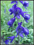 Monkshood |
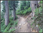 Well Graded Trail |
 Shaded Trail |
 Columbine |
 Guye Peak |
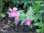 Lewis Monkey Flower |
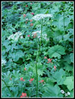
 Many Flowers |
 Paintbrush & Columbine |
 Paintbrush Close Up |
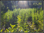 Sun Rays |
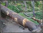 Biggest Log |
 Camp Robber Jay |
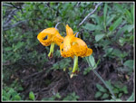 Tiger Lilies |
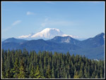 Mt. Rainier |
 Casey On PCT |
 Snoqualmie, Lundin, Red |
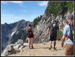 End Of Katwalk |
 Sub-Alpine |
 Sunlit Flowers |
 View Of Chikamin Peak |
 Cascade Crest Peaks |
 Overcoat & Chimney Rock |
 Mt. Thomson |
 Ridge Lake |
 Alaska Lake |
 View North |
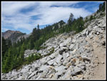 Crossing Talus Field |
 Alta Mountain |
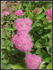 Rosy Spirea |
 View Of Katwalk |
 Framed Red Mountain |
 Descending Narrow Trail |
 Red Paintbrush |
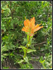 Orange Paintbrush |
 Bistort |
 Kendall Gardens |
 Red Mt. Again |
 Looking Back |
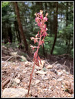 Coralroot |
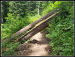 Another Big Log |
Trips - 2023
Home