05-07-23
I
was torn between a long flat wildflower hike near Cle Elum or a long
but less long hike much nearer with more than 2000' of gain. Going east
was much longer drive, and a forecast of wind gusts to the
low 20 mph level. Partly cloudy and cold with 20 mph wind was not
ideal. A chance to see balsamroot, lupine, Oregon anemone, woodland
star, and more was tempting. A loop trip on Tiger had the disadvantage
of a medium chance of rain all morning. Sunday morning things changed a
little . Still high wind for east of the crest but a very low chance of
rain west of the crest. I decided to return to a loop trip on Tiger I
did last year for the first time. I was on my way by 7:15 am. The
minuscule change of rain included having my wipers on for half the
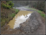
drive. I reached Tiger Summit to find I was in the clouds. It was misty
enough to feel like light rain. The parking lot was graded with new
gravel a couple years ago. Now there are numerous lakes to navigate
through to get to the road to the inner trailhead parking. That road
has plenty of potholes too. I arrived at the trailhead at 7:55 am. I
was packed and moving at 7:59 am. I carried my umbrella as I started in
a misty light drizzle. The parking lot was fuller than I can recall
this early in the morning. It was far from full, just more crowded than
usual.
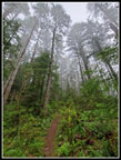
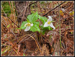
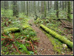
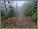
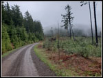
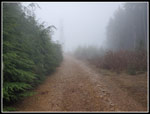
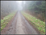
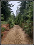
The forest caught much of the drizzle and a jacket was enough rain protection at first. As with my first time on this loop I did it clockwise, starting on the Iverson Trail. This trail is seldom used by bikes early in the morning. I figured I could likely make it to the hiker only trails ahead of most bikers. On the way down I could take the road which is plenty wide enough for hikers and bikers. It had clearly been raining for some time. There were many trillium in bloom and the flowers were weighted down by water. Part way along the Iverson Trail it skirts the edge of a recent clearcut. Some trees are left and in the fog they stood out in an almost black and white way. This made for some interesting photos. I saw a few yellow violets in bloom here too. I also saw a few blooming bleeding hearts. At the 1.5 mile mark I turned off on the Lower Side Hustle Trail. This is a fairly new trail. I found the upper end of it several years back before it was open. Last year I hiked it for the first time. This is shorter than the old route of dropping to the road at the end of the Iverson and hiking the road to the Tiger Mountain Trail (TMT).
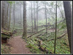
The Side Hustle is fairly short. After .30 miles I crossed a bridge and reached the next junction. The Side Hustle continues up as a biker downhill only trail. I would later see the upper junction. I took the TMT Connector Trail. This trail had some bed current bushes in full bloom. It crosses a logging road and continues to a new bridge crossing Holder Creek at the site of a 1925 railroad trail accident. Some parts of the trail are still there. I have visited this site for more than 30 years. It quickly reaches the TMT at 2.4 miles from Tiger Summit. The old TMT from here followed an old grassy roadbed. Since it was clearcut, a new TMT section has been built. This I first saw on last year's hike. It is shorter and goes from open clearcut to forest several times. It eventually meets up with the old TMT just before the Middle Tiger Trail. My gps map made it easy to spot the old trail. The Middle Tiger Trail comes up from below, crosses the TMT, and continues steeply up to the top of Middle Tiger Mountain.
At this point the mist and light drizzle became rain and I put up my umbrella. The trail ascends from 2100' to 2607' in .50 miles. A 1000'/mile grade is pretty steep. The ground was wet and a little slick and my pace was slow. I passed a runner with a dog just below the summit. I arrived on top at 9:52 am. I took 1:53 to hike 3.65 miles. It was a slow pace but I did stop for a lot of photos. The misty fog and bright wet moss made for moody photos. Just one week earlier I hiked up East Tiger from the other direction and it was 25 degrees warmer. Sunny and too hot. What a difference. I stopped for food and water on top. Digging in my pack while holding an umbrella. The hardest rain of the day was here. I started down the other side of Middle Tiger at 10:02 am.
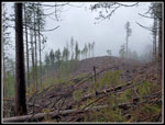
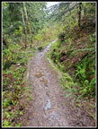
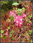
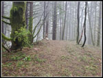
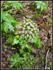
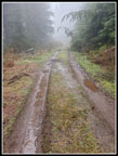
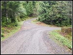
The trail down is very steep. I was very careful to stay upright. The descent is very short and steep. I was down in short order. A woman runner passed me near the bottom. The second person seen in just over 2 hours. The old super skinny gate is now gone. A newer very skinny gate is in place. I could just make it through this one. I was recalling before the logging was done from the main road to here. The old trail is no more and now the old gravel road is more dirt and grass than gravel. It is nearing trail status. Hiking along this section I saw a lot of blooming coltsfoot and several patches of yellow skunk cabbage. The view over to West Tiger 1 was completely lost in the clouds. I reached the main road from Tiger Summit to Tiger 1 and 2 summit towers. It is gated and only a few bikers seem to take it. I started up the steep road. After a short steep climb the grade moderates and a high point is reached. East Tiger is now ahead on the left but I could not see it at all. I reached the top of the Side Hustle Trail on the right and 30 or so feet farther is a trail on the left. This is the Preston Railroad Grade Trail. I passed the other end last weekend. The East Tiger Trail is also met just after the start. This is the short way up East Tiger. Since it is very narrow on a steep hillside I choose not to hike it. The road route is longer with more elevation gain. Just what I am after this day.
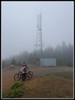
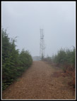
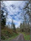
The road drops a little and reaches a major junction. Right is the route back to Tiger Summit and my car in about 2.8 miles. Straight is the route up East Tiger Mountain. It is a steep .50 miles to the summit spur road and then another .70 miles to the summit. From the major junction to the top is 1.2 miles with 611' of gain.. There are some very steep and some fairly flat sections. When I reached the summit spur junction I started seeing mountain bikers. Several sped by then several more. I was still feeling pretty good and sped up on the last .70 mile section. The clouds grew thicker the higher I went. I could not even see the tower until I was pretty close to it. I reached the top at 11:09 am. I had hiked about 6.7 miles to the top. That is exactly the distance I hiked from Highway 18 the week before. My route down this time would be only 4 miles. It was 6.7 last time. Last time I added a second trip down and up the summit spur. I was debating doing it again. After a quick food and water break I headed down at 11:17 am. Near the bottom I went over to the viewpoint as I had on the way up. Still zero views. I had stowed the umbrella after descending Middle Tiger. It did not come out again.
I calculated that I would be just short of 12 miles if I went back up and then down to the car. At the bottom of the summit spur I head up to the super steep biker downhill only Predator Trail and continued down the road. After just over .20 miles I turned around and hiked back up to the summit of East Tiger. The extra .40 miles would bring me up to 12 miles on the day. I arrived at the summit again at 11:52. I finished my lunch and talked with a biker. He had an electric bike and zoomed up the final spur. I headed down again at 11:58 am.
The trip down was much faster. I even had a few short bits of sunshine. It never lasted long. I saw a few bikes coming up on the road and one big group of about 10 who took up the whole road. The last connector trail to the parking lot has uphill. Just the way I seldom end a hike. I reached the now overflowing parking lot at 1:20. Coming down the last 4 miles in 1:23 was by far the fastest log of my loop hike. The lot was full and there were 7 or 8 more cars parked alongside the road.
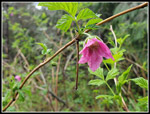
This was an interesting trip. The week before I finished at 79 degrees. This time it was 53 degrees. I had gloves on most of the day. The drizzle was persistent for the first half of the trip then ended. It was steady rain for a bout half and hour. The flower display was not enormous but I saw a lot of trillium, skunk cabbage, coltsfoot, and a few of at least half a dozen others.The first 6 miles I saw only two people. I saw many more the last 6 miles. There were long sections of solitude in the second half of the trip. At 12 miles with 2600' of elevation gain it was a good workout. This was my third straight trip of 12-15 miles in the last 8 days. It was a fun trip and I ended up with about 175 photos. That is well above average. A fun day on the trail.
Click on thumbnails to get
larger pictures.
Trips - 2023
Home
The forest caught much of the drizzle and a jacket was enough rain protection at first. As with my first time on this loop I did it clockwise, starting on the Iverson Trail. This trail is seldom used by bikes early in the morning. I figured I could likely make it to the hiker only trails ahead of most bikers. On the way down I could take the road which is plenty wide enough for hikers and bikers. It had clearly been raining for some time. There were many trillium in bloom and the flowers were weighted down by water. Part way along the Iverson Trail it skirts the edge of a recent clearcut. Some trees are left and in the fog they stood out in an almost black and white way. This made for some interesting photos. I saw a few yellow violets in bloom here too. I also saw a few blooming bleeding hearts. At the 1.5 mile mark I turned off on the Lower Side Hustle Trail. This is a fairly new trail. I found the upper end of it several years back before it was open. Last year I hiked it for the first time. This is shorter than the old route of dropping to the road at the end of the Iverson and hiking the road to the Tiger Mountain Trail (TMT).
The Side Hustle is fairly short. After .30 miles I crossed a bridge and reached the next junction. The Side Hustle continues up as a biker downhill only trail. I would later see the upper junction. I took the TMT Connector Trail. This trail had some bed current bushes in full bloom. It crosses a logging road and continues to a new bridge crossing Holder Creek at the site of a 1925 railroad trail accident. Some parts of the trail are still there. I have visited this site for more than 30 years. It quickly reaches the TMT at 2.4 miles from Tiger Summit. The old TMT from here followed an old grassy roadbed. Since it was clearcut, a new TMT section has been built. This I first saw on last year's hike. It is shorter and goes from open clearcut to forest several times. It eventually meets up with the old TMT just before the Middle Tiger Trail. My gps map made it easy to spot the old trail. The Middle Tiger Trail comes up from below, crosses the TMT, and continues steeply up to the top of Middle Tiger Mountain.
At this point the mist and light drizzle became rain and I put up my umbrella. The trail ascends from 2100' to 2607' in .50 miles. A 1000'/mile grade is pretty steep. The ground was wet and a little slick and my pace was slow. I passed a runner with a dog just below the summit. I arrived on top at 9:52 am. I took 1:53 to hike 3.65 miles. It was a slow pace but I did stop for a lot of photos. The misty fog and bright wet moss made for moody photos. Just one week earlier I hiked up East Tiger from the other direction and it was 25 degrees warmer. Sunny and too hot. What a difference. I stopped for food and water on top. Digging in my pack while holding an umbrella. The hardest rain of the day was here. I started down the other side of Middle Tiger at 10:02 am.
The trail down is very steep. I was very careful to stay upright. The descent is very short and steep. I was down in short order. A woman runner passed me near the bottom. The second person seen in just over 2 hours. The old super skinny gate is now gone. A newer very skinny gate is in place. I could just make it through this one. I was recalling before the logging was done from the main road to here. The old trail is no more and now the old gravel road is more dirt and grass than gravel. It is nearing trail status. Hiking along this section I saw a lot of blooming coltsfoot and several patches of yellow skunk cabbage. The view over to West Tiger 1 was completely lost in the clouds. I reached the main road from Tiger Summit to Tiger 1 and 2 summit towers. It is gated and only a few bikers seem to take it. I started up the steep road. After a short steep climb the grade moderates and a high point is reached. East Tiger is now ahead on the left but I could not see it at all. I reached the top of the Side Hustle Trail on the right and 30 or so feet farther is a trail on the left. This is the Preston Railroad Grade Trail. I passed the other end last weekend. The East Tiger Trail is also met just after the start. This is the short way up East Tiger. Since it is very narrow on a steep hillside I choose not to hike it. The road route is longer with more elevation gain. Just what I am after this day.
The road drops a little and reaches a major junction. Right is the route back to Tiger Summit and my car in about 2.8 miles. Straight is the route up East Tiger Mountain. It is a steep .50 miles to the summit spur road and then another .70 miles to the summit. From the major junction to the top is 1.2 miles with 611' of gain.. There are some very steep and some fairly flat sections. When I reached the summit spur junction I started seeing mountain bikers. Several sped by then several more. I was still feeling pretty good and sped up on the last .70 mile section. The clouds grew thicker the higher I went. I could not even see the tower until I was pretty close to it. I reached the top at 11:09 am. I had hiked about 6.7 miles to the top. That is exactly the distance I hiked from Highway 18 the week before. My route down this time would be only 4 miles. It was 6.7 last time. Last time I added a second trip down and up the summit spur. I was debating doing it again. After a quick food and water break I headed down at 11:17 am. Near the bottom I went over to the viewpoint as I had on the way up. Still zero views. I had stowed the umbrella after descending Middle Tiger. It did not come out again.
I calculated that I would be just short of 12 miles if I went back up and then down to the car. At the bottom of the summit spur I head up to the super steep biker downhill only Predator Trail and continued down the road. After just over .20 miles I turned around and hiked back up to the summit of East Tiger. The extra .40 miles would bring me up to 12 miles on the day. I arrived at the summit again at 11:52. I finished my lunch and talked with a biker. He had an electric bike and zoomed up the final spur. I headed down again at 11:58 am.
The trip down was much faster. I even had a few short bits of sunshine. It never lasted long. I saw a few bikes coming up on the road and one big group of about 10 who took up the whole road. The last connector trail to the parking lot has uphill. Just the way I seldom end a hike. I reached the now overflowing parking lot at 1:20. Coming down the last 4 miles in 1:23 was by far the fastest log of my loop hike. The lot was full and there were 7 or 8 more cars parked alongside the road.
This was an interesting trip. The week before I finished at 79 degrees. This time it was 53 degrees. I had gloves on most of the day. The drizzle was persistent for the first half of the trip then ended. It was steady rain for a bout half and hour. The flower display was not enormous but I saw a lot of trillium, skunk cabbage, coltsfoot, and a few of at least half a dozen others.The first 6 miles I saw only two people. I saw many more the last 6 miles. There were long sections of solitude in the second half of the trip. At 12 miles with 2600' of elevation gain it was a good workout. This was my third straight trip of 12-15 miles in the last 8 days. It was a fun trip and I ended up with about 175 photos. That is well above average. A fun day on the trail.
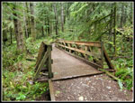 Iverson Trail Bridge |
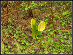
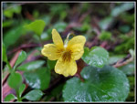 Yellow Violet |
 Misty Forest |
 Misty Trees |
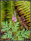 Bleeding Hearts |
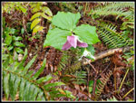 Pink & White Trillium |
 Wet Trail |
 Slide Hustle Trail |
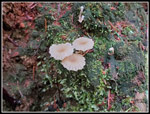
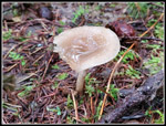 Wet Mushroom |
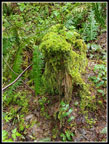 Mossy Stump |
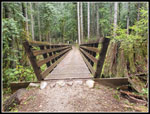 Bike Bridge |
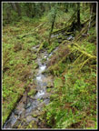 Small Creek |
 Tiny Mushrooms |
 Trees & Sky |
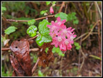 Red Currants |
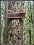 Train Wreck |
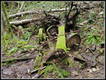 Train Parts |
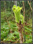 Devil's Club |
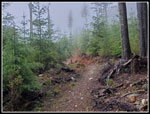 Misty TMT |
 More Red Currants |
 Twin Trilliums |
 Middle Tiger Trail |
 Middle Tiger Summit |
 Coltsfoot Close Up |
 Old Logging Road |
 Skunk Cabbage |
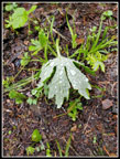 Soaking Wet Leaf |
 Getting Wetter |
 Main Tiger Road |
 Big Junction |
 East Tiger Lake |
 Viewpoint? |
 Cloudy Summit |
 Bikers |
 Coltsfoot Borders |
 Second Summit |
 Shadows! |
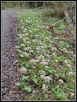 Lots Of Coltsfoot |
 Blue Sky! |
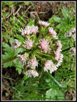
 Salmonberry Flower |
 Another Coltsfoot |
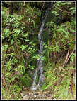 Waterfall |
Trips - 2023
Home