10-21-23
I
needed a Saturday hike close in.
With rain in the afternoon I wanted an early start. That would give me
time for at least 10 miles. I was out the door at 6:30 am. I stopped
for cheap Issaquah gas (only $4.60) and reached the Tiger Summit inner
trailhead at 7:20 am. I was on the trail at 7:24 am. Nearly the entire
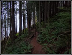
drive was in the dark. It was dim but not dark when I headed out. I
first did this loop for the first time on 5-07-23. I may have done it
in the past via the Iverson Trail to the road then up the TMT to Middle
Tiger. This new route is shorter taking a new trail from the Iverson to
the TMT. The TMT itself has been shortened after this trail meets it.
At the start it was too dark for good photos. My phone has a feature to
keep the screen dark when in a pocket. This day it felt the day was too
dark and refused to let me open the phone to get to my camera. When It
was light enough to work, I disabled this feature. The mushroom show
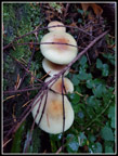
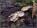
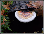
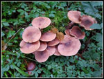
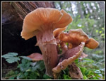
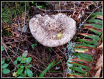
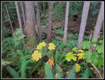
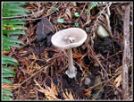
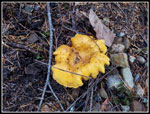
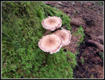
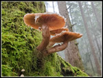
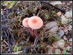
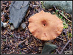
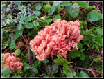
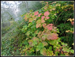
began early but was muted. Some here and there but no big displays.
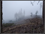
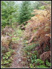
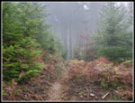
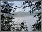
Later on, I would find more mushrooms. The day was misty and very misty
when I reached a clearcut. The trees were visible but a white mist
filled the view. It was actually kind of neat. Within about
20 minutes It was light out but still misty. It looked like a moist day
of hiking.
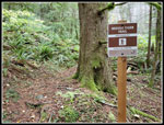
I reached the junction with the Side Hustle Trail and took it. This is a one way down bike trail but the first part is open to hikers in both directions. When I reached the junction with the TMT Connector Trail the Side Hustle became bikes downhill only. Later, I would pass the top of the Side Hustle Trail. Recent rain made for wet brush. That was not a problem for most of the trail. Parts of the TMT Connector are a bit brushy. My pants became a little wet and my feet were no longer dry. The Connector ends up at the end of the 1925 trail wreck site. The new trail drops down to the site and a new bridge crossed the creek. I have a lot of photos of the few remaining parts form the wreck. I added more this day.
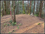
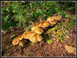
I was quickly on the TMT (Tiger Mt. Trail). Right at that point the old trail made a big semi-circle. The new section goes straight ahead. It is much shorter now. The trail is near the edge of the recent clearcut. The mushroom show improved noticeably. I stopped for quite a few photos as my average speed plummeted. It was well worth the time. The trail enters dark forest and passes the spot where the old TMT comes in. Using my gps I could see where it used to be but could not be sure where the old trail is. It seems to be well hidden by the new trail builders. Just a few minutes later I reached the Middle Tiger Trail. I turned right and began the steep ascent. This trail has some quite steep sections and some more gentle switchbacks. I think it was been moderated as I seem to recall the whole trail being very steep years ago. Though it was a cold 50 degrees at the start, it seemed to be much warmer now. It also seemed to be lighter. I finally reached the 2608' summit of Middle Tiger Mountain at 9:16 am. I hiked 4 miles in 1:52. I had an early brunch and I was heading down at 9:24 am. The drop is steep and there is a big log across the trail. It was not too bad getting over it. At the summit I was in trees but there were shadows. For a moment I was above the clouds. That was not in the forecast.
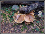
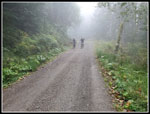
At the bottom of the road I could barely see the top of Tiger 1 through a row if deciduous trees. The summit was in the clear but there were white clouds below. I was not on an old logging road and it continued to drop slowly. I was then right back in the misty clouds. It was markedly colder in the clouds. I found some more mushrooms along here. The road bottomed and climbed slightly to reach the main Tiger Road that goes up Tiger 1 and 2. I turned right and the road began to climb at a steeper grade. As the road topped out, I was back out in sunshine. The sun was still low and I only had it in clearcuts. Looking back, it was too cloudy to see to Middle Tiger. Normally, I would have a window where East Tiger comes into view. It was too cloudy at this time. Thus far I had total solitude. Most bikers climb straight up East Tiger on the road or the Master Link Trail. I'm sure some come down the one way Side Hustle Trail but few seem to start up the Iverson. I did this loop clockwise to avoid crowds. It worked very well. I passed the top of the Side Hustle and the road began to descend. I passed the Preston RR Grade Trail. A branch off of it goes up East Tiger. It is very narrow on a steep slope and not a good place for hikers to meet bikers. I prefer the longer road route up.
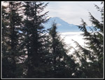
The road bottomed out where my downhill route comes in. This direct road starts about 2.8 miles downhill at Tiger Summit. Now I had a steady climb up as I continued contouring around East Tiger. At the next junction the East Tiger summit spur goes off to the left. Now I started to see bikers. Multiple groups passed by. The last .70 miles to the summit is a good workout. There are a couple flat spots and a few really steep sections for a road. My pace actually picked up as I headed for the top. I reached the summit at 10:33 am. I had traveled 6.8 miles. The base loop is 10 miles with 2200' of gain. The weather was good so I decided to do the summit spur twice. It brings the day up to 12 miles with 2600' of gain. Speaking of good weather, above the summit the sky was bright blue. Mt. Rainier was clear though a small cloud cap was forming. Below me was a sea of white. All around the low clouds never did burn off. I was in sunshine at 3000' but below about 2100' was a dense misty fog. I love looking down on the tops of clouds. This was not forecast and definitely not expected. I love to grab sunshine on a day when most people are home in the moist mist.
After a short food and water break I headed down the road. More bikes were coming up. At the bottom I continued straight ahead over to the top of the Predator Trail and beyond. By adding an extra .30 miles I would round up to an even 12 miles for the day. I headed back and then up the summit spur a second time. It is hard to keep up the pace for the second climb but I did pretty well. I reached the top for the second time at 11:16 am. It was even warmer now. At least it felt that way in direct sunlight. My stay was short and at 11:24 am I headed down once again. It is about 4 miles from the summit to the trailhead. It is nearly all downhill. The road is plenty wide enough for multiple bikes to pass a hiker. It was pretty easy hiking. The road is hard and by the end I am wishing I was on soft trail but the road is easier than going down the Master Link by afternoon as many bikers are coming up it. The descent went pretty quickly. I raised my average moving speed from 2.1 to 2.4 mph in just the last third of the hike. Without mushrooms to stop and photograph my speed picked up a lot.
I arrived back at my car at 12:34 pm. I took 5:10 to hike the 12 miles. It was still not long past noon. The parking lot was overflowing as expected. Cars were parked along the road. My early start allowed me to get in a long trip and get through Seattle before the Seahawks crowd bogged down the freeway. This is a fun loop with two summits and few people for the first half of the trip. In the spring I had wildflowers and in the fall it was mushrooms. Best of all I hiked above the clouds and into sunshine. All in all, not a bad day for a fall hike.
Click on thumbnails to get
larger pictures.
Trips - 2023
Home
I reached the junction with the Side Hustle Trail and took it. This is a one way down bike trail but the first part is open to hikers in both directions. When I reached the junction with the TMT Connector Trail the Side Hustle became bikes downhill only. Later, I would pass the top of the Side Hustle Trail. Recent rain made for wet brush. That was not a problem for most of the trail. Parts of the TMT Connector are a bit brushy. My pants became a little wet and my feet were no longer dry. The Connector ends up at the end of the 1925 trail wreck site. The new trail drops down to the site and a new bridge crossed the creek. I have a lot of photos of the few remaining parts form the wreck. I added more this day.
I was quickly on the TMT (Tiger Mt. Trail). Right at that point the old trail made a big semi-circle. The new section goes straight ahead. It is much shorter now. The trail is near the edge of the recent clearcut. The mushroom show improved noticeably. I stopped for quite a few photos as my average speed plummeted. It was well worth the time. The trail enters dark forest and passes the spot where the old TMT comes in. Using my gps I could see where it used to be but could not be sure where the old trail is. It seems to be well hidden by the new trail builders. Just a few minutes later I reached the Middle Tiger Trail. I turned right and began the steep ascent. This trail has some quite steep sections and some more gentle switchbacks. I think it was been moderated as I seem to recall the whole trail being very steep years ago. Though it was a cold 50 degrees at the start, it seemed to be much warmer now. It also seemed to be lighter. I finally reached the 2608' summit of Middle Tiger Mountain at 9:16 am. I hiked 4 miles in 1:52. I had an early brunch and I was heading down at 9:24 am. The drop is steep and there is a big log across the trail. It was not too bad getting over it. At the summit I was in trees but there were shadows. For a moment I was above the clouds. That was not in the forecast.
At the bottom of the road I could barely see the top of Tiger 1 through a row if deciduous trees. The summit was in the clear but there were white clouds below. I was not on an old logging road and it continued to drop slowly. I was then right back in the misty clouds. It was markedly colder in the clouds. I found some more mushrooms along here. The road bottomed and climbed slightly to reach the main Tiger Road that goes up Tiger 1 and 2. I turned right and the road began to climb at a steeper grade. As the road topped out, I was back out in sunshine. The sun was still low and I only had it in clearcuts. Looking back, it was too cloudy to see to Middle Tiger. Normally, I would have a window where East Tiger comes into view. It was too cloudy at this time. Thus far I had total solitude. Most bikers climb straight up East Tiger on the road or the Master Link Trail. I'm sure some come down the one way Side Hustle Trail but few seem to start up the Iverson. I did this loop clockwise to avoid crowds. It worked very well. I passed the top of the Side Hustle and the road began to descend. I passed the Preston RR Grade Trail. A branch off of it goes up East Tiger. It is very narrow on a steep slope and not a good place for hikers to meet bikers. I prefer the longer road route up.
The road bottomed out where my downhill route comes in. This direct road starts about 2.8 miles downhill at Tiger Summit. Now I had a steady climb up as I continued contouring around East Tiger. At the next junction the East Tiger summit spur goes off to the left. Now I started to see bikers. Multiple groups passed by. The last .70 miles to the summit is a good workout. There are a couple flat spots and a few really steep sections for a road. My pace actually picked up as I headed for the top. I reached the summit at 10:33 am. I had traveled 6.8 miles. The base loop is 10 miles with 2200' of gain. The weather was good so I decided to do the summit spur twice. It brings the day up to 12 miles with 2600' of gain. Speaking of good weather, above the summit the sky was bright blue. Mt. Rainier was clear though a small cloud cap was forming. Below me was a sea of white. All around the low clouds never did burn off. I was in sunshine at 3000' but below about 2100' was a dense misty fog. I love looking down on the tops of clouds. This was not forecast and definitely not expected. I love to grab sunshine on a day when most people are home in the moist mist.
After a short food and water break I headed down the road. More bikes were coming up. At the bottom I continued straight ahead over to the top of the Predator Trail and beyond. By adding an extra .30 miles I would round up to an even 12 miles for the day. I headed back and then up the summit spur a second time. It is hard to keep up the pace for the second climb but I did pretty well. I reached the top for the second time at 11:16 am. It was even warmer now. At least it felt that way in direct sunlight. My stay was short and at 11:24 am I headed down once again. It is about 4 miles from the summit to the trailhead. It is nearly all downhill. The road is plenty wide enough for multiple bikes to pass a hiker. It was pretty easy hiking. The road is hard and by the end I am wishing I was on soft trail but the road is easier than going down the Master Link by afternoon as many bikers are coming up it. The descent went pretty quickly. I raised my average moving speed from 2.1 to 2.4 mph in just the last third of the hike. Without mushrooms to stop and photograph my speed picked up a lot.
I arrived back at my car at 12:34 pm. I took 5:10 to hike the 12 miles. It was still not long past noon. The parking lot was overflowing as expected. Cars were parked along the road. My early start allowed me to get in a long trip and get through Seattle before the Seahawks crowd bogged down the freeway. This is a fun loop with two summits and few people for the first half of the trip. In the spring I had wildflowers and in the fall it was mushrooms. Best of all I hiked above the clouds and into sunshine. All in all, not a bad day for a fall hike.
 Dark Forest At First |
 Misty Clearcut |
 Angry Squirrel |
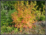
 First Fall Color |
 First Mushroom Shot |
 More Mushrooms |
 Shiny Shrooms |
 Dark Background |
 Nice Color |
 View from Beneath |
 Wet Strawberry? |
 Big Mushroom |
 A Little Brushy |
 New Bridge |
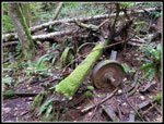 Train Wreck |
 Line White Mushroom |
 On The TMT |
 Great Color |
 Mossy Background |
 My Favorite Trip Photo |
 Mushroom Duo |
 A Hole In The Middle |
 Middle Tiger Trail |
 Great Color |
 Middle Tiger Summit |
 Descent Into Clouds |
 Tiger 1 Over Clouds |
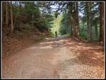
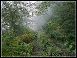 Road/Trail |
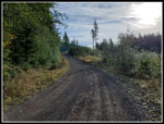 Into Sunshine |
 Sunlit Leaves |
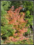 Best Color |
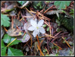
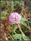 Clover |
 On East Tiger Spur |
 Mt. Rainier |
 Sun On Mushrooms |
 Above The Clouds |
 Back In The Clouds |
Trips - 2023
Home