07-22-23
Gary
Westerlund and John Sluder joined me for a fun hike at Mt. Rainier. I
did this trip to Palisades Lake then up to Brown Peak and on along the
ridge top in 2018 for the first time. Gary and John like ridge walks so
I thought this would be enjoyed by all of us. I was on the road at 5:45
am. I met Gary at 6:45 am and he drove to pick up John. We drove up
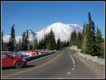
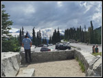
Highway 410 to the Sunrise entrance to the park and then to Sunrise
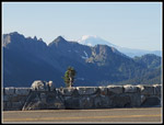
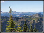
Point at 6120". We arrived under blue sky at 7:56 am. Great views of
Mt. Rainier, Mt. Adams, and many other peaks. We were on our way at
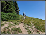
8:05 am. Unlike most hikes, this one starts with a steep descent and so
finishes with a steep ascent. We dropped down 480' quickly. Along the
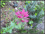
way we saw some magenta Indian paintbrush, lupine, and other
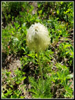
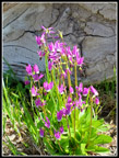
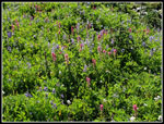
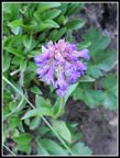
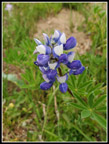
wildflowers in bloom. Not a great display but good one.
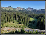
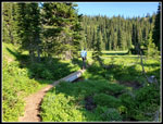
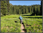
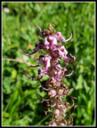
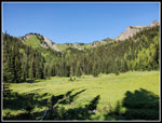
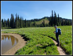
The route is mostly in forest for the first three miles. The forest was broken up by lush green meadows and several lakes. At the end of the road, a couple miles beyond Sunrise Point, is a big parking lot at Sunrise. It has trails to great views of Mt. Rainier. Sunrise Point is mostly for cars to stop and people to get great mountain views. There are hikers on trails leaving the Point but not the crowds of Sunrise itself. After about 1.5 miles, we reached Clover Lake. It was still only 8:45 am and the sunshine felt good. There was a good display of wildflowers near the lake. In addition to the magenta paintbrush and lupine, we saw some Elephanthead lousewort, western anemone, penstemon, and false hellebore, After 2.25 hours of driving and 41 minutes of hiking, I was ready for some food and water.
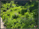
After our break we continued on. Just beyond the lake the trail climbs steeply to a pass and drops down steeply on the other side. This was the second largest climb on the way out. We then dropped down to more meadows. We saw one lone tiger lily early and columbine in a few places. I did not take a photo of the tiger lilies and the few columbine shots I took were not well focused. I expected to see more but it was not to be. At 2.6 miles we reached the turnoff for Hidden Lake. John had done that and scrambled up above but not been to Palisades Lakes. Next came the turnoff for Dick's Lake.
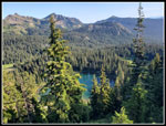
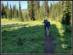
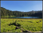
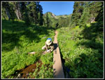
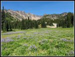
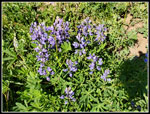
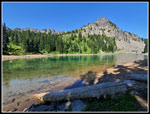
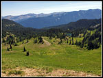
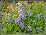
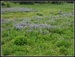
After Dick's Lake we soon entered the big meadow. There was a lot of lupine in bloom. Bistort was mixed in with it. The pond was already low. tadpoles were all along near the edge. Bird's beak lousewort was seen on much of the trip. There was a lot of it in the big meadow. The Palisades Peaks were right behind the meadow. We could now see the ridge of Brown Peak we would soon be ascending. We climbed a bit and reached the unsigned junction with the Brown Peak boot path. We continued down to Upper Palisades Lake. There were more wildflowers near the lake. We had hiked 3.5 miles to the lake. A short trail took us down to lake level. The lake was well below the full level. Walking along the rocky lake bed we saw a very colorful patch of shooting stars. The color was a brighter purple than I usually see.
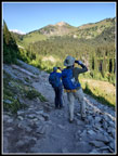
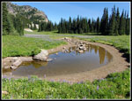
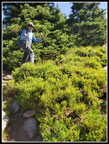
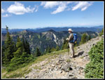
There were two hikers in the shade on the short. We passed by to another shady spot for our brunch. It was still only 10:04 am. With many photo stops we took two hours to hike the 3.5 miles. With an early start we were in no hurry. I noticed a salamander near shore. The water was very clear. John managed to get a good photo of it. The forecast was for a high at this elevation of 63 degrees in the afternoon. It already felt warmer than that in the sunshine. After our break, we packed up and headed back to the junction for Brown Peak. The boot path up is very steep in places and has some loose rock and dirt. Not hard but not a real trail either. As we ascended the views improved rapidly. We could son see Mt. Adams and the Cowlitz Chimneys. The top of Mt. Rainier came into view too. The mountain was crystal clear at the start of our hike. The top now had a partial cloud layer. The saying is that the mountain makes its own weather. We had a good example of that this day.
The summit of Brown Peak is completely forested. We all went to the highest point. On my first visit, we took a very steep path down the ridge from the summit. On the way back we saw a path going to the left of the ridge. We took that and it was narrow on the side of the hill but longer and less steep. I tried to descend my previous uphill return and made a slight error. The path down started well but then just ended. Below we could see a trail. Oh well... we walked, slid, and but scooted down to the trail. After that it was a breeze going over tot he junction with the straight down trail. On our ascent of Brown Peak we saw a hiker coming down. Now that we were on the ridge below Brown Peak we saw another hiker coming toward us. He said he saw two other hikers on the ridge. On my previous visit we saw nobody on the ridge.
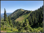
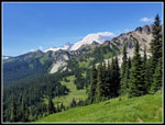
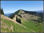
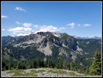
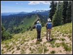
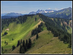
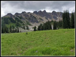
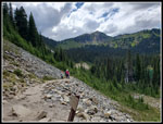
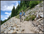
Now came the best part of the day. the ridge is very narrow at first. It slopes steeply down on both sides. The Palisades and a high ridge was to our left. To our right was a big green meadow with a lake in it. This is the scenery we hike to see. The ridge continued on and the lower Palisades Lake came into view. In places the smell of elk was overpowering. They bed down on places on the ridge where it widens. The flattened grass showed us where. The ridge then begins to climb. It steepens before the grade lessens. The ascent is from 6150' to about 6500'. On this summit we found some trees and shade. It was time for lunch at 11:40 am. A lone woman hiker passed through and continued on.
At 12:00 pm we decided to go on. I recalled going to one more summit on the ridge in 2018. The path was easy to follow as it dropped to another saddle and climbed up the other side. It looked like we were below the summit where we stopped last time. The trail kept going on. We soon saw the lone hiker who passed us sitting down on the hillside. We went up to the ridge top and consulted the map. We were on South Slide Mountain. Ahead was another drop and a peak blocking Slide Mountain farther down the ridge. It was sunny and hot and Slide is lower than South Slide. We chose to head back along the ridge to the high point and call it a day. We than saw the hiker heading farther on the ridge. She followed a path that was descending the hillside to the right of the next bump. We had no idea where she was going. We quickly went up to the top.
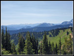
South Slide Mountain was the point where we turned around in 2018. We arrived at 12:25 pm. We had views in all directions from this summit. Clouds were now forming over us though we remained in the sunshine. Away from Mt. Rainier it was all blue sky. The summit of Rainier was now more covered by clouds. We could see buildings across the White River Valley atop the Crystal Mountain Ski Area. In the opposite directions we could just make out Mt. Fremont Lookout near Sunrise. Grand Park was also clearly seen. At 6620' this was our high point of the day. Surprisingly, it was only 500' above the trailhead parking lot.
At 1:20 pm we headed back. More ridge walking as we retraced our steps back to Brown Peak. We noticed a lot of something in Lower Palisades Lake. It was not there in the morning. Wind must have pushed across the lake. We took some photos but have no idea what it was. Back at the base of Brown Peak we took the route to the left that we had come down. This time we followed the trail all the way to the far ridge. This is the way we should have come down earlier. We then dropped back down to the main trail. I took more photos as we crossed the big meadow. Clouds had changed the lighting a lot. The climb up to the pass before reaching Clover Lake was steep and in the humid hot afternoon it was not much fun. We did take another photo break at Clover Lake.
The last 1.5 miles dragged on until we started the last climb to Sunrise Point. It was just as steep as I recalled it. We were glad to be back at the trailhead. Rainier was now mostly in the big cloud. Only the base could be seen. For a Saturday in July the drive home was easy. Perhaps a sold out baseball game, a WNBA game, and a big Taylor Swift concert at the Football stadium had an impact on crowding on the road.
This is a great hike. Flowers, meadows, lakes, and then a ridge top walk at over 6000'. All of this right next to a 14,411 volcano. What's not to like. It is a long drive from North Seattle but well worth the effort. I expect I will be back to hike it again in the not too distant future.
Click on thumbnails to get
larger pictures.
Trips - 2023
Home
The route is mostly in forest for the first three miles. The forest was broken up by lush green meadows and several lakes. At the end of the road, a couple miles beyond Sunrise Point, is a big parking lot at Sunrise. It has trails to great views of Mt. Rainier. Sunrise Point is mostly for cars to stop and people to get great mountain views. There are hikers on trails leaving the Point but not the crowds of Sunrise itself. After about 1.5 miles, we reached Clover Lake. It was still only 8:45 am and the sunshine felt good. There was a good display of wildflowers near the lake. In addition to the magenta paintbrush and lupine, we saw some Elephanthead lousewort, western anemone, penstemon, and false hellebore, After 2.25 hours of driving and 41 minutes of hiking, I was ready for some food and water.
After our break we continued on. Just beyond the lake the trail climbs steeply to a pass and drops down steeply on the other side. This was the second largest climb on the way out. We then dropped down to more meadows. We saw one lone tiger lily early and columbine in a few places. I did not take a photo of the tiger lilies and the few columbine shots I took were not well focused. I expected to see more but it was not to be. At 2.6 miles we reached the turnoff for Hidden Lake. John had done that and scrambled up above but not been to Palisades Lakes. Next came the turnoff for Dick's Lake.
After Dick's Lake we soon entered the big meadow. There was a lot of lupine in bloom. Bistort was mixed in with it. The pond was already low. tadpoles were all along near the edge. Bird's beak lousewort was seen on much of the trip. There was a lot of it in the big meadow. The Palisades Peaks were right behind the meadow. We could now see the ridge of Brown Peak we would soon be ascending. We climbed a bit and reached the unsigned junction with the Brown Peak boot path. We continued down to Upper Palisades Lake. There were more wildflowers near the lake. We had hiked 3.5 miles to the lake. A short trail took us down to lake level. The lake was well below the full level. Walking along the rocky lake bed we saw a very colorful patch of shooting stars. The color was a brighter purple than I usually see.
There were two hikers in the shade on the short. We passed by to another shady spot for our brunch. It was still only 10:04 am. With many photo stops we took two hours to hike the 3.5 miles. With an early start we were in no hurry. I noticed a salamander near shore. The water was very clear. John managed to get a good photo of it. The forecast was for a high at this elevation of 63 degrees in the afternoon. It already felt warmer than that in the sunshine. After our break, we packed up and headed back to the junction for Brown Peak. The boot path up is very steep in places and has some loose rock and dirt. Not hard but not a real trail either. As we ascended the views improved rapidly. We could son see Mt. Adams and the Cowlitz Chimneys. The top of Mt. Rainier came into view too. The mountain was crystal clear at the start of our hike. The top now had a partial cloud layer. The saying is that the mountain makes its own weather. We had a good example of that this day.
The summit of Brown Peak is completely forested. We all went to the highest point. On my first visit, we took a very steep path down the ridge from the summit. On the way back we saw a path going to the left of the ridge. We took that and it was narrow on the side of the hill but longer and less steep. I tried to descend my previous uphill return and made a slight error. The path down started well but then just ended. Below we could see a trail. Oh well... we walked, slid, and but scooted down to the trail. After that it was a breeze going over tot he junction with the straight down trail. On our ascent of Brown Peak we saw a hiker coming down. Now that we were on the ridge below Brown Peak we saw another hiker coming toward us. He said he saw two other hikers on the ridge. On my previous visit we saw nobody on the ridge.
Now came the best part of the day. the ridge is very narrow at first. It slopes steeply down on both sides. The Palisades and a high ridge was to our left. To our right was a big green meadow with a lake in it. This is the scenery we hike to see. The ridge continued on and the lower Palisades Lake came into view. In places the smell of elk was overpowering. They bed down on places on the ridge where it widens. The flattened grass showed us where. The ridge then begins to climb. It steepens before the grade lessens. The ascent is from 6150' to about 6500'. On this summit we found some trees and shade. It was time for lunch at 11:40 am. A lone woman hiker passed through and continued on.
At 12:00 pm we decided to go on. I recalled going to one more summit on the ridge in 2018. The path was easy to follow as it dropped to another saddle and climbed up the other side. It looked like we were below the summit where we stopped last time. The trail kept going on. We soon saw the lone hiker who passed us sitting down on the hillside. We went up to the ridge top and consulted the map. We were on South Slide Mountain. Ahead was another drop and a peak blocking Slide Mountain farther down the ridge. It was sunny and hot and Slide is lower than South Slide. We chose to head back along the ridge to the high point and call it a day. We than saw the hiker heading farther on the ridge. She followed a path that was descending the hillside to the right of the next bump. We had no idea where she was going. We quickly went up to the top.
South Slide Mountain was the point where we turned around in 2018. We arrived at 12:25 pm. We had views in all directions from this summit. Clouds were now forming over us though we remained in the sunshine. Away from Mt. Rainier it was all blue sky. The summit of Rainier was now more covered by clouds. We could see buildings across the White River Valley atop the Crystal Mountain Ski Area. In the opposite directions we could just make out Mt. Fremont Lookout near Sunrise. Grand Park was also clearly seen. At 6620' this was our high point of the day. Surprisingly, it was only 500' above the trailhead parking lot.
At 1:20 pm we headed back. More ridge walking as we retraced our steps back to Brown Peak. We noticed a lot of something in Lower Palisades Lake. It was not there in the morning. Wind must have pushed across the lake. We took some photos but have no idea what it was. Back at the base of Brown Peak we took the route to the left that we had come down. This time we followed the trail all the way to the far ridge. This is the way we should have come down earlier. We then dropped back down to the main trail. I took more photos as we crossed the big meadow. Clouds had changed the lighting a lot. The climb up to the pass before reaching Clover Lake was steep and in the humid hot afternoon it was not much fun. We did take another photo break at Clover Lake.
The last 1.5 miles dragged on until we started the last climb to Sunrise Point. It was just as steep as I recalled it. We were glad to be back at the trailhead. Rainier was now mostly in the big cloud. Only the base could be seen. For a Saturday in July the drive home was easy. Perhaps a sold out baseball game, a WNBA game, and a big Taylor Swift concert at the Football stadium had an impact on crowding on the road.
This is a great hike. Flowers, meadows, lakes, and then a ridge top walk at over 6000'. All of this right next to a 14,411 volcano. What's not to like. It is a long drive from North Seattle but well worth the effort. I expect I will be back to hike it again in the not too distant future.
 Mt. Adams From Start |
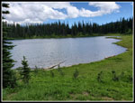
 Sunrise Lake |
 Mt. Rainier From Start |
 Magenta Indian Paintbrush |
 Meadow Below |
 Shade On Descent |
 Few Flowers At First |
 Clover Lake |
 More Meadows |
 Gary At Work |
 Elephanthead Lousewort |
 Western Anemone |
 Shadows |
 More Flowers |
 John At Work |
 Pond In Big Meadow |
 Gary In Meadow |
 Big Meadow |
 Lupine |
 Aster |
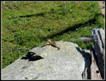 Ground Squirrel |
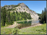 Upper Palisades Lake |
 Shooting Stars |
 Break At Lake |
 Flower Bouquet |
 Ascending Boot Path |
 Ridge In Sight |
 Rainier In Sight |
 Nearing Ridge |
 Penstemon |
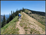 Guys On Ridge |
 Meadow & Lake Below |
 Heading Higher |
 Cloudy Mt. Rainier |
 Goat Rocks & Adams |
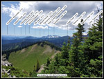 Named Peaks |
 Grand Park |
 John On Ridge |
 Looking At Brown Peak |
 Good Lighting |
 Clouds Over Palisades |
 Blue & White Lupine |
 Lupine Again |
 Lupine & Bistort |
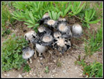 Mushrooms |
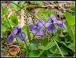 Violets |
 Clover Lake Again |
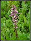 Another Elephanthead |
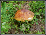 Big Mushroom |
 Last Uphill |
 Gary & John |
 Rainier In Clouds |
Trips - 2023
Home