12-28-23
With
only four days left in the year, Gary joined me for a hike on Tiger
Mountain. With a furious fourth quarter, I was closing in on some
improbable long term goals. I needed just 7 miles to reach 1000 for
only the third time in 40 years. The first time was 31 years ago and
the second was last year. I was well in reach of my second best year
ever. My second best elevation gain year was 254,400'. I needed just
7,100' to reach that position. I needed a strenuous day to go over 1000
miles and near my elevation goal. I did not hike the first eight days
of the month and then hiked nine of the next eighteen. I was getting a
bit worn out. Gary suggested a one way trip over Tiger 1, 2, and 3.
About 10 miles with 3000' of gain sounded good. Unfortunately, there
was a strong likelihood of rain and wind. Rain is a pain but a
manageable one. Wind is a bigger problem. With 25 mph gusts trees fall
over. We had a backup plan to near each summit then drop down and head
for the next. Hiking on the north side of Tiger Mountain with the wind
out of the south should allow us to get in miles and elevation gain
without the danger of falling trees.
We met at High Point East at about 8:20 am. The drive to the Preston Trailhead was only a few minutes. As expected there were no cars at that trailhead. We were on our way at 8:32 am. Umbrellas were out almost immediately. The route quickly reaches the powerline corridor. It is filled with big and small rocks to provide for equipment to drive it in wet winter conditions without getting stuck in the mud. These rocks are not much fun to walk on. That is the main reason we do not do this trail very often. This day it did not seem so bad. Lots of fallen leaves seemed to cushion the sharp rocks a little. Soon enough, we turned off the road into the forest on soft dirt tread. The rain was less noticeable in the forest. Since I was looking to maximize mileage, we took the main trail rather than the shortcut. At the next junction, Gary suggested taking the longer Bootleg Trail. I was a little concerned as this trail crosses several creeks. None of them on bridges. They all turned out to be rock hops with dry feet. I had on my low tops as less weight won out over waterproof.
At the next junction we went past the old Christmas tree. It still has zero ornaments. We merged back onto the Bootleg Trail where the seriously narrow gate has been in place for decades. It is now gone. Totally gone. The trail now climbs up towards Tiger 1. The rain had stopped and conditions were now pretty good. Rather than take the path up to the lower towers, we stayed on the trail. The top of the old Bootleg Trail near the Preston Trail junction used to be brushy with a big step. Now it is flatter and open. It seems that when the new upper Preston Trail was built through the recent clearcut, they fixed this nearby trail section. Gary and I had not yet hiked the new section up to the ridge top. Gary did it cross country before the trail was finished. A lot of work was done to cut out the many logs and stumps that littered the hillside recently. As we neared the top we were listening for the sound of those 25 mph wind gusts. We heard nothing. The wind was very light. We also saw a few shadows. The total overcast now had a few breaks in it.
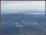
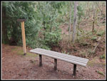
We reached the ridge and headed up towards the upper towers. We found a spot out of the light wind for a food and water break. It was 10:57 am. We took 2:25 to hike up 4.2 miles. It was a slow pace but we were in no hurry. Though Mt. Rainier was still in the clouds, views in other directions were excellent. After our early lunch, we headed around the summit on the Preston-Poo Top Trails over to the Hikers Hut. Time for another short break and photos. Then it was time for the steep drop and shorter climb up to Tiger 2. The views were great on Tiger 2. I sat down on the summit and took off my gloves to take off a shoe and remove a rock. We headed down and then up to Tiger 3, our final summit of the day. Just a few photos and we were on our way down. A little more than half a mile down I reached for my gloves and did not find them. They were up on top of Tiger 2. Oh well... At about this point we reached the 7 miles mark. That was the point where I reached 1000 miles for the year.
Gary suggested one more detour. We took the Talus Rocks Trail over to the rocks. We passed the waterfall. It was not roaring but had a steady stream coming down. Up at the rocks we started our last descent. On the way down the Nook Trail we kept meeting hikers coming up. I did not think the Nook Trail was very popular but it was this day. At the bottom, we were only a few minutes from the parking lot. Now we just had to take the Connector Trail back to the gate and walk the length of the road back to the car near the interchange. We reached the car at 1:12 pm. It only took a few minutes to drive back to my car at the Preston Trailhead.
The 10 miles and 3000' of gain helped on my rush to reach goals by the end of the year. This day I reached 1000 miles for only the third time. It started out wet with high winds forecast up high. The morning light rain ended and the high winds never happened. It was cold up high but not too bad. I was disappointed to lose my gloves but my New Year's Eve trip report has more on that situation. Nine hikes in eighteen days at the end of the year is challenging. I took off the whole day for this hike and half days for two more. I seldom have years with either 1000 miles or 250,000' feet of gain and I wanted to really run up the numbers at the end. This has been a really good year on the trail.
Click on thumbnails to get
larger pictures.
Trips - 2023
Home
We met at High Point East at about 8:20 am. The drive to the Preston Trailhead was only a few minutes. As expected there were no cars at that trailhead. We were on our way at 8:32 am. Umbrellas were out almost immediately. The route quickly reaches the powerline corridor. It is filled with big and small rocks to provide for equipment to drive it in wet winter conditions without getting stuck in the mud. These rocks are not much fun to walk on. That is the main reason we do not do this trail very often. This day it did not seem so bad. Lots of fallen leaves seemed to cushion the sharp rocks a little. Soon enough, we turned off the road into the forest on soft dirt tread. The rain was less noticeable in the forest. Since I was looking to maximize mileage, we took the main trail rather than the shortcut. At the next junction, Gary suggested taking the longer Bootleg Trail. I was a little concerned as this trail crosses several creeks. None of them on bridges. They all turned out to be rock hops with dry feet. I had on my low tops as less weight won out over waterproof.
At the next junction we went past the old Christmas tree. It still has zero ornaments. We merged back onto the Bootleg Trail where the seriously narrow gate has been in place for decades. It is now gone. Totally gone. The trail now climbs up towards Tiger 1. The rain had stopped and conditions were now pretty good. Rather than take the path up to the lower towers, we stayed on the trail. The top of the old Bootleg Trail near the Preston Trail junction used to be brushy with a big step. Now it is flatter and open. It seems that when the new upper Preston Trail was built through the recent clearcut, they fixed this nearby trail section. Gary and I had not yet hiked the new section up to the ridge top. Gary did it cross country before the trail was finished. A lot of work was done to cut out the many logs and stumps that littered the hillside recently. As we neared the top we were listening for the sound of those 25 mph wind gusts. We heard nothing. The wind was very light. We also saw a few shadows. The total overcast now had a few breaks in it.
We reached the ridge and headed up towards the upper towers. We found a spot out of the light wind for a food and water break. It was 10:57 am. We took 2:25 to hike up 4.2 miles. It was a slow pace but we were in no hurry. Though Mt. Rainier was still in the clouds, views in other directions were excellent. After our early lunch, we headed around the summit on the Preston-Poo Top Trails over to the Hikers Hut. Time for another short break and photos. Then it was time for the steep drop and shorter climb up to Tiger 2. The views were great on Tiger 2. I sat down on the summit and took off my gloves to take off a shoe and remove a rock. We headed down and then up to Tiger 3, our final summit of the day. Just a few photos and we were on our way down. A little more than half a mile down I reached for my gloves and did not find them. They were up on top of Tiger 2. Oh well... At about this point we reached the 7 miles mark. That was the point where I reached 1000 miles for the year.
Gary suggested one more detour. We took the Talus Rocks Trail over to the rocks. We passed the waterfall. It was not roaring but had a steady stream coming down. Up at the rocks we started our last descent. On the way down the Nook Trail we kept meeting hikers coming up. I did not think the Nook Trail was very popular but it was this day. At the bottom, we were only a few minutes from the parking lot. Now we just had to take the Connector Trail back to the gate and walk the length of the road back to the car near the interchange. We reached the car at 1:12 pm. It only took a few minutes to drive back to my car at the Preston Trailhead.
The 10 miles and 3000' of gain helped on my rush to reach goals by the end of the year. This day I reached 1000 miles for only the third time. It started out wet with high winds forecast up high. The morning light rain ended and the high winds never happened. It was cold up high but not too bad. I was disappointed to lose my gloves but my New Year's Eve trip report has more on that situation. Nine hikes in eighteen days at the end of the year is challenging. I took off the whole day for this hike and half days for two more. I seldom have years with either 1000 miles or 250,000' feet of gain and I wanted to really run up the numbers at the end. This has been a really good year on the trail.
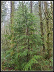 Tiger Christmas Tree |
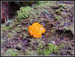 Witches Butter |
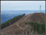
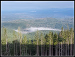 Tiger 1 View North |
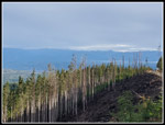 View East |
 Camp Robber Jay |
 Tiger 3 From Tiger 2 |
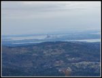 Seattle & Cougar Mt. |
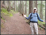
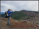 Gary On Tiger 2 |
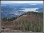 Tiger 3 & Lk Sammamish |
 View West |
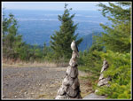
 1000 Miles |
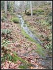 Waterfall |
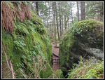 Mossy Talus Rocks |
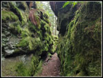 Trail Through Gap |
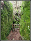 Last Talus Rocks |
 Pipsee's View |
Trips - 2023
Home