04-15-23
The
day before I did an 8 mile hike
with 2400' of gain on Tiger 3 & 2. My sore knee held up pretty
well. I would normally taken a day off and hiked on Sunday. Saturday
was supposed to be damp and Sunday soaking wet. I woke up Saturday and
the rain was now going to hold off until the afternoon. I decided to
test my knee on a back to back hike on dry trail rather than hike
Sunday on a wetter and muddier trail. I still had not had a good spring
wildflower hike. I also did not want a lot of elevation gain after
2400' of descent the day before. I made a quick decision to stay low
and close by and do a Tiger hike I had not done in a year. My last
minute planning had me out the door a bit late at 7:43 am. I arrived at
the Tiger Mountain Trail (TMT) south trailhead at 8:28 am. There were
already at least half a dozen cars there. Not crowded but this trail
seldom is in the morning. I grabbed my pack and was on my way at 8:32
am.
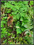
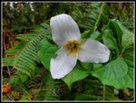
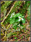
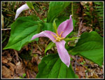
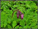
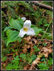
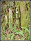
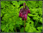
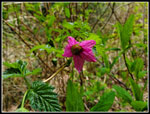
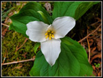
I made it a minute or two up the trail when I started seeing blooming trillium. I have seen a few the past couple weeks but this was so much better. They showed up in a number of places in the first mile of the trail. My progress was very slow as I kept taking photos. Next, I saw a couple of blooming bleeding hearts. These were very dark red. I thought that might be the end of them. Well, not quite. I came upon some bright pink trillium. They looked to be near finished as they often look in June. They are not supposed to look like that in mid April. A little farther along on the left side I came to a big bunch of bleeding hearts. These made up the majority of them I saw this day. Most very dark red with a few lighter ones like most appear as they begin to age.
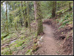
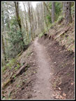
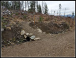
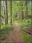
There were few short muddy sections of trail. As I neared the first junction, the trail has been recently rebuilt. At one mile in, I reached the junction. To the right is the horse trail. I came back that way. I went left on the hiker trail. The beginning of both trails show recent trail work. The left route crosses a very steep slope on what was a narrow boot path. Now it is smooth as the tread had been completely reworked. It is still relatively narrow but is much easier to hike. At 1.4 miles I reached the old road where the hiker and horse trails meet. Right on the road is the TMT. I went left and then right and steeply uphill. This was the steepest section of the day. Though this was my second hike in less than 24 hours, my knee felt pretty good.
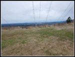
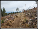
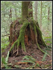
The road/trail flattens at the big powerline corridor. These pylons are huge. The sky was white and I could see out to the lowlands but the peaks were in the clouds. The road used to end and a trail continued forward. Since a clearcut a decade or so ago the old trail is now a wide logging road. It climbs up the clearcut. I saw coltsfoot in bloom along here. The trail leaved the road and turns right heading for South Tiger Mountain. I chose to continue on the road for another .20 miles gaining 100'. There is a very good look at Mt. Rainier from up this road. This day I could see the bottom but most of Rainier was lost in clouds. I descended to the trail and left the road. The trail enters forest and soon the bare slopes of South Tiger come into view. The trails switchbacks higher and leaves forest. A road is crossed and the trail turns left. It contours under the southern summit of South Tiger Mountain. There is a big stump with rocks for eyes and a cut mouth where the old summit spur trail headed up in deep forest. Now it is all clearcut.
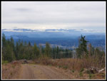
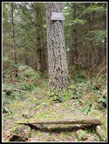
Since the clearcut, I have been along this trail a couple of times. Each time, I followed the old trail until it is lost under down logs. I then worked through the logs to the real summit. The summit has piles of big down trees. With my sore knee, I chose to just keep hiking on the main trail. There were more signs of recent trail rebuilding along here. The trail drops to the road I had crossed earlier. The trail crossed the road. I turned right on the road. I shortly reached another road junction. This time I turned right on a spur that goes up between the two summits of South Tiger Mountain. I passed a hiker coming down the road. At the top I took the short trail to the summit of the northern South Tiger peak. It is now completely enclosed by trees. There is still a bench with a fire pit but that is all. I looked back at old trip reports and 2012 I could see East Tiger and Mt. Si over the small trees. The clearcut must have been 3 or 4 years before that. I had a short food break and headed down.
I followed the road back to the road junction. The road continues and meets up with the trail below. I decided to turn left and return to the point where I got onto the road earlier. I took a right turn on the South Tiger Mountain Traverse Trail. This is the trail I had been hiking on earlier. It descends into a swampy area before reaching the parallel road I recently left. The trail used to be a bit muddy at the low spot. With the trail work I had seen earlier, I wondered if the mud had been dealt with. Boy has it ever! from the road junction where I started to the road at the other end the entire section has been heavily graveled. In places it is 4-6 inches deep. In places it has 4x4 lumber holding in the deep gravel. It is dry but nothing like a wilderness trail now.
At the end of the trail I reached a road. I went 15' left to pick up the old horse trail up to the Carole Hapke picnic spot. It has a bench and had/has a place to tie up horses. The start of the trail is quite overgrown and hard to see. Most of it is narrow but easy to hike. The top is now in dense forest with brush. I recall when it was a clearcut viewpoint. This detour added .25 miles with 100' of gain. I dropped back to the road and turned left. In less than a minute I met the road that goes up South Tiger Mountain. The road drops to where the TMT comes around the backside of South Tiger. At that point, I turned left and headed over to the main road from Tiger Summit trailheads. This added half a mile round trip with minimal gain. When I returned to the TMT junction I turned left onto it. The TMT here is an old road that has narrowed to trail in most spots.
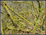
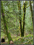
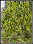
The TMT very gentle loses a little elevation. I found skunk cabbage in bloom along here. Holder Creek runs well below to the left. This section has some very mossy trees and logs. I passed by a metal 3 mile marker. Just beyond is a wooden square that is illegible but probably is also a 3 mile marker. I did pass several groups going the other way. This route ends at a gravel road. The big powerline corridor I passed early in the day is to the left. The gravel spur goes over to beneath the big power pylons. The power buzzing was quite audible. There did not used to be a sign at the junction with the main road under the powerlines. For the past half dozen years there is one showing the two directions of the TMT. I followed the road to another sign showing the TMT turning to the left. The trail continues back to th 1.4 mile mark where the horse and hikers trails come back together. There is one creek crossing that is easy most of the year but is wide now. It is not deep but I wanted to keep dry feet and went upstream a bit to a point where I could jump across.
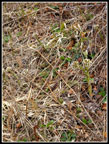
At the 1.4 mile junction I took the horse trail back. There were trillium blooming at the start. This trail has seen major tread work. Sections have been dug out and are much smoother now.That make it easier with a sore knee. Speaking of which, it was not hurting much at all. Back to back hikes did not set back my recovery. I reached the hiker trail junction and just had one mile to go. This was the most wildflower filled part of the hike. I spent a lot of time taking even more photos. A short way down I saw a yellow violet. That is a harbinger of spring and it took until mid April to see my first one this year. There were two of them in bloom. That was it. I finally made it back to my car at 12:32 pm. There were many more cars though empty spots still existed.
I at least partially resurrected a really awful hiking month. In two days I went from 8 miles with 1200' of gain to 24 miles with 5300' of gain. It is still a bad month but there is hope I can get to at least 50 miles and 10,000' of gain. My knee was only a little sore and that is great news. I made it almost home before the expected rain set in. This has been a late wildflower season but this was by far the best such hike this year.
Click on thumbnails to get
larger pictures.
Trips - 2023
Home
I made it a minute or two up the trail when I started seeing blooming trillium. I have seen a few the past couple weeks but this was so much better. They showed up in a number of places in the first mile of the trail. My progress was very slow as I kept taking photos. Next, I saw a couple of blooming bleeding hearts. These were very dark red. I thought that might be the end of them. Well, not quite. I came upon some bright pink trillium. They looked to be near finished as they often look in June. They are not supposed to look like that in mid April. A little farther along on the left side I came to a big bunch of bleeding hearts. These made up the majority of them I saw this day. Most very dark red with a few lighter ones like most appear as they begin to age.
There were few short muddy sections of trail. As I neared the first junction, the trail has been recently rebuilt. At one mile in, I reached the junction. To the right is the horse trail. I came back that way. I went left on the hiker trail. The beginning of both trails show recent trail work. The left route crosses a very steep slope on what was a narrow boot path. Now it is smooth as the tread had been completely reworked. It is still relatively narrow but is much easier to hike. At 1.4 miles I reached the old road where the hiker and horse trails meet. Right on the road is the TMT. I went left and then right and steeply uphill. This was the steepest section of the day. Though this was my second hike in less than 24 hours, my knee felt pretty good.
The road/trail flattens at the big powerline corridor. These pylons are huge. The sky was white and I could see out to the lowlands but the peaks were in the clouds. The road used to end and a trail continued forward. Since a clearcut a decade or so ago the old trail is now a wide logging road. It climbs up the clearcut. I saw coltsfoot in bloom along here. The trail leaved the road and turns right heading for South Tiger Mountain. I chose to continue on the road for another .20 miles gaining 100'. There is a very good look at Mt. Rainier from up this road. This day I could see the bottom but most of Rainier was lost in clouds. I descended to the trail and left the road. The trail enters forest and soon the bare slopes of South Tiger come into view. The trails switchbacks higher and leaves forest. A road is crossed and the trail turns left. It contours under the southern summit of South Tiger Mountain. There is a big stump with rocks for eyes and a cut mouth where the old summit spur trail headed up in deep forest. Now it is all clearcut.
Since the clearcut, I have been along this trail a couple of times. Each time, I followed the old trail until it is lost under down logs. I then worked through the logs to the real summit. The summit has piles of big down trees. With my sore knee, I chose to just keep hiking on the main trail. There were more signs of recent trail rebuilding along here. The trail drops to the road I had crossed earlier. The trail crossed the road. I turned right on the road. I shortly reached another road junction. This time I turned right on a spur that goes up between the two summits of South Tiger Mountain. I passed a hiker coming down the road. At the top I took the short trail to the summit of the northern South Tiger peak. It is now completely enclosed by trees. There is still a bench with a fire pit but that is all. I looked back at old trip reports and 2012 I could see East Tiger and Mt. Si over the small trees. The clearcut must have been 3 or 4 years before that. I had a short food break and headed down.
I followed the road back to the road junction. The road continues and meets up with the trail below. I decided to turn left and return to the point where I got onto the road earlier. I took a right turn on the South Tiger Mountain Traverse Trail. This is the trail I had been hiking on earlier. It descends into a swampy area before reaching the parallel road I recently left. The trail used to be a bit muddy at the low spot. With the trail work I had seen earlier, I wondered if the mud had been dealt with. Boy has it ever! from the road junction where I started to the road at the other end the entire section has been heavily graveled. In places it is 4-6 inches deep. In places it has 4x4 lumber holding in the deep gravel. It is dry but nothing like a wilderness trail now.
At the end of the trail I reached a road. I went 15' left to pick up the old horse trail up to the Carole Hapke picnic spot. It has a bench and had/has a place to tie up horses. The start of the trail is quite overgrown and hard to see. Most of it is narrow but easy to hike. The top is now in dense forest with brush. I recall when it was a clearcut viewpoint. This detour added .25 miles with 100' of gain. I dropped back to the road and turned left. In less than a minute I met the road that goes up South Tiger Mountain. The road drops to where the TMT comes around the backside of South Tiger. At that point, I turned left and headed over to the main road from Tiger Summit trailheads. This added half a mile round trip with minimal gain. When I returned to the TMT junction I turned left onto it. The TMT here is an old road that has narrowed to trail in most spots.
The TMT very gentle loses a little elevation. I found skunk cabbage in bloom along here. Holder Creek runs well below to the left. This section has some very mossy trees and logs. I passed by a metal 3 mile marker. Just beyond is a wooden square that is illegible but probably is also a 3 mile marker. I did pass several groups going the other way. This route ends at a gravel road. The big powerline corridor I passed early in the day is to the left. The gravel spur goes over to beneath the big power pylons. The power buzzing was quite audible. There did not used to be a sign at the junction with the main road under the powerlines. For the past half dozen years there is one showing the two directions of the TMT. I followed the road to another sign showing the TMT turning to the left. The trail continues back to th 1.4 mile mark where the horse and hikers trails come back together. There is one creek crossing that is easy most of the year but is wide now. It is not deep but I wanted to keep dry feet and went upstream a bit to a point where I could jump across.
At the 1.4 mile junction I took the horse trail back. There were trillium blooming at the start. This trail has seen major tread work. Sections have been dug out and are much smoother now.That make it easier with a sore knee. Speaking of which, it was not hurting much at all. Back to back hikes did not set back my recovery. I reached the hiker trail junction and just had one mile to go. This was the most wildflower filled part of the hike. I spent a lot of time taking even more photos. A short way down I saw a yellow violet. That is a harbinger of spring and it took until mid April to see my first one this year. There were two of them in bloom. That was it. I finally made it back to my car at 12:32 pm. There were many more cars though empty spots still existed.
I at least partially resurrected a really awful hiking month. In two days I went from 8 miles with 1200' of gain to 24 miles with 5300' of gain. It is still a bad month but there is hope I can get to at least 50 miles and 10,000' of gain. My knee was only a little sore and that is great news. I made it almost home before the expected rain set in. This has been a late wildflower season but this was by far the best such hike this year.
 First Trillium |
 Fully Blooming Trillium |
 Multiple Blooms |
 Already Finished? |
 Blooming Bleeding Hearts |
 Mossy Branches |
 New Trail Work |
 Another Trillium |
 Trail Work |
 Powerline Corridor |
 Rainier View? |
 Coltsfoot |
 Trail Crosses Road |
 South Tiger Traverse |
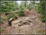 South Tiger Summit |
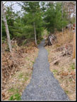 Gravel Trail |
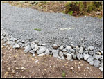 Lots Of Gravel |
 Carole Hapke Picnic Area |
 Tiger Mountain Trail |
 Skunk Cabbage |
 3 Mile Marker |
 Very Green Moss |
 Grown From Stump |
 Road To Trail |
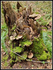 Fungi Galore |
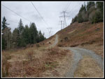 Powerlines Again |
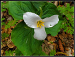 Back To Trillium |
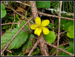 Yellow Violet |
 More Bleeding Hearts |
 Salmonberry Flower |
 A Last Trillium |
 Extremely Mossy Tree |
Trips - 2023
Home