04-14-23
The
month was slipping away. My sore knee was not healing very fast. I went
out the week before on Good Friday and had to miss another mid-week
hike. Friday was sunny and the weekend looked to be rainy. At the last
minute I decided to head out for a hike mid day on Friday. For the
first nearly half of the month I had hiked 8 miles with 1200' of
elevation gain. My consecutive month streak of at least 10,00' of gain
was 211 months long. That is 17 years and 7 months. I was not going to
let it end without a fight. The knee was very painful on Monday and
improved each day. It was still sore on Thursday but felt much better
Friday morning. I needed elevation gain but not a long hike where I
would be far from my car if the pain returned. I settled on a trip I
seldom do because of the crowds. I went up Tiger 3 via the main trail
from the High Point parking lot. The lot was about 2/3 full when I
arrived at 2:10 pm. I was on my way at 2:15 pm.
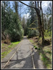
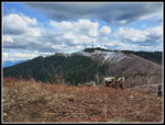
Over the years I have done the trail up Tiger 3 over 100 times. The route has changed at least four times, all of it on the upper half. Getting up Tiger 3 would gain 2000' in only 2.75 miles. If I felt good I could go further. I had on light hiking shoes and my summer weight backpack for the first time in about 5 months. Light is good. In the first half mile I saw quite a few hikers coming down. I caught up with a few and was passed by a few runners. Overall, it was not as crowded as I expected. Going uphill was not a problem for my knee. I set a steady pace but slower than I would usually go. I reached the summit of Tiger 3 at 3:23 pm. It took me 1:08 to hike up 2.75 miles with 2000' of gain.
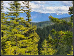
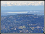
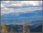
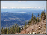
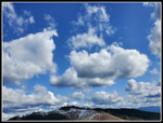
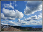
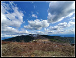
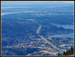
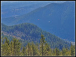
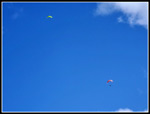
The sky was a mix of bright blue and layers of clouds. The clouds were not very high. I could see the tops and bottoms of some. Mt. Rainier was lost in clouds to the south. Mt. Baker was not seen to the north. The Olympics were in clouds. The Cascade front peaks were visible. Seattle was in the clear. Views were actually pretty good. Tiger 3 had no snow. Tiger 2 had s few small spots on the north side in shade with a little snow. I took a short break and considered my options. My knee felt pretty good. Uphill was not painful. I already had 2000' of downhill to go. Should I continue on to Tiger 2? After a little internal debate I decided to continue on to Tiger 2. Dropping off Tiger 3 was the hardest part. The steep route off the top is loose and not what I wanted to descend. After than, the new trail is gently graded down to the bottom. I was watching all the parasailors over near Poo Poo Point. The mid 50s "heat" provided some thermals to ride.
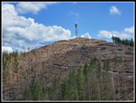
It is only a little over half a mile to the top of Tiger 2. I arrived at 3:46 pm. It was still early and I was not in a hurry. I did not want to return to early and end up in rush hour traffic. The detour to Tiger 2 made that less likely. The north side of Tiger 1 still had snowy ground. The road from Tiger 2 was bare all the way to the summit. I a couple runners go by and two mountain bikers arrived. The trails are this side of Tiger are not for bikers so they had to have come via road from Tiger Summit over on Highway 18. Bikes are very rarely seen on Tiger 2. I took a 15 minute break before starting back. I had short sleeves on the way up. With a cool breeze on the summit I had my windshirt on. The descent down the road is easy and I made it back to Tiger 3 without any knee pain. So far so good.
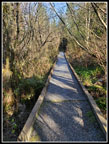
I took another break atop Tiger 3. There were now a lot of parasailors in site. Some were far from Poo Poo Point. I took a lot more clouds photos. They were the best part of the trip. Great contrast between bright blue sky and bright white to light black clouds. Just before I headed down I looked right overhead and there were two parasailors up there. It brought back memories of the old days when big gliders flew right over Tiger 3 before landing at the airport in Issaquah. I headed down at 4:30 pm. My pace was slower than normal but steady. About half way down the front of my knee complained a little. Some pain but not as much as a week before. I made it back down to the parking lot at 5:36 pm. I still felt pretty good so I decided to head over to the Swamp Trail. I hiked it in the fall and at a junction I took a right for the first time. It led to a series of raised boardwalks through a mostly dry swamp. I figured after the rainy season it should be a big wet swamp. Perfect conditions for skunk cabbage. I headed there to find out.
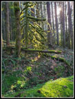
The swamp was very wet. A short way down the boardwalk I found blooming skunk cabbage. Not a lot of them but they were bright yellow and near their peak. I continued to the powerline corridor and turned around. I was back at my car at 6:11 pm. The hike up Tiger 3 was 5.5 miles with 2000' of gain. Adding a trip to Tiger 2 and another on the Swamp Trail brought my day up to 8 miles with 2400' of gain. This was only by second hike in 15 days. April still was literally miles behind other months. Still, I doubled my miles and tripled my elevation gain. Now I was one day short of the middle of the month and had 16 miles hiked with 3600' of gain. At least it was an improvement.
The best part of the day is that I had only minor knee pain. I still have a ways to go but it was much better than after my hike one week earlier. Traffic was not bad on the way home. I managed to get in a mostly sunny hike before another dark and dreary weekend.
Click on thumbnails to get
larger pictures.
Trips - 2023
Home
Over the years I have done the trail up Tiger 3 over 100 times. The route has changed at least four times, all of it on the upper half. Getting up Tiger 3 would gain 2000' in only 2.75 miles. If I felt good I could go further. I had on light hiking shoes and my summer weight backpack for the first time in about 5 months. Light is good. In the first half mile I saw quite a few hikers coming down. I caught up with a few and was passed by a few runners. Overall, it was not as crowded as I expected. Going uphill was not a problem for my knee. I set a steady pace but slower than I would usually go. I reached the summit of Tiger 3 at 3:23 pm. It took me 1:08 to hike up 2.75 miles with 2000' of gain.
The sky was a mix of bright blue and layers of clouds. The clouds were not very high. I could see the tops and bottoms of some. Mt. Rainier was lost in clouds to the south. Mt. Baker was not seen to the north. The Olympics were in clouds. The Cascade front peaks were visible. Seattle was in the clear. Views were actually pretty good. Tiger 3 had no snow. Tiger 2 had s few small spots on the north side in shade with a little snow. I took a short break and considered my options. My knee felt pretty good. Uphill was not painful. I already had 2000' of downhill to go. Should I continue on to Tiger 2? After a little internal debate I decided to continue on to Tiger 2. Dropping off Tiger 3 was the hardest part. The steep route off the top is loose and not what I wanted to descend. After than, the new trail is gently graded down to the bottom. I was watching all the parasailors over near Poo Poo Point. The mid 50s "heat" provided some thermals to ride.
It is only a little over half a mile to the top of Tiger 2. I arrived at 3:46 pm. It was still early and I was not in a hurry. I did not want to return to early and end up in rush hour traffic. The detour to Tiger 2 made that less likely. The north side of Tiger 1 still had snowy ground. The road from Tiger 2 was bare all the way to the summit. I a couple runners go by and two mountain bikers arrived. The trails are this side of Tiger are not for bikers so they had to have come via road from Tiger Summit over on Highway 18. Bikes are very rarely seen on Tiger 2. I took a 15 minute break before starting back. I had short sleeves on the way up. With a cool breeze on the summit I had my windshirt on. The descent down the road is easy and I made it back to Tiger 3 without any knee pain. So far so good.
I took another break atop Tiger 3. There were now a lot of parasailors in site. Some were far from Poo Poo Point. I took a lot more clouds photos. They were the best part of the trip. Great contrast between bright blue sky and bright white to light black clouds. Just before I headed down I looked right overhead and there were two parasailors up there. It brought back memories of the old days when big gliders flew right over Tiger 3 before landing at the airport in Issaquah. I headed down at 4:30 pm. My pace was slower than normal but steady. About half way down the front of my knee complained a little. Some pain but not as much as a week before. I made it back down to the parking lot at 5:36 pm. I still felt pretty good so I decided to head over to the Swamp Trail. I hiked it in the fall and at a junction I took a right for the first time. It led to a series of raised boardwalks through a mostly dry swamp. I figured after the rainy season it should be a big wet swamp. Perfect conditions for skunk cabbage. I headed there to find out.
The swamp was very wet. A short way down the boardwalk I found blooming skunk cabbage. Not a lot of them but they were bright yellow and near their peak. I continued to the powerline corridor and turned around. I was back at my car at 6:11 pm. The hike up Tiger 3 was 5.5 miles with 2000' of gain. Adding a trip to Tiger 2 and another on the Swamp Trail brought my day up to 8 miles with 2400' of gain. This was only by second hike in 15 days. April still was literally miles behind other months. Still, I doubled my miles and tripled my elevation gain. Now I was one day short of the middle of the month and had 16 miles hiked with 3600' of gain. At least it was an improvement.
The best part of the day is that I had only minor knee pain. I still have a ways to go but it was much better than after my hike one week earlier. Traffic was not bad on the way home. I managed to get in a mostly sunny hike before another dark and dreary weekend.
 Starting Out |
 Coltsfoot |
 First Views |
 Parasailor |
 Downtown Seattle |
 Fuller Mountain |
 Tiger 2 |
 Seattle & Bellevue |
 Snow On Tiger 1 |
 Great Cloud Show |
 Clouds To The Soth |
 Wide Angle Clouds |
 Issaquah Is Below |
 More Parasailors |
 Parasailors Overhead |
 Sunlit Green |
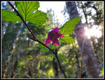 Salmonberry Flower |
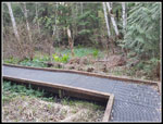 Swamp Trail Boardwalk |
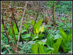 Skunk Cabbage |
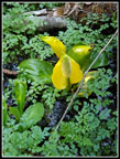 Close Up |
 Heading Back |
Trips - 2023
Home