08-12-23
This
would be the start of hot weather. Around 80 today and then up to the
low 90s over the next half a dozen days. I wanted to get in a long hike
with plenty of shade. I kicked around ideas and came up with a loop up
to Wallace and Jay Lakes. The drive is fairly short and the gentle
grade makes for fast hiking. I needed to get in miles and head for home
before the heat of the day. I was on the road by 6:45 am. I headed up
Highway 2 to Gold Bar and then to the trailhead. I arrived at 7:48 am.
The lot was about 60% full. It as 57 degrees and I started with a long
sleeve shirt and shorts. The sky was clear as I headed out. I took the
old Railroad Grade Trail passing two folks coming down. The second one
was just before the 1.5 mile junction. He stopped to tell me he had
just seen a cougar. It went left and above the road/grade/trail. I
planned to head off left at the junction with the trail up to
the DNR logging road. That is the direction the cat seemed to be
heading. Earlier this year I saw just the second bobcat in 41 years of
hiking. I still had not seen a cougar. I have seen cougar tracks in the
snow following my tracks on my way out several times. I just had/have
never seen one in person. I was fine with keeping that streak going. I
turned onto my route an picked up a couple rocks. I also raised my
voice to alert said cat that I was there. I was pleased to reach the
DNR Road without seeing the cougar.
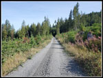
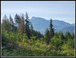
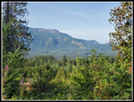
At that point I stopped to switch into a short sleeve shirt. It was warming up quickly. My plan was to hike the open road in the morning sun and come down the forested Greg Ball Trail in the afternoon. Sunshine while it was cooler and shade for the warmer afternoon. My last trip up this route, though in reverse, was last November. That day I started with the temperature in the high 30s. This day would be about forty degrees warmer. Along the road I began to notice the blackberries. In the sunshine there were a lot of ripe berries. I was out for a fast hike but I did stop for berries more than a few times. In shady areas the berries were often still green. I even saw a few flowering. Later on I added some ripe thimbleberries to my diet. I reached the road at 2.4 miles. I had another 3.5 miles to reached the mileage sign just after the top of the Greg Ball Trail. At 2.40 miles my gps read 2.42 miles. That is very accurate. I had some views across the valley to the other ridge and up valley to Mt. Persis and Mt. Index. The views were good though a bit hazy. I passed the Greg Ball Trail junction and a few minutes later left the road for the old road/trail to Wallace Lake. For once, I will not complain about the thick layer of sharp rocks on the start of this route. It looked like they have dumped even more on recently.
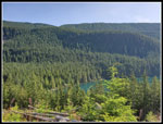
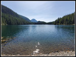
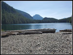
I reached Wallace Lake at 10:00 am. That was 6.6 uphill miles in 2:08 total time. My moving time was 2:00 exactly. I was very pleased with 3.3 mph uphill. Uphill but never steep. After a few photos of the lake from the outlet bridge, I headed around the lake. Part way I headed out into the clearcut. I wanted to get near 2000' of gain and that required a couple side trips. In this one I went to the point on the ridge top looking down on Wallace Lake. At least a little of the lake. I went out to two more viewpoints of the valley. I then headed back to the lake. I measured it at 1.3 mile with about 220' of gain. I continued to the short trail down to a bench above the short. I had a very nice view of the lake last November from there. This day I had branches and leaves blocking most of the view. I quickly headed on to the inlet creek. As expected, the creek was dry. I walked down the creek bed ducking under more branches. Near the lake I climbed up a mound of gravel to Pebble Beach. There were several big logs on the gravel mound. I have been hiking to here since 1989. In 34 years I have not seen Pebble Beach look like this. Something pushed the gravel up into a small mound and deposited big logs atop it. I am exaggerating the size a bit but it could be a real problem in the rainy seasons. The creek will not flow into the lake. It will push to the sides and may create a lake back where the trail crosses the creek. That may make it dangerous to cross to continue to Jay Lake. Time will tell.
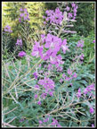
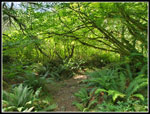
I had a short food and water break and took more photos of the beach. I then headed back to the trail. It is a pleasant and mostly flat hike one mile on to Jay Lake. Jay Lake is so brushy that I have seldom seen much of the lake. Still, it is a pleasant walk. I reached Jay Lake at 11:32 am. I had traveled 9.6 miles so far. The temperature was rising but my route was mostly in cool shade. I headed down to the shore and found eight foot tall brush with a narrow route through it. In November I could not go more than a few feet before reaching the much higher lake. Now, the lake was quite low. I was able to get through the brush and still find some dry ground. I had the best view of the lake ever. I took a few panorama shots showing the whole lake. This trip is an off season destination usually. I seldom find the lake to low. After photos, I headed back. Along the way I stopped for some super close up shots of foam flowers and spring (summer?) beauties. They are two very small flowers. When I reached Wallace Lake I decided not to head back to Pebble Beach. I had not passed anyone since the cougar guy at 1.5 miles. I now had traveled. 10.6 miles. That is a lot of solitude in one of the most popular hiking state parks.
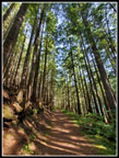
I was still well short of 2000' of gain so I headed out into the clearcut one more time. This time I only went up to the lower viewpoint. That added .70 miles and 80'of gain. For the second time in the past couple years I took th wrong turn coming back. There is a four way junction. Two directions go around the lake, one goes into the clearcut, and the last one is the old road where campers could drive to the lake before my time. I was thinking about something and took the downhill route. It did not take long to discover my error. The park folks have even places a sign warning about this long wrong turn. I then continued around the lake to the outlet and headed on to the route to the DNR road. I finally saw some hikers on this section. At the top of the Greg Ball Trail I turned left onto the trail. My route down the Greg Ball Trail and then the Railroad Grade would be 4.2 miles My route up the road was 5.9 miles. The trail is much more shaded and 1.7 miles shorter than the road route. The road does provide a lot of solitude and more mileage. I did not expect solitude the rest of the way down. I did not get it.
This trail being busy is not a thing like the Wallace Falls Trail. I saw groups every ten to 15 minutes on my route. The Falls Trail is much more crowded. After the fast ascent my pace slowed around the lakes. I was down from 3.3 mph to 2.8 for the trip. I picked it up a little on the way down. This was my first trip with a pair of lightweight hiking shoes and they fit very well. Just the number of miles had the bottoms of my feet getting a little sore. From the bottom of the GBT the Woody Trail is the shortest way back. I was still looking for miles so I took the longer Railroad Grade. When I popped out of the woods for the last quarter mile it was feeling much warmer. My car thermometer registered 80 degrees when I left. I was not at all surprised to find the parking lot full at 2:12 pm.
This trip was just what I was hoping for. An early start and little used route allowed me to see very few people before I headed down from Wallace Lake. Many fewer than I expected. The morning was sunny but not hot and the forest kept me mostly cool. The last quarter mile was very hot. For the day I hiked 16.2 miles with 1900' of elevation gain. That almost doubled my monthly mileage. I probably won't get out again until next weekend but 16 mile was not too bad for this week. By next weekend cooler weather should be back. The only problem was the drive home. It wasn't even Gold Bar to Sultan that was the problem. Monroe was the worst. I-5 had a collision. My 62 minute morning drive grew to 105 minute coming home. That was not a bad price to pay for a really nice longer hike.
Click on thumbnails to get
larger pictures.
Trips - 2023
Home
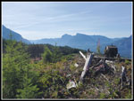
At that point I stopped to switch into a short sleeve shirt. It was warming up quickly. My plan was to hike the open road in the morning sun and come down the forested Greg Ball Trail in the afternoon. Sunshine while it was cooler and shade for the warmer afternoon. My last trip up this route, though in reverse, was last November. That day I started with the temperature in the high 30s. This day would be about forty degrees warmer. Along the road I began to notice the blackberries. In the sunshine there were a lot of ripe berries. I was out for a fast hike but I did stop for berries more than a few times. In shady areas the berries were often still green. I even saw a few flowering. Later on I added some ripe thimbleberries to my diet. I reached the road at 2.4 miles. I had another 3.5 miles to reached the mileage sign just after the top of the Greg Ball Trail. At 2.40 miles my gps read 2.42 miles. That is very accurate. I had some views across the valley to the other ridge and up valley to Mt. Persis and Mt. Index. The views were good though a bit hazy. I passed the Greg Ball Trail junction and a few minutes later left the road for the old road/trail to Wallace Lake. For once, I will not complain about the thick layer of sharp rocks on the start of this route. It looked like they have dumped even more on recently.
I reached Wallace Lake at 10:00 am. That was 6.6 uphill miles in 2:08 total time. My moving time was 2:00 exactly. I was very pleased with 3.3 mph uphill. Uphill but never steep. After a few photos of the lake from the outlet bridge, I headed around the lake. Part way I headed out into the clearcut. I wanted to get near 2000' of gain and that required a couple side trips. In this one I went to the point on the ridge top looking down on Wallace Lake. At least a little of the lake. I went out to two more viewpoints of the valley. I then headed back to the lake. I measured it at 1.3 mile with about 220' of gain. I continued to the short trail down to a bench above the short. I had a very nice view of the lake last November from there. This day I had branches and leaves blocking most of the view. I quickly headed on to the inlet creek. As expected, the creek was dry. I walked down the creek bed ducking under more branches. Near the lake I climbed up a mound of gravel to Pebble Beach. There were several big logs on the gravel mound. I have been hiking to here since 1989. In 34 years I have not seen Pebble Beach look like this. Something pushed the gravel up into a small mound and deposited big logs atop it. I am exaggerating the size a bit but it could be a real problem in the rainy seasons. The creek will not flow into the lake. It will push to the sides and may create a lake back where the trail crosses the creek. That may make it dangerous to cross to continue to Jay Lake. Time will tell.
I had a short food and water break and took more photos of the beach. I then headed back to the trail. It is a pleasant and mostly flat hike one mile on to Jay Lake. Jay Lake is so brushy that I have seldom seen much of the lake. Still, it is a pleasant walk. I reached Jay Lake at 11:32 am. I had traveled 9.6 miles so far. The temperature was rising but my route was mostly in cool shade. I headed down to the shore and found eight foot tall brush with a narrow route through it. In November I could not go more than a few feet before reaching the much higher lake. Now, the lake was quite low. I was able to get through the brush and still find some dry ground. I had the best view of the lake ever. I took a few panorama shots showing the whole lake. This trip is an off season destination usually. I seldom find the lake to low. After photos, I headed back. Along the way I stopped for some super close up shots of foam flowers and spring (summer?) beauties. They are two very small flowers. When I reached Wallace Lake I decided not to head back to Pebble Beach. I had not passed anyone since the cougar guy at 1.5 miles. I now had traveled. 10.6 miles. That is a lot of solitude in one of the most popular hiking state parks.
I was still well short of 2000' of gain so I headed out into the clearcut one more time. This time I only went up to the lower viewpoint. That added .70 miles and 80'of gain. For the second time in the past couple years I took th wrong turn coming back. There is a four way junction. Two directions go around the lake, one goes into the clearcut, and the last one is the old road where campers could drive to the lake before my time. I was thinking about something and took the downhill route. It did not take long to discover my error. The park folks have even places a sign warning about this long wrong turn. I then continued around the lake to the outlet and headed on to the route to the DNR road. I finally saw some hikers on this section. At the top of the Greg Ball Trail I turned left onto the trail. My route down the Greg Ball Trail and then the Railroad Grade would be 4.2 miles My route up the road was 5.9 miles. The trail is much more shaded and 1.7 miles shorter than the road route. The road does provide a lot of solitude and more mileage. I did not expect solitude the rest of the way down. I did not get it.
This trail being busy is not a thing like the Wallace Falls Trail. I saw groups every ten to 15 minutes on my route. The Falls Trail is much more crowded. After the fast ascent my pace slowed around the lakes. I was down from 3.3 mph to 2.8 for the trip. I picked it up a little on the way down. This was my first trip with a pair of lightweight hiking shoes and they fit very well. Just the number of miles had the bottoms of my feet getting a little sore. From the bottom of the GBT the Woody Trail is the shortest way back. I was still looking for miles so I took the longer Railroad Grade. When I popped out of the woods for the last quarter mile it was feeling much warmer. My car thermometer registered 80 degrees when I left. I was not at all surprised to find the parking lot full at 2:12 pm.
This trip was just what I was hoping for. An early start and little used route allowed me to see very few people before I headed down from Wallace Lake. Many fewer than I expected. The morning was sunny but not hot and the forest kept me mostly cool. The last quarter mile was very hot. For the day I hiked 16.2 miles with 1900' of elevation gain. That almost doubled my monthly mileage. I probably won't get out again until next weekend but 16 mile was not too bad for this week. By next weekend cooler weather should be back. The only problem was the drive home. It wasn't even Gold Bar to Sultan that was the problem. Monroe was the worst. I-5 had a collision. My 62 minute morning drive grew to 105 minute coming home. That was not a bad price to pay for a really nice longer hike.
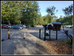 Parking Lot |
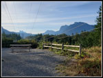 Mts. Baring & Index |
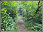 Cougar? |
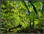
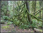 Mossy Trees |
 On The Road |
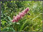
 Fireweed |
 View From Road |
 Ridge Across Valley |
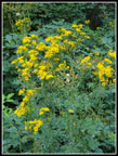 Yellow Daisies |
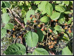 Ripe Blackberries |
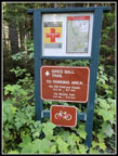 Greg Ball Trail |
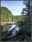 Wallace Lake Outlet |
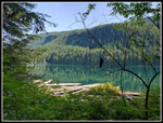 Wallace Lake |
 Wallace Lake Below |
 Clearcut View |
 Wide Angle Forest |
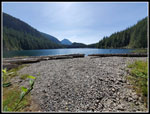 Many Pebbles Beach |
 Wallace From Inlet |
 Piles Of Rocks |
 Colorful Leaves |
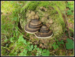 Shelf Fungus |
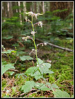 Foam Flower |
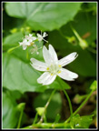 Spring Beauty |
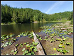 Jay Lake |
 Hovering Bee |
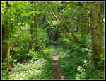 Heading For RR Grade |
 More Colorful Leaves |
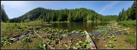 Jay Lake Panorama |
Trips - 2023
Home