12-23-23
I
was looking for a hike for my birthday. I needed it to be a long hike.
Last year I hiked over 1000 miles for the second time and first time in
30
years. I expected to drop to a more normal 800-900 mile year. The first
half was good. 900 miles was in sight. Then things picked up. By the
end of September I had a shot at my third best year with at least 961
mile. I averaged 95 miles per month for October and November and
started December needing 92 miles for a third 1000 year. The first
weekend was washed out by storms with rain and high winds. 1000 miles
looked to be out of range. I manged to get in two weekend and
a mid-week hike the next two weeks. With 9 days left in the year I was
39 miles short. That's why I needed a long day hike. I had one in
reserve that fit the bill. A long 17 mile road walk from Highway 18 to
the summit of West Rattlesnake Mountain. It is not scenic unless there
is some fresh snow on the trees and the upper road. Too much snow and
it is just not possible. If it is raining it's too long to be wet. The
elevation of the west peak is 3262'. Other nearby peaks at that
elevation were nearly snow free. Saturday was forecast to be cold and
clear. The conditions were excellent. Overnight it was cold with some
precipitation. I needed an early start since it was almost the shortest
daylight of the year. I was out the door at 6:48 am. Sunrise would be
at 7:55 am. Traffic was very light. It was 34F at home. It was sub
freezing most of the drive. I turned off I-90 onto Highway 18. There is
a left turn lane to where I park. Construction has the road down to one
lane in each direction. To turn left you must block all traffic until
there is an opening. I was relieved to find traffic light enough to
turn
easily. It was 34F when I parked at 7:25 am. Though it was half an hour
before sunrise, I could see just fine. There was no need for a headlamp.
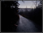
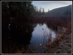
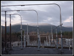
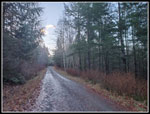
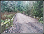
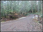
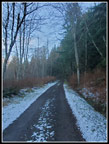
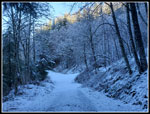
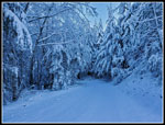
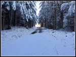
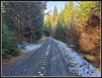
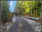
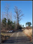
I headed for the paved road across the marsh at 7:29 am. Sometimes the first and second gates are open before Christmas so folks can cut their own Christmas tree if they buy a permit. This time the gates were closed. I would not be passed by any trucks. The first half mile is paved. The asphalt was mostly frozen. It was really slick getting across the marsh. All the potholes had frozen puddles. I felt fortunate when I made it across without falling. This hike can be made at a very fast pace. I have averaged under 20 minutes per mile while climbing 2500' several times. I needed to go fast this morning to warm up. There are mile and half mile markers up to the six mile mark. After that the road intersects another road and that roads mile markers are used. It makes it easy to see where you are. I passed the half mile marker and soon reached the big power sub-station. Just beyond is the 1 mile marker. The road remains flat past the 2 miles marker. It starts to climb and crosses a fairly new bridge over Canyon Creek. I was unable to do this trip for half a dozen years or so when the old giant culvert washed out. Just before and after the bridge are mountain bike trails. These are mostly downhill only trails which are not open to hikers. I hiked some of them while they were under construction.
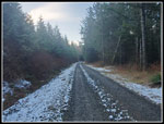
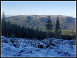
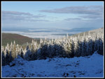
The road switches back and the next .70 miles is quite steep. At 3.30 miles the grade eases considerably. I was at about 1640' when I started to see a little snow on the sides of the road. Wait a minute, overnight snow down that low? That was not in the forecast. I did not bring poles or microspikes to save unneeded weight. I did have Yaktrax and gaiters. I still had 1600' to gain. How much snow would there be up high? I passed the 4 mile marker and continued hiking fast to the 4.5 mile marker. This marker is where the side road turns off and starts to climb. I hiked to the junction in 1:19. That is an average of 3.4 mph. For me, that is very fast. The new road starts to climb. In places it is moderate and in places it is steep. There is also one spot where it drops and climbs again. Before the 5 miles mark is a clearcut from about 10 years ago. I now had a clear view across to East Tiger Mountain. The summit is at 3007'. I could see the snow level on trees at about 2400'. It seemed that I would be on snow very soon.
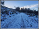
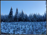
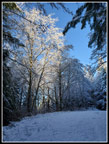
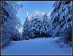
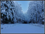
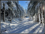
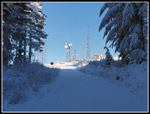
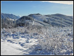
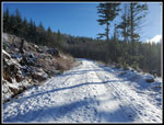
The road enters forest and switches back to the right. It get steep and goes back into a clearcut. Parts of the road were now covered with snow. It was soft in spots and thinner and icy in others. I stuck to the thicker snow and had good traction. After a couple bare and snowy sections the road switches back to the left and became totally snow covered. It was just a few inches deep at first and easy though slower walking. I could see East Tiger and now also the towers on West Tiger 1. Farther north the low valleys were under a layer of ground fog. I had blue sky overhead and some folks were in dark fog. The road kept climbing and then reached the quick drop and gain. At the bottom is the 6 mile marker. The road climbs more and just before 6.5 miles reaches the junction with the other main road. I look up here and saw that all the trees were heavily coated with fresh overnight snow. The sun was now high enough to touch the tops of the trees. They were really lit up. With the road covered with snow and the trees heavily snow laden the scenery was magical. It was dark in shade down low and the tree tops were such a bright white. I took a lot of photos. This was one of the best snow scenes I have seen. If I turned around here I would have been happy with the hike. From the junction I had only a little over 1.5 miles to go. On bare road I would have been to the summit within about 35 minutes. That was not going to happen this day.
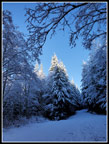
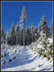
In forest, the snow was only 3"-4" deep. It was slower but not hard to keep moving. When I entered the new clearcut from just a couple years ago, it became deeper. Now it was 4"-6" deep. On the positive side it was nearly powder dry. We do not get snow like that near Puget Sound. It was easier to walk in than wet Seattle snow. The sun was blinding when walking towards it. The snow was unmarked. I passed several bike trails and they had no tracks. The road had some deer tracks up high but none lower down. It was fun to hike in unmarked fresh snow. I had great views out through the entire clearcuts. I am not a fan of them but that is one good side. From the bottom of the last two long switchbacks, I could see the summit towers right above. The road distance must have been more than 10 times the straight up distance. The snow covered slash and logs made straight up not a reasonable option. At the last right switchback I was only about 100' level feet from the Rattlesnake Mountain Trail. That would have been a shorter and easier route to the summit. I was out for miles and views, however. I just kept slogging up the road.
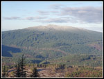
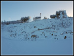
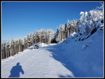
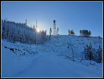
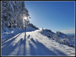
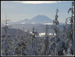
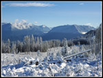
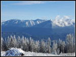
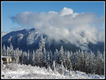
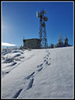
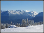
I rounded the last leftward switchback and could now see the towers just ahead. I decided to take the bike trail right to a viewpoint of Mt. Rainier. The sun was low in the sky and near Rainier so I was afraid it would be blown out. The trees in this clearcut are growing fast and partly block Rainier views. I did get in one photo that turned out. I headed back to the road and the final slog to the summit. I arrived on top at 10:59 am. I took 3:30 to summit. The first 4.5 miles took 1:19. The next 3.6 miles took 2:11. Partly it was the spectacular views and snow scenery. Partly it was the difficulty in setting steps in up to 6" of fresh snow. Traction was good and I was very happy to have the gaiters as the snow was deeper than the top of my low top hiking shoes. I hiked down to the lower towers for unobstructed views to the east. Mt. Si and Mt. Teneriffe were in clouds the whole time I was on top. The clouds were just on the upper mountains. Above them was blue sky. Mailbox was mostly in the clear. I could see the Middle Fork Snoqualmie peaks and Defiance, Washington, and the top of McClellan Butte. They were all covered with fresh snow on the upper mountains. The temperature felt like the low 30s. There was almost no wind. That made it comfortable. I went back to the summit and had lunch. With the views and sunshine I did not want to head down. Unfortunately, sunset was at 4:19 pm. Also, I needed to get home to host friends for my birthday and then Christmas movies.
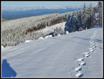
I headed down at 11:24 am. Downhill on snow is definitely easier than uphill. It was very comfortable in the sunshine. It was very cold in the shade. I was working less and generating less heat. At one point I cold see my lone footprints in the road below and I had half a mile of slogging to get there. At one spot I cold see Seattle with a field of white clouds in front of it. Just the downtown towers were visible. I definitely need a phone with more optical zoom to capture those shots. As I descended the snow depth lessened. My speed picked up as walking became much easier. I stopped for more photos at the main roads junction. There were still no tracks of feet or bikes. The photos there were still good though the tree tops were no longer lit up. I dropped down to the low spot at 6 miles and had one more short steep climb. Below 5.5 miles the road began to have a few bare spots. I stopped to take off my gaiters here. After the 5 mile marker the road was mostly bare. I reached the junction at 4.5 miles at 12:50 pm.
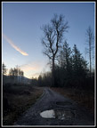
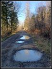
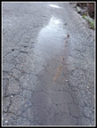
A 17 mile road walk is hard on my feet. Usually, the last 2-3 miles are hard. This day I felt great all the way down. Maybe 6 miles of hiking on soft snow helped. The extra effort needed did not wear me out. Before the .70 mile steep descent I took a short detour. It is 16.25 miles to the summit and back. To get 17 miles I need a detour. I first took this one several years ago. The new road heads over to a newish bridge over Canyon Creek. If I go just beyond the bridge and back it adds .75 miles. That brings me up to an even 17 miles. I took the detour and then the downhill back to the lower Canyon Creek Bridge. There is one more drop from the bridge to the flats and the last 2.3 miles to the car. I kept expecting to see a few hikers or bikers but there were none. I reached my car at 2:30 pm. It was in the shade and cold. It was a very cold 39F. It felt colder. The asphalt road across the marsh was still mostly icy.
For the day I hiked 17 miles with 2500' of gain in 7:01. The gps says that 59 minutes was while stopped. I came down in 3:07. That is pretty good with the snow. I ended up with some unexpected conditions. All that new snow and sunshine provided almost perfect conditions. Enough snow to make it look like mid winter but not deep enough on the road to keep me from hiking all the way up and down. What I thought would be a long road walk to get in miles for my attempt at 1000 miles turned out to be one where I took 230 photos of snowy goodness. It was a much better than expected day in the close in mountains.
Click on thumbnails to get
larger pictures.
Trips - 2023
Home
I headed for the paved road across the marsh at 7:29 am. Sometimes the first and second gates are open before Christmas so folks can cut their own Christmas tree if they buy a permit. This time the gates were closed. I would not be passed by any trucks. The first half mile is paved. The asphalt was mostly frozen. It was really slick getting across the marsh. All the potholes had frozen puddles. I felt fortunate when I made it across without falling. This hike can be made at a very fast pace. I have averaged under 20 minutes per mile while climbing 2500' several times. I needed to go fast this morning to warm up. There are mile and half mile markers up to the six mile mark. After that the road intersects another road and that roads mile markers are used. It makes it easy to see where you are. I passed the half mile marker and soon reached the big power sub-station. Just beyond is the 1 mile marker. The road remains flat past the 2 miles marker. It starts to climb and crosses a fairly new bridge over Canyon Creek. I was unable to do this trip for half a dozen years or so when the old giant culvert washed out. Just before and after the bridge are mountain bike trails. These are mostly downhill only trails which are not open to hikers. I hiked some of them while they were under construction.
The road switches back and the next .70 miles is quite steep. At 3.30 miles the grade eases considerably. I was at about 1640' when I started to see a little snow on the sides of the road. Wait a minute, overnight snow down that low? That was not in the forecast. I did not bring poles or microspikes to save unneeded weight. I did have Yaktrax and gaiters. I still had 1600' to gain. How much snow would there be up high? I passed the 4 mile marker and continued hiking fast to the 4.5 mile marker. This marker is where the side road turns off and starts to climb. I hiked to the junction in 1:19. That is an average of 3.4 mph. For me, that is very fast. The new road starts to climb. In places it is moderate and in places it is steep. There is also one spot where it drops and climbs again. Before the 5 miles mark is a clearcut from about 10 years ago. I now had a clear view across to East Tiger Mountain. The summit is at 3007'. I could see the snow level on trees at about 2400'. It seemed that I would be on snow very soon.
The road enters forest and switches back to the right. It get steep and goes back into a clearcut. Parts of the road were now covered with snow. It was soft in spots and thinner and icy in others. I stuck to the thicker snow and had good traction. After a couple bare and snowy sections the road switches back to the left and became totally snow covered. It was just a few inches deep at first and easy though slower walking. I could see East Tiger and now also the towers on West Tiger 1. Farther north the low valleys were under a layer of ground fog. I had blue sky overhead and some folks were in dark fog. The road kept climbing and then reached the quick drop and gain. At the bottom is the 6 mile marker. The road climbs more and just before 6.5 miles reaches the junction with the other main road. I look up here and saw that all the trees were heavily coated with fresh overnight snow. The sun was now high enough to touch the tops of the trees. They were really lit up. With the road covered with snow and the trees heavily snow laden the scenery was magical. It was dark in shade down low and the tree tops were such a bright white. I took a lot of photos. This was one of the best snow scenes I have seen. If I turned around here I would have been happy with the hike. From the junction I had only a little over 1.5 miles to go. On bare road I would have been to the summit within about 35 minutes. That was not going to happen this day.
In forest, the snow was only 3"-4" deep. It was slower but not hard to keep moving. When I entered the new clearcut from just a couple years ago, it became deeper. Now it was 4"-6" deep. On the positive side it was nearly powder dry. We do not get snow like that near Puget Sound. It was easier to walk in than wet Seattle snow. The sun was blinding when walking towards it. The snow was unmarked. I passed several bike trails and they had no tracks. The road had some deer tracks up high but none lower down. It was fun to hike in unmarked fresh snow. I had great views out through the entire clearcuts. I am not a fan of them but that is one good side. From the bottom of the last two long switchbacks, I could see the summit towers right above. The road distance must have been more than 10 times the straight up distance. The snow covered slash and logs made straight up not a reasonable option. At the last right switchback I was only about 100' level feet from the Rattlesnake Mountain Trail. That would have been a shorter and easier route to the summit. I was out for miles and views, however. I just kept slogging up the road.
I rounded the last leftward switchback and could now see the towers just ahead. I decided to take the bike trail right to a viewpoint of Mt. Rainier. The sun was low in the sky and near Rainier so I was afraid it would be blown out. The trees in this clearcut are growing fast and partly block Rainier views. I did get in one photo that turned out. I headed back to the road and the final slog to the summit. I arrived on top at 10:59 am. I took 3:30 to summit. The first 4.5 miles took 1:19. The next 3.6 miles took 2:11. Partly it was the spectacular views and snow scenery. Partly it was the difficulty in setting steps in up to 6" of fresh snow. Traction was good and I was very happy to have the gaiters as the snow was deeper than the top of my low top hiking shoes. I hiked down to the lower towers for unobstructed views to the east. Mt. Si and Mt. Teneriffe were in clouds the whole time I was on top. The clouds were just on the upper mountains. Above them was blue sky. Mailbox was mostly in the clear. I could see the Middle Fork Snoqualmie peaks and Defiance, Washington, and the top of McClellan Butte. They were all covered with fresh snow on the upper mountains. The temperature felt like the low 30s. There was almost no wind. That made it comfortable. I went back to the summit and had lunch. With the views and sunshine I did not want to head down. Unfortunately, sunset was at 4:19 pm. Also, I needed to get home to host friends for my birthday and then Christmas movies.
I headed down at 11:24 am. Downhill on snow is definitely easier than uphill. It was very comfortable in the sunshine. It was very cold in the shade. I was working less and generating less heat. At one point I cold see my lone footprints in the road below and I had half a mile of slogging to get there. At one spot I cold see Seattle with a field of white clouds in front of it. Just the downtown towers were visible. I definitely need a phone with more optical zoom to capture those shots. As I descended the snow depth lessened. My speed picked up as walking became much easier. I stopped for more photos at the main roads junction. There were still no tracks of feet or bikes. The photos there were still good though the tree tops were no longer lit up. I dropped down to the low spot at 6 miles and had one more short steep climb. Below 5.5 miles the road began to have a few bare spots. I stopped to take off my gaiters here. After the 5 mile marker the road was mostly bare. I reached the junction at 4.5 miles at 12:50 pm.
A 17 mile road walk is hard on my feet. Usually, the last 2-3 miles are hard. This day I felt great all the way down. Maybe 6 miles of hiking on soft snow helped. The extra effort needed did not wear me out. Before the .70 mile steep descent I took a short detour. It is 16.25 miles to the summit and back. To get 17 miles I need a detour. I first took this one several years ago. The new road heads over to a newish bridge over Canyon Creek. If I go just beyond the bridge and back it adds .75 miles. That brings me up to an even 17 miles. I took the detour and then the downhill back to the lower Canyon Creek Bridge. There is one more drop from the bridge to the flats and the last 2.3 miles to the car. I kept expecting to see a few hikers or bikers but there were none. I reached my car at 2:30 pm. It was in the shade and cold. It was a very cold 39F. It felt colder. The asphalt road across the marsh was still mostly icy.
For the day I hiked 17 miles with 2500' of gain in 7:01. The gps says that 59 minutes was while stopped. I came down in 3:07. That is pretty good with the snow. I ended up with some unexpected conditions. All that new snow and sunshine provided almost perfect conditions. Enough snow to make it look like mid winter but not deep enough on the road to keep me from hiking all the way up and down. What I thought would be a long road walk to get in miles for my attempt at 1000 miles turned out to be one where I took 230 photos of snowy goodness. It was a much better than expected day in the close in mountains.
 Dark But Not Completely |
 Dark Reflection |
 My Speed |
 Power Station |
 Some Light At Big Tree |
 Straight & Flat |
 Canyon Creek Bridge |
 Snow Begins |
 4.5 Mile Junction |
 Snow Alongside Road |
 In Shade, Road Is Snowy |
 Taylor Mountain? |
 East Tiger Mountain |
 Light On Tree Tops |
 Short Descent |
 Lit Up Trees |
 Really Lit Up |
 Main Road Junction |
 Flocked Trees |
 Fog Below |
 Summit In Sight |
 Deeper Snow |
 Untracked Snow |
 Less Snow In Trees |
 Sun Over Ridge |
 Shadows |
 Nearing Sunshine |
 Mt. Rainier |
 Blue Sky, My Tracks |
 Summit In Sight |
 View Northeast |
 Mailbox Peak |
 Mt. Si In The Clouds |
 East Rattlesnake Mt. |
 Summit Tracks |
 Mailbox To Defiance |
 Heading Down |
 Thinning Snow Cover |
 Little Snow Left |
 Upper Bridge |
 Big Puddles |
 Big Tree Again |
 Afternoon Is Still Icy |
Trips - 2023
Home