06-22-25
Gary
and John were free for a Sunday hike. I did a 15 mile hike three days
earlier. I was up for a trip but not a really grueling one. Sunday was
supposed to be mostly sunny but that changed at the last minute. We
decided on a trip north to Blanchard Hill and a route that had parts
that I had not hiked previously. Helping the decision was the fact
that two lanes of I-5 north at the ship canal bridge would be closed
all weekend. Going north was best. We met at Ash Way P&R at
6:55 am and headed north. The 70% morning overcast turned out to be
closer to 100%. We arrived at the Upper Blanchard Hill trailhead at
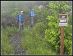
about 7:55 am. There were only a couple cars in the lot. At 8:04 am we
were on our way.
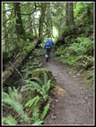
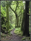
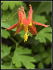
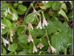
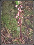
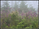
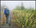
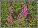
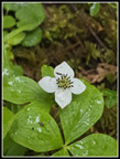
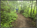
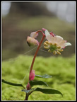
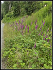
We headed down the road and onto the Lily Lake Trail. The trail was very green and the overcast improved the colors. Gary noticed some Indian pipe that was just coming out of the ground. In a few days they will look really good. We also saw some blooming columbine. We followed the trail to the first junction where we turned left on the Lily Max Connector Trail. I had been down this trail but not up it. We started to feel either tree drip or rain. It was sight enough we did not need jackets. At the next junction we went left. To the right is Max's Shortcut Trail and to the left is the Larry Reed Trail. I had not been on the latter. This route would take us to the Samish Overlook. We stared seeing lots of twinflower and foamflower. We also had some open sections out of forest and some brushy wet sections. The open logged sections had blooming foxglove. We would see a lot of it on this trip. We also saw some fresh purple coralroot.
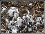
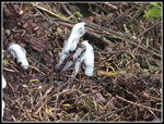
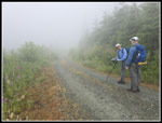
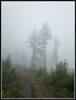
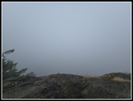
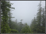
We reached a logging road that might be our route on the way back. We also passed the road to Samish Overlook. A little more forest and we reached the Overlook at 9:20 am. I had been there once before with Gary on a hike to Oyster Dome from Chuckanut Drive. We had great views on that day. We had a view of clouds in all directions this day. We managed to spend 12 minutes taking a break. The photos of the view were not epic. We decided to retrace our steps to the logging road instead of heading to the Oyster Dome Trail from the Overlook. It would be a new route for us and one that is much less crowded. On the way we found another patch of Indian pipe that were a little farther along. The logging road shows as the Acorn Trail on one sign and my map shows an Acorn Trail leaving the road just before it ends. As with roads in clearcuts, this time of year the planted foxglove, daisies, and buttercups were a mass of colors. We were in the clouds with minimal visibility along the road walk. I will have to come back sometime and find out if there are any views.
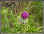
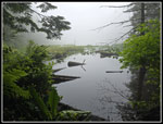
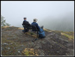
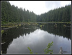
We finally came to the signed Acorn Trail. It looks to be pretty new with fresh gravel and new looking boardwalks. We were quickly back into forest. We saw bunchberries and a thistle along the way. A short hike brought us to Max's Shortcut Trail. We turned left and in .30 miles we reached the Lily Lake Trail. We were close to Lily Lake. There is a big meadow through trees near the trail. A few times it was a lake due to a beaver dam. Make that one more time. It was quite high. We would check that out a little later. Now we were on our way to Oyster Dome. The trail passes the trail to the lake and begins to descend. The forest was still misty as it had been all day. It was quiet until we reached the Oyster Dome Trail. As usual we we hikers coming and going on the .30 miles to the top. As we neared the top it was clear that it would not be in any way clear. There were several groups sitting on the slabs looking at the clouds. Visibility was about zero. Not even trees below were in sight. It was time to join the others for a break.
Hikers came and went during out stay. We arrived at 10:55 am and stayed until 11:11 am. That may have been my shortest stay. Even on a zero visibility day with a foot of snow I think I stayed longer. By this point, we had already hiked 6 miles. It was my longest hike just to reach Oyster Dome. We needed windshirts on top but I took mine off for the descent. For an early summer day it was cold, registering in the low 50s with a gentle cold breeze. We retraced our steps back to Lily Lake. From here on we did not see many people. A short way up the trail to Lily Lake we saw the new dam. It was farther down stream and a bit higher than the previous one some years ago.
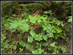
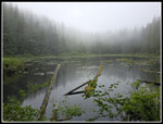
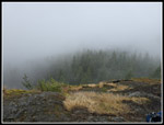
A very short way farther we saw a new permanent outhouse in place above the trail. It was still surrounded with straps as it is not yet open. It looks like a composting toilet like the one I see at the start of the Greg Ball Trail At Wallace Falls SP. With a campground at Lily Lake it is a nice addition. We crossed on the log to the end of the lake. Though it was very cloudy we could see to the end of the lake. As we were starting back I noticed a new bridge below us. It crosses the outlet creek to new campsites. They look very new. Quite a bit has changed here since my January 12 visit this past winter. We headed back to the main trail and followed it up the lake. We passed the older campsites. At the junction we went left and uphill towards North Butte. We stopped briefly on top for more photos of clouds. Even Oyster Dome just below was completely lost in the clouds. Next we took a short trail I noticed in January to a bench and viewpoint. On my previous visit, views out and down were just into white clouds. That day I had blue sky above. This day it was white in all directions. I will have to come back again to see what can be seen from this spot. The bench is bolted to a big rock slab. In front, it descends to a cliff. Do not slip or you will have a very long fall. I let Gary and John enjoy the bench while I sat on the rock next to it.
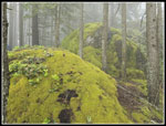
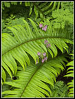
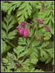
We arrived at the bench at 11:57 am and stayed until 12:13 pm. It seemed like a longer stay. Now we had an almost all downhill route. We dropped down to Lizard Lake. Along the way, we saw a lot of moss, blooming bleeding hearts, and more coralroot. We stopped for a few photos at the lake. One hiker was there are alerted us to a raptor in a tree. It was a bald eagle. Just before the campsites at the end of the lake there is a brand new outhouse still closed by straps around it. Both lakes now have new and very nice outhouses. We took the trail over to the four way junction. A right turn takes an old grade over to the top of the Lily Lake Trail. We came up the lower part of that trail in the morning. Left is the Caddis Fly bike trail over to a new clearcut. It was a great view of Mt. Baker but that would not exist on this cloudy day. The shortest return rout was straight ahead on the Alternate Incline Trail. It would take us down to a logging road/trail in 1 mile and then have 1 more mile back to the trailhead.
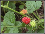
The trail is well graded and easy to descend. It has some logging equipment parts in places and is in forest all the way to the road. Our solitude continued along here. We saw some mushrooms and some slime mold. At the bottom we turn right on the gravel road. We saw some almost ripe salmonberries and some native blackberries. They are much smaller than the Himalayan variety that are all over vacant land in the lowlands. Most were still red but we did find a number of ripe black ones. At the old quarry there is one last opening in the trees with a view of Mt. Baker. There was no short or long range views. The clouds never did break up. We arrived at the car at 2:08 pm. The lot was nearly full though there were a couple cars parked along the road and room for more. For the day we ended up hiking just over 10 miles with 2000' of elevation gain. After 15 miles on Thursday that gave me 25 miles over the past four days.
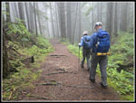
We hoped for a dry day and clearing skies in the afternoon. We had half of that. It was dry with a little tree drip and mist but it was solid clouds around us all day long. I hiked the Larry Reed and Acorn Trails for the first time. I aim for ten new trails per year so this helped there. The drive up took only one hour from Ash Way. The return had some slowdowns as expected. The one closed lane north of the Stillaguamish River has been going on for most of the year. The delay was not too bad this day. Traffic delays added about 15-20 minutes to our drive but we were still home by late afternoon. We saw wildflowers and saprophytes but they were not prolific. We had crowds around Oyster Dome but not on most of our route. Views would have been nice but the dark misty forest was a delight on its own. All in all, it was a nice day for a lower elevation hike.
Click on thumbnails to get
larger pictures.
Trips - 2025
Home
We headed down the road and onto the Lily Lake Trail. The trail was very green and the overcast improved the colors. Gary noticed some Indian pipe that was just coming out of the ground. In a few days they will look really good. We also saw some blooming columbine. We followed the trail to the first junction where we turned left on the Lily Max Connector Trail. I had been down this trail but not up it. We started to feel either tree drip or rain. It was sight enough we did not need jackets. At the next junction we went left. To the right is Max's Shortcut Trail and to the left is the Larry Reed Trail. I had not been on the latter. This route would take us to the Samish Overlook. We stared seeing lots of twinflower and foamflower. We also had some open sections out of forest and some brushy wet sections. The open logged sections had blooming foxglove. We would see a lot of it on this trip. We also saw some fresh purple coralroot.
We reached a logging road that might be our route on the way back. We also passed the road to Samish Overlook. A little more forest and we reached the Overlook at 9:20 am. I had been there once before with Gary on a hike to Oyster Dome from Chuckanut Drive. We had great views on that day. We had a view of clouds in all directions this day. We managed to spend 12 minutes taking a break. The photos of the view were not epic. We decided to retrace our steps to the logging road instead of heading to the Oyster Dome Trail from the Overlook. It would be a new route for us and one that is much less crowded. On the way we found another patch of Indian pipe that were a little farther along. The logging road shows as the Acorn Trail on one sign and my map shows an Acorn Trail leaving the road just before it ends. As with roads in clearcuts, this time of year the planted foxglove, daisies, and buttercups were a mass of colors. We were in the clouds with minimal visibility along the road walk. I will have to come back sometime and find out if there are any views.
We finally came to the signed Acorn Trail. It looks to be pretty new with fresh gravel and new looking boardwalks. We were quickly back into forest. We saw bunchberries and a thistle along the way. A short hike brought us to Max's Shortcut Trail. We turned left and in .30 miles we reached the Lily Lake Trail. We were close to Lily Lake. There is a big meadow through trees near the trail. A few times it was a lake due to a beaver dam. Make that one more time. It was quite high. We would check that out a little later. Now we were on our way to Oyster Dome. The trail passes the trail to the lake and begins to descend. The forest was still misty as it had been all day. It was quiet until we reached the Oyster Dome Trail. As usual we we hikers coming and going on the .30 miles to the top. As we neared the top it was clear that it would not be in any way clear. There were several groups sitting on the slabs looking at the clouds. Visibility was about zero. Not even trees below were in sight. It was time to join the others for a break.
Hikers came and went during out stay. We arrived at 10:55 am and stayed until 11:11 am. That may have been my shortest stay. Even on a zero visibility day with a foot of snow I think I stayed longer. By this point, we had already hiked 6 miles. It was my longest hike just to reach Oyster Dome. We needed windshirts on top but I took mine off for the descent. For an early summer day it was cold, registering in the low 50s with a gentle cold breeze. We retraced our steps back to Lily Lake. From here on we did not see many people. A short way up the trail to Lily Lake we saw the new dam. It was farther down stream and a bit higher than the previous one some years ago.
A very short way farther we saw a new permanent outhouse in place above the trail. It was still surrounded with straps as it is not yet open. It looks like a composting toilet like the one I see at the start of the Greg Ball Trail At Wallace Falls SP. With a campground at Lily Lake it is a nice addition. We crossed on the log to the end of the lake. Though it was very cloudy we could see to the end of the lake. As we were starting back I noticed a new bridge below us. It crosses the outlet creek to new campsites. They look very new. Quite a bit has changed here since my January 12 visit this past winter. We headed back to the main trail and followed it up the lake. We passed the older campsites. At the junction we went left and uphill towards North Butte. We stopped briefly on top for more photos of clouds. Even Oyster Dome just below was completely lost in the clouds. Next we took a short trail I noticed in January to a bench and viewpoint. On my previous visit, views out and down were just into white clouds. That day I had blue sky above. This day it was white in all directions. I will have to come back again to see what can be seen from this spot. The bench is bolted to a big rock slab. In front, it descends to a cliff. Do not slip or you will have a very long fall. I let Gary and John enjoy the bench while I sat on the rock next to it.
We arrived at the bench at 11:57 am and stayed until 12:13 pm. It seemed like a longer stay. Now we had an almost all downhill route. We dropped down to Lizard Lake. Along the way, we saw a lot of moss, blooming bleeding hearts, and more coralroot. We stopped for a few photos at the lake. One hiker was there are alerted us to a raptor in a tree. It was a bald eagle. Just before the campsites at the end of the lake there is a brand new outhouse still closed by straps around it. Both lakes now have new and very nice outhouses. We took the trail over to the four way junction. A right turn takes an old grade over to the top of the Lily Lake Trail. We came up the lower part of that trail in the morning. Left is the Caddis Fly bike trail over to a new clearcut. It was a great view of Mt. Baker but that would not exist on this cloudy day. The shortest return rout was straight ahead on the Alternate Incline Trail. It would take us down to a logging road/trail in 1 mile and then have 1 more mile back to the trailhead.
The trail is well graded and easy to descend. It has some logging equipment parts in places and is in forest all the way to the road. Our solitude continued along here. We saw some mushrooms and some slime mold. At the bottom we turn right on the gravel road. We saw some almost ripe salmonberries and some native blackberries. They are much smaller than the Himalayan variety that are all over vacant land in the lowlands. Most were still red but we did find a number of ripe black ones. At the old quarry there is one last opening in the trees with a view of Mt. Baker. There was no short or long range views. The clouds never did break up. We arrived at the car at 2:08 pm. The lot was nearly full though there were a couple cars parked along the road and room for more. For the day we ended up hiking just over 10 miles with 2000' of elevation gain. After 15 miles on Thursday that gave me 25 miles over the past four days.
We hoped for a dry day and clearing skies in the afternoon. We had half of that. It was dry with a little tree drip and mist but it was solid clouds around us all day long. I hiked the Larry Reed and Acorn Trails for the first time. I aim for ten new trails per year so this helped there. The drive up took only one hour from Ash Way. The return had some slowdowns as expected. The one closed lane north of the Stillaguamish River has been going on for most of the year. The delay was not too bad this day. Traffic delays added about 15-20 minutes to our drive but we were still home by late afternoon. We saw wildflowers and saprophytes but they were not prolific. We had crowds around Oyster Dome but not on most of our route. Views would have been nice but the dark misty forest was a delight on its own. All in all, it was a nice day for a lower elevation hike.
 Road To Trail |
 On The Trail |
 Bent Tree |
 Indian Pipe |
 Colorful Berries |
 Columbine |
 Twinflower |
 Trillium |
 Samish Overlook Views |
 Coralroot |
 More Indian Pipe |
 Misty Road/Trail |
 Misty Foxglove |
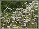 Daisies |
 Misty Trees |
 Muted Flowers |
 Fireweed |
 The Acorn Trail |
 A Thistle |
 A Bunchberry |
 Max's Shortcut Trail |
 Oyster Dome View |
 Very Green |
 Lily Lake |
 Lily Lake Different View |
 North Butte View |
 Bench On A Cliff |
 Best View Of The Day |
 Mossy Rocks |
 Tiny Flower |
 Bleeding Hear Sword Fern |
 Peak Bleeding Hearts |
 John & Jim |
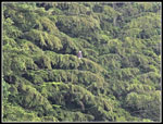 Bald Eagle |
 Lizard Lake |
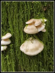 Mushrooms |
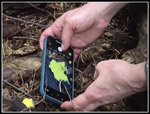 John & Slime Mold |
 More Foxgloves |
Trips - 2025
Home