06-19-25
Juneteenth
is a fairly new holiday and one that pertains to my business. For the
last few years it has been a midweek day for me to go hiking. The past
month I have done long drives east of the crest for wildflower hikes.
The forecast was for 75% overcast most of the day on the west side. I
chose to do a close in hike with no views. Since the weekend was
looking damp, I decided to get on a long hike. I chose a trip up East
Tiger Mountain via the long gated logging road. With two trips up the
.70 mile summit spur the trip is 15 miles with 2400' of gain. That
makes for a good leg stretcher. I last did this hike right after the
winter solstice. This trip would be right before the summer solstice.
That trip started just before sunrise. This trip would have 16 hours of
daylight. I drove east and then turned onto Highway 18. Construction
has been going on for quite some time. Traffic is now on the new west
side lines for both directions. I was early enough to miss heavy
traffic. I turned off the highway and parked well before the gate. It
was 7:28 am when I started out. Instead of the near total overcast I
had blue sky overhead.
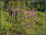
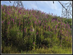
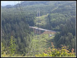
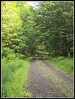
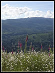
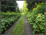
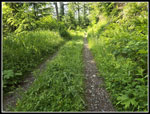
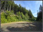
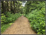
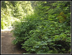
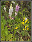
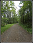
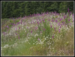
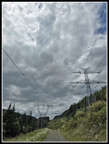
Some folks have the holiday day off work. Many do not. I wondered if I would see many people near the summit. It is 6.7 miles to the top of East Tiger gaining 2000'. That is not very steep. To make it more interesting, the first 3.1 miles does not gain much elevation. I set out lat a good pace with the temperature in the low 50s. The route starts by getting under the major powerlines feeding the cities. The cut is very wide allowing sun and wind with no breaks. This day I had a low but steady cold wind. The whole corridor was lined with foxglove and daisies. They were right at their peak. Throw in buttercups and it was very colorful. I could see the top of nearby West Rattlesnake Mountain but the Cascade peaks were in clouds. Where the route leaves the powerlines and enters forest I had a clear view down to the new bridge on Highway 18. The forest ended the wind and I began to warm up. In December, there were no leaves on trees or bushes. The grass was low and brown. Now, it was amazingly green. This continued all the way up. In places, the wide road was narrower with seven foot tall bushes impeding into the road. In places, the grass in the middle of the road was nearly waist high. I have never been here when it is to lush. It made for a very different experience than during fall through late winter when I usually hike this.
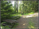
The road has mile and in places half mile markers that allowed me to know where I was without bothering to make another GPS track. Soon after the 1 mile marker I passed the junction with the Northwest Timber Trail at mile 1.3. I had already passed two bike trails and the barbecue grill that has been there for years. The road then drops and climbs back up. This is the biggest hill on the way back. I passed a sign saying they sprayed the clearcut I was entering a week earlier for noxious weeds. I had already eaten a few very ripe salmonberries. The sign suggested I do not do so the the next quarter mile. There is a view in the clearcut of Three Fingers Mountain. This day it was all clouds up that way. At 3.1 miles the road goes straight to another gate. This route used to to from Preston to the fire lookout on the summit of East Tiger. Now, the main route switchbacks sharply to the left and begins to climb. It is almost all uphill the last 3.6 miles to the top. I passed quite a few mountain bike trails along the way. Some of them I have hiked and some I have not. The big wide cement bridge is one landmark. I usually stop for food and water here. The creek was not flowing very high. The next landmark is where the Off The Grid Trail crossed the road and becomes the Fully Rigid Trail. Those trails go from the top of East Tiger to the Northwest Timber Trail just 1.3 miles from the car.
This day I wanted the shorter and less crowded road instead of the trails. That is that the trail up is longer than the road. The trail down is much shorter than the road. There are two picnic tables where the trails cross the road. I had been maintaining a good steady pace so far. It had warmed enough to go to a lighter shirt though it was still cool enough for me to hike fast. After crossing the top of the Quick Link Trail I heard some noise ahead and stopped. It was a lone deer just off the road eating breakfast. The tall grass hid here lower body. I stopped and took a few distant photos. I slowly walked ahead and came closer. I took more photos and kept walking. I was within about 20' when she finally walked into the woods. That was a nice treat. A few years ago I saw the only bobcat ever on this road. Now I came up close to a deer. Not bad for a road walk. The road reaches a high point and drops to the junction with the summit spur. Now I just had .70 miles to go and about 370' of gain.
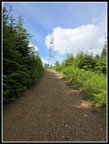
The spur road passes a lower viewpoint where I saw some distant bikers. Just after that is a trail to the summit. It is narrow and for hikers and uphill bikers only. I did not want to have those bikers pass me on the trail so I stayed on the road. It is flat in places then bears down to gain most of the elevation in the last half. I still felt good and just picked up my pace on the steep spots. Four bikers passed by. For the first 6 miles of my trip I saw one deer and no people. I did see lots of bikers near the summit even on a holiday many people do not get off. I reached the summit at 9:46 am. I took 2:18 to reach the top. Last December, I took 2:13 to summit. With all the flowers and the deer stop I took more photos on this trip. Five minutes longer with those stops meant I hiked at right about the same pace. 20.6 minutes per mile is a good uphill pace for me. The four bikers were on top and another one soon arrived. After a short break I headed down the road. Before reaching the bottom, I walked over to the lower viewpoint. Clouds had been moving in. It was still mostly blue overhead but views out were decreasing I could not see Mt. Rainier from the summit and I could not see it down lower. I went to the bottom of the road and went back uphill on the road to the high point. This added detour brought me fully up to 15 miles with 2400' of gain for the day.
This time I took the trail up to the summit. No bikes zipped on by me. I arrived on top to find new groups of bikers. Some passed me while I was descending and others took the road while I ascended on the trail. Now there were 7 or 8 bikers on top. That would be a good crowd on a weekend this early let alone on a weekday. I took a longer break this time. All the bikers were gone by the time I headed down at 10:52 am. So far, I had hiked 8.1 miles. It would be almost all downhill now. I continued to see random bikers until I was down to near the Off The Grid/Fully Rigid junction. I stopped at the picnic tables to empty rocks from a shoe and for a food and water break. I zoomed down to the big switchback and had just 3.1 miles to go. As logging roads go, this one is pretty soft but 15 miles is till a long way to go. With a couple miles left my feet were getting a little sore. When I popped out into the big powerline swath, the sky was now mostly dark gray. There was still a little blue to be seen. The overcast forecast was right but way to early.
I had another walk through the foxglove fields with much different lighting. I arrived back at the gate at 1:16 pm. My time down of 2:24 was slower than my ascent time. The same thing happened on my December trip. One of the most exciting parts of this trip is pulling out from a standing start into 60 mph traffic on a steep uphill. This time I was fortunate that a big gap allowed me to get up to speed without slowing down traffic. This trip provided just what I was looking for. A long hike close to home with total solitude for most of the trip. The flower show was much better than I expected. The deer sighting was really up close. The incredible amount of green near and on the road was unexpected. All that and I was done with the hike and heading home at 1:20 pm. It was a fun day on the road/trail.
Click on thumbnails to get
larger pictures.
Trips - 2025
Home
Some folks have the holiday day off work. Many do not. I wondered if I would see many people near the summit. It is 6.7 miles to the top of East Tiger gaining 2000'. That is not very steep. To make it more interesting, the first 3.1 miles does not gain much elevation. I set out lat a good pace with the temperature in the low 50s. The route starts by getting under the major powerlines feeding the cities. The cut is very wide allowing sun and wind with no breaks. This day I had a low but steady cold wind. The whole corridor was lined with foxglove and daisies. They were right at their peak. Throw in buttercups and it was very colorful. I could see the top of nearby West Rattlesnake Mountain but the Cascade peaks were in clouds. Where the route leaves the powerlines and enters forest I had a clear view down to the new bridge on Highway 18. The forest ended the wind and I began to warm up. In December, there were no leaves on trees or bushes. The grass was low and brown. Now, it was amazingly green. This continued all the way up. In places, the wide road was narrower with seven foot tall bushes impeding into the road. In places, the grass in the middle of the road was nearly waist high. I have never been here when it is to lush. It made for a very different experience than during fall through late winter when I usually hike this.
The road has mile and in places half mile markers that allowed me to know where I was without bothering to make another GPS track. Soon after the 1 mile marker I passed the junction with the Northwest Timber Trail at mile 1.3. I had already passed two bike trails and the barbecue grill that has been there for years. The road then drops and climbs back up. This is the biggest hill on the way back. I passed a sign saying they sprayed the clearcut I was entering a week earlier for noxious weeds. I had already eaten a few very ripe salmonberries. The sign suggested I do not do so the the next quarter mile. There is a view in the clearcut of Three Fingers Mountain. This day it was all clouds up that way. At 3.1 miles the road goes straight to another gate. This route used to to from Preston to the fire lookout on the summit of East Tiger. Now, the main route switchbacks sharply to the left and begins to climb. It is almost all uphill the last 3.6 miles to the top. I passed quite a few mountain bike trails along the way. Some of them I have hiked and some I have not. The big wide cement bridge is one landmark. I usually stop for food and water here. The creek was not flowing very high. The next landmark is where the Off The Grid Trail crossed the road and becomes the Fully Rigid Trail. Those trails go from the top of East Tiger to the Northwest Timber Trail just 1.3 miles from the car.
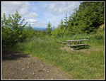
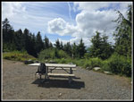
This day I wanted the shorter and less crowded road instead of the trails. That is that the trail up is longer than the road. The trail down is much shorter than the road. There are two picnic tables where the trails cross the road. I had been maintaining a good steady pace so far. It had warmed enough to go to a lighter shirt though it was still cool enough for me to hike fast. After crossing the top of the Quick Link Trail I heard some noise ahead and stopped. It was a lone deer just off the road eating breakfast. The tall grass hid here lower body. I stopped and took a few distant photos. I slowly walked ahead and came closer. I took more photos and kept walking. I was within about 20' when she finally walked into the woods. That was a nice treat. A few years ago I saw the only bobcat ever on this road. Now I came up close to a deer. Not bad for a road walk. The road reaches a high point and drops to the junction with the summit spur. Now I just had .70 miles to go and about 370' of gain.
The spur road passes a lower viewpoint where I saw some distant bikers. Just after that is a trail to the summit. It is narrow and for hikers and uphill bikers only. I did not want to have those bikers pass me on the trail so I stayed on the road. It is flat in places then bears down to gain most of the elevation in the last half. I still felt good and just picked up my pace on the steep spots. Four bikers passed by. For the first 6 miles of my trip I saw one deer and no people. I did see lots of bikers near the summit even on a holiday many people do not get off. I reached the summit at 9:46 am. I took 2:18 to reach the top. Last December, I took 2:13 to summit. With all the flowers and the deer stop I took more photos on this trip. Five minutes longer with those stops meant I hiked at right about the same pace. 20.6 minutes per mile is a good uphill pace for me. The four bikers were on top and another one soon arrived. After a short break I headed down the road. Before reaching the bottom, I walked over to the lower viewpoint. Clouds had been moving in. It was still mostly blue overhead but views out were decreasing I could not see Mt. Rainier from the summit and I could not see it down lower. I went to the bottom of the road and went back uphill on the road to the high point. This added detour brought me fully up to 15 miles with 2400' of gain for the day.
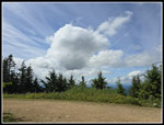
This time I took the trail up to the summit. No bikes zipped on by me. I arrived on top to find new groups of bikers. Some passed me while I was descending and others took the road while I ascended on the trail. Now there were 7 or 8 bikers on top. That would be a good crowd on a weekend this early let alone on a weekday. I took a longer break this time. All the bikers were gone by the time I headed down at 10:52 am. So far, I had hiked 8.1 miles. It would be almost all downhill now. I continued to see random bikers until I was down to near the Off The Grid/Fully Rigid junction. I stopped at the picnic tables to empty rocks from a shoe and for a food and water break. I zoomed down to the big switchback and had just 3.1 miles to go. As logging roads go, this one is pretty soft but 15 miles is till a long way to go. With a couple miles left my feet were getting a little sore. When I popped out into the big powerline swath, the sky was now mostly dark gray. There was still a little blue to be seen. The overcast forecast was right but way to early.
I had another walk through the foxglove fields with much different lighting. I arrived back at the gate at 1:16 pm. My time down of 2:24 was slower than my ascent time. The same thing happened on my December trip. One of the most exciting parts of this trip is pulling out from a standing start into 60 mph traffic on a steep uphill. This time I was fortunate that a big gap allowed me to get up to speed without slowing down traffic. This trip provided just what I was looking for. A long hike close to home with total solitude for most of the trip. The flower show was much better than I expected. The deer sighting was really up close. The incredible amount of green near and on the road was unexpected. All that and I was done with the hike and heading home at 1:20 pm. It was a fun day on the road/trail.
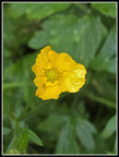 Buttercup |
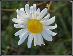 Daisy |
 Foxgloves In Bloom |
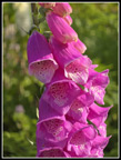 Foxglove Close Up |
 Many More Foxgloves |
 Highway 18 |
 Getting Very Green |
 Flowers & Rattlesnake Mt. |
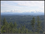 Cloudy Mountains |
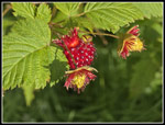 Ripe Salmonberries |
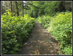 Overgrown Road |
 Big Bridge Break Time |
 More Grass Than Dirt |
 Road Is Very Grassy |
 Picnic Tables |
 Sunny At Quarry |
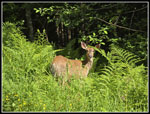 A Deer Friend |
 Summit Spur |
 Almost On Summit |
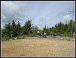 Bikers On Summit |
 Heading Down #1 |
 Lower Viewpoint |
 Neat Clouds |
 Alone On Top |
 Buried Sign |
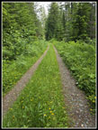 More Grassy Road |
 Clover |
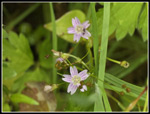 Spring Beauties |
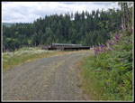 Bridge On Roadside |
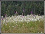 Daisies & Foxgloves |
 Multiple Flowers |
 Not Overgrown Road |
 Flower Field |
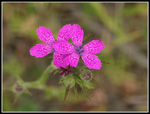 Deptford Pink |
 Gray Sky |
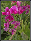 Peas |
Trips - 2025
Home