9-20-25
I
planned to hike the PCT to the Kendall Katwalk and Ridge Lake. I have
been painting my house this month and hiking has lagged. I hiked Tiger
1-2-3 on Friday for 9 miles with 2800' of gain. I needed a long hike
with good gain to help move this month from awful to poor. Last
Saturday I headed up I-90 and found out on the way that westbound the
road was down to one lane in Issaquah. It took me one hour to drive
less than 5 miles from Preston to Issaquah. Friday night I saw that the
construction closure would be in place again this weekend. I
immediately started looking for another hike with high elevation gain.
I came up with Mt. Dickerman. The downside is it has 3900' of gain
which would mean 6700' in about 24 hours. The steep downhill might be
worse than the climbing. I decided it would be Dickerman.
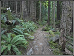
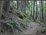
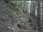
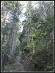
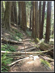
I was up at 5:35 am and out the door at 6:25 am. The drive was fine at that hour and I arrived at the trailhead at 7:55 am and on my way at 7:59 am. There were already 8 or 9 cars in the lot and three more came in right after me. It was about 50 degrees which was fine with me. The trail has a steady steep grade but I always forget about the many big steps. Where the new trail meets the old one, I noticed all the branches covering the closed trail. The tread still looked good after several decades. With the cars arriving just as I was starting, I expected to see some young hikers zoom past me soon. It did not happen. I tried to keep up a steady pace without going too fast. I felt a little tired at first than better. The forest is dark without a lot of ground cover. The switchbacks seem to go on forever. Even after 40 years hiking this trail I have few landmarks in the first two miles. It's just up, up, and more up. I noticed the old Big Four viewpoint and stopped for a water break there. The trees have grown to block much of the view. A lone hiker zipped on by me and she was quickly gone.
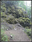
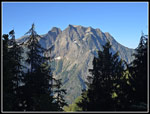
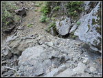
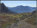
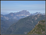
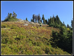
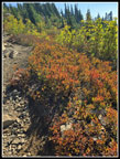
Two women passed me on their way down. They had a very early start. The next landmark is the right switchback that starts the long traverse to the left. Just after the switchback I noticed the old 2 mile marker on a tree. It is so faded it is hard to see. Another lone hiker passed me going down. He asked my age and it turns out he is 80. I really want to be able to do hikes of this gain when I am 80. I may have been the second oldest but he had me beat by a lot. Next I went under the overhanging big rock and then out of the trees for a moment with a partial view of Big Four Mountain. I soon had a better look at Big Four, Vesper, and Sperry Peaks. The creek crossing was totally dry as I expected. Going up the two sets of switchbacks the trail has been brushed nicely. I passed by the winter route and then turned uphill towards the meadow. I really dislike this part as it has big steps and solid deep gravel. The meadow itself still has a lot of ripe low bush blueberries. They were just past prime but still sweet.
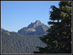
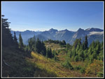
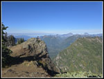
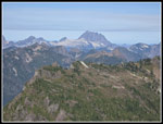
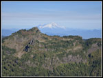
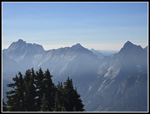
The trail follows the ridge over to below the summit. It provides a great view of Stillaguamish Peak and the meadow ridge leading to Mt. Forgotten. Forest gives way to more berry bushes alongside the trail. More bushes and more ripe berries. I was now beginning to feel all the elevation gain in the last 24 hours. The sun was out and I was really sweating now. The trail abruptly turns straight up the slope as the final climb begins. One fast hiker passed by and a couple groups were coming down. I ground out the last part and arrived at the summit at 10:30 am. To the west, the top of Mt. Pilchuck was in a dark haze. To the east both Mt. Pugh and Glacier Peak were the same. Everywhere else the sky was clear and the peaks were sharply visible. It was probably about 60 degrees but with the bright sunshine it felt much warmer but not hot. These were about perfect conditions. There were three or four others spread out along the summit ridge.
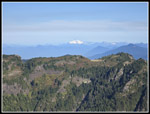
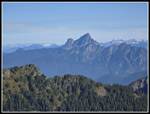
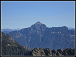
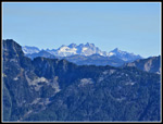
There are no really big mountains nearby to block the view. I could see Three Fingers and Whitehorse along with Mt. Baker, Shuksan, Eldorado, Dome, and Bonanza farther away. Stillaguamish, Forgotten, White Chuck, Pugh, Sloan, and the Monte Cristos were closer. Glacier Peak was in the middle distance. Glacier does not have much snow/ice showing on the southwest side. I could have spent the whole day up there. Unfortunately, the crowds were beginning to arrive. At 11:40 am I headed down. Having 1:10 on the summit was pretty good. My only stops going down were to sample the berries. The last month has been a great blueberry season. Some years are poor and every now and then you have a year like this one. I saw quite a few hikers coming up. As it should be on such a nice September day. All the big steps put a bit of s train on my knees but it did not hurt much on the way down. It was toasty in the open but the last half is all in forest and was much cooler.
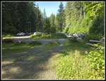
The last mile did seem to go and and on. I was pleased to reach the old/new trail junction. The last past is pretty gentle. I arrived at the parking lot at 1:52 pm to find the lot nearly full with cars parallel parked all the way around the edges. It was now in the low 70s. It did not take long for me to change shirts and dive into the comfortable air conditioned car. I had some slow traffic but nothing like one lane open on I-90. It was a good choice to go north.
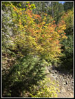
I considered doing a short hike to the Big Four ice caves but I was beat after 6700' of gain in 23 hours. I did get in 8 miles and 3900' of gain on the day. It is still a poor month but the in two days I nearly doubled my monthly miles and more than double elevation gain. The weather was nearly perfect, the views fantastic, the berries terrific, and I saw very few people on the way up. It was a really nice late summer day hike. In fact, the trip was only two days before the fall solstice. Bring on fall land golden larch trees!
Click on thumbnails to get
larger pictures.
Trips - 2025
Home
I was up at 5:35 am and out the door at 6:25 am. The drive was fine at that hour and I arrived at the trailhead at 7:55 am and on my way at 7:59 am. There were already 8 or 9 cars in the lot and three more came in right after me. It was about 50 degrees which was fine with me. The trail has a steady steep grade but I always forget about the many big steps. Where the new trail meets the old one, I noticed all the branches covering the closed trail. The tread still looked good after several decades. With the cars arriving just as I was starting, I expected to see some young hikers zoom past me soon. It did not happen. I tried to keep up a steady pace without going too fast. I felt a little tired at first than better. The forest is dark without a lot of ground cover. The switchbacks seem to go on forever. Even after 40 years hiking this trail I have few landmarks in the first two miles. It's just up, up, and more up. I noticed the old Big Four viewpoint and stopped for a water break there. The trees have grown to block much of the view. A lone hiker zipped on by me and she was quickly gone.
Two women passed me on their way down. They had a very early start. The next landmark is the right switchback that starts the long traverse to the left. Just after the switchback I noticed the old 2 mile marker on a tree. It is so faded it is hard to see. Another lone hiker passed me going down. He asked my age and it turns out he is 80. I really want to be able to do hikes of this gain when I am 80. I may have been the second oldest but he had me beat by a lot. Next I went under the overhanging big rock and then out of the trees for a moment with a partial view of Big Four Mountain. I soon had a better look at Big Four, Vesper, and Sperry Peaks. The creek crossing was totally dry as I expected. Going up the two sets of switchbacks the trail has been brushed nicely. I passed by the winter route and then turned uphill towards the meadow. I really dislike this part as it has big steps and solid deep gravel. The meadow itself still has a lot of ripe low bush blueberries. They were just past prime but still sweet.
The trail follows the ridge over to below the summit. It provides a great view of Stillaguamish Peak and the meadow ridge leading to Mt. Forgotten. Forest gives way to more berry bushes alongside the trail. More bushes and more ripe berries. I was now beginning to feel all the elevation gain in the last 24 hours. The sun was out and I was really sweating now. The trail abruptly turns straight up the slope as the final climb begins. One fast hiker passed by and a couple groups were coming down. I ground out the last part and arrived at the summit at 10:30 am. To the west, the top of Mt. Pilchuck was in a dark haze. To the east both Mt. Pugh and Glacier Peak were the same. Everywhere else the sky was clear and the peaks were sharply visible. It was probably about 60 degrees but with the bright sunshine it felt much warmer but not hot. These were about perfect conditions. There were three or four others spread out along the summit ridge.
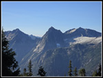
There are no really big mountains nearby to block the view. I could see Three Fingers and Whitehorse along with Mt. Baker, Shuksan, Eldorado, Dome, and Bonanza farther away. Stillaguamish, Forgotten, White Chuck, Pugh, Sloan, and the Monte Cristos were closer. Glacier Peak was in the middle distance. Glacier does not have much snow/ice showing on the southwest side. I could have spent the whole day up there. Unfortunately, the crowds were beginning to arrive. At 11:40 am I headed down. Having 1:10 on the summit was pretty good. My only stops going down were to sample the berries. The last month has been a great blueberry season. Some years are poor and every now and then you have a year like this one. I saw quite a few hikers coming up. As it should be on such a nice September day. All the big steps put a bit of s train on my knees but it did not hurt much on the way down. It was toasty in the open but the last half is all in forest and was much cooler.
The last mile did seem to go and and on. I was pleased to reach the old/new trail junction. The last past is pretty gentle. I arrived at the parking lot at 1:52 pm to find the lot nearly full with cars parallel parked all the way around the edges. It was now in the low 70s. It did not take long for me to change shirts and dive into the comfortable air conditioned car. I had some slow traffic but nothing like one lane open on I-90. It was a good choice to go north.
I considered doing a short hike to the Big Four ice caves but I was beat after 6700' of gain in 23 hours. I did get in 8 miles and 3900' of gain on the day. It is still a poor month but the in two days I nearly doubled my monthly miles and more than double elevation gain. The weather was nearly perfect, the views fantastic, the berries terrific, and I saw very few people on the way up. It was a really nice late summer day hike. In fact, the trip was only two days before the fall solstice. Bring on fall land golden larch trees!
 Gentle Grade At First |
 Minimal Ground Cover |
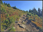
 Rock Steps |
 A Big Rock |
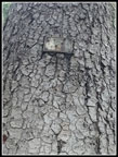 2 Mile Marker |
 Overhanging Rock |
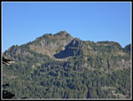
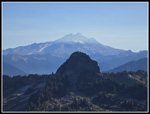
 Big Four Mountain |
 Dry Creek Bed |
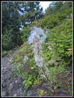 Fireweed |
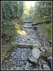 Rocks & Steps |
 Bright Colors |
 Mt. Forgotten |
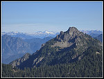
 Stillaguamish Peak |
 Looking South |
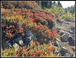 Great Colors! |
 Monte Cristo Peaks |
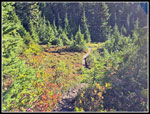
 Meadow Below |
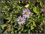 Two Asters |
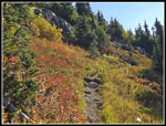 More Fall Colors |
 Nearing The Top |
 On The Summit |
 Three Fingers |
 Whitehorse Mountain |
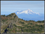
 Stillaguamish & Mt. Baker |
 Mt. Shuksan |
 White Chuck Mountain |
 Mt. Pugh |
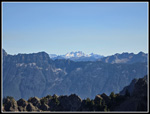 Dome Peak |
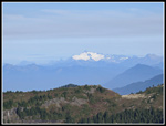
 Glacier Peak |
 Baker Up Close |
 Forgotten & Eldorado |
 Shuksan Zoomed In |
 Close Up Dome Peak |
 Heading Down |
 Hazy To The South |
 Juvenile Grouse |
 Fall Colors |
 Leaves Just Turning |
 Old Trail Junction |
 Lot Is Now Full |
Trips - 2025
Home