7-05-25
Gary
and John were free for a hike over the 4th of July holiday weekend. We
chose to hike Saturday, the middle day. Traffic is usually lightest. I
did a 6 mile hike viewing saprophytes on Friday. We met at Sunset Way
in Issaquah and I drove us east. Traffic was not bad as we had hoped.
We headed through Roslyn and up beyond Cle Elum Lake. The lake bed was
full of people camping. The turnoff to Cooper Lake was filled with cars
and trucks parking in lots. Gary and I last hiked this loop in 2000
only a few months after the Covid lockdown ended. The lot was over full
at 8:00 am in mid July that time. We arrived to find the lot overfull
at 7:57 am. There were four or five open spaces in the lot. Late
arrivers on Friday parked along the road in. Late leavers created a few
spaces. We took advantage and parked near the trailhead. It was low 50s
heading for the low 70s. A great early summer day before the heat
arrived to this area. We were packed and on the trail at 8:10 am. We
quickly reached a spot with a view down to the Cooper River. We would
only see it a few times all day. There are several good sized ups and
downs in the first mile. They were not a problem in the morning. After
12 miles they were not appreciated near the end of the day. There were
quite a few small creek crossings between the start and Pete Lake as we
would find out in the afternoon. There were only a few in the first
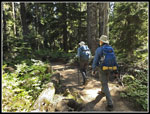
mile. Some were wide but none could not be crossed with dry feet. We
passed one hiker coming out in this section. He would be the only
person seen for many more hours.
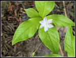
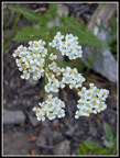
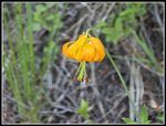
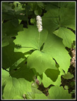
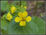
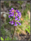
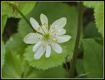
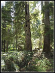
At the 1.3 mile point we reached the junction with the trail up Tired Creek. The lower section was the brushiest of the day, It gets just a fraction of the use that the Pete Lake Trail has. We saw a few wildflowers in the first 1.3 miles and more now. Rose, queen's cup, thimbleberry, and bunchberry were seen early. The next section added in columbine and spirea. The trail reaches an old road and we turned right. A short way along is a removed culvert or bridge and where the trail heads uphill. Decades ago when I hiked this it was a recent clearcut and the trail was a rocky mess at first. Now it is forested and much better. The trail starts out quite steep through the old clearcut and then settle down to switchbacks when it reaches the old trail. The forest shade was appreciated as this southern exposure would be quite hot otherwise. The day was already warming up. Soon we saw the first tiger lily of the day. John saw some stonecrop that Gary and I missed and it was the only stonecrop of the day. Tall purple penstemon started to appear along with starflowers. We had a narrow view out to snowy Four Brothers and Chikamin Peak.
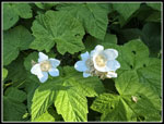
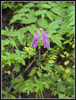
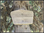
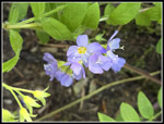
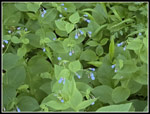
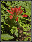
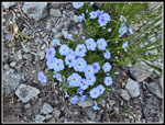
Next, was a view of the top of Mt. Rainier. The rest of the mountain was blocked by clouds. The forecast had a 42% morning overcast dropping in half in the afternoon. We had all blue sky overhead. This trail gains most of its elevation in the lower half. It was a steady grind going up. Valerian started appearing along with some more views out to Chikamin Peak and then the top of Three Queens Mountain. Lupine appeared next. We saw it off and on much of the day. I saw some yellow arnica and more smaller yellow flowers. I was looking for the Wilderness sign and I did notice it. It is the smallest one I have seen. It is very weathered and is likely one of the oldest ones too. Soon the switchbacks ended and the grade eased considerably. The flower show continued with a single purple trillium still blooming. We saw bluebells and shooting stars. Then came vanilla leaf, Jacob's ladder, Indian paintbrush, and yellow violets. Open areas showed lupine, penstemon, arnica, and Tiger lilies.
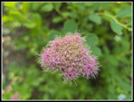
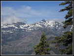
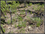
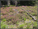
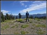
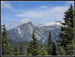
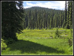
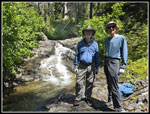
We soon saw the bigger meadows. They were filled with shooting stars, elephant's head lousewort, and heather. As has been the case this spring and early summer, the wildflower display slows us down a lot. After the meadows we headed for the Polallie Ridge trail. We reached the junction at 10:54 am. We had a short break in the shade before heading up the last short bit to the old Polallie Lookout site. The bugs were noticeable at the junction. They were much worse at the lookout site. We arrived at the 5482' lookout at 11:01 am. The views are great. On my first visit in 1992 the view was nearly all around. The trees have grown in the intervening 33 years. Now you have to move around to see peaks from Three Queens to Mt. Daniel to Mt. Stuart and beyond. The mosquitoes were really bad. I put on my windshirt with a hood. That helped a little. On the positive side, the bugs were less bad everywhere else on this hike. Early summer is great as most peaks had glaciers or snow still on the slopes. The contrast with rock was outstanding. We managed to hang on until 11:30 am. We had only hiked about one third of the way but had most of the elevation gain done. Our next leg took us down the Polallie Ridge Trail to Waptus Pass.
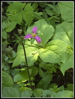
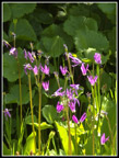
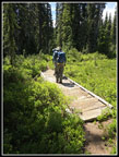
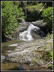
Lots of trees have fallen on this section over the years. There were not many newly fallen ones. We had no trouble with the few we had to get over around. The fallen trees have created more sunny spots than I recall. It was getting toasty in the open it was not too bad. At Waptus Pass we were back in some meadows. We saw more shooting stars, marsh marigolds, and some unusual light pink violets. One trail heads for Pete Lake and another goes down to Waptus Pass. There are several shot bridges across the meadows. Some were quite old and some have had recent work done. The Waptus Burn trail appeared next. It heads up to the Pacific Crest Trail. Next is the trail to Escondido Lake. Someday, I'll have to try one of them. This loop was long enough this day. From Waptus Pass the trail is relatively flat. There are ups and downs but no big ones. In 2020 Gary and I reached the Cooper River crossing to find a neat small waterfall upstream a short way. We ended up spending 1.5 hours there. The conditions were similar this year. There was a good wide flow but it was not deep. The level was low enough to have dry ground on one side up to a rock slab at the base of the falls/cascade. We arrived at 1:00 pm. There were bugs but a lot less than atop Polallie Ridge. It was time for another break.
It is a really nice spot. First, Gary noticed a frog. It hopped around but did not go far. Later, I noticed movement in the River. Below the falls is a flattish section then it drops again. The pool in between had at least three small fish. Now that was unexpected. The water was moving too much to get a really clear photo but we managed a few okay ones. We stayed until 1:58 pm. Almost an hour is a pretty long break. Surprisingly, we started the day hiking up the Cooper River. The water continues up to and beyond Pete Lake. We crossed the Cooper River well above Pete Lake. It turns out that Lemah Creek flows out of Pete Lake and meets the Cooper River downstream. From there it is the Cooper River. The Cooper River near Cooper Lake is big and wide. We rock hopped across at our break spot. The trail soon began to switchback and lose elevation. Before flattening out nearing the lake the trail loses 650' in .60 miles. It is rocky in places too. We made it down without anyone slipping. Near the bottom there are a couple waterfalls that are largely visible from the trail. After our break we started seeing hikers. We saw a couple then a bigger group of about six. After seeing nobody most of the day we started seeing the expected crowd near and below Pete Lake.
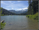
At the lake, it was not a madhouse on the middle day of the three day weekend. There were multiple open campsites. Some people must have left this day. We stopped at the shore for some photos of the lake and snowy peaks above. It was nice but we needed to keep moving. The last 4+ miles seemed to go on and one. We had lots of rock hop creeks to cross. One really wide rocky creek bed turned out to be the Cooper River. It must flow underground in this rock field as it nears the Lemah Creek/Cooper River junction. We passed some backpackers and day hikers heading to Pete Lake. The river may lose elevation between Peak and Cooper Lakes but we had more ups and downs. The last ones were not appreciated as we neared 13 miles. At 1.2 miles to go we closed our loop. We reached the parking lot at 5:13 pm. In 2020 we started at nearly the same time and finished at 5:12 pm. Quite a coincidence.
For the day we hiked 13.2 miles with about 3200' of elevation gain. It was a long day. We also took breaks at the lookout site and a longer one where we first reached the Cooper River. We saw three grouse up close, a frog, three fish, and heard woodpeckers. Add in all the wildflowers and the summit views and it was a very scenic day. Traffic was light going home so the middle day of the weekend worked out perfectly. This is not a trip I do every few years but I do try not let a decade go by. For all the views and flowers there is also a lot of solitude much of the way. Pete Lake is always crowded but the rest of the loop is not. It was a fun day in the mountains.
Click on thumbnails to get
larger pictures.
Trips - 2025
Home
At the 1.3 mile point we reached the junction with the trail up Tired Creek. The lower section was the brushiest of the day, It gets just a fraction of the use that the Pete Lake Trail has. We saw a few wildflowers in the first 1.3 miles and more now. Rose, queen's cup, thimbleberry, and bunchberry were seen early. The next section added in columbine and spirea. The trail reaches an old road and we turned right. A short way along is a removed culvert or bridge and where the trail heads uphill. Decades ago when I hiked this it was a recent clearcut and the trail was a rocky mess at first. Now it is forested and much better. The trail starts out quite steep through the old clearcut and then settle down to switchbacks when it reaches the old trail. The forest shade was appreciated as this southern exposure would be quite hot otherwise. The day was already warming up. Soon we saw the first tiger lily of the day. John saw some stonecrop that Gary and I missed and it was the only stonecrop of the day. Tall purple penstemon started to appear along with starflowers. We had a narrow view out to snowy Four Brothers and Chikamin Peak.
Next, was a view of the top of Mt. Rainier. The rest of the mountain was blocked by clouds. The forecast had a 42% morning overcast dropping in half in the afternoon. We had all blue sky overhead. This trail gains most of its elevation in the lower half. It was a steady grind going up. Valerian started appearing along with some more views out to Chikamin Peak and then the top of Three Queens Mountain. Lupine appeared next. We saw it off and on much of the day. I saw some yellow arnica and more smaller yellow flowers. I was looking for the Wilderness sign and I did notice it. It is the smallest one I have seen. It is very weathered and is likely one of the oldest ones too. Soon the switchbacks ended and the grade eased considerably. The flower show continued with a single purple trillium still blooming. We saw bluebells and shooting stars. Then came vanilla leaf, Jacob's ladder, Indian paintbrush, and yellow violets. Open areas showed lupine, penstemon, arnica, and Tiger lilies.
We soon saw the bigger meadows. They were filled with shooting stars, elephant's head lousewort, and heather. As has been the case this spring and early summer, the wildflower display slows us down a lot. After the meadows we headed for the Polallie Ridge trail. We reached the junction at 10:54 am. We had a short break in the shade before heading up the last short bit to the old Polallie Lookout site. The bugs were noticeable at the junction. They were much worse at the lookout site. We arrived at the 5482' lookout at 11:01 am. The views are great. On my first visit in 1992 the view was nearly all around. The trees have grown in the intervening 33 years. Now you have to move around to see peaks from Three Queens to Mt. Daniel to Mt. Stuart and beyond. The mosquitoes were really bad. I put on my windshirt with a hood. That helped a little. On the positive side, the bugs were less bad everywhere else on this hike. Early summer is great as most peaks had glaciers or snow still on the slopes. The contrast with rock was outstanding. We managed to hang on until 11:30 am. We had only hiked about one third of the way but had most of the elevation gain done. Our next leg took us down the Polallie Ridge Trail to Waptus Pass.
Lots of trees have fallen on this section over the years. There were not many newly fallen ones. We had no trouble with the few we had to get over around. The fallen trees have created more sunny spots than I recall. It was getting toasty in the open it was not too bad. At Waptus Pass we were back in some meadows. We saw more shooting stars, marsh marigolds, and some unusual light pink violets. One trail heads for Pete Lake and another goes down to Waptus Pass. There are several shot bridges across the meadows. Some were quite old and some have had recent work done. The Waptus Burn trail appeared next. It heads up to the Pacific Crest Trail. Next is the trail to Escondido Lake. Someday, I'll have to try one of them. This loop was long enough this day. From Waptus Pass the trail is relatively flat. There are ups and downs but no big ones. In 2020 Gary and I reached the Cooper River crossing to find a neat small waterfall upstream a short way. We ended up spending 1.5 hours there. The conditions were similar this year. There was a good wide flow but it was not deep. The level was low enough to have dry ground on one side up to a rock slab at the base of the falls/cascade. We arrived at 1:00 pm. There were bugs but a lot less than atop Polallie Ridge. It was time for another break.
It is a really nice spot. First, Gary noticed a frog. It hopped around but did not go far. Later, I noticed movement in the River. Below the falls is a flattish section then it drops again. The pool in between had at least three small fish. Now that was unexpected. The water was moving too much to get a really clear photo but we managed a few okay ones. We stayed until 1:58 pm. Almost an hour is a pretty long break. Surprisingly, we started the day hiking up the Cooper River. The water continues up to and beyond Pete Lake. We crossed the Cooper River well above Pete Lake. It turns out that Lemah Creek flows out of Pete Lake and meets the Cooper River downstream. From there it is the Cooper River. The Cooper River near Cooper Lake is big and wide. We rock hopped across at our break spot. The trail soon began to switchback and lose elevation. Before flattening out nearing the lake the trail loses 650' in .60 miles. It is rocky in places too. We made it down without anyone slipping. Near the bottom there are a couple waterfalls that are largely visible from the trail. After our break we started seeing hikers. We saw a couple then a bigger group of about six. After seeing nobody most of the day we started seeing the expected crowd near and below Pete Lake.
At the lake, it was not a madhouse on the middle day of the three day weekend. There were multiple open campsites. Some people must have left this day. We stopped at the shore for some photos of the lake and snowy peaks above. It was nice but we needed to keep moving. The last 4+ miles seemed to go on and one. We had lots of rock hop creeks to cross. One really wide rocky creek bed turned out to be the Cooper River. It must flow underground in this rock field as it nears the Lemah Creek/Cooper River junction. We passed some backpackers and day hikers heading to Pete Lake. The river may lose elevation between Peak and Cooper Lakes but we had more ups and downs. The last ones were not appreciated as we neared 13 miles. At 1.2 miles to go we closed our loop. We reached the parking lot at 5:13 pm. In 2020 we started at nearly the same time and finished at 5:12 pm. Quite a coincidence.
For the day we hiked 13.2 miles with about 3200' of elevation gain. It was a long day. We also took breaks at the lookout site and a longer one where we first reached the Cooper River. We saw three grouse up close, a frog, three fish, and heard woodpeckers. Add in all the wildflowers and the summit views and it was a very scenic day. Traffic was light going home so the middle day of the weekend worked out perfectly. This is not a trip I do every few years but I do try not let a decade go by. For all the views and flowers there is also a lot of solitude much of the way. Pete Lake is always crowded but the rest of the loop is not. It was a fun day in the mountains.
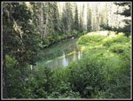 Cooper River |
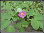 Rose |
 Queen's Cup |
 Bunchberry |
 Thimbleberry |
 Spirea |
 Penstemon |
 Starflower |
 Valerian |
 Tiger Lily |
 Chikamin Peak |
 Wilderness Sign |
 Jacob's Ladder |
 Bluebells |
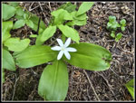
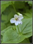 White Flower |
 Shooting Stars |
 Vanilla Leaf |
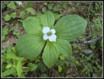
 Trillium |
 Red Indian Paintbrush |
 Yellow Violets |
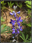 Lupine |
 Another Penstemon |
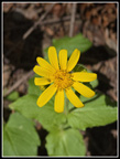 Arnica |
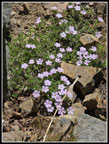 Phlox |
 Elephant"s Head |
 Elephant Faces |
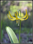 Glacier Lily |
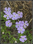 Pink Phlox |
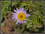 Aster |
 More Shooting Stars |
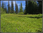 Big Meadow |
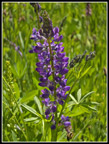 Nice Lupine |
 Blue Phlox |
 Mama Grouse |
 Heather Meadow |
 Gary & John At Lookout |
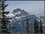 Three Queens |
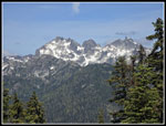 The Chiefs |
 Bears Breast & Hinman |
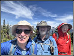 Us At Lookout Site |
 Hinman & Mt. Daniel |
 Bears Breast Mountain |
 Open Section |
 Pale Violets |
 Marsh Marigold |
 Waptus Pass Meadow |
 Boardwalk/Bridge |
 Break At Falls |
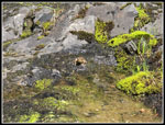 Frog |
 John, Gary & Falls |
 A Fish |
 Perfect Columbine |
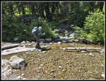 Gary Crosses River |
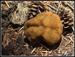 Mushroom |
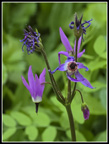
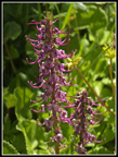
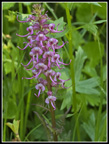
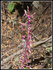 A Coralroot |
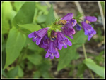 Last Penstemon |
 Holy Tree |
 Pete Lake & Peaks |
 Many Coralroot |
 Almost Finished |
Trips - 2025
Home