05-31-26
John
joined me for a long hike with
over 4000' of gain up the Middle Fork Snoqualmie River. I have done
South Bessemer 5 times. The first trips were in 2003 and 2004. The last
one was in 2021. It is a long road walk. The logging road starts in
very good shape. After the rock quarry it is in good shape. After the
turn onto another road at about 4.3 miles it is a rocky road. All my
previous visits had snow for at least the last mile. This time I was
not sure what we would find. It was a low snow winter but at the 5028'
summit there might still be some. We met in Issaquah and I drove to the
trailhead. On my previous visit there were no parking signs at the gate
but now there is just a Discover Pass sign. We parked near but not
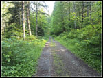
blocking the gate. We arrived at the 920' start at about 7:56 am. By
8:02 am were on our way. The first 1.1 miles are gently graded. There
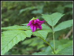
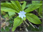
were some wildflowers immediately and more on and off on the way up. We
reached the CCC Road and went left to check out the bridge. I recall
crossing a narrow log with the top cut flat. We turned around and
headed east on the road. The main road turns left and uphill upon
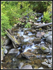
reaching the next creek. A big washout really messed up the
CCC a few years ago. Now there is a nice new bridge over the creek. The
bare dirt an rocks I recall post-washout is now covered with new brush
and small trees.
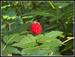
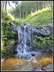
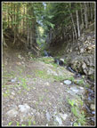
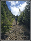
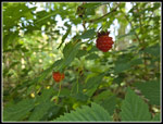
The road climbs at a steep grade above the CCC Road. We had seen some yellow and orange salmonberries earlier but now we were seeing some dark red ripe ones. We had to give them a try. Some were really sweet. That is not something I ofter saw about salmonberries. Or progress was slowed somewhat. The rock quarry came next. I recall when you could see it all from the road. Now, there are trees growing between the in and out roads. I checked post hike and it looks like the rocks were quarried higher on the mountain and stored here. It may no longer be in business. The road kept climbing and we were maintaining a pretty good pace. It was just over 40F at the start but it felt much warmer as we climbed higher. I recalled the road being pretty wide and open but it now is reverting to a wide trail in places. Mostly it is still road wide with brush on the sides. At 2000' the road crossed a previously washed out creek. The same one we saw when we left the CCC Road. It was pretty bare in 2021 but now had some growth around the creek and falls. The washout did open views to more the cascades farther upstream. We saw some starflowers here. The road switched back to the left again.
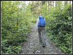
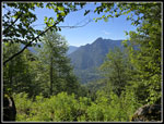
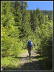
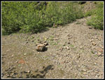
The next rightward switchback began a long traverse. We recrossed the previous creek again at a small falls. The grade was steadily moderate steep allowing us to keep up a pretty good pace. The next traverse was short and led to where we left the main road. There is a bit of an open space where the road heads off to the right. In 2021 I photographed at least half a dozen rock cairns here. This time none seemed to be standing. The GPS map confirmed the turn. The start was very rocky. The steep slope above was littered with small loose rocks and they periodically fall onto the old road. This road is not as wide or smooth as the main road below. It was also steeper. The 4.3 mile junction is at 3200'. So far we had climbed just under 2300'. We still had 1700' to go in the last 2.2 miles. The steepness and some loose small rocks slowed us down significantly. There are several shorter switchbacks in this section. Soon we started to have some small views out to the east and southeast. Two runners passed by going down. I did not expect to see anyone ahead of us. The sky was completely blue though some clouds were expected to come in by late morning.
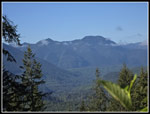
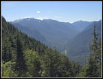
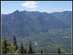
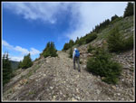
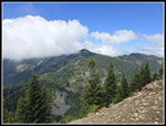
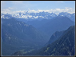
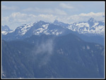
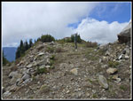
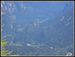
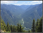
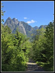
We took a food and water break at the good viewpoint just before the short spur to the saddle between South Bessemer and Moolock Mountains. South Bessemer blocked views to the north and northeast but the views were really good. Preacher Mountain dominated the view. To the right we could see the top of Caroline Mountain. The Middle Fork above the Taylor River was sitting far below. We were quickly back on our way. A few minutes later we reached the next junction. The route to the summit was to the right/straight. To the left is a short climb to the South Bessemer/Moolock Mountain saddle. I usually stop there fore a look at Moolock and north to other peaks. The open saddle I remembered is now full of small deciduous trees and brush. We did have a look north to Hancock's Comb and south to Russian Butte. We quickly dropped back down and continued up the road. The next section of road was mostly under snow on my previous visits. It is a steep rocky road on a steep hillside. It was steeper than I recalled. We were now mostly out in the open and it felt much warmer. When the road finally turned almost 180 degrees we were finally pointing to the summit. In 2021 Gary and I followed tracks on deep snow straight up the mountain. This time we stuck to the road. With a few twists and turns it rose up to the summit.
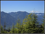
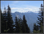
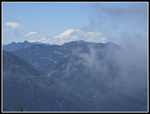
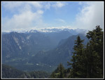
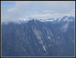
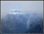
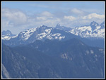
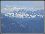
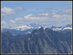
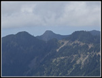
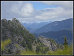
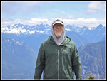
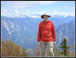
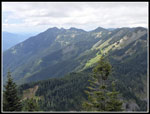
Nearer the top, we could look backwards and see the peaks of the Cascade Crest. South Bessemer is a great spot for views of the snowy crest peaks. Previously I had snowshoed straight up steep snow to the top. Now, for the first time, I saw that the road cut across the slope and angle up to the top. We arrived on top at 11:23 am. 3:21 is an average time for me. Unfortunately, the other times I was slogging in snowshoes and wearing my winter heavier boots. This time I had a light summer pack and low top hiking shoes. Age does slow me down a bit. It does not stop me from 13 mile 4100' day hikes. From the last 180 degree switchback, we started noticing clouds moving in. At the top the sky was getting whiter. The crest peaks had clouds behind them and some above but we still had clear views. We made sure to get photos quickly. Soon clouds blew in and out blocking views only to have them open up again. The peaks around us were mostly in clouds. Even nearby Moolock Mountain was hidden for a while. I never did see downtown Seattle. On a clear day to the west it is a very good though distant view. We never did see Mt. Baker. We saw the top of Mt. Rainier coming up but later it was engulfed in clouds. We saw one side of Glacier Peak though I was not able to identify it until I was at home.
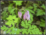
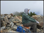
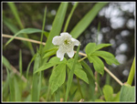
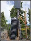
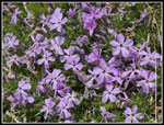
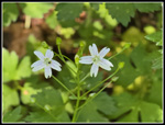
We decided to wait around for a hopeful clearing. In the meantime, we checked out some interesting flowers on top. One was a small white flower that seems to be some type of anemone. I do not recall ever having seen it before. An hour later another hiker reached the summit. That made three people seen. We headed over to the real summit. It is just a short drop and climb away. I had only seen it covered with snow. It is just a small dirt summit. There is a path up it. At the top we saw a strange item. A small wooden foundation has a corrugated plastic/vinyl tube on top with a cap on it. It says "Search + Rescue". I am not sure what it is. We went back to the big flat false summit again. We took more photos as the clouds moved in and out. A fourth hiker then reached the summit. We were ready to head down. We left the summit at 1:02 pm. At the first switchback I showed John where I had scrambled up the west side one time when it was snow free and we found a bunch of pink phlox. Without the short detour we never would have seen it.
The hike down was tougher up high as the steep rocky road required careful foot placement by us old guys. The view out were still really good as well. We took a short break at the viewpoint below the saddle and continued down. when we left the rocky summit spur road the going was easier. The main road gave us much smoother tread and gentler grade for the last 4.3 miles. Just above and below the quarry site, we again stopped for ripe salmonberries. There were lots of light red and orange ones still to ripen. As often happens, we saw a few more hikers in the last mile. We reached the gate at about 4:30 pm. With berry stops and the rocky road sections we took about the same amount of time hiking down as up.
This is one of those hikes that most people will never want to do. It is ling with a lot of gain and has few items of interest going up and down. The summit views are surprisingly good. They are best in the spring as the peaks still have some bright white snow on them. Four other hikers seemed about right for the summit. It is a good conditioning hike. I only managed two 4000' gain hikes last year. I was glad to get one in early this year. The sky was cloudier than forecast but we had good views early and in and out views later on. This is not an every year hike for me but well worth visiting every five or six years. It took me one hour to reach the trailhead from my home. With construction closing two lanes of I-90 at Hwy 18 it took two hours to get home. It was a small price to pay for a really nice day on a Middle Fork Snoqualmie summit.
Click on thumbnails to get
larger pictures.
Trips - 2026
Home
The road climbs at a steep grade above the CCC Road. We had seen some yellow and orange salmonberries earlier but now we were seeing some dark red ripe ones. We had to give them a try. Some were really sweet. That is not something I ofter saw about salmonberries. Or progress was slowed somewhat. The rock quarry came next. I recall when you could see it all from the road. Now, there are trees growing between the in and out roads. I checked post hike and it looks like the rocks were quarried higher on the mountain and stored here. It may no longer be in business. The road kept climbing and we were maintaining a pretty good pace. It was just over 40F at the start but it felt much warmer as we climbed higher. I recalled the road being pretty wide and open but it now is reverting to a wide trail in places. Mostly it is still road wide with brush on the sides. At 2000' the road crossed a previously washed out creek. The same one we saw when we left the CCC Road. It was pretty bare in 2021 but now had some growth around the creek and falls. The washout did open views to more the cascades farther upstream. We saw some starflowers here. The road switched back to the left again.
The next rightward switchback began a long traverse. We recrossed the previous creek again at a small falls. The grade was steadily moderate steep allowing us to keep up a pretty good pace. The next traverse was short and led to where we left the main road. There is a bit of an open space where the road heads off to the right. In 2021 I photographed at least half a dozen rock cairns here. This time none seemed to be standing. The GPS map confirmed the turn. The start was very rocky. The steep slope above was littered with small loose rocks and they periodically fall onto the old road. This road is not as wide or smooth as the main road below. It was also steeper. The 4.3 mile junction is at 3200'. So far we had climbed just under 2300'. We still had 1700' to go in the last 2.2 miles. The steepness and some loose small rocks slowed us down significantly. There are several shorter switchbacks in this section. Soon we started to have some small views out to the east and southeast. Two runners passed by going down. I did not expect to see anyone ahead of us. The sky was completely blue though some clouds were expected to come in by late morning.
We took a food and water break at the good viewpoint just before the short spur to the saddle between South Bessemer and Moolock Mountains. South Bessemer blocked views to the north and northeast but the views were really good. Preacher Mountain dominated the view. To the right we could see the top of Caroline Mountain. The Middle Fork above the Taylor River was sitting far below. We were quickly back on our way. A few minutes later we reached the next junction. The route to the summit was to the right/straight. To the left is a short climb to the South Bessemer/Moolock Mountain saddle. I usually stop there fore a look at Moolock and north to other peaks. The open saddle I remembered is now full of small deciduous trees and brush. We did have a look north to Hancock's Comb and south to Russian Butte. We quickly dropped back down and continued up the road. The next section of road was mostly under snow on my previous visits. It is a steep rocky road on a steep hillside. It was steeper than I recalled. We were now mostly out in the open and it felt much warmer. When the road finally turned almost 180 degrees we were finally pointing to the summit. In 2021 Gary and I followed tracks on deep snow straight up the mountain. This time we stuck to the road. With a few twists and turns it rose up to the summit.
Nearer the top, we could look backwards and see the peaks of the Cascade Crest. South Bessemer is a great spot for views of the snowy crest peaks. Previously I had snowshoed straight up steep snow to the top. Now, for the first time, I saw that the road cut across the slope and angle up to the top. We arrived on top at 11:23 am. 3:21 is an average time for me. Unfortunately, the other times I was slogging in snowshoes and wearing my winter heavier boots. This time I had a light summer pack and low top hiking shoes. Age does slow me down a bit. It does not stop me from 13 mile 4100' day hikes. From the last 180 degree switchback, we started noticing clouds moving in. At the top the sky was getting whiter. The crest peaks had clouds behind them and some above but we still had clear views. We made sure to get photos quickly. Soon clouds blew in and out blocking views only to have them open up again. The peaks around us were mostly in clouds. Even nearby Moolock Mountain was hidden for a while. I never did see downtown Seattle. On a clear day to the west it is a very good though distant view. We never did see Mt. Baker. We saw the top of Mt. Rainier coming up but later it was engulfed in clouds. We saw one side of Glacier Peak though I was not able to identify it until I was at home.
We decided to wait around for a hopeful clearing. In the meantime, we checked out some interesting flowers on top. One was a small white flower that seems to be some type of anemone. I do not recall ever having seen it before. An hour later another hiker reached the summit. That made three people seen. We headed over to the real summit. It is just a short drop and climb away. I had only seen it covered with snow. It is just a small dirt summit. There is a path up it. At the top we saw a strange item. A small wooden foundation has a corrugated plastic/vinyl tube on top with a cap on it. It says "Search + Rescue". I am not sure what it is. We went back to the big flat false summit again. We took more photos as the clouds moved in and out. A fourth hiker then reached the summit. We were ready to head down. We left the summit at 1:02 pm. At the first switchback I showed John where I had scrambled up the west side one time when it was snow free and we found a bunch of pink phlox. Without the short detour we never would have seen it.
The hike down was tougher up high as the steep rocky road required careful foot placement by us old guys. The view out were still really good as well. We took a short break at the viewpoint below the saddle and continued down. when we left the rocky summit spur road the going was easier. The main road gave us much smoother tread and gentler grade for the last 4.3 miles. Just above and below the quarry site, we again stopped for ripe salmonberries. There were lots of light red and orange ones still to ripen. As often happens, we saw a few more hikers in the last mile. We reached the gate at about 4:30 pm. With berry stops and the rocky road sections we took about the same amount of time hiking down as up.
This is one of those hikes that most people will never want to do. It is ling with a lot of gain and has few items of interest going up and down. The summit views are surprisingly good. They are best in the spring as the peaks still have some bright white snow on them. Four other hikers seemed about right for the summit. It is a good conditioning hike. I only managed two 4000' gain hikes last year. I was glad to get one in early this year. The sky was cloudier than forecast but we had good views early and in and out views later on. This is not an every year hike for me but well worth visiting every five or six years. It took me one hour to reach the trailhead from my home. With construction closing two lanes of I-90 at Hwy 18 it took two hours to get home. It was a small price to pay for a really nice day on a Middle Fork Snoqualmie summit.
 Starting Up Road |
 Thimbleberry Flowers |
 Big Blowout Creek |
 Foxglove |
 Salmonberry Flower |
 Red Salmonberry |
 Small Waterfall |
 Starflower |
 First Views |
 John On Narrowing Road |
 Creek Washout |
 Bleeding Hearts |
 Russian Butte View |
 Runner Coming |
 Preacher & Caroline |
 Mailbox Peak |
 Steep Rocky Road |
 View East |
 Cascade Crest Peaks |
 Yellow Violets |
 Clouds & Mt. Rainier |
 John Nearing Summit |
 Moolock Mountain |
 Upper MF Valley |
 Summit Chief To Chikamin |
 Garfield Mountain |
 Big Snow Mountain |
 John On False Summit |
 Very Cloudy |
 Summit Anemone |
 Big Slabs |
 Zoomed In Peaks |
 Crest Peaks |
 Hinman Daniel Garfield |
 Green & Teneriffe |
 Real Summit |
 Glacier Peak |
 John Near Summit |
 Stegosaurus Butte |
 John & Crest Peaks |
 Jim & Crest Peaks |
 Phlox |
 Ridge To Green Mt. |
 Pratt River Valley |
 Summit Road Junction |
 Spring Beauty |
 More Berries |
 Russian Butte Near End |
Trips - 2026
Home