01-24-26
Gary
and I were free for a hike.
With no snow in weeks we did not want a snow trip. On Monday we went
north to Chuckanut Mountain for snow free hike. This time we decided to
go for a trip we knew about but had never hiked. East of Bellingham on
the east side of Whatcom Lake is the Chanterelle Trail. 2.5 years ago a
new trail turned it into a 10.4 mile loop. We chose to take a look at
it. The trailhead is 90 miles from my house. Gary and I met at Ash Way
P&R at 6:30 am and headed north. Traffic was light at that
hour. We
left I-5 and went around the top of the lake and down to the
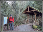
Chanterelle Trailhead. There were 3 cars in the lot when we arrived at
7:50 am. We chose to do the loop counterclockwise so we started going
downhill to the shore of Whatcom Lake on the Hertz Trail. At the
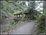
lakeshore we crossed the first of two covered bridges. The trail goes
along the lakeshore on an old railroad grade. It was about 28F and flat
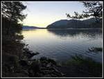
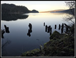
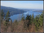
so went fast just to warm up. There are a few open views to the lake.
Lookout Mountain is across the lake and down a little. We saw a few
people on the trail. That accounted for most of the cars we saw.
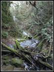
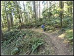
After a quarter mile of trail to the Hertz we had another 1.75 miles on the flats. In one spot there are still pilings for where the railroad went straight and the shore did not. Halfway along the Hertz Trail there is a waterfall. We took a short detour to a better view. At the junction with the new trail we stopped. We then went a short way farther to another covered bridge. We went back to the junction and started uphill. The grade is pretty steady without roots and rocks. We reached the well talked about stairs. There were quite a few sets of 6-24 steps. They are not tall and have plenty of room for feet. They are not bad at all. One major reason we went counterclockwise is that often steps are big with little room for feet. Going downhill is easier than I feared. In places the steps are steep but not too bad. That is the steepest part of the trip. In just under a mile, we reached the junction with the Lake Whatcom Overlook. The route drops a bit then goes up to the viewpoint. There is a nice bench for a break. We had pretty good views out to the Lake. We had hiked 2.75 miles and it was 9:19 am.
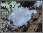
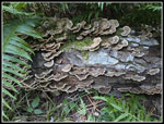
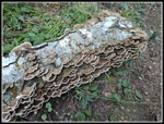
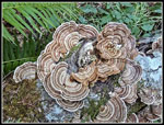
After a short break we headed back to the main trail. Below the stairways there were many short switchbacks. Above the junction there are longer switchbacks at a lower grade. Back at the Overlook junction, Gary noticed some hair ice. It only exists below freezing and it was in pretty good shape. It is always a treat to find some. It only occurs on fallen deciduous tree branches. Higher up Gary noticed a log next to the trail. It was covered entirely with peak turkeytail fungus. This was one of the best displays I have seen in years. Time was taken to try and get some good photos. There were no wildflowers and few mushrooms so the hair ice and turkeytails were an unexpected plus. The Whatcom County Parks site has a map that shows it is 3 miles from the Overlook junction to the next junction at the highest point on the loop. All the other trail sections checked out with Gary's GPS. This one did not. About 2.2 seems to be right.
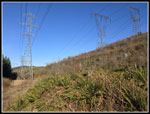
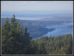
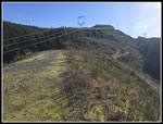
There was sunshine above us but the forest blocked almost all of it. It was over 32F but still pretty chilly. At one spot we had a little sunshine and we stopped there for a brunch break. Above us on the steep hillside it was totally in sunshine. So close but not close enough. The trail winds all around while slowly gaining elevation. At about 5.2 miles we reached the junction. The elevation was just over 2500'. A very short spur went up to the Whickersham Truck Trail. This starts at our trailhead and goes even farther. The Upper Chanterelle Trail starts here and descends to the left of the Whickersham Road/Trail. We looked at some viewpoints on the map that might lead to a view of Mt. Baker. We decided that our route was long enough. We started down the Upper Chanterelle Trail. There are a few bridges and mostly good tread. The forest continues almost all the way down. As we descended we came to a spot with a little forest then brush in sight. That was the powerline corridor above the Whickersham Road. It was in sunshine. Rather than stay in the cold dark forest we chose to leave.
It was not too bad getting through the down trees and then the short wall of brush. The sunshine felt about 30 degrees warmer. We had powerlines overhead but also the sunshine. We took our lunch break here. We did hear a couple runners or bikers zoom by on the trail. We were on an old spur just below the road. After lunch we headed up to the actual road. Another spur soon turned uphill to the top of the ridge. Now we had pretty good views to the north and west. Downtown Bellingham came into view. We could also see the Olympic Mountains. We descended the road to another trail. This trail went from the Chanterelle Trail, across the powerline corridor, and into woods at the top of the Brown Pow downhill only mountain biking trail. We headed back to the Chanterelle Trail. It was back to dark and cold but the trail was much softer dirt. The new Trail up from the lakeside Hertz Trail is hikers only. The Chanterelle and Upper Chanterelle is hikers both ways and bikes uphill only. We did start to see a few bikers as we descended. Lower down we saw bikes and hikers.
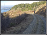
Our last destination was the Chanterelle Overlook. We popped out of the forest to find a grassy road with an open spot with views of the Lake and Bellingham. It was a lower and closer view of what we saw after lunch on the Wickersham Road/Trail. Below the viewpoint we saw more people. It is 2.4 miles from the trailhead to the Overlook viewpoint. That seems to be where most of the hikers go. That and the Hertz Trail along the lakeshore. In the last couple miles, the trail crosses the road several times. We finally popped out at the upper and smaller parking lot. We just had a minute or two walk back to the car in the lower larger lot. We arrived there at 2:18 pm. For the day we hiked about 10.4 miles with 2500' of elevation gain.
I am glad to have finally hiked this loop trail. The trails themselves are very good. They are pretty smooth with a moderate grade. The stairways were steeper but not that long. We had a whole lot of solitude going counterclockwise with an early start. The viewpoints were good but with mostly the same views of Whatcom Lake and then Bellingham. The forest is almost continuous. The shade would be nice on a hot summer day but a bit cold in the winter. I will need to come back in the later spring to see what the wildflower display is like. We were fortunate to have no traffic problems on the way home. I managed to get home a little before dark. Chuckanut Mountain and Blanchard Hill are shorter drives with more variety of trails but a 10.4 mile loop on very nice trail has appeal as well.
Click on thumbnails to get
larger pictures.
Trips - 2026
Home
After a quarter mile of trail to the Hertz we had another 1.75 miles on the flats. In one spot there are still pilings for where the railroad went straight and the shore did not. Halfway along the Hertz Trail there is a waterfall. We took a short detour to a better view. At the junction with the new trail we stopped. We then went a short way farther to another covered bridge. We went back to the junction and started uphill. The grade is pretty steady without roots and rocks. We reached the well talked about stairs. There were quite a few sets of 6-24 steps. They are not tall and have plenty of room for feet. They are not bad at all. One major reason we went counterclockwise is that often steps are big with little room for feet. Going downhill is easier than I feared. In places the steps are steep but not too bad. That is the steepest part of the trip. In just under a mile, we reached the junction with the Lake Whatcom Overlook. The route drops a bit then goes up to the viewpoint. There is a nice bench for a break. We had pretty good views out to the Lake. We had hiked 2.75 miles and it was 9:19 am.
After a short break we headed back to the main trail. Below the stairways there were many short switchbacks. Above the junction there are longer switchbacks at a lower grade. Back at the Overlook junction, Gary noticed some hair ice. It only exists below freezing and it was in pretty good shape. It is always a treat to find some. It only occurs on fallen deciduous tree branches. Higher up Gary noticed a log next to the trail. It was covered entirely with peak turkeytail fungus. This was one of the best displays I have seen in years. Time was taken to try and get some good photos. There were no wildflowers and few mushrooms so the hair ice and turkeytails were an unexpected plus. The Whatcom County Parks site has a map that shows it is 3 miles from the Overlook junction to the next junction at the highest point on the loop. All the other trail sections checked out with Gary's GPS. This one did not. About 2.2 seems to be right.
There was sunshine above us but the forest blocked almost all of it. It was over 32F but still pretty chilly. At one spot we had a little sunshine and we stopped there for a brunch break. Above us on the steep hillside it was totally in sunshine. So close but not close enough. The trail winds all around while slowly gaining elevation. At about 5.2 miles we reached the junction. The elevation was just over 2500'. A very short spur went up to the Whickersham Truck Trail. This starts at our trailhead and goes even farther. The Upper Chanterelle Trail starts here and descends to the left of the Whickersham Road/Trail. We looked at some viewpoints on the map that might lead to a view of Mt. Baker. We decided that our route was long enough. We started down the Upper Chanterelle Trail. There are a few bridges and mostly good tread. The forest continues almost all the way down. As we descended we came to a spot with a little forest then brush in sight. That was the powerline corridor above the Whickersham Road. It was in sunshine. Rather than stay in the cold dark forest we chose to leave.
It was not too bad getting through the down trees and then the short wall of brush. The sunshine felt about 30 degrees warmer. We had powerlines overhead but also the sunshine. We took our lunch break here. We did hear a couple runners or bikers zoom by on the trail. We were on an old spur just below the road. After lunch we headed up to the actual road. Another spur soon turned uphill to the top of the ridge. Now we had pretty good views to the north and west. Downtown Bellingham came into view. We could also see the Olympic Mountains. We descended the road to another trail. This trail went from the Chanterelle Trail, across the powerline corridor, and into woods at the top of the Brown Pow downhill only mountain biking trail. We headed back to the Chanterelle Trail. It was back to dark and cold but the trail was much softer dirt. The new Trail up from the lakeside Hertz Trail is hikers only. The Chanterelle and Upper Chanterelle is hikers both ways and bikes uphill only. We did start to see a few bikers as we descended. Lower down we saw bikes and hikers.
Our last destination was the Chanterelle Overlook. We popped out of the forest to find a grassy road with an open spot with views of the Lake and Bellingham. It was a lower and closer view of what we saw after lunch on the Wickersham Road/Trail. Below the viewpoint we saw more people. It is 2.4 miles from the trailhead to the Overlook viewpoint. That seems to be where most of the hikers go. That and the Hertz Trail along the lakeshore. In the last couple miles, the trail crosses the road several times. We finally popped out at the upper and smaller parking lot. We just had a minute or two walk back to the car in the lower larger lot. We arrived there at 2:18 pm. For the day we hiked about 10.4 miles with 2500' of elevation gain.
I am glad to have finally hiked this loop trail. The trails themselves are very good. They are pretty smooth with a moderate grade. The stairways were steeper but not that long. We had a whole lot of solitude going counterclockwise with an early start. The viewpoints were good but with mostly the same views of Whatcom Lake and then Bellingham. The forest is almost continuous. The shade would be nice on a hot summer day but a bit cold in the winter. I will need to come back in the later spring to see what the wildflower display is like. We were fortunate to have no traffic problems on the way home. I managed to get home a little before dark. Chuckanut Mountain and Blanchard Hill are shorter drives with more variety of trails but a 10.4 mile loop on very nice trail has appeal as well.
 Jim At 2nd Covered Bridge |
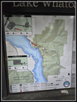 Map Of Trails |
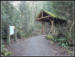
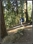
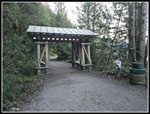 Arch Over Trail |
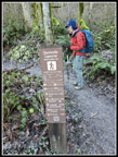
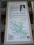 Hertz Trail Info |
 First Look At Lake |
 Waterfall |
 1st Covered Bridge |
 Old Train Pilings |
 2nd Covered Bridge |
 Trail Junction |
 Big Shelf Fungus |
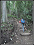 Trail Stairs |
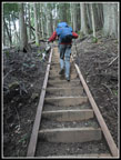 Steep Stairs |
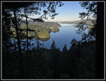 Whatcom Lake Overlook |
 Hair Ice |
 Turkeytail Log |
 Closer Look |
 Densely Packed |
 Circular Turkeytails |
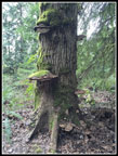
 Stump Face |
 Nicely Graded Trail |
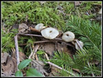 Mushrooms |
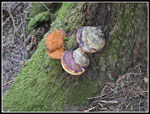 Great Colors |
 Into The Sunshine |
 View From Ridge Top |
 View Behind |
 Afternoon Ice |
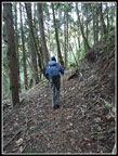
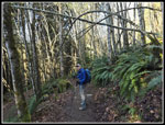
 Gary Heading Downhill |
 Upper Chanterelle Trail |
 Chanterelle Overlook |
 Gary On Chanterelle Trail |
 Trail Arch |
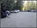 Trailhead Lot |
Trips - 2026
Home