01-31-26
Gary
was free for a hike. The
morning looked wet then it would improve. We came up with a couple
close in options and made a final decision in the morning. The end of
the rain looked to be several hours earlier than expected the night
before. We chose a trip we did once before in 2024. From the South
Tiger Mountain Trail starting point to South and Middle Tiger. On that
trip, Middle Tiger was being scalped. The TMT hit a new road and was
not found on the other side. We headed up the road and poked around to
find the trail. The summit was half clearcut opening up views to the
west, north and south. Mt. Rainier was clearly in view as well as
Seattle and the Olympic Mountains. I recalled views from the top in the
late 1980s but they were gone for at least 30 years. We took a new
trail down the back side and ended up climbing back to the summit
cross-country before heading back. On 10-30-25, Gary, John, and I did a
one way trip over South, Middle, and East Tiger ending at Tiger Summit.
By then the logging was done and the TMT crossed the road where we had
not found it earlier and climbed up and over the road to the top of
Middle Tiger. Even though we might not have any views we decided to
redo the Middle South Tiger hike again.
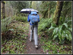
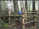
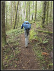
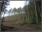
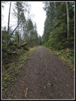
We met in North Seattle and Gary drove us via Highway 18. I believed the new Tiger Summit Trailhead would be open and wanted to take a look. On our one way South-Middle-East trip at the end of October workers were putting in the finishing touches. We arrived at Tiger Summit to find the gate closed and various signs about construction. It was a little after 8:00 am and closed. I don't think it is open yet. It was a short drove down to the TMT trailhead. There were already four cars there at 8:16 am when we started out. We had moisture on the drive and it was raining lightly at the beginning. It did not last long. We used umbrellas for the first mile or so but the rain had stopped before that. Usually when I do the South Tiger Circuit, I first hike up South Tiger and then take the TMT on the way back. This is on the other side of South Tiger and is all in forest except crossing the powerline corridor. The trail to the summit crosses the big new clearcut with great views out. Since we had a small hope that it might clear a bit later on, we took the TMT going out and would hope to have views coming back. First we reached the hiker/horse trail junction. We took the hiker trail going out. They met again where the loop around South Tiger begins. We went left on the TMT.
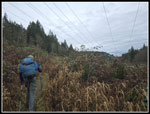
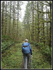
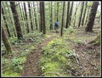
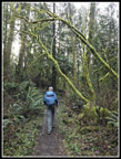
The TMT has one creek crossing that can be challenging after a lot of rain. The recent rain had little impact and it was an easy rock hop across. Next came the big powerline corridor. I only recalled the route under the powerlines then left and into forest. On our way back in 2024 we took a new trail that now just crosses the powerlines. I completely forgot about it. My website quickly refreshed my memory as I mentioned the new trail in my report. The TMT makes a very gentle ascent around South Tiger. It is on an old road and very smooth. By the time we reached the junction with the trail over the top of South Tiger it was 9:52 am and we had hiked 3.5 miles. The trail quickly reached the road from Tiger Summit to Poo Poo Point and crossed it. Back in the late 1980s this was the start of the TMT. We were in forest and the edge of a clearcut hiking over to the Connector Trail. That trail starts at the old train wreck site and now continues to Tiger Summit. I hike to the site on 2-23-25, which was the 100th anniversary of the wreck.
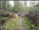
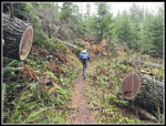
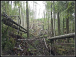
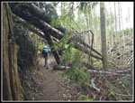
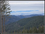
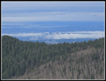
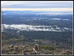
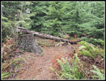
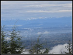
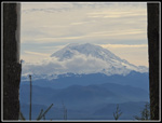
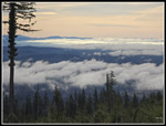
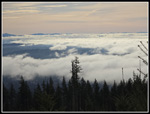
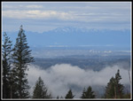
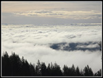
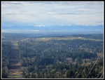
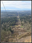
Before the most recent clearcut, the TMT took a big circle route around a forested mound. After the clearcut, a new much shorter trail goes on the near side of the mound. It makes it much shorter going to Middle Tiger. There are a lot of down trees from the big bomb cyclone in November 2024. Some are still over the trail but most have been out. We reached the road and crossed it. At the junction with the Middle Tiger Trail we turned right and uphill. The Middle Tiger Trail used to cross the TMT at a four way intersection. Now the old trail downhill is a little farther up the trail and not easily seen. We headed up to the road again and across. The old Middle Tiger Trail seems to be the same though now light comes in and there are a few views. The old trail was dark forest. We climbed to the ridge and then turned left following it to the summit. We arrived at 10:49 am having covered 5.2 miles. We started at 550' and the summit is at 2607'. Down below in the clearcut we could see several other hikers. They likely dropped down from Middle Tiger. While it was totally white sky above we had some views. Seattle and Bellevue were in and out of clouds. The Olympics were almost entirely in clouds. To the south we could see the white base of Mt. Rainier but most of the mountain was hidden.
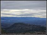
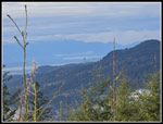
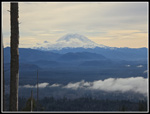
One hiker came up and then left while we were on top. The first wind of the day was on top., It was cold and steady but not gusting. With more clothing on it was fine. We packed up to leave at 11:12 am. We retraced our steps back to the trail wreck site and then to the West Side Road again. Just across we came to the junction of the TMT and the trail up and over South Tiger. We turned right and steeply uphill. It is all uphill from here to the summit. I very seldom do this trail in this direction. It feels much different. As we hiked the road/trail the sky became lighter. We eve began to see shadows. Perhaps our counterclockwise trip would yield some views after all. Where the old logging road ends we went straight ahead on the path to the summit of northern South Tiger Mountain. The top was scalped perhaps 15+ year ago. At first It had views of East Tiger and out to Mt. Si. Now it is completely covered with trees tall enough to block all views. We had a little more food and water and dropped back down. The southern South Tiger summit was much more recently clearcut. The trail has a fairly short climb to that summit and begins to drop. At and below the summit was had views out to Mt. Rainier. Now it was mostly in the clear. This is one of the best spots for a clear view of Mt. Rainier. From near the top we cold even see tall buildings in Seattle over the ridge of Squak Mountain.
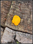
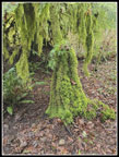
There are a lot of stumps alongside the trail along here and every one of them had witches' butter on them. I have never seen it on virtually every stump. The trail drops off South Tiger and into forest. The forest leads to another road and that drops to the powerline corridor again. We knew this would be our last spot in the sunshine. A quick break turned into a not so quick one. It was so much warmer in even a little sunshine. We then dropped down to the point where the hiker/horse trails met. In the morning we took the hiker trail. Now we took the horse trail. It is a little longer. It turned our loop into a figure eight. We went right around South Tiger and now left around a small bump until the trails met up again. That left us with just 1 mile to go. We saw few people in the morning but quite a few from South Tiger down. The trail had become more popular. We arrived back at the car at 3:12 pm. There were now 13 cars parked alongside the road.
We were prepared for an umbrella hike with no views and ended up with pretty good conditions. We did have some rain at first but it did not last long. We had some views from Middle Tiger but much better ones later on South Tiger. Farther north it did drain much of the day but we found a pretty good place for a 10.8 mile hike with 2700' of elevation gain. Middle Tiger has more appeal as a destination now that it has some very nice views.
Click on thumbnails to get
larger pictures.
Trips - 2026
Home
We met in North Seattle and Gary drove us via Highway 18. I believed the new Tiger Summit Trailhead would be open and wanted to take a look. On our one way South-Middle-East trip at the end of October workers were putting in the finishing touches. We arrived at Tiger Summit to find the gate closed and various signs about construction. It was a little after 8:00 am and closed. I don't think it is open yet. It was a short drove down to the TMT trailhead. There were already four cars there at 8:16 am when we started out. We had moisture on the drive and it was raining lightly at the beginning. It did not last long. We used umbrellas for the first mile or so but the rain had stopped before that. Usually when I do the South Tiger Circuit, I first hike up South Tiger and then take the TMT on the way back. This is on the other side of South Tiger and is all in forest except crossing the powerline corridor. The trail to the summit crosses the big new clearcut with great views out. Since we had a small hope that it might clear a bit later on, we took the TMT going out and would hope to have views coming back. First we reached the hiker/horse trail junction. We took the hiker trail going out. They met again where the loop around South Tiger begins. We went left on the TMT.
The TMT has one creek crossing that can be challenging after a lot of rain. The recent rain had little impact and it was an easy rock hop across. Next came the big powerline corridor. I only recalled the route under the powerlines then left and into forest. On our way back in 2024 we took a new trail that now just crosses the powerlines. I completely forgot about it. My website quickly refreshed my memory as I mentioned the new trail in my report. The TMT makes a very gentle ascent around South Tiger. It is on an old road and very smooth. By the time we reached the junction with the trail over the top of South Tiger it was 9:52 am and we had hiked 3.5 miles. The trail quickly reached the road from Tiger Summit to Poo Poo Point and crossed it. Back in the late 1980s this was the start of the TMT. We were in forest and the edge of a clearcut hiking over to the Connector Trail. That trail starts at the old train wreck site and now continues to Tiger Summit. I hike to the site on 2-23-25, which was the 100th anniversary of the wreck.
Before the most recent clearcut, the TMT took a big circle route around a forested mound. After the clearcut, a new much shorter trail goes on the near side of the mound. It makes it much shorter going to Middle Tiger. There are a lot of down trees from the big bomb cyclone in November 2024. Some are still over the trail but most have been out. We reached the road and crossed it. At the junction with the Middle Tiger Trail we turned right and uphill. The Middle Tiger Trail used to cross the TMT at a four way intersection. Now the old trail downhill is a little farther up the trail and not easily seen. We headed up to the road again and across. The old Middle Tiger Trail seems to be the same though now light comes in and there are a few views. The old trail was dark forest. We climbed to the ridge and then turned left following it to the summit. We arrived at 10:49 am having covered 5.2 miles. We started at 550' and the summit is at 2607'. Down below in the clearcut we could see several other hikers. They likely dropped down from Middle Tiger. While it was totally white sky above we had some views. Seattle and Bellevue were in and out of clouds. The Olympics were almost entirely in clouds. To the south we could see the white base of Mt. Rainier but most of the mountain was hidden.
One hiker came up and then left while we were on top. The first wind of the day was on top., It was cold and steady but not gusting. With more clothing on it was fine. We packed up to leave at 11:12 am. We retraced our steps back to the trail wreck site and then to the West Side Road again. Just across we came to the junction of the TMT and the trail up and over South Tiger. We turned right and steeply uphill. It is all uphill from here to the summit. I very seldom do this trail in this direction. It feels much different. As we hiked the road/trail the sky became lighter. We eve began to see shadows. Perhaps our counterclockwise trip would yield some views after all. Where the old logging road ends we went straight ahead on the path to the summit of northern South Tiger Mountain. The top was scalped perhaps 15+ year ago. At first It had views of East Tiger and out to Mt. Si. Now it is completely covered with trees tall enough to block all views. We had a little more food and water and dropped back down. The southern South Tiger summit was much more recently clearcut. The trail has a fairly short climb to that summit and begins to drop. At and below the summit was had views out to Mt. Rainier. Now it was mostly in the clear. This is one of the best spots for a clear view of Mt. Rainier. From near the top we cold even see tall buildings in Seattle over the ridge of Squak Mountain.
There are a lot of stumps alongside the trail along here and every one of them had witches' butter on them. I have never seen it on virtually every stump. The trail drops off South Tiger and into forest. The forest leads to another road and that drops to the powerline corridor again. We knew this would be our last spot in the sunshine. A quick break turned into a not so quick one. It was so much warmer in even a little sunshine. We then dropped down to the point where the hiker/horse trails met. In the morning we took the hiker trail. Now we took the horse trail. It is a little longer. It turned our loop into a figure eight. We went right around South Tiger and now left around a small bump until the trails met up again. That left us with just 1 mile to go. We saw few people in the morning but quite a few from South Tiger down. The trail had become more popular. We arrived back at the car at 3:12 pm. There were now 13 cars parked alongside the road.
We were prepared for an umbrella hike with no views and ended up with pretty good conditions. We did have some rain at first but it did not last long. We had some views from Middle Tiger but much better ones later on South Tiger. Farther north it did drain much of the day but we found a pretty good place for a 10.8 mile hike with 2700' of elevation gain. Middle Tiger has more appeal as a destination now that it has some very nice views.
 Rain At The Start |
 Powerline Corridor |
 TMT Around S. Tiger |
 In The Open |
 More TMT |
 Big Cut Log |
 Bomb Cyclone |
 Logs Over Trail |
 Ascending Middle Tiger |
 Downtown Seattle |
 Base Of Mt. Rainier |
 Bellevue In Clouds |
 Fog Below |
 Heading Down |
 Bare Ridge Of Middle T |
 Mushroom |
 Road Up South Tiger |
 South Tiger Summit |
 Olympic Peaks |
 Seattle Over Squak Mt. |
 Mt. Rainier Framed |
 Sun On Clouds |
 Rainier Again |
 Brighter Clouds |
 Seattle Port Cranes |
 Even Brighter |
 Witches' Butter |
 Tilted Sign |
 Powerline View |
 Powerlines Below |
 Mossy Trail |
 Moss To The Ground |
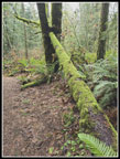 Last Mossy Log |
Trips - 2026
Home