06-13-26
Saturday
was forecast to be in the
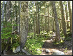
80s in Issaquah and a little cooler in the mountains. I chose a long
trip to two lakes. I last did this trip in 2023. I often take the Pratt
Lake Trail to Rainbow and Blazer Lakes. I much less often take the
longer route to Pratt and Lower Tuscohatchie Lakes. Most of the route
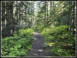
is in forest making it good for a hot day. The parking lot is not huge
and I expected people likely camped at the lakes Friday night. I was
not as early as I hoped but I did arrive at the trailhead at 7:38 am
and I was on my way at 7:44 am. The lot was mostly full but there were
still half a dozen spaces left and none along the road in. It was
already warming up but cool enough for easy hiking. The first thing I
noticed is that there are no free wilderness permits at the start. I
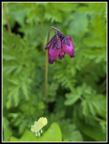
set a pretty good pace at first. I saw a couple blooming columbine
flowers at the half mile mark. Unfortunately, the photos were blurry.
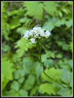
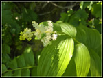
There were a lot of bunchberries and queen's cup flowers in the first
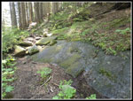
mile. I was concerned that the big creek at about 1.2 miles could be
high enough to make rock hopping difficult. That was not the case. Just
after the creek I saw one single saprophyte. I think it was a
coralroot. I passed two backpackers and a runner passed my. A little
later a runner passed by coming down. I did not see a lot of people on
my way up. I made it one mile before I zipped off my pants legs and
went to a short sleeve shirt. That made a big difference.
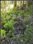
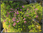
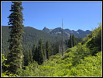
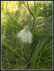
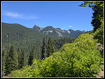
I saw some blooming lupine that were not a variety that I usually see. The long boardwalk/bridge is really in poor shape. multiple boards are no longer attached. I passed the turnoff to Olallie Lake and the grade eased. The small creeks were still running and I saw a bunch of marsh marigolds. Most were finished and a few more were almost done. I did see a few that were still fully blooming. I reached the crossing of the Olallie Lake inlet creek. It was an easy rock hop. The grade is very gentle as I headed for the Pratt-Defiance junction. A couple runners zoomed by me. I took a short water break at the Olallie Lake Overlook. In the last few years the growing trees have nearly blocked views of the lake. I could still see Mt. Rainier. I noticed this week that Mt. Rainier was been clear in the morning and also the afternoon. Usually clear morning lead to hazy afternoons. It was very clear is the morning. The trail then had a few partly blooming beargrass. They were the first I have seen this year. I reached the junction at 9:38 am. I had hiked about 4.1 miles with 2300' of gain. It was a small part of the mileage but most of the elevation gain.
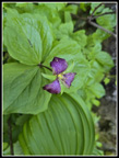
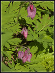
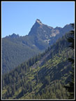
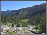
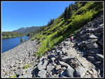
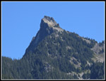
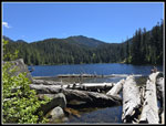
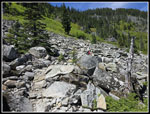
Now it was time to drop down to Pratt Lake. Many years ago the trail dropped steeply down to the lake. The reroute goes far to the left into a boulder field before traversing back. I can still find the where the old trail comes in but it is not at all obvious. On the descent I saw beargrass, Valerian, salmonberry, trillium, and bleeding heart flowers. It was not a great show but it was not bad. At the boulder field I was finally out in the open. It was getting pretty warm. I had my first view out tot Kaleetan Peak but I could not see Pratt Lake. It stays hidden until almost to the shore. It is a bit rockier than I recalled and while me knee does not hurt on uphills and flats it foes on big rocky steps down. After passing the old trail route, I was near the bottom. Then it is just an easy walk on to the lake. There was a little mud but it was not bad. I reached the open shore of Pratt Lake at 10:27 am. The lake shore trail has brush but also some sunny spots. Along the shore, I saw some very purple bleeding hearts, false Solomon seal, and a couple columbine. I planned to take the very short drop to the shore at the end of the lake for photos but a group was there.
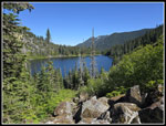
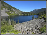
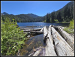
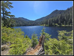
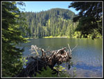
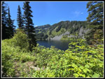
I passed the trail to the Pratt River. I doubt many of us have hiked that trail. The route over to Lower Tuscohatchie Lake climbs then drops. I had a lot of now closer looks across to Kaleetan Peak. Views down the river were mostly blocked by brush. A group started out a little behind me but they did not appear to have made it to Tuscohatchie. There were not many flowers along here except for yellow violets. I arrived at Lower Tuscohatchie at 11:02 am. I hiked a little over 6 miles in 3:18. I spent quite a bit of time in breaks and taking photos. I was not in a hurry this day. It was not getting quite warm. I did not wan to sit in the sunshine so I continued around the end of the lake. The first outlet has a bridge and the second one was an easy rock hop. As the trail starts to leave the lake heading for Melakwa Lake, I took a short side trail that drops to the lake shore. A big rootball now blocks a bit of the view but I could still see across the lake. My lunch spot was in the shade. Bugs were almost non-existent, which was a plus. I arrived at 11:08 am. I was in no hurry to head back. I was surprised to see three or four groups heading towards Melakwa.
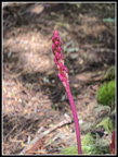
At 11:55 am I packed up and started back. I took a short detour at first to check out several campsites that were not seen from the trail. While there, I saw a patch of saprophytes. red and tall and I'm not sure what they were. I stopped for a few more minutes at the logjam at the far outlet. A few more minutes in the sunshine was nice. The hike back to Pratt Lake went fast. I stopped for more photos of Kaleetan. It is a very unique mountain and very photogenic. Back at Pratt Lake I planned to drop to the shore spot I missed in the morning. Now there was a bigger group with two dogs. This was not my day to get to the outlet spot. As I hiked along the lake I saw several more hikers coming in. The hike up through the boulder field was a bit tedious and now very warm. At the top of the boulders I stopped on the rocks in the shade. I had a great view down to the lake basin and up to Kaleetan Peak. My break was only for about 10 minutes. The climb back to the Defiance-Pratt junction was cool and enjoyable.
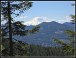
Once over the ridge top it was nearly all downhill back to the trailhead. At the Olallie Lake Overlook Mt. Rainier was still clear and not hazy at all. I was now 9 miles in with almost 4 miles to go. I saw hikers occasionally on the way out but it was never very crowded. The trailhead leads to Granite Mountain, Olallie and Talapus Lakes, and down the Defiance Trail. With an early start I was far from the trailhead while others hiked shorter routes. The last two miles were getting harder as all the rockiness took a toll on my knee. I reached the trailhead at 3:28 pm. For the day I hiked 13 miles with about 3100' of gain. It was about 80F at the finish. The trail is mostly in forest and that helped a great deal. The heat was not a problem. It was 87F when I drove through Issaquah making glad that I went a bit higher in the mountains for much better conditions. It was a great day in the mountains.
Click on thumbnails to get
larger pictures.
Trips - 2026
Home
I saw some blooming lupine that were not a variety that I usually see. The long boardwalk/bridge is really in poor shape. multiple boards are no longer attached. I passed the turnoff to Olallie Lake and the grade eased. The small creeks were still running and I saw a bunch of marsh marigolds. Most were finished and a few more were almost done. I did see a few that were still fully blooming. I reached the crossing of the Olallie Lake inlet creek. It was an easy rock hop. The grade is very gentle as I headed for the Pratt-Defiance junction. A couple runners zoomed by me. I took a short water break at the Olallie Lake Overlook. In the last few years the growing trees have nearly blocked views of the lake. I could still see Mt. Rainier. I noticed this week that Mt. Rainier was been clear in the morning and also the afternoon. Usually clear morning lead to hazy afternoons. It was very clear is the morning. The trail then had a few partly blooming beargrass. They were the first I have seen this year. I reached the junction at 9:38 am. I had hiked about 4.1 miles with 2300' of gain. It was a small part of the mileage but most of the elevation gain.
Now it was time to drop down to Pratt Lake. Many years ago the trail dropped steeply down to the lake. The reroute goes far to the left into a boulder field before traversing back. I can still find the where the old trail comes in but it is not at all obvious. On the descent I saw beargrass, Valerian, salmonberry, trillium, and bleeding heart flowers. It was not a great show but it was not bad. At the boulder field I was finally out in the open. It was getting pretty warm. I had my first view out tot Kaleetan Peak but I could not see Pratt Lake. It stays hidden until almost to the shore. It is a bit rockier than I recalled and while me knee does not hurt on uphills and flats it foes on big rocky steps down. After passing the old trail route, I was near the bottom. Then it is just an easy walk on to the lake. There was a little mud but it was not bad. I reached the open shore of Pratt Lake at 10:27 am. The lake shore trail has brush but also some sunny spots. Along the shore, I saw some very purple bleeding hearts, false Solomon seal, and a couple columbine. I planned to take the very short drop to the shore at the end of the lake for photos but a group was there.
I passed the trail to the Pratt River. I doubt many of us have hiked that trail. The route over to Lower Tuscohatchie Lake climbs then drops. I had a lot of now closer looks across to Kaleetan Peak. Views down the river were mostly blocked by brush. A group started out a little behind me but they did not appear to have made it to Tuscohatchie. There were not many flowers along here except for yellow violets. I arrived at Lower Tuscohatchie at 11:02 am. I hiked a little over 6 miles in 3:18. I spent quite a bit of time in breaks and taking photos. I was not in a hurry this day. It was not getting quite warm. I did not wan to sit in the sunshine so I continued around the end of the lake. The first outlet has a bridge and the second one was an easy rock hop. As the trail starts to leave the lake heading for Melakwa Lake, I took a short side trail that drops to the lake shore. A big rootball now blocks a bit of the view but I could still see across the lake. My lunch spot was in the shade. Bugs were almost non-existent, which was a plus. I arrived at 11:08 am. I was in no hurry to head back. I was surprised to see three or four groups heading towards Melakwa.
At 11:55 am I packed up and started back. I took a short detour at first to check out several campsites that were not seen from the trail. While there, I saw a patch of saprophytes. red and tall and I'm not sure what they were. I stopped for a few more minutes at the logjam at the far outlet. A few more minutes in the sunshine was nice. The hike back to Pratt Lake went fast. I stopped for more photos of Kaleetan. It is a very unique mountain and very photogenic. Back at Pratt Lake I planned to drop to the shore spot I missed in the morning. Now there was a bigger group with two dogs. This was not my day to get to the outlet spot. As I hiked along the lake I saw several more hikers coming in. The hike up through the boulder field was a bit tedious and now very warm. At the top of the boulders I stopped on the rocks in the shade. I had a great view down to the lake basin and up to Kaleetan Peak. My break was only for about 10 minutes. The climb back to the Defiance-Pratt junction was cool and enjoyable.
Once over the ridge top it was nearly all downhill back to the trailhead. At the Olallie Lake Overlook Mt. Rainier was still clear and not hazy at all. I was now 9 miles in with almost 4 miles to go. I saw hikers occasionally on the way out but it was never very crowded. The trailhead leads to Granite Mountain, Olallie and Talapus Lakes, and down the Defiance Trail. With an early start I was far from the trailhead while others hiked shorter routes. The last two miles were getting harder as all the rockiness took a toll on my knee. I reached the trailhead at 3:28 pm. For the day I hiked 13 miles with about 3100' of gain. It was about 80F at the finish. The trail is mostly in forest and that helped a great deal. The heat was not a problem. It was 87F when I drove through Issaquah making glad that I went a bit higher in the mountains for much better conditions. It was a great day in the mountains.
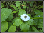 Bunchberry Flower |
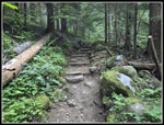 Early On The Trail |
 Granite Mt. Junction |
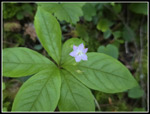 Starflower |
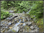 Biggest Creek Crossing |
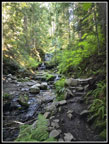 Shady Waterfalls |
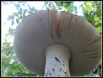 Mushroom |
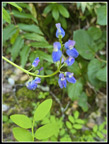 Lupine |
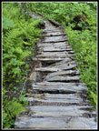 Broken Boardwalk |
 Valerian |
 Marsh Marigold |
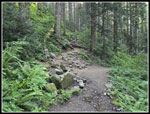
 Grade Flattens |
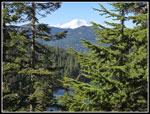 Rainier From Overlook |
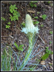
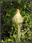 First Beargrass |
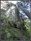 Strange View Up |
 Another Beargrass |
 Purple Trillium |
 Wed & Muddy Spot |
 First Bleeding Hearts |
 Kaleetan Peak In Sight |
 Heather |
 Lake Basin |
 Nearing Pratt Lake |
 View Of Pratt Lake |
 False Solomon Seal |
 Better Lake View |
 Runner Zips By |
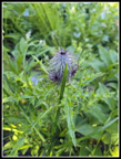 Thistle |
 Red Bleeding Hearts |
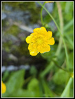 Buttercup? |
 Columbine |
 Big Slab |
 Trail To Tuscohatchie |
 Kaleetan Close Up |
 At Lower Tuscohatchie |
 Different View |
 More Beargrass |
 Lunch Spot |
 Red Saprophyte |
 Last Lake Break |
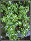 Bunch Of Bunchberries |
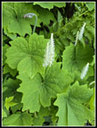 Vanilla Leafs |
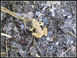 Frog |
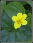 Yellow Violet |
 Heading Back To Pratt |
 Pratt Lake & Mountain |
 Boulder Field |
 Mt. Rainier View Again |
Trips - 2026
Home