3-01-26
Gary
was free for a Sunday hike.It
would be mostly sunny in the Seattle area and totally sunny farther
north. We decided on a long hike in Wallace Falls State Park. The only
problem was that removal of a fly over ramp from I-405 to Highway 522
would have 522 closed all weekend. Traffic on Saturday proved to be not
bad so we went for our usual meeting at Bothell Park and Ride. We met
at 6:55 am and took an unpublicized detour that only added a few
minutes. We arrived at the trailhead at about 7:37 am and were on the
trail at 7:44 am. It was sunny and a cool 31F. We started fast down the
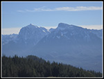
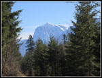
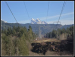
road under the powerlines trying to warm up. As always, we stopped for
the view of Mts. Baring, Index, and Persis. There was a lot of glare
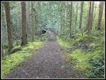
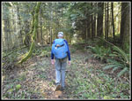
looking into the low morning suns. Then we were into the forest and out
of the sunshine for quite a while. We took the shorter Woody Trail
along the Wallace River rather than the longer Railroad Grade route. We
would be traveling far enough this day. There were more cars in the lot
than expected so early in the morning this early in the year. We did
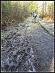
not see a lot of people going to the falls. The route has many ups and
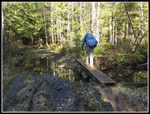
downs along the way. The biggest down was dropping to cross the NF
Wallace River on a big bridge. There was as good flow but much less
than I saw on a December trip last year. I wore my low top
non-waterproof light hiking shoes and my feet stayed dry all day. That
also mean that the falls had good flow but much less than in December.
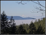
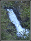
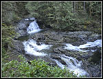
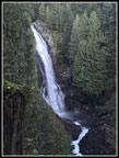
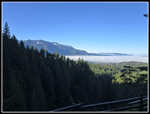
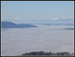
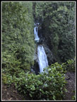
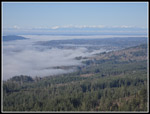
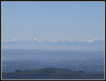
After the bridge a steep climb brought us up to the big picnic shelter. There was a group there. We dropped down and climbed back up to get views and photos of several falls. We could also see up the river to the big Middle Falls. It was looking good. The trail continues to climb to views of the Middle Falls and finally the Upper Falls. There is also a big of a view out to the valley below. The wooden viewpoint at the Upper Wallace Falls has been raised since my last visit. From the Upper Falls we followed the sometimes faint trail up to the road above. Once on the road we turned right and went over to the someone new bridge over the river and atop the Upper Falls. Then it was time to head for Wallace Lake. We had only covered 2.5 miles so far but much of the day's elevation gain. The road starts in forest then enters a clearcut. A short detour goes over to another viewpoint. We could see fog below in the valley and some snow on the north side of the ridge across from us. The Olympic Mountains were in the clear farther southwest. Even the towers of downtown Seattle and A bit of Bellevue were visible.
The road walk over to Wallace Lake was quite cold in the shade and much warmer when we were in sunshine. So far I saw one blooming yellow violet. I only added one blooming dandelion later on. The road comes to a "T" junction. We headed right. The gravel logging road soon turns right and the old dirt road to the lake continues straight ahead. Back in December the spot where a small creek crosses the road/trail was not mall. A hundred feet of the route was under water. I had walk on a narrow built up edge to stay dry. This time there was only water where the creek crosses the road and small bridge put in a few years ago allowed us to cross with dry feet. We then re-entered Wallace Falls State Park. We left it soon after reaching the road atop the falls. The forest is dark with lots of mossy ground cover as we neared the lake. We reached the bridge over the outlet at 10:30 am. We had covered 5.3 miles so far. That usually gets us at least half way on most hikes. We were still about 1.75 short of half way this time.
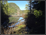
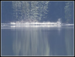
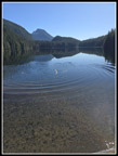
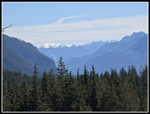
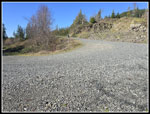
There were some logs down in December after a big storm. Today the entire route was in excellent condition. That is one benefit of hiking in a close to town state park. We took the trail around the lake. It is hard to see much of the lake from the road/trail. We were passed by a park truck on the way. In nearly 40 years visiting the lake I had never seen a vehicle up there. We could not tell how high the lake was. In December the inlet creek was roaring and Pebble Beach was under water. We hoped that would not be the case. When we reached the inlet creek it was dry. What is usually flat gravel in the channel with a couple tires fill of bigger rocks for stepping stones across was now a mound of gravel with only one tire visible. Everything was under the gravel pile. I was amazed how much was washed downstream and deposited here. There were only a couple small puddles in the creek bed. We popped out of the brush to find lots of dry ground at Pebble Beach. The sky was blue and we were completely in sunshine, as expected. We arrived at 10:47 and spent and hour there. There was as little breeze but a windshirt took care of that. We had lunch and just enjoyed the view and the sunshine. At the other end of the lake steam was rising and then a few minutes later it disappeared and then reappeared. The top of Mt. Index was visible and very snowy.
We were fortunate to spend that hour at the lake with total solitude. We packed up and headed back at 11:49 am. A couple minutes later a group passed us on the way to Pebble Beach. We hiked along the shore and took a detour into the clearcut. We hiked up to the highest point where we had a look down on part of Wallace Lake. There and at another nearby viewpoint we had great views from southeast to southwest. The fog that blanketed the valley earlier was now gone. We could see from Index and Persis to the Olympics and down the valley to the northwest. It was much warmer in the sunshine. We headed back to the lake and at the outlet found the group we saw earlier at the picnic table. We passed by and took the road/trail out the the main DNR Road. The forest was dark and cold. We popped out onto the road and back into some sunshine. A short way farther was the sign showing 5.9 miles to the trailhead via the DNR Road. Just after that we passed the top of the Greg Ball Trail. We chose to take the longer but sunnier road down. That also meant we would not see many people.
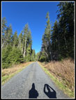
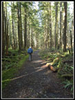
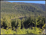
The road is moderately graded and smooth. We found we were going faster than we planned. We expected to keep up a 20 minute mile pace but it dropped to nearly 15 minutes at times. On my December trip, it was sunny but the sun was so low that I was in shade a lot. This time there was some shade in forest but in clearcuts the sun shined down on us. One biker passed us going up and again going down. It was not until the last mile of road that we saw some runners. We left the road and went back into forest again. The tread had a little water but much less than in December. My shoes remained dry all day. The trail met the Railroad Grade route at the 1.5 miles mark. We continued a good pace and that went by quickly. We did stop where the trail meets the powerline road. The view of Mts. Baring, Index, and Persis was now pretty clear. We reached the car at 3:02 pm. For the day we hiked 14.2 miles with 2100' of elevation gain. The lot was mostly full at the end of our day. The drive home turned out to be fine with only a short delay in Sultan and an easy detour around the Highway 522 closure. This was a long trip but with really good weather and trail conditions. It was nice to finish with so much sunshine.
Click on thumbnails to get
larger pictures.
Trips - 2026
Home
After the bridge a steep climb brought us up to the big picnic shelter. There was a group there. We dropped down and climbed back up to get views and photos of several falls. We could also see up the river to the big Middle Falls. It was looking good. The trail continues to climb to views of the Middle Falls and finally the Upper Falls. There is also a big of a view out to the valley below. The wooden viewpoint at the Upper Wallace Falls has been raised since my last visit. From the Upper Falls we followed the sometimes faint trail up to the road above. Once on the road we turned right and went over to the someone new bridge over the river and atop the Upper Falls. Then it was time to head for Wallace Lake. We had only covered 2.5 miles so far but much of the day's elevation gain. The road starts in forest then enters a clearcut. A short detour goes over to another viewpoint. We could see fog below in the valley and some snow on the north side of the ridge across from us. The Olympic Mountains were in the clear farther southwest. Even the towers of downtown Seattle and A bit of Bellevue were visible.
The road walk over to Wallace Lake was quite cold in the shade and much warmer when we were in sunshine. So far I saw one blooming yellow violet. I only added one blooming dandelion later on. The road comes to a "T" junction. We headed right. The gravel logging road soon turns right and the old dirt road to the lake continues straight ahead. Back in December the spot where a small creek crosses the road/trail was not mall. A hundred feet of the route was under water. I had walk on a narrow built up edge to stay dry. This time there was only water where the creek crosses the road and small bridge put in a few years ago allowed us to cross with dry feet. We then re-entered Wallace Falls State Park. We left it soon after reaching the road atop the falls. The forest is dark with lots of mossy ground cover as we neared the lake. We reached the bridge over the outlet at 10:30 am. We had covered 5.3 miles so far. That usually gets us at least half way on most hikes. We were still about 1.75 short of half way this time.
There were some logs down in December after a big storm. Today the entire route was in excellent condition. That is one benefit of hiking in a close to town state park. We took the trail around the lake. It is hard to see much of the lake from the road/trail. We were passed by a park truck on the way. In nearly 40 years visiting the lake I had never seen a vehicle up there. We could not tell how high the lake was. In December the inlet creek was roaring and Pebble Beach was under water. We hoped that would not be the case. When we reached the inlet creek it was dry. What is usually flat gravel in the channel with a couple tires fill of bigger rocks for stepping stones across was now a mound of gravel with only one tire visible. Everything was under the gravel pile. I was amazed how much was washed downstream and deposited here. There were only a couple small puddles in the creek bed. We popped out of the brush to find lots of dry ground at Pebble Beach. The sky was blue and we were completely in sunshine, as expected. We arrived at 10:47 and spent and hour there. There was as little breeze but a windshirt took care of that. We had lunch and just enjoyed the view and the sunshine. At the other end of the lake steam was rising and then a few minutes later it disappeared and then reappeared. The top of Mt. Index was visible and very snowy.
We were fortunate to spend that hour at the lake with total solitude. We packed up and headed back at 11:49 am. A couple minutes later a group passed us on the way to Pebble Beach. We hiked along the shore and took a detour into the clearcut. We hiked up to the highest point where we had a look down on part of Wallace Lake. There and at another nearby viewpoint we had great views from southeast to southwest. The fog that blanketed the valley earlier was now gone. We could see from Index and Persis to the Olympics and down the valley to the northwest. It was much warmer in the sunshine. We headed back to the lake and at the outlet found the group we saw earlier at the picnic table. We passed by and took the road/trail out the the main DNR Road. The forest was dark and cold. We popped out onto the road and back into some sunshine. A short way farther was the sign showing 5.9 miles to the trailhead via the DNR Road. Just after that we passed the top of the Greg Ball Trail. We chose to take the longer but sunnier road down. That also meant we would not see many people.
The road is moderately graded and smooth. We found we were going faster than we planned. We expected to keep up a 20 minute mile pace but it dropped to nearly 15 minutes at times. On my December trip, it was sunny but the sun was so low that I was in shade a lot. This time there was some shade in forest but in clearcuts the sun shined down on us. One biker passed us going up and again going down. It was not until the last mile of road that we saw some runners. We left the road and went back into forest again. The tread had a little water but much less than in December. My shoes remained dry all day. The trail met the Railroad Grade route at the 1.5 miles mark. We continued a good pace and that went by quickly. We did stop where the trail meets the powerline road. The view of Mts. Baring, Index, and Persis was now pretty clear. We reached the car at 3:02 pm. For the day we hiked 14.2 miles with 2100' of elevation gain. The lot was mostly full at the end of our day. The drive home turned out to be fine with only a short delay in Sultan and an easy detour around the Highway 522 closure. This was a long trip but with really good weather and trail conditions. It was nice to finish with so much sunshine.
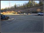 Parking Lot |
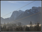 Mts Index & Persis |
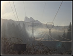 Hazy Baring Mountain |
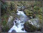 NF Wallace River |
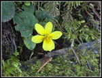 Yellow Violet |
 Fog From Viewpoint |
 Small Waterfall |
 Cascades |
 Middle Wallace Falls |
 Another Viewpoint |
 A Sea Of Fog |
 Upper Falls |
 Bridge Above Falls |
 Clearcut Viewpoint |
 Sunny Gravel Road |
 Frozen Ground |
 Bridge Into Park |
 Nearing Wallace Lake |
 Lake From Outlet |
 Steam On Lake |
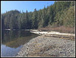 Pebble Beach |
 Looking Down Lake |
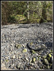 Rocky Inlet Creek |
 Wallace Lake Below |
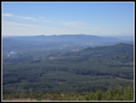 No Fog In Sky Valley |
 Mt. Hinman |
 Index & Hinman II |
 Hazy Olympic Mountains |
 Mt. Index |
 Leaving DNR Road |
 Back In Forest |
 Baring Mt. In The Clear |
Trips - 2026
Home