Before May 18th 1980 I had never been to Mount Saint Helens. I never camped at Spirit Lake. I never hiked the trails around the mountain. I certainly never thought about climbing it. After the eruption I began to get more and more interested in hiking. Several years later the mountain was opened back up to hiking on a limited basis. A
 maximum of 100 people per day would be allowed to venture above timberline.
The number would be restricted by the need to get a permit. I was intrigued
enough to apply for a permit as soon as they were offered. That first year
the thought of climbing up a mountain which so recently was blown apart was
very exciting. I submitted an application and received a permit
for late summer. At the time I couldn't have imagined that the climb would
become an annual event. Over the next 13 years I led parties of friends,
friends of friends, strangers, and an acquaintance or two up the mountain.
I missed one year and did it twice another. All totaled, I made 13 trips up
in 13 years. During those trips we encountered stifling heat, dense fog, and
about everything except hard rain. I guess I have become somewhat of an authority
on hiking the mountain. If you go here is a summary of what to expect.
maximum of 100 people per day would be allowed to venture above timberline.
The number would be restricted by the need to get a permit. I was intrigued
enough to apply for a permit as soon as they were offered. That first year
the thought of climbing up a mountain which so recently was blown apart was
very exciting. I submitted an application and received a permit
for late summer. At the time I couldn't have imagined that the climb would
become an annual event. Over the next 13 years I led parties of friends,
friends of friends, strangers, and an acquaintance or two up the mountain.
I missed one year and did it twice another. All totaled, I made 13 trips up
in 13 years. During those trips we encountered stifling heat, dense fog, and
about everything except hard rain. I guess I have become somewhat of an authority
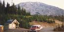
on hiking the mountain. If you go here is a summary of what to expect. The first thing to know is that the trailhead at the Climbers Bivouac is a long ways from Seattle. From my house in North Seattle it comes to exactly 200 miles one way. That's farther than driving to Portland. I have always gone down the night before the climb. If it's a Saturday climb then we go down after work and usually arrive after dark.
 If the next day will be hot we leave very early. Getting caught on the
south face of the mountain with no shade is brutal. It's much better to
get up early and shiver in the cold morning air. The parking lot is usually
full. I have had to drive around in the dark looking for any place to park
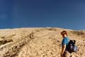
and put down sleeping bags. When we do get going, the trail starts out very
nicely. The trail is well maintained as it winds through the forest. As
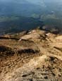
you near Monitor Ridge there are huge boulders near the trail. The way Becomes
steeper and intersects the round the mountain trail. Soon after that the
trail exits the forest and comes out in a flat rocky area near the base of
the ridge. Beyond this point one must have a permit. Formal trail ends and
the world of rock and sandy ash begins. The first step is to attain the top
of Monitor ridge on your left. Their are posts marking the route but I don't
think I have every taken the same route twice. Now that you are above the
trees the views begin and the shade ends.
If the next day will be hot we leave very early. Getting caught on the
south face of the mountain with no shade is brutal. It's much better to
get up early and shiver in the cold morning air. The parking lot is usually
full. I have had to drive around in the dark looking for any place to park
and put down sleeping bags. When we do get going, the trail starts out very
nicely. The trail is well maintained as it winds through the forest. As
you near Monitor Ridge there are huge boulders near the trail. The way Becomes
steeper and intersects the round the mountain trail. Soon after that the
trail exits the forest and comes out in a flat rocky area near the base of
the ridge. Beyond this point one must have a permit. Formal trail ends and
the world of rock and sandy ash begins. The first step is to attain the top
of Monitor ridge on your left. Their are posts marking the route but I don't
think I have every taken the same route twice. Now that you are above the
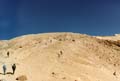
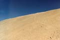
trees the views begin and the shade ends. The route from Monitor ridge on up is a combination of rocks and sand. At times you will take two steps up and slide one step down. Near the top this gets even worse. If it is past mid-summer of most years you may not encounter any snow at all. In early summer there will be snow but by staying well up on the ridge it is possible to make it
 most of the way up encountering very little of it. With out snow you
can expect a steep grinding descent. With the proper conditions you can
glissade most of the way down to the lower trail. The trail portion represents
about half the distance but only a fraction of the elevation gain. There
are several places where it is necessary to scramble up through large boulder
fields. This is a part I really enjoy. The rocks can be very sharp. It's
a good idea to have gloves when going through here. I have cut myself on
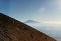
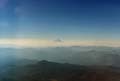
the rocks many times. On a clear day Mount Adams and Mount Hood loom to
the east and southeast. On one cloudy day we broke through into the sun
at about 7000' and only Adams and Hook were visible, like two islands in
the sea of clouds.
most of the way up encountering very little of it. With out snow you
can expect a steep grinding descent. With the proper conditions you can
glissade most of the way down to the lower trail. The trail portion represents
about half the distance but only a fraction of the elevation gain. There
are several places where it is necessary to scramble up through large boulder
fields. This is a part I really enjoy. The rocks can be very sharp. It's
a good idea to have gloves when going through here. I have cut myself on
the rocks many times. On a clear day Mount Adams and Mount Hood loom to
the east and southeast. On one cloudy day we broke through into the sun
at about 7000' and only Adams and Hook were visible, like two islands in
the sea of clouds. Once you are past the last of the rocks the summit is clearly visible up one last sandy slope. The frustrating thing is that while you can see people sitting on the crater rim (unless you are the first ones up) that last 1000 feet may take 30 minutes to an hour more. If you are caught in the midday sun you may not make it at all. Now the slip and
 slide fun begins. With snow you have fairly solid steps to follow. Without
it, two steps up can lead ot 1 1/2 steps down. It's like being on sand dunes
at the coast only you are over 7000' up a mountain. All you can do is slowly
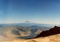
grind out the last of the elevation. When you do arrive at the top Mount
Rainier bursts into view to the north. Spirit Lake is below to the north.
Most impressive is the crater and the lava dome straight down below. If there
is still a cornice on the edge it's harder to see down. By late summer it's
easy to look straight down. If the wind is howling like it often does, the
dust can sand blast you enough to suggested dropping down to avoid it. A
short drop will often be enough to avoid the wind. If you left early and
have reached the top before noon you have lots of time to enjoy the summit.
I'm sure I have taken at least 100 photos from the top over the years. After
a nice long break it's time to head on down.
slide fun begins. With snow you have fairly solid steps to follow. Without
it, two steps up can lead ot 1 1/2 steps down. It's like being on sand dunes
at the coast only you are over 7000' up a mountain. All you can do is slowly
grind out the last of the elevation. When you do arrive at the top Mount
Rainier bursts into view to the north. Spirit Lake is below to the north.
Most impressive is the crater and the lava dome straight down below. If there
is still a cornice on the edge it's harder to see down. By late summer it's
easy to look straight down. If the wind is howling like it often does, the
dust can sand blast you enough to suggested dropping down to avoid it. A
short drop will often be enough to avoid the wind. If you left early and
have reached the top before noon you have lots of time to enjoy the summit.
I'm sure I have taken at least 100 photos from the top over the years. After
a nice long break it's time to head on down. The first steep section coming down is my favorite. When there is snow you can glissade the first 1000' in a few minutes. What may have taken an hour to climb you may be able to slide down in less than 10 minutes. When there is no snow I love to run down this stretch. Each step covers what seems like 10 feet as I run down the mountain. The soft sandy ash takes much of the pounding away from my knees. I have run down that 1000' in less than 8 minutes while watching hikers slowly moving up the mountain. The rest of the way down the ridge is either a fun slide on the snow or a knee pounding descent through the rock and ash. On a really hot day all I can think of is getting back to the trees and finding a little shade. Once off Monitor Ridge the last forest walk is an enjoyable way to finish up a great trip. Best of all, when you get back
 to the cars it's only another four hours to drive back to Seattle.
 If you have the time I recommend stopping at the Ape Cave on the way back. It is only a short detour from the road back. Bring a flashlight or lantern. The cave is interesting in it's own right and it is very cool. On a hot day the temperature can go from 90 to 50 just dropping down into the cave. I have explored some of the cave but would still like to go back to see more in the future.
Another idea is to explore the north side of the mountain. On two occasions I have done the summit on one day and the north side on the next. After summiting we drove around the east side of the mountain, camping in a makeshift spot off a logging road. The next morning, we drove over to the Norway Pass trailhead. The first time I tried this in the mid 80s the devastation was unbelievable. When I hiked up to Norway Pass there was no vegetation above my knees. It could have passed for the face of the moon. The last time I went, in the mid 90s there was much more vegetation. It's starting to look like it's alive once again. The most amazing thing I saw the first time was hillsides of trees knocked down like dominos. Not a branch was left. There was also a distinct line where the devastation ended. Miles of downed trees then suddenly healthy
 green trees. A line of separation ran right up a hillside. I'm glad I
have photos to look back on as much has changed in the 22 years since the
eruption. From Norway Pass you can look down on Spirit Lake. When I was last
there the north end of the lake was still covered with floating logs. The
lake is hundreds of feet higher now than before the eruption. Beyond Norway
Pass the trail continues to Mount Margaret. A short scramble from the trail
takes you to the top. This is a great place to view the aftermath of that
day back in May of 1980.
green trees. A line of separation ran right up a hillside. I'm glad I
have photos to look back on as much has changed in the 22 years since the
eruption. From Norway Pass you can look down on Spirit Lake. When I was last
there the north end of the lake was still covered with floating logs. The
lake is hundreds of feet higher now than before the eruption. Beyond Norway
Pass the trail continues to Mount Margaret. A short scramble from the trail
takes you to the top. This is a great place to view the aftermath of that
day back in May of 1980. That concludes my report on Mount Saint Hellions. It is "only" an 8 mile hike with about 4500' of elevation gain. After the snow is gone anyone with enough conditioning and will power can climb it. It's been about 4 years since I last went up. Somehow I expect I'll get back up there before much longer.
Near the top
|
Mount Rainier
|
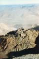
Lava Dome
|
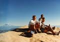
Bob, Val, and Bill
|
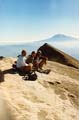
Bob, Val, and me
|

Bob, Val, and me
|
Everyone survived
|
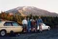
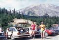
Before the hike
|
Home Photos Page 2