7-26-28-03
The Glacier Peak area has some
of the most spectacular backpacking country available. In all my years of
hiking I had never done more than day trips here. Several trips were changed
at the last minute due to weather. When Gary recommended a 3 day hike I
was more than ready to go. Ten years ago we day hiked up Pilot Ridge and
had some terrific views. This time we would hike Pilot and continue around
to White Pass and head out the North Fork Sauk River. We hoped that a Saturday
to Monday trip would minimize the crowds. Saturday morning we were at the
2200' trailhead by 9:00 and had to squeeze into a parking space. There was
a little more than a dozen cars parked. The morning was already warm with
much more heat forecast for the rest of the trip. The forecast was correct.
It was very hot by Sunday. The first 1 3/4 miles goes very fast. This section
is noted for the largest skunk cabbage leaves I have ever seen. They didn't
seem as large as I remembered but some were more than 3' long. Last time
we had to ford the river coming and going. It was deep enough then to be
difficult. A recent trip report mentioned a big log and we hoped to find
it. At the crossing a small way trail goes up stream to the log. It is plenty
large enough to safely cross on. We scrambled down stream again and picked
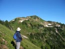
up the trail. The Pilot Ridge trail climbs at a steady grade in forest to
the ridge top. It's not a trail of endless gentle switchbacks but it is a
consistent grade as it switchbacks up the ridge. We planned a counterclockwise
loop so we would have a north facing wooded slope while we gained the
bulk of the elevation. Three miles and 3000' later we crested the ridge.
There was one creek in the forest below the ridge with good water flow. This
is the last easy water for many miles.
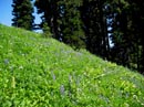
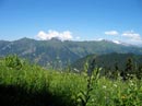
We had lunch with great views of the Monte Cristo peaks and Sloan Peak. We were now out in the sun and it was very hot. For the next 4 miles the trail is mostly on the ridge top. Sometimes on the north side and more often on the south. The entire hillside is lush green meadows much of the way. Many dozens of flower varieties are still in bloom. Some of the lupine and paintbrush combinations were outstanding. Did I mention bugs? They became much worse on the ridge top. While we kept moving they were only quite annoying. When we stopped they descended on us in hordes. Gary wore long pants the whole trip but I could not manage it with the heat. I just kept swatting and walking. The great part about hiking is that the pain of a few hundred bites is fading but my memories of the scenery will live on for years. We had hoped to camp on the ridge top instead of pushing on to Blue Lakes. As we neared Johnson Mountain we headed up to the ridge top and found a small tarn. With this water supply we were set. When the last of the snow melts this will no longer work. It was 8 1/2 miles with 4500' gained to our camp. Glacier Peak was across the valley from us. The sky was clear except for a few clouds just around Glacier. There was just enough breeze to allow us to remain outside our tents with the flies and mosquitos. I was tired from our exertions but Gary wanted to try for Johnson Mountain after dinner and I agreed. We didn't leave until 6:45 and we took headlamps. There were still a few small snowfields on the trail but the snow was soft and no trouble to cross. To this point we had seen one single woman backpacker all day. At the intersection of the trails to Blue Lakes and Johnson Mountain we saw a tent. We did not see the owner. Gary also saw two helium balloons high above the trail. We took the Johnson Mountain trail and climbed on up with steadily expanding views. We saw one small patch of paintbrush that was a color I have never seen before. It was somewhere between yellow and orange. Continuing on, we soon reached the summit. We camped at 6100' and Johnson Mountain is at 6721'. As the sun was setting the views were spectacular. We could see Blue Lakes just below us and mountains in all directions. Stuart, Daniel, Lemah, the Monte Cristos, Sloan, Bedal, Three Fingers, Glacier, White, and many more. At 8:10 we reluctantly headed down. On the descent Gary saw the balloons below us and we scrambled down and retrieved them. For the next day Gary had them tied to his pack. It was entertaining to see the looks on the faces of the few people we ran into. One couple didn't even seem to notice. We managed to get back just before dark. Surprisingly, our tents and packs were soaked by a very early dew. This was my first trip with my new Henry Shires Tarptent and even with the dew it performed very well. At just under 2 pounds it was a major factor in getting my pack weight down to 28 pounds.
I got up at 5:00 am to take sunrise photos of Glacier Peak. A little later a small herd of deer came by. It was nice to see one go right by my tent. We were up, packed, and on the way by 8:10 am. The trail contours towards Johnson and drops a little. It then climbs to a ridge top and drops down to Blue Lakes. The main trail goes by Little Blue Lake and climbs the ridge before turning and heading for Dishpan Gap and the Pacific Crest Trail. Another less used trail goes to Blue Lake, climbs straight up the ridge and drops down to meet the other trail. It has 200' more elevation gain but cuts out 2 1/2 miles. We opted for short and steep. We could see the route from Johnson Mountain the night before and so we knew it was snow free. We met a couple coming down just before the lake and another couple at the lake. How they were able to stand around with bare arms and legs with all the bugs was a mystery to me. The climb up to the ridge was short and steep. We went between several snowfields but had only a short easy section with snow. The trail was fine even with a backpack. At the top we had great views to the east and south. After the climb up Pilot Ridge we were almost entirely out in the open. This meant great views but nowhere to escape the heat. I am not very good in hot afternoon heat and this was as difficult as the elevation gain or the bugs. A quick steep descent and we met up with the Bald Eagle trail which is the route the trail to Little Blue Lake would take. Shortly thereafter we met the crest trail at Dishpan Gap. Dropping from the gap we found a fast flowing creek where we replenished our water supply. Later in the season water will be a bigger concern but we took no chances on finding more soon.
From here the trail winds around to the head of Meander Meadows. We saw one party far below in the valley. As we rounded Kodak Peak we left the trail and headed to the ridge. There was a way trail along the ridge to the top of Kodak. We brought along day packs and they proved very useful. On Johnson, Kodak, and White Mountains it was a relief to drop the backpack and put on the day pack. It was only about 350' to the top of Kodak. In keeping with this weekend we saw nobody. The view of Indian Head Peak and the other peaks to the south of Glacier Peak were fantastic. The Poets Ridge was close by and Mt. David was easy to spot. I have done David the last two years. It was one of the few times I have seen it from another peak. We were able to see many miles of the crest trail from the summit. A few hikers inched by far below us. We could also see White Mountain, above White Pass, our destination this day. At 2:10 we headed on down. One patch of trees on the ridge provided the first shade I had seen in many hours. It was tough to head back out into the sun. We dropped cross country back to the crest trail and continued north. We met a hiker at a stream crossing. He recommended we fill up here as there were no more water stops until Red Pass. We made a point of counting the ones we later saw. There were 8 clear flowing creeks by just beyond White Pass. Oh well.... We took his advice and pumped our water bottles full. I will fondly remember this place as the "hell hole of the crest". At least a dozen flies were on me at any given time. I had half a liter bottle full when a big fly flew right into it. A few curses later Gary dumped it out and we started again. Chinese water torture could not be worse than this was. With 2 liters of water and about a pint less blood we high tailed it out of there.
The trail descended to Indian Pass, the low point of the day, at 4950'. There were a few trees just before the pass and much needed shade. From the pass the trail begins a slow steady climb. It contours around Indian Head Peak and follows the east side of the ridge. The meadows were nothing short of glorious as we had spectacular mountain views and acres of wildflowers. This section seemed to go on and on forever. Each time we rounded a corner we could see 1/4 mile down the trail with no end in sight. Finally we reached White Pass around 4:30. We dropped 100' down to the camping area and found we were the only ones there. Since it was Sunday evening we had solitude that would have been very unlikely on Saturday. There was a creek a short way from our site with plenty of running water. We could see White Mountain looming 1200' directly above us. Originally we contemplated climbing it on Sunday evening but the reality of the heat and the bugs left me with far less vigor than I would have needed. Instead we escape the bugs after dinner in our tents.
The next morning we woke early to tackle White Mountain. It was forecast to reach 90 degrees in Seattle and we wanted to get out before the afternoon heat set in. From White Pass it is about 1/2 mile and 1100' to the summit. There is a way trail all the way to the top. It is steep in places but not technically difficult. A few hundred feet below the ridge Gary noticed a deer on the ridge top. Two more followed. They were up at 7000' in the early morning. I guess maybe we weren't up so early. We reached the top at 6:50 after a 40 minute climb. There is no better time to be on a mountain top than the early morning. The lighting was excellent and we each took many photos. For the first time Baker and Shuksan were in view. El Dorado was just above the ridge of Glacier Peak. We could look down on many places we would like to hike to some day. Rainier was clear as well. In fact, there was not a single. cloud in the sky. At first the wind was blowing hard and I actually had to put on clothing to stay warm. After all the heat it was a welcome feeling. We spent nearly 2 hours on top marveling at the unmatched views. This was among the best summits I have ever been on. Even the Olympics were visible in the distance. The 7040' summit of White was the high point of our journey. We reluctantly descended back to White Pass. I flushed a male and female grouse here and they kindly posed for photos. Even at 9:00 am it was getting hot. We put our backpacks back on and headed down. The North Fork Sauk trail is a nice walk with open switchbacks at first then deep forest. It was a bit of a let down compared to the rest of the trip. About half way down we reached Red Creek and a good source of water. The creek is nearly as big as the Sauk River at this point. The old crossing log is broken off and another downward sloping one is there. It is fine for now but not anchored well. Hopefully the forest service will see fit to put a new bridge or log here. It was deep and swift enough that I would not have wanted to ford. After 9 miles of slogging we finally reached the car and the long awaited air conditioning in Gary's car.
This was by far the best backpacking trip I have taken in the last decade. The weather, while overly hot, was at least clear. The flowers were phenomenal. The mountain views were extraordinary. I should stop here as I'm running out of superlatives. The totals were 31 miles with 9600' gained.
Click on thumbnails to get larger pictures.
Photo Page 2
Home
We had lunch with great views of the Monte Cristo peaks and Sloan Peak. We were now out in the sun and it was very hot. For the next 4 miles the trail is mostly on the ridge top. Sometimes on the north side and more often on the south. The entire hillside is lush green meadows much of the way. Many dozens of flower varieties are still in bloom. Some of the lupine and paintbrush combinations were outstanding. Did I mention bugs? They became much worse on the ridge top. While we kept moving they were only quite annoying. When we stopped they descended on us in hordes. Gary wore long pants the whole trip but I could not manage it with the heat. I just kept swatting and walking. The great part about hiking is that the pain of a few hundred bites is fading but my memories of the scenery will live on for years. We had hoped to camp on the ridge top instead of pushing on to Blue Lakes. As we neared Johnson Mountain we headed up to the ridge top and found a small tarn. With this water supply we were set. When the last of the snow melts this will no longer work. It was 8 1/2 miles with 4500' gained to our camp. Glacier Peak was across the valley from us. The sky was clear except for a few clouds just around Glacier. There was just enough breeze to allow us to remain outside our tents with the flies and mosquitos. I was tired from our exertions but Gary wanted to try for Johnson Mountain after dinner and I agreed. We didn't leave until 6:45 and we took headlamps. There were still a few small snowfields on the trail but the snow was soft and no trouble to cross. To this point we had seen one single woman backpacker all day. At the intersection of the trails to Blue Lakes and Johnson Mountain we saw a tent. We did not see the owner. Gary also saw two helium balloons high above the trail. We took the Johnson Mountain trail and climbed on up with steadily expanding views. We saw one small patch of paintbrush that was a color I have never seen before. It was somewhere between yellow and orange. Continuing on, we soon reached the summit. We camped at 6100' and Johnson Mountain is at 6721'. As the sun was setting the views were spectacular. We could see Blue Lakes just below us and mountains in all directions. Stuart, Daniel, Lemah, the Monte Cristos, Sloan, Bedal, Three Fingers, Glacier, White, and many more. At 8:10 we reluctantly headed down. On the descent Gary saw the balloons below us and we scrambled down and retrieved them. For the next day Gary had them tied to his pack. It was entertaining to see the looks on the faces of the few people we ran into. One couple didn't even seem to notice. We managed to get back just before dark. Surprisingly, our tents and packs were soaked by a very early dew. This was my first trip with my new Henry Shires Tarptent and even with the dew it performed very well. At just under 2 pounds it was a major factor in getting my pack weight down to 28 pounds.
I got up at 5:00 am to take sunrise photos of Glacier Peak. A little later a small herd of deer came by. It was nice to see one go right by my tent. We were up, packed, and on the way by 8:10 am. The trail contours towards Johnson and drops a little. It then climbs to a ridge top and drops down to Blue Lakes. The main trail goes by Little Blue Lake and climbs the ridge before turning and heading for Dishpan Gap and the Pacific Crest Trail. Another less used trail goes to Blue Lake, climbs straight up the ridge and drops down to meet the other trail. It has 200' more elevation gain but cuts out 2 1/2 miles. We opted for short and steep. We could see the route from Johnson Mountain the night before and so we knew it was snow free. We met a couple coming down just before the lake and another couple at the lake. How they were able to stand around with bare arms and legs with all the bugs was a mystery to me. The climb up to the ridge was short and steep. We went between several snowfields but had only a short easy section with snow. The trail was fine even with a backpack. At the top we had great views to the east and south. After the climb up Pilot Ridge we were almost entirely out in the open. This meant great views but nowhere to escape the heat. I am not very good in hot afternoon heat and this was as difficult as the elevation gain or the bugs. A quick steep descent and we met up with the Bald Eagle trail which is the route the trail to Little Blue Lake would take. Shortly thereafter we met the crest trail at Dishpan Gap. Dropping from the gap we found a fast flowing creek where we replenished our water supply. Later in the season water will be a bigger concern but we took no chances on finding more soon.
From here the trail winds around to the head of Meander Meadows. We saw one party far below in the valley. As we rounded Kodak Peak we left the trail and headed to the ridge. There was a way trail along the ridge to the top of Kodak. We brought along day packs and they proved very useful. On Johnson, Kodak, and White Mountains it was a relief to drop the backpack and put on the day pack. It was only about 350' to the top of Kodak. In keeping with this weekend we saw nobody. The view of Indian Head Peak and the other peaks to the south of Glacier Peak were fantastic. The Poets Ridge was close by and Mt. David was easy to spot. I have done David the last two years. It was one of the few times I have seen it from another peak. We were able to see many miles of the crest trail from the summit. A few hikers inched by far below us. We could also see White Mountain, above White Pass, our destination this day. At 2:10 we headed on down. One patch of trees on the ridge provided the first shade I had seen in many hours. It was tough to head back out into the sun. We dropped cross country back to the crest trail and continued north. We met a hiker at a stream crossing. He recommended we fill up here as there were no more water stops until Red Pass. We made a point of counting the ones we later saw. There were 8 clear flowing creeks by just beyond White Pass. Oh well.... We took his advice and pumped our water bottles full. I will fondly remember this place as the "hell hole of the crest". At least a dozen flies were on me at any given time. I had half a liter bottle full when a big fly flew right into it. A few curses later Gary dumped it out and we started again. Chinese water torture could not be worse than this was. With 2 liters of water and about a pint less blood we high tailed it out of there.
The trail descended to Indian Pass, the low point of the day, at 4950'. There were a few trees just before the pass and much needed shade. From the pass the trail begins a slow steady climb. It contours around Indian Head Peak and follows the east side of the ridge. The meadows were nothing short of glorious as we had spectacular mountain views and acres of wildflowers. This section seemed to go on and on forever. Each time we rounded a corner we could see 1/4 mile down the trail with no end in sight. Finally we reached White Pass around 4:30. We dropped 100' down to the camping area and found we were the only ones there. Since it was Sunday evening we had solitude that would have been very unlikely on Saturday. There was a creek a short way from our site with plenty of running water. We could see White Mountain looming 1200' directly above us. Originally we contemplated climbing it on Sunday evening but the reality of the heat and the bugs left me with far less vigor than I would have needed. Instead we escape the bugs after dinner in our tents.
The next morning we woke early to tackle White Mountain. It was forecast to reach 90 degrees in Seattle and we wanted to get out before the afternoon heat set in. From White Pass it is about 1/2 mile and 1100' to the summit. There is a way trail all the way to the top. It is steep in places but not technically difficult. A few hundred feet below the ridge Gary noticed a deer on the ridge top. Two more followed. They were up at 7000' in the early morning. I guess maybe we weren't up so early. We reached the top at 6:50 after a 40 minute climb. There is no better time to be on a mountain top than the early morning. The lighting was excellent and we each took many photos. For the first time Baker and Shuksan were in view. El Dorado was just above the ridge of Glacier Peak. We could look down on many places we would like to hike to some day. Rainier was clear as well. In fact, there was not a single. cloud in the sky. At first the wind was blowing hard and I actually had to put on clothing to stay warm. After all the heat it was a welcome feeling. We spent nearly 2 hours on top marveling at the unmatched views. This was among the best summits I have ever been on. Even the Olympics were visible in the distance. The 7040' summit of White was the high point of our journey. We reluctantly descended back to White Pass. I flushed a male and female grouse here and they kindly posed for photos. Even at 9:00 am it was getting hot. We put our backpacks back on and headed down. The North Fork Sauk trail is a nice walk with open switchbacks at first then deep forest. It was a bit of a let down compared to the rest of the trip. About half way down we reached Red Creek and a good source of water. The creek is nearly as big as the Sauk River at this point. The old crossing log is broken off and another downward sloping one is there. It is fine for now but not anchored well. Hopefully the forest service will see fit to put a new bridge or log here. It was deep and swift enough that I would not have wanted to ford. After 9 miles of slogging we finally reached the car and the long awaited air conditioning in Gary's car.
This was by far the best backpacking trip I have taken in the last decade. The weather, while overly hot, was at least clear. The flowers were phenomenal. The mountain views were extraordinary. I should stop here as I'm running out of superlatives. The totals were 31 miles with 9600' gained.
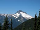
Sloan Peak |
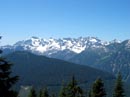
Monte Cristo Peaks |
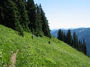
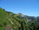
Pilot Ridge |
Pilot Ridge |
Portal Pk & White Mt |
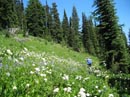
Flowers |
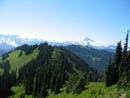
Pilot Ridge |
Johnson Mountain |
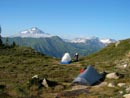
Camp Site |
Johnson Mountain |
Photo Page 2
Home