6-10-06
Gary was free and we wanted to get in a snow scramble.
We were leaning towards Ruth Mountain at Mt. Rainier. Neither of us had
been up it. The weather forecast looked great at mid week but worsened each
day. By Friday it was looking like we might be in clouds and some rain.
With that in mind we chose Goat Island which I had done before. I was confident
I could get up and down even if we had little visibility. I had scrambled
it
once
and Gary had never done it. I also had to be back in town in time to
provide a ride home from Sea-Tac airport.
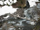
I drove to Kent and met Gary at 6:30 and he drove to the White River entrance at Mt. Rainier. We had overcast and some rain on the drive but it was dry as we parked at the Fryingpan Creek trailhead. There were a few snow patches at the trailhead but it was mostly bare. The trail began bare and soon was covered in patchy snow. We quickly met up with the Wonderland Trail. While the trail was near the creek it was mostly bare. A little way away from the creek and it was completely snow covered. Bare dirt gave way to several feet of snow in a short distance.
The waterfall overlook was impressive as the creek was running strong. One large tree is down across the trail but we had no trouble getting over it. A smaller tree was down but was even less of a problem. Most creek crossings are bridged and the others we could rock hop or cross on short logs. As we broke out into the open the overcast began to break. A small patch of blue began to grow. It was suddenly time for sun screen.
The log bridge crossing of Fryingpan Creek was snow free. There is still some snow on both sides. Across the creek the route heads straight up leaving the summer trail. We were following footprints in the well compacted snow. We crossed a few creeks on snow bridges. The snow is thinning fast but we made it across with no problems. From here the route is up the snow covered moraine. We stayed left of the main Fryingpan Creek until well up the valley. Up there the snow covered the creek almost entirely.
We were walking parallel to the ridge of Goat Island Mountain. The ridge makes a sharp left hand turn and runs along the end of the valley we were ascending. The grade soon steepened as we climbed up to a forested saddle. The route itself goes to the left of dense forest and remains on open slopes. I was sweating a lot as we climbed up in the bright sunshine. From the saddle we could now see down to the Emmons Glacier and across to Steamboat Prow and Mt. Ruth. The summit of Rainier was in the clouds but most else was in the clear.
Looking back we could see Summerland (more like Winterland). Panhandle Gap has a seriously large cornice. The trailhead is at 3600'. The summit is 7288'. The saddle is about 6400'. The climb up the ridge is not at all technical. Just one foot in front of the other. We had to weave through a few short bands of trees but mostly it's in the open. We reached Point 7218 at about noon and I was out of gas. We stopped for food and water.
In just a few minutes the sky changed dramatically. Even when we had blue sky we saw clouds all around us. Now they were back. Visibility went from several miles to 20'. Thankfully route finding amounts to staying on the ridge top. Much of the ridge above the saddle was on bare dirt. From the false summit we had a choice of snow on the spine of the ridge or rocks to the right. I stayed on rock longer than I should have. The snow was easier. A little light rain necessitated a jacket but it was still not very cold.
Up and over yet another high point and the ridge turned left for the final section to the summit. At one point we could actually see the summit through the clouds. The next high point did not prove to be the real top. It was just a short distance farther. Finally we reached the top. Views were almost non existent. At least the rain did not last long. There was also very little wind. Views would open and close in each direction.
The area around Sunrise opened up and Gary picked out the Sunrise Lodge. The parking lot appeared to be plowed. A few other peek-a-boo views occurred. With thoughts of getting to the airport on time in the back of my mind, and the lack of views, our summit stay was fairly short. We dropped off the summit, followed the ridge back to the right, and low and behold the clouds began to part. Suddenly Little Tahoma and Summerland reappeared. Soon we could see out towards Mt. Ruth. Gary picked out several hikers on the final snowfield below the summit of Ruth.
We proceeded over the false summit and other bumps and the sky continued to clear. The clearing was just over our area but clear it was. Gary saw a lone hiker with a long trail of footprints behind nearing the top of Meany Crest. Soon we saw a much larger group following the track but far below. After three hikers early on the only others we saw were miles away.
We dropped down to the saddle. Instead of following our tracks on an angling descent, we traversed across the slope. First we put on rain pants and exchanged poles for ice axes. The next 400 vertical feet were lost on our rears. The snow was a little soft but we were able to glissade much of the way back into the basin. As we recrossed the basin Gary spotted a tent in an area of small trees. We also crossed the many tracks of the large group we spotted above. There had been no fresh tracks in the morning but now there were footprints and some ski tracks.
The hike out was just a long snow slog with some dirt nearer the bottom. As we reached the bridge over Fryingpan Creek the rain began again as dark clouds covered the sky. We had light rain much of the way out but felt little of it once in the forest. We covered the last 4 miles in 1:10 allowing me to get back to Seattle in time to hear that the flight was delayed 2 hours. A lot of rushing for nothing.
This is the perfect time of year to scramble up Goat Island Mountain. The snow is well consolidated. The upper creek is easily crossed on fairly solid snow. There is no technically difficult sections though most of the trip is off trail. If the day is clear the ridge ramble has excellent views. We had every type of weather but between the light rain and dense clouds we had some great views. How often can you hike the Wonderland Trail towards Summerland and pass three people all day?
Click on thumbnails to get larger pictures.
Photo Page 2
Trips - 2006
Home
I drove to Kent and met Gary at 6:30 and he drove to the White River entrance at Mt. Rainier. We had overcast and some rain on the drive but it was dry as we parked at the Fryingpan Creek trailhead. There were a few snow patches at the trailhead but it was mostly bare. The trail began bare and soon was covered in patchy snow. We quickly met up with the Wonderland Trail. While the trail was near the creek it was mostly bare. A little way away from the creek and it was completely snow covered. Bare dirt gave way to several feet of snow in a short distance.
The waterfall overlook was impressive as the creek was running strong. One large tree is down across the trail but we had no trouble getting over it. A smaller tree was down but was even less of a problem. Most creek crossings are bridged and the others we could rock hop or cross on short logs. As we broke out into the open the overcast began to break. A small patch of blue began to grow. It was suddenly time for sun screen.
The log bridge crossing of Fryingpan Creek was snow free. There is still some snow on both sides. Across the creek the route heads straight up leaving the summer trail. We were following footprints in the well compacted snow. We crossed a few creeks on snow bridges. The snow is thinning fast but we made it across with no problems. From here the route is up the snow covered moraine. We stayed left of the main Fryingpan Creek until well up the valley. Up there the snow covered the creek almost entirely.
We were walking parallel to the ridge of Goat Island Mountain. The ridge makes a sharp left hand turn and runs along the end of the valley we were ascending. The grade soon steepened as we climbed up to a forested saddle. The route itself goes to the left of dense forest and remains on open slopes. I was sweating a lot as we climbed up in the bright sunshine. From the saddle we could now see down to the Emmons Glacier and across to Steamboat Prow and Mt. Ruth. The summit of Rainier was in the clouds but most else was in the clear.
Looking back we could see Summerland (more like Winterland). Panhandle Gap has a seriously large cornice. The trailhead is at 3600'. The summit is 7288'. The saddle is about 6400'. The climb up the ridge is not at all technical. Just one foot in front of the other. We had to weave through a few short bands of trees but mostly it's in the open. We reached Point 7218 at about noon and I was out of gas. We stopped for food and water.
In just a few minutes the sky changed dramatically. Even when we had blue sky we saw clouds all around us. Now they were back. Visibility went from several miles to 20'. Thankfully route finding amounts to staying on the ridge top. Much of the ridge above the saddle was on bare dirt. From the false summit we had a choice of snow on the spine of the ridge or rocks to the right. I stayed on rock longer than I should have. The snow was easier. A little light rain necessitated a jacket but it was still not very cold.
Up and over yet another high point and the ridge turned left for the final section to the summit. At one point we could actually see the summit through the clouds. The next high point did not prove to be the real top. It was just a short distance farther. Finally we reached the top. Views were almost non existent. At least the rain did not last long. There was also very little wind. Views would open and close in each direction.
The area around Sunrise opened up and Gary picked out the Sunrise Lodge. The parking lot appeared to be plowed. A few other peek-a-boo views occurred. With thoughts of getting to the airport on time in the back of my mind, and the lack of views, our summit stay was fairly short. We dropped off the summit, followed the ridge back to the right, and low and behold the clouds began to part. Suddenly Little Tahoma and Summerland reappeared. Soon we could see out towards Mt. Ruth. Gary picked out several hikers on the final snowfield below the summit of Ruth.
We proceeded over the false summit and other bumps and the sky continued to clear. The clearing was just over our area but clear it was. Gary saw a lone hiker with a long trail of footprints behind nearing the top of Meany Crest. Soon we saw a much larger group following the track but far below. After three hikers early on the only others we saw were miles away.
We dropped down to the saddle. Instead of following our tracks on an angling descent, we traversed across the slope. First we put on rain pants and exchanged poles for ice axes. The next 400 vertical feet were lost on our rears. The snow was a little soft but we were able to glissade much of the way back into the basin. As we recrossed the basin Gary spotted a tent in an area of small trees. We also crossed the many tracks of the large group we spotted above. There had been no fresh tracks in the morning but now there were footprints and some ski tracks.
The hike out was just a long snow slog with some dirt nearer the bottom. As we reached the bridge over Fryingpan Creek the rain began again as dark clouds covered the sky. We had light rain much of the way out but felt little of it once in the forest. We covered the last 4 miles in 1:10 allowing me to get back to Seattle in time to hear that the flight was delayed 2 hours. A lot of rushing for nothing.
This is the perfect time of year to scramble up Goat Island Mountain. The snow is well consolidated. The upper creek is easily crossed on fairly solid snow. There is no technically difficult sections though most of the trip is off trail. If the day is clear the ridge ramble has excellent views. We had every type of weather but between the light rain and dense clouds we had some great views. How often can you hike the Wonderland Trail towards Summerland and pass three people all day?
| Click on photo at right then "Next" to see 12 photos. More photos coming soon! |
Bridge |
|||
Photo Page 2
Trips - 2006
Home