4-30-11
Time
for another snow scramble. Sun and moderately high avalanche danger.
Time to head east again to a fairly safe climb. I first hiked up Yellow
Hill in September 1990. I continued on to Elbow Peak too. In January
2003 I did a winter scramble with the Mountaineers. Cloudy with few
views that day. We returned at dark. I was ready for a third visit in
21 years to see the snowy views I missed on the last trip. The Middle
Fork Teanaway Road is plowed to within 2 1/4 miles of the start of the
Yellow Hill Trail. That adds 4 1/2 miles of flat road walking in
winter. I hoped we would be able to drive farther this day.
I met Janet in Bellevue and we headed east. This was my third trip in as many weeks to the Teanaway area. We headed up the NF Teanaway Road and turned onto the West Fork Road then almost immediately right onto the Middle Fork Teanaway Road. At the end of pavement there was no snow so we kept on going. In a little less than half a mile snow began. A big patch followed by dirt and then more snow. Two high clearance trucks drove through. We got out to take a look. The first patch looked okay with the Subaru so we plowed ahead. The third patch was the worst. Hard and icy with tracks that might have been deep enough to high center my car. I straddled the tracks and made it across. Now the road was bard and we made it to the Middle Fork bridge and trailhead.
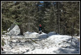
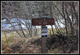
The road narrowed and turned uphill and I did not want to risk deeper snow and no way to turn around. We parked, packed our gear, and headed out. A short way ahead the road has slumped. A short drop then a very steep climb back to road level. Zero chance a regular car could get by here. In only a third of a mile we reached the turn for the Yellow Hill route. The trailhead was way up this road back in 1990. Now there is a trailhead sign at the junction.
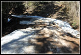
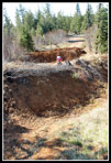
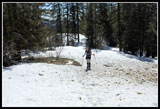
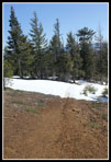
We walked the road a short way and came to a couple industrial strength berms and trenches. Must be 15 feet from top to bottom. Not too difficult to hike up and down and up and down to get past them. The real surprise is that we parked at 2700' and were now at 3300' with still no snow on the route. Patchy snow began and in shady spots there were long snow patches. Still, we had some dirt most of the way to the end of the road.
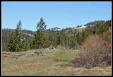
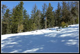
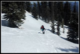
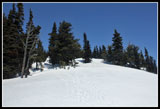
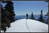
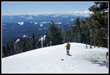
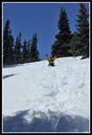
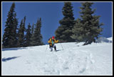
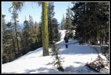
From the road end we climbed up to the ridge top. Most of the way was on snow with some dirt showing through. There were some old footprints that were indistinct. The snow was still not very deep here. The trail follows on or to the left of the ridge all the way up to the summit. We stopped for a break at the first high point. Some peaks were visible to the north but not the main Teanaway peaks. The route drops slightly to several saddles before climbing again. Total drops added up to about 250'. We followed the trail as it traversed a steep hillside. Here microspikes were helpful but not essential. The snow was much softer and easier on the way back.
That was the only even partly exposed spot on the trip. The snow became deeper above 4000' and softer as the day progressed. Now earlier footprints became much more obvious. On some steep sections they were 6-8 inches deep. We climbed to a flat spot on the ridge and the summit could finally be seen through the trees. One more short drop and the final 700' of climbing to the top. This part was steep in places but the softening snow made for deep footprints. Too deep near the top. The last 100' vertical feet was not much fun. I was sinking mid thigh on some steps and hardly at all on others. It seemed to take forever to get the last short bit.
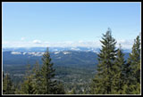
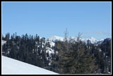
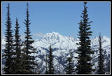
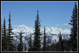
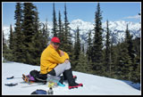
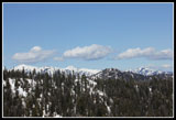
Finally we topped out on a nice open viewpoint and walked the last short distance to a point that is maybe 5 feet higher. The real high point is not very distinct. After no views on my previous winter visit I was pleasantly surprised to be able to see most all the Teanaway peaks and the Stuart Range. It was already 1:00 pm when we arrived and the sun washed out the colors but a very nice view none the less. The summit is forested but there are enough openings to see most peaks to the north. It was only in the low forties and a jacket was in order. The bright sun made it feel much warmer.
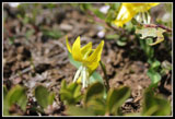
After lunch we had the much easier job of getting back down. Sinking mid thigh deep was not so bad downhill. The first 100' of descent must have taken 10 minutes less than the ascent. If the snow was just a little firmer a good glissade could have been had. We chopped 1 1/2 hours off our time coming up on the way down. By the time we reached the road it was feeling very warm. On the drive in we saw many glacier lilies along the MF Teanaway Road. Once parked we had a few miles of bare ground hiking the road and saw not a one. Coming down I was looking all over for at least one glacier lily. That is exactly what I found. Down below the road I found a single patch of half a dozen glacier lilies. Hopefully Janet's photos turned out better than mine.
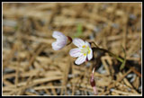
We did see a lot of spring beauty and some other small flowers along the road. Spring is late but it finally showing some signs of arriving. Once back at the car the only concern was getting back across the snow patches on the road. The first one had melted out somewhat and required a narrow straddle but we made it across. The others were no problem. Construction had part of I-90 down to one lane. I hoped the delay would not be too bad. Continuing our good luck on the day we sailed right on through at the reduced speed limit.
This was a fine spring scramble. The GPS recorded 8.17 miles round trip with 3300' of elevation gain. On the road/trail we saw exactly zero people. The last three weekends I have seen exactly one person on three hikes and he was a friend. Not a single unknown hiker in three weeks. Who says there is not much solitude to be found? Great weather, great company, and a fun summit scramble made for a great day to be in the mountains.
Click on thumbnails to get
larger pictures.
Trips - 2011
Home
I met Janet in Bellevue and we headed east. This was my third trip in as many weeks to the Teanaway area. We headed up the NF Teanaway Road and turned onto the West Fork Road then almost immediately right onto the Middle Fork Teanaway Road. At the end of pavement there was no snow so we kept on going. In a little less than half a mile snow began. A big patch followed by dirt and then more snow. Two high clearance trucks drove through. We got out to take a look. The first patch looked okay with the Subaru so we plowed ahead. The third patch was the worst. Hard and icy with tracks that might have been deep enough to high center my car. I straddled the tracks and made it across. Now the road was bard and we made it to the Middle Fork bridge and trailhead.
The road narrowed and turned uphill and I did not want to risk deeper snow and no way to turn around. We parked, packed our gear, and headed out. A short way ahead the road has slumped. A short drop then a very steep climb back to road level. Zero chance a regular car could get by here. In only a third of a mile we reached the turn for the Yellow Hill route. The trailhead was way up this road back in 1990. Now there is a trailhead sign at the junction.
We walked the road a short way and came to a couple industrial strength berms and trenches. Must be 15 feet from top to bottom. Not too difficult to hike up and down and up and down to get past them. The real surprise is that we parked at 2700' and were now at 3300' with still no snow on the route. Patchy snow began and in shady spots there were long snow patches. Still, we had some dirt most of the way to the end of the road.
From the road end we climbed up to the ridge top. Most of the way was on snow with some dirt showing through. There were some old footprints that were indistinct. The snow was still not very deep here. The trail follows on or to the left of the ridge all the way up to the summit. We stopped for a break at the first high point. Some peaks were visible to the north but not the main Teanaway peaks. The route drops slightly to several saddles before climbing again. Total drops added up to about 250'. We followed the trail as it traversed a steep hillside. Here microspikes were helpful but not essential. The snow was much softer and easier on the way back.
That was the only even partly exposed spot on the trip. The snow became deeper above 4000' and softer as the day progressed. Now earlier footprints became much more obvious. On some steep sections they were 6-8 inches deep. We climbed to a flat spot on the ridge and the summit could finally be seen through the trees. One more short drop and the final 700' of climbing to the top. This part was steep in places but the softening snow made for deep footprints. Too deep near the top. The last 100' vertical feet was not much fun. I was sinking mid thigh on some steps and hardly at all on others. It seemed to take forever to get the last short bit.
Finally we topped out on a nice open viewpoint and walked the last short distance to a point that is maybe 5 feet higher. The real high point is not very distinct. After no views on my previous winter visit I was pleasantly surprised to be able to see most all the Teanaway peaks and the Stuart Range. It was already 1:00 pm when we arrived and the sun washed out the colors but a very nice view none the less. The summit is forested but there are enough openings to see most peaks to the north. It was only in the low forties and a jacket was in order. The bright sun made it feel much warmer.
After lunch we had the much easier job of getting back down. Sinking mid thigh deep was not so bad downhill. The first 100' of descent must have taken 10 minutes less than the ascent. If the snow was just a little firmer a good glissade could have been had. We chopped 1 1/2 hours off our time coming up on the way down. By the time we reached the road it was feeling very warm. On the drive in we saw many glacier lilies along the MF Teanaway Road. Once parked we had a few miles of bare ground hiking the road and saw not a one. Coming down I was looking all over for at least one glacier lily. That is exactly what I found. Down below the road I found a single patch of half a dozen glacier lilies. Hopefully Janet's photos turned out better than mine.
We did see a lot of spring beauty and some other small flowers along the road. Spring is late but it finally showing some signs of arriving. Once back at the car the only concern was getting back across the snow patches on the road. The first one had melted out somewhat and required a narrow straddle but we made it across. The others were no problem. Construction had part of I-90 down to one lane. I hoped the delay would not be too bad. Continuing our good luck on the day we sailed right on through at the reduced speed limit.
This was a fine spring scramble. The GPS recorded 8.17 miles round trip with 3300' of elevation gain. On the road/trail we saw exactly zero people. The last three weekends I have seen exactly one person on three hikes and he was a friend. Not a single unknown hiker in three weeks. Who says there is not much solitude to be found? Great weather, great company, and a fun summit scramble made for a great day to be in the mountains.
 Slump In Road |
 Huge Trench |
 Early Wildflowers |
 Snow Above |
 View Out |
 Ascending To Ridge |
 Hiking On Ridge |
 Teanaway Peaks |
 Deeper Snow |
 Climbing To Summit |
 Nearing Summit |
 Mt. Stuart From Summit |
 Stuart Range |
 Yellow On Yellow Hill |
 More Summit Views |
 Heading Down |
 Slow Glissade |
 Post Holing |
 Clouds & Peaks |
 Ridge Roaming |
 Some Bare Trail |
 Glacier Lily |
 Poser |
 Trail Sign |
Trips - 2011
Home