9-13-14
Mt.
David is one of my favorite hikes. Since 2001 I've done it six times
now. All but the first have trip reports. One in 2002,
2004,
2008,
2010
and now this one. In early June I presented at the Washington Trails
Association's "Hike The State". I had the Glacier Peak Wilderness and I
talked about Mt. David as my "difficult hike". It is that. Over 14
miles round trip with 5700' of elevation gain. On the plus side the
trail is not overly steep. It also has one of the best high ridge
walks. The summit is great but the views begin long before the top. I
was curious if my talk had more than the usual had full of groups on
the trail.
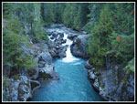
Gary has joined me for the last five trips. This day we met in Bothell at 5:15 am and headed east on Highway 2. Though it is still summer for another week we started out in the dark and returned in the dark. We turned north to Lake Wenatchee then west up the White River Road to the trailhead at the end. The small parking lot was mostly full at 7:20 am. For the first time in a long time it was cold at the start. Only one party signed in for Mt. David the previous weekend. We were the first this day. We crossed the bridge over the White River and turned left, heading downstream. The first mile is downhill and does not help in warming up. We made very good time.
There is a reason all my trips have been in September. The days are getting shorter but the heat is gone. The bugs are gone. The snow that lingers late on the north side of the ridge below the summit is gone. I'll take the cold morning. The Panther Creek Trail has really deteriorated in the 13 years since my first visit. The start has really become overgrown. After the junction we finally began to climb. The next 3.5 miles gains 3200'. The trail switchbacks many times as it gains elevation. We took a break for short sleeves and shorts. The morning cold was forgotten. At our break spot I noticed an insulator and wire for communications to the old fire lookout on the summit. A lone woman passed us by as she made very good time heading up David.
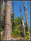
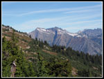
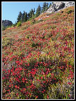
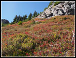
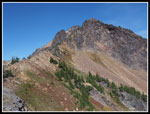
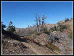
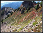
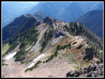
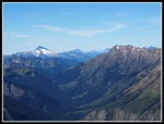
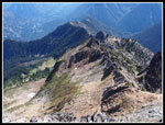
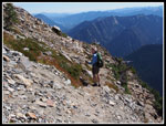
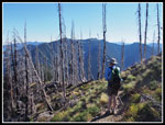
There are a number of logs down on the trail. We counted an even 60. Only half a dozen are a problem. Even those just slowed us down a little. All can be gotten under, over, or around. Most are just step overs. On our last trip we reached the ridge top in 1:57. This time with the logs and an easier pace we took about 2:17. After a break we headed on at 10:00 am. The route goes along one side of the ridge then the other and even along the crest. As we rose Mt. Daniel came into view to the south. Clark Mountain is to the northwest. We could see up to Boulder Pass. The route enters a burn zone from a recent fire. The year after we found a lot of ash. Now there are a lot of silvered snags and still a little ash. Some fireweed is blooming and some has gone to seed. There are a number of the down logs in the burn.
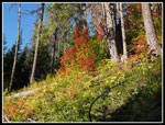
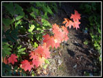
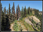
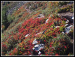
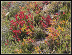
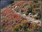
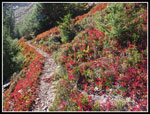
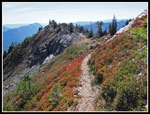
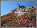
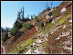
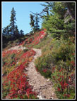
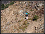
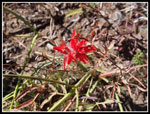
We started so see some fall color though it was not great at first. There was some color even well below the ridge. Some orange, a little red, and some green. High up it was mostly the low berry bushes. Drab in one direction but lit up when backlit by the sun. We passed below the big pika filled talus field and switchbacked up the other side. The leaf color improved. Some of the best color of the day was here. On the ridge we contoured to the right side and climbed again to the ridge. On the left side we entered the big gully. The trail is narrow here as it switchbacks back up to the ridge top. Now we just had to drop to the north side, contour along and climb back to the ridge top below the summit.
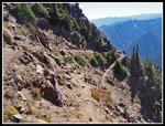
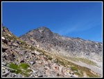
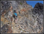
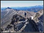
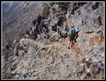
As we dropped down we met the long hiker on her way down. She was hiking David then heading up to meet some trail workers logging out the Indian Creek Trail. Okay. We started heading along the rocky trail and Gary came to a fast stop. Right off the trail was a ptarmigan. I seldom see these birds. They freeze when in danger. They blend in completely. This one did not seem to care about us. It just kept eating grass. A minute later we noticed a rock was moving. That was ptarmigan #2. Then we saw the third one. A most unexpected situation. The trail up to the ridge is in tough shape. It switchbacks up a rocky slope with a number of water cut washouts. It makes for poor footing. There is no exposure just bad tread. Up on the ridge at about 7200' we had great views. The last 250' are a bit scrambly. When the trail gets hard to see we headed straight up to find the ledge blasted out of rock that leads to the summit. It's airy but not too bad.
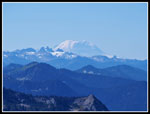
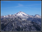
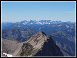
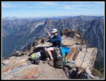
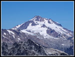
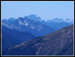
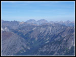
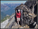
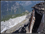
We reached the summit at 12:45 pm. Not even close to our fastest ascent but a very enjoyable trip along the ridge and lots of photo stops. The first view of Glacier Peak is at the summit. It's right in your face. From the 7420' summit the views are spectacular. From Mt. Stuart and Mt. Rainier to the south to Glacier Peak, Seven Fingered Jack, and Mt. Maude to the north. Sloan Peak and Three Fingers are to the west. A really great viewpoint. We were in no hurry. We had all day. In fact, we spent 1:20 on top. Of course, we had to make another visit to the stone outhouse. It blends with the rock very well. The drop off right by the door is dramatic. We added a few more photos and packed up to head down. At 2:05 pm we started down.
The blasted ledge has exposure. We took our time. The loose rock below was also slow. We dropped back to the ridge top and dropped down on the loose narrow trail with washouts. Finally after traversing a ways we were back on good tread. We climbed back to the ridge and started down the gully. We soon saw a party coming up. Three folks set to camp on the summit and a dog. We were very careful descending as rockfall could be deadly. We were glad to be out of the gully. The rest of the way along the ridge was great. Sunshine, a little breeze, fall color, and great views. The fun ended as we reached the point to leave the ridge. The trail down is well graded and easy on the knees even with 3200' to lose. It seemed to take a long time. We were glad to finally reach the bottom and start the gently climb along the river. At 6:20 we reached the bridge and the parking lot.
We stopped at the 59er Diner for dinner then headed home. It was 10:00 pm when I arrived home. From a 4:00 am alarm to 10:00 pm return it was a long day. Long but a whole lot of fun. This is not an every year trip but it is a very strenuous trip with a huge payoff that I will surely do again.
Click on thumbnails to get
larger pictures.
Trips - 2014
Home
Gary has joined me for the last five trips. This day we met in Bothell at 5:15 am and headed east on Highway 2. Though it is still summer for another week we started out in the dark and returned in the dark. We turned north to Lake Wenatchee then west up the White River Road to the trailhead at the end. The small parking lot was mostly full at 7:20 am. For the first time in a long time it was cold at the start. Only one party signed in for Mt. David the previous weekend. We were the first this day. We crossed the bridge over the White River and turned left, heading downstream. The first mile is downhill and does not help in warming up. We made very good time.
There is a reason all my trips have been in September. The days are getting shorter but the heat is gone. The bugs are gone. The snow that lingers late on the north side of the ridge below the summit is gone. I'll take the cold morning. The Panther Creek Trail has really deteriorated in the 13 years since my first visit. The start has really become overgrown. After the junction we finally began to climb. The next 3.5 miles gains 3200'. The trail switchbacks many times as it gains elevation. We took a break for short sleeves and shorts. The morning cold was forgotten. At our break spot I noticed an insulator and wire for communications to the old fire lookout on the summit. A lone woman passed us by as she made very good time heading up David.
There are a number of logs down on the trail. We counted an even 60. Only half a dozen are a problem. Even those just slowed us down a little. All can be gotten under, over, or around. Most are just step overs. On our last trip we reached the ridge top in 1:57. This time with the logs and an easier pace we took about 2:17. After a break we headed on at 10:00 am. The route goes along one side of the ridge then the other and even along the crest. As we rose Mt. Daniel came into view to the south. Clark Mountain is to the northwest. We could see up to Boulder Pass. The route enters a burn zone from a recent fire. The year after we found a lot of ash. Now there are a lot of silvered snags and still a little ash. Some fireweed is blooming and some has gone to seed. There are a number of the down logs in the burn.
We started so see some fall color though it was not great at first. There was some color even well below the ridge. Some orange, a little red, and some green. High up it was mostly the low berry bushes. Drab in one direction but lit up when backlit by the sun. We passed below the big pika filled talus field and switchbacked up the other side. The leaf color improved. Some of the best color of the day was here. On the ridge we contoured to the right side and climbed again to the ridge. On the left side we entered the big gully. The trail is narrow here as it switchbacks back up to the ridge top. Now we just had to drop to the north side, contour along and climb back to the ridge top below the summit.
As we dropped down we met the long hiker on her way down. She was hiking David then heading up to meet some trail workers logging out the Indian Creek Trail. Okay. We started heading along the rocky trail and Gary came to a fast stop. Right off the trail was a ptarmigan. I seldom see these birds. They freeze when in danger. They blend in completely. This one did not seem to care about us. It just kept eating grass. A minute later we noticed a rock was moving. That was ptarmigan #2. Then we saw the third one. A most unexpected situation. The trail up to the ridge is in tough shape. It switchbacks up a rocky slope with a number of water cut washouts. It makes for poor footing. There is no exposure just bad tread. Up on the ridge at about 7200' we had great views. The last 250' are a bit scrambly. When the trail gets hard to see we headed straight up to find the ledge blasted out of rock that leads to the summit. It's airy but not too bad.
We reached the summit at 12:45 pm. Not even close to our fastest ascent but a very enjoyable trip along the ridge and lots of photo stops. The first view of Glacier Peak is at the summit. It's right in your face. From the 7420' summit the views are spectacular. From Mt. Stuart and Mt. Rainier to the south to Glacier Peak, Seven Fingered Jack, and Mt. Maude to the north. Sloan Peak and Three Fingers are to the west. A really great viewpoint. We were in no hurry. We had all day. In fact, we spent 1:20 on top. Of course, we had to make another visit to the stone outhouse. It blends with the rock very well. The drop off right by the door is dramatic. We added a few more photos and packed up to head down. At 2:05 pm we started down.
The blasted ledge has exposure. We took our time. The loose rock below was also slow. We dropped back to the ridge top and dropped down on the loose narrow trail with washouts. Finally after traversing a ways we were back on good tread. We climbed back to the ridge and started down the gully. We soon saw a party coming up. Three folks set to camp on the summit and a dog. We were very careful descending as rockfall could be deadly. We were glad to be out of the gully. The rest of the way along the ridge was great. Sunshine, a little breeze, fall color, and great views. The fun ended as we reached the point to leave the ridge. The trail down is well graded and easy on the knees even with 3200' to lose. It seemed to take a long time. We were glad to finally reach the bottom and start the gently climb along the river. At 6:20 we reached the bridge and the parking lot.
We stopped at the 59er Diner for dinner then headed home. It was 10:00 pm when I arrived home. From a 4:00 am alarm to 10:00 pm return it was a long day. Long but a whole lot of fun. This is not an every year trip but it is a very strenuous trip with a huge payoff that I will surely do again.
 The White River |
 Insulator & Wire |
 Bright Color Down Low |
 Sun Shines On Leaves |
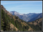 Views To The NW |
 On The Ridge Top |
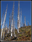 Silver Snags |
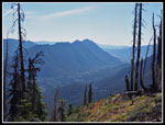 White River Valley |
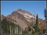 Mt. David In Sight |
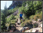 Gary On Trail |
 Clark Mt. In View |
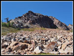 Boulder Field |
 Color Begins |
 More Color |
 Color = Slow Travel |
 Great Leaves, Few Berries |
 Climbing Higher |
 Very Nice Color |
 Trail To Nowhere |
 Snags On Ridge |
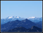 Mts. Daniel & Hinman |
 Mt. Rainier |
 More Fall Color |
 Red, White, & Blue |
 Switchbacking Higher |
 Gary & Color |
 Red Border |
 Entering Gully |
 Trail Below |
 Up The Gully |
 Three Ptarmigans |
 Beneath The Summit |
 Gary On Ledge |
 Glacier Peak |
 Sloan & Indian Head |
 Monte Cristo Peaks |
 Gary On Summit |
 Trail From Summit |
 Glacier Peak Again |
 Three Fingers |
 7 Fingered Jack, Maude |
 Heading To Loo |
 Me In The IgLoo |
 Long Way Down |
 Gary's Turn |
 Heading Down Ledge |
 Sketchy Trail |
 Back In Burn |
 Lone Indian Paintbrush |
Trips - 2014
Home