5/20-21/17
On
5-17-14
I hiked up Iron Peak
with Gwen. A snowy trip to the summit and back. I mentioned that I had
camped on the summit a number of times. Gwen wanted to do it. Fast
forward three years. For her birthday Gwen wanted to camp on the
summit. I had camped there five times but it had been six years since
my last time. Okay, I agreed to another summit camp. We headed out
Saturday morning. A stop in Cle Elum and we continued on to the NF
Teanaway Road and then the end of the Beverly Creek Road. The road is
now snow free. We arrived at 9:45 am and were on the trail at 10:08 am.
A later start than I ususally get but we were only going one way. The
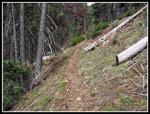
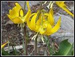
first road section has lots of trillium, yellow violets, and spring
beauty in bloom. This time of year most folks head up Bean Creek to ski
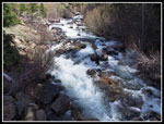
on Earl Peak. We took the Beverly Creek Trail and needed to cross Bean
Creek.
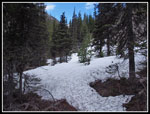
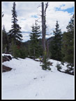
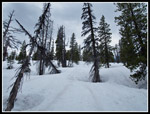
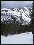
There are three channels of Bean Creek at the crossing. Usually two or three are running. This year the entire creek was in the middle channel. With spring snow melt that was a lot of water. We put on water crossing shoes to keep our boots dry so early in the hike. The water was swift but we had no problems getting across. The trail continued snow free farther on. Lots of glacier lilies and spring beauties in bloom here. There were four or five trees down across the trail this winter. None are hard to get over or around. Soon there was a little snow on the ground. At the boulder field there was more snow in the open. Back in forest it was bare trail a little longer. Before long snow returned and was mostly continuous everywhere above there.
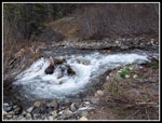
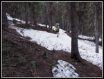
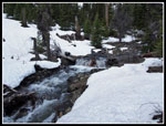
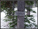
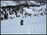
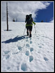
There were some tracks in the snow and they kept us exactly on the summer trail. The route leaves forest and drops down to the creek. We stopped for a break there. Lots of water in Beverly Creek. The snow was not very thick in the lower basin. Just 3-7 inches or so with a few bare spots. This will melt out in a few weeks. Footprints in the snow took us near the creek but avoided most of the down trees. A pretty good route. Higher up in the basin we met a group that had scrambled Bill Peak and was already coming down. They too carried snowshoes. We asked if they used them and the answer was "no". Maybe we would not use them either. Much to my surprise we found the "Fourth Creek" trail sign and the one at the junction with the Beverly Creek Trail. We followed the route to near the summer creek crossing. In the upper basin the snow was now 4-6 feet deep. All the better to find a solid snow bridge. It won't last much longer but the crossing spot we found was good enough to get us across.
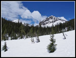
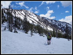
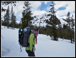
The snow conditions were good. We sank in 3-5 inches with each step but it was consistent with no post holing. I expected to reach the ridge top at the saddle between Iron and Teanaway Peaks. We headed in that general direction. The climb form the creek is in forest at first. Widely dispersed trees allowing an easy ascent around them. I feared we would be in bright sunshine for this climb but the forecast had it wrong. Instead of mostly sunny it was largely overcast. Warm but without the direct sunshine. That was fine with us. Occasionally the sun would shine through and it would instantly get hot. The combination of a number of stops, lots of photos, and the steady climb with a winter weight backpack kept our pace slow. We had all day so it really did not matter.
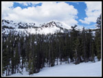
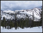
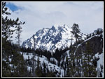
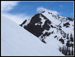
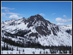
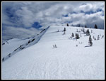
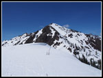
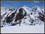
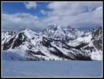
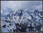
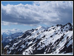
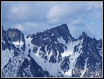
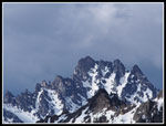
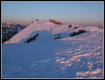
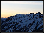
As we climbed, Bill Peak come into the open. Soon after, we could look behind us to Volcanic Neck, Bean, Navaho, Earl, Mary, and Judi Peaks. They looked terrific with a coat of winter snow. Higher up Mt. Stuart made an appearance over Beverly - Turnpike Pass. That is one striking mountain. As we reached a point where the slopes of the Iron Peak ridge were in sight we could pick out boot and ski tracks. Someone had ascended via my often used route right near the summit. That is a 400' climb straight up between two cornices. Much of the ridge is cornices. That point and the saddle are usually the safest places to go up. On the day trip Gwen and I did in 2014 we went up the long steep slope near the summit then came down a shorter slope south of the saddle. That was looking pretty good this day. No cornices left and about half the climb of the route near the summit.
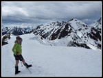
There was a set of boot tracks up there too. That was where we went up. It looked pretty steep most of the way then a short very steep spot at the top. I took out an ice axe. Most of the way up was fine. Nice snow for kicking steps. The top did prove to be interesting. The short very steep spot had loose snow. The prior boot steps broke out. I kick more and use the axe to pull myself up. Gwen followed me up to the ridge. Now we had all the views to the west. Hawkins, and Esmerelda, and many more peaks. It was 2:50 pm on the ridge top. About five hours up. We still had more than six hours of daylight left. One steep climb on the ridge then some nice walking out towards the summit of Iron Peak. When we reached the spot where the steep climb route reaches the ridge we dropped our packs.
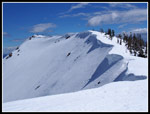
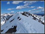
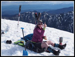
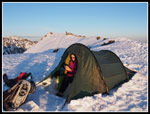
Right beyond the ridge narrows from 40' to several feet wide. A very steep drop on the left side and a slightly less steep drop on the right. Depending on snow conditions, this can be an easy walk or a bit of a rocky scramble. We crossed it and reached wide ridge top once again. A short walk took us to the summit. There were a couple spots with some bare rock. With all the snow I did not recognize the actual summit. We did not see the summit register. After a short stay we headed back to our packs. I usually camp between the summit and the narrow ridge spot. Our packs were at the most level spot and it was plenty wide. We chose to camp there. We knew that the east side of the ridge top was over a cornice so we kept well away from it.
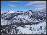
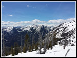
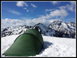
We leveled out a tent spot and raised the tent. As we finished a spitting of rainy sleet fell for a minute then stopped. That was it. My four season Nallo 3 provided plenty of room for two people. Our tent site was completely exposed from all sides so a rainfly that went all the way to the ground was essential. We oriented the tent with the front looking right at Mt. Stuart. Not a bad view from our weekend home. There was no shortage of snow so we melted water to rehydrate and prepare for dinner. The views from Iron Peak are among the best. It sits with clear views to the south, east, and west. All the Cascade Crest peaks were in sight. Only to the north do Stuart and Teanaway Peak block the view. Those peaks are not bad to look at either.
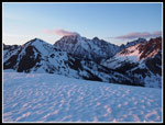
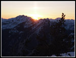
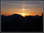
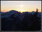
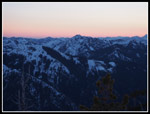
After dinner we retired to the tent for some rest. Since we arrived on top the sky had begun to clear. The chance of some good sunset colors improved. Some pink color began to show at about 8:30 pm. By 8:45 pm the sun was behind the mountains to the west. We did have a sun pillar. A vertical shaft of light rose above the setting sun. I was not familiar with this phenomenon but Gwen was. I'm never too old to learn new things. Unlike my February, March, and early April camps on Iron, now it was not dark until about 9:00 pm. Much better than diving into the tent at 6:00 pm for a very long night.
Click on thumbnails to get
larger pictures.
Day 2
Trips - 2017
Home
There are three channels of Bean Creek at the crossing. Usually two or three are running. This year the entire creek was in the middle channel. With spring snow melt that was a lot of water. We put on water crossing shoes to keep our boots dry so early in the hike. The water was swift but we had no problems getting across. The trail continued snow free farther on. Lots of glacier lilies and spring beauties in bloom here. There were four or five trees down across the trail this winter. None are hard to get over or around. Soon there was a little snow on the ground. At the boulder field there was more snow in the open. Back in forest it was bare trail a little longer. Before long snow returned and was mostly continuous everywhere above there.
There were some tracks in the snow and they kept us exactly on the summer trail. The route leaves forest and drops down to the creek. We stopped for a break there. Lots of water in Beverly Creek. The snow was not very thick in the lower basin. Just 3-7 inches or so with a few bare spots. This will melt out in a few weeks. Footprints in the snow took us near the creek but avoided most of the down trees. A pretty good route. Higher up in the basin we met a group that had scrambled Bill Peak and was already coming down. They too carried snowshoes. We asked if they used them and the answer was "no". Maybe we would not use them either. Much to my surprise we found the "Fourth Creek" trail sign and the one at the junction with the Beverly Creek Trail. We followed the route to near the summer creek crossing. In the upper basin the snow was now 4-6 feet deep. All the better to find a solid snow bridge. It won't last much longer but the crossing spot we found was good enough to get us across.
The snow conditions were good. We sank in 3-5 inches with each step but it was consistent with no post holing. I expected to reach the ridge top at the saddle between Iron and Teanaway Peaks. We headed in that general direction. The climb form the creek is in forest at first. Widely dispersed trees allowing an easy ascent around them. I feared we would be in bright sunshine for this climb but the forecast had it wrong. Instead of mostly sunny it was largely overcast. Warm but without the direct sunshine. That was fine with us. Occasionally the sun would shine through and it would instantly get hot. The combination of a number of stops, lots of photos, and the steady climb with a winter weight backpack kept our pace slow. We had all day so it really did not matter.
As we climbed, Bill Peak come into the open. Soon after, we could look behind us to Volcanic Neck, Bean, Navaho, Earl, Mary, and Judi Peaks. They looked terrific with a coat of winter snow. Higher up Mt. Stuart made an appearance over Beverly - Turnpike Pass. That is one striking mountain. As we reached a point where the slopes of the Iron Peak ridge were in sight we could pick out boot and ski tracks. Someone had ascended via my often used route right near the summit. That is a 400' climb straight up between two cornices. Much of the ridge is cornices. That point and the saddle are usually the safest places to go up. On the day trip Gwen and I did in 2014 we went up the long steep slope near the summit then came down a shorter slope south of the saddle. That was looking pretty good this day. No cornices left and about half the climb of the route near the summit.
There was a set of boot tracks up there too. That was where we went up. It looked pretty steep most of the way then a short very steep spot at the top. I took out an ice axe. Most of the way up was fine. Nice snow for kicking steps. The top did prove to be interesting. The short very steep spot had loose snow. The prior boot steps broke out. I kick more and use the axe to pull myself up. Gwen followed me up to the ridge. Now we had all the views to the west. Hawkins, and Esmerelda, and many more peaks. It was 2:50 pm on the ridge top. About five hours up. We still had more than six hours of daylight left. One steep climb on the ridge then some nice walking out towards the summit of Iron Peak. When we reached the spot where the steep climb route reaches the ridge we dropped our packs.
Right beyond the ridge narrows from 40' to several feet wide. A very steep drop on the left side and a slightly less steep drop on the right. Depending on snow conditions, this can be an easy walk or a bit of a rocky scramble. We crossed it and reached wide ridge top once again. A short walk took us to the summit. There were a couple spots with some bare rock. With all the snow I did not recognize the actual summit. We did not see the summit register. After a short stay we headed back to our packs. I usually camp between the summit and the narrow ridge spot. Our packs were at the most level spot and it was plenty wide. We chose to camp there. We knew that the east side of the ridge top was over a cornice so we kept well away from it.
We leveled out a tent spot and raised the tent. As we finished a spitting of rainy sleet fell for a minute then stopped. That was it. My four season Nallo 3 provided plenty of room for two people. Our tent site was completely exposed from all sides so a rainfly that went all the way to the ground was essential. We oriented the tent with the front looking right at Mt. Stuart. Not a bad view from our weekend home. There was no shortage of snow so we melted water to rehydrate and prepare for dinner. The views from Iron Peak are among the best. It sits with clear views to the south, east, and west. All the Cascade Crest peaks were in sight. Only to the north do Stuart and Teanaway Peak block the view. Those peaks are not bad to look at either.
After dinner we retired to the tent for some rest. Since we arrived on top the sky had begun to clear. The chance of some good sunset colors improved. Some pink color began to show at about 8:30 pm. By 8:45 pm the sun was behind the mountains to the west. We did have a sun pillar. A vertical shaft of light rose above the setting sun. I was not familiar with this phenomenon but Gwen was. I'm never too old to learn new things. Unlike my February, March, and early April camps on Iron, now it was not dark until about 9:00 pm. Much better than diving into the tent at 6:00 pm for a very long night.
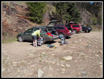 Parking Lot |
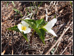 Trillium |
 Beverly Creek |
 Bean Creek |
 Still Snow Free |
 Snow At 4200' |
 Mostly On Snow |
 Beverly Creek Break |
 Glacier Lilies |
 Heading Up Valley |
 Bill Peak In Sight |
 Iron Peak Above |
 Under Mary Peak |
 Trail Junction |
 Heading Uphill |
 Fourth Creek Pass |
 Climbing Higher |
 Mt. Stuart View |
 Gwen & Teanaway Peak |
 Iron Peak Ridge |
 Last Climb To Ridge |
 Teanaway Peak |
 View East |
 Bill Peak |
 Gwen Nears Ridge |
 On Iron Ridge |
 Teanaway From Ridge |
 Gwen Climbs Higher |
 Ridge To Summit |
 Gwen Nears Campsite |
 View West |
 Narrow Ridge |
 View North |
 Gwen On Ridge |
 Tent Is Up |
 Stuart In Clouds |
 Everything Is Good |
 View Northwest |
 Little Annapurna |
 Dramatic Lighting |
 Gwen In Tent |
 Lighting Near Sunset |
 Almost Sunset |
 Last Light |
 Great Color |
 Nice Lighting |
 Lit Up To The East |
 More Sunset Color |
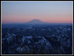 Mt. Rainier Sunset |
 More Sunset Color |
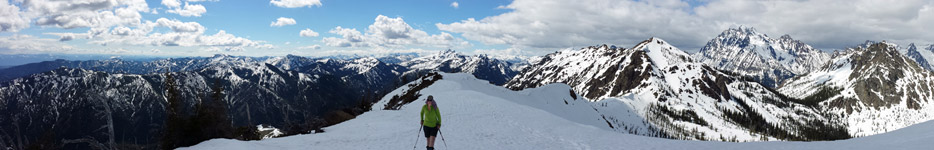 Panorama From The Summit Of Iron Peak |
Day 2
Trips - 2017
Home