04-26-25
Gary
was back from South America and was ready for a spring hike. We looked
east of the Cascades for desert wildflower colors. Unfortunately, for
the third consecutive weekend the winds were supposed to by high. Gusts
to 25-30 most everywhere. We went back and forth on taking a shot and
decided to plan for a west side trip and check on the winds in the
morning. At 6:00 am gust forecasts had not changed so we went for the
safer choice of a sunny but cooler day on the west side with little
wind and different types of wildflowers. We had both done Pine and
Cedar Lakes for the first and only time on 04-18-21.
It was just before the Covid vaccine was available. Gary, John, and I
all drove separately to that hike. We had a nice variety of wildflowers
on that trip. It was 4 years and 1 week earlier. We hiked to the lakes
than headed west for more miles and elevation gain. I logged that trip
as 11 miles with 3200' of gain. It was just what Gary needed after
several weeks with minimal elevation gain.
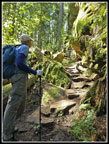
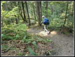
We met at Ash Way P&R in Lynnwood at 6:40 am and Gary drove us north. We arrived at the 300' trailhead just south of Bellingham at 7:46 am. We were on our way at 7:54 am. We well remembered that the trail starts as an old very steep logging road. It continues climbing for 1.7 miles to 1600'. That is steep for a road. The bleeding hearts started immediately. We would continue to see them on most of our route. Next came the trillium. White, then pink, and some almost red ones. As with other recent hikes, we saw some salmonberry flowers but not very many. They still have a week or two to be at prime. It was only 47F at the start so we did not overhead on the climb. We did warm up fast though. The road was a bit rocky near the start but was easy walking most of the way. At 1 mile we reached the shortcut. The old road goes straight up. A newer road with a couple switchbacks adds .20 miles but is much easier walking. In addition to the previously mentioned flowers, we began to see yellow violets. At 1.7 miles we met a junction with trails heading west. We would be using that route later. We continued ahead for a minute or so th another junction. Right drops to the lakes. Left climbs up to a viewpoint of Mt. Baker. We had only clouds and haze to the east on our drive up so we did not expect much of a Baker view. Nonetheless, he had to give it a try.
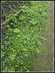
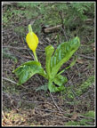
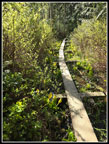
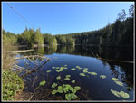
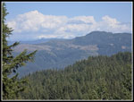
In .40 miles we reached the viewpoint. It was hazy but we could make out Mt. Baker and the Twin Sisters. It was a better view than we expected. The trail then begins to descend towards Cedar Lake. Near the lake the trail crosses over a big log. Steps have been cut in the lot to form a staircase. It was pretty neat. At the lake we immediately met a guy out fishing. The trail goes around the lake. We chose to take a left turn. The is on narrow boardwalks on parts of the trail at both lakes. It was not especially wet off the wooden walkway most of the time. Half way around the lake we met the other part of the around the lake trail. We continued on uphill to a "T" junction. Left went to Pine Lake. Right would later take us back to the 1.7 mile junction. We dropped to Pine Lake, arriving at 9:55 am. First we went right on another narrow boardwalk. It was lined with skunk cabbage. We saw a few at Cedar Lake but this display was much larger. At the end of the boardwalk a tent was at the campsite. We avoided the campers by dropping to a view from the shore. The view was pretty good. We could see the peninsula that would be our next objective.
We retraced our route back to the trail down and continued on along the shore. The trail took us to the peninsula. Last time we found a group of campers here. This time we were alone. We went out to the end of the short peninsula to take a food and water break. It was then 10:10 am. It was more like brunch than lunchtime. We were out of forest and in the sunshine. It felt much warmer out there. Our break lasted for 20 minutes. We heard a woodpecker in the snag right next to us. Gary found it right near the top. We took a few distant photos. It appeared to have white on a wing and a little red on its head. I did not notice the red until at home looking at my big monitor. Heading back, we saw two guys who had just arrived. They were there to go fishing. They had two big blow up inflated chairs for fishing in the lake. We headed back around the lake than uphill away from it. We passed the route from Cedar Lake and took the other trail which took us back to the junction at 1.7 miles.
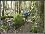
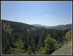
Now, we headed west on the Hemlock Trail. This forested trail brought us by some big sandstone rocks and vertical walls. At the next junction, we went left on the Raptor Ridge Trail. We did this loop in the opposite direction from our first visit. We took the short detour to the Raptor Ridge Viewpoint. Unfortunately, a big family was already there. We took a few photos and continued on. We had planned on a lunch break in the sunshine and now we were back in the forest. We continued along below the ridge top as the trail began to descend. We both had the idea to head uphill to the ridge top and hope to find a sunny spot. Off we went. Near the top it looked to be totally forested. I tried going a little to the right and there it was. An open spot with smaller trees all around it, a rock to sit on, and bright sunshine overhead. We were lucky to bumble into this spot. We arrived at 11:30 am and stayed until 12:25 pm. It did not seem like nearly an hour but it was really nice sitting in the sunshine with no bugs or wind.
All good things must come to an end and so did our lunch break. We dropped back to the trail and continued on. We passed the Huckleberry Trail junction and kept going. The trail goes around Chuckanut Mountain. On our first visit we hiked up the slope to the forested summit. This time we stayed on the trail. From there the trail switchbacked down to the Lost Lake Trail. I hiked the Lost Lake Trail the weekend before on my Lost Lake-Ridge Trail Loop trip. Today I would hike a short .50 mile section of the trail. We reached the Madrone Crest Trail and headed uphill to our right. Most of our trips are uphill in the morning and downhill later on. This one had a bunch of ups and downs. We were now 6.5 miles into our trip and heading uphill once again. We quickly reached a junction and headed right and uphill. This trail leads to the top of the ridge and what was once a viewpoint. Even in 2021 the view was mostly gone. We headed up anyway for some more mileage and elevation gain. We had seen some closed spring beauty earlier but now the flowers had opened for the day. Add one more flower seen. We reached the top just before another group caught up with us. We had not seen a lot of people on the trail but at two of three named viewpoints we saw others.
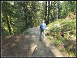
Our stay on top was short. We haded down to the junction and continued on the main trail. The trail seemed to be descending a lot more than we expected. We still had to climb back up to Raptor Ridge. The earlier favorites continued with more bleeding hearts, trillium, and spring beauty. We even saw some big bunches of small mushrooms. We met a junction with the Salal Trail and our route became the Salal Trail. The next junction was a big one. We could go right on a longer route up to the Raptor Ridge Trail or go left on the shorter Hemlock Trail. We chose left. The trail climbed gently then steeply up to the Raptor Ridge Tail. We turned left and soon reached the 1.7 mile junction for the third time. Rather then head down we chose to go up to the Mt. Baker viewpoint a second time. We arrived to find the view worse than in the morning. Now it was time to head down. We went back to the junction then down the last 1.7 miles to the trailhead. It was steep near the bottom but much less steep than we kept expecting. We arrived at the bottom at 4:01 pm. For the day we hiked just under 12 miles with 3100' of elevation gain.
This turned out to be a very nice hike. We managed to get in lots of mileage and elevation gain. We saw people but it was never very crowded on the trail. We found a great spot for solitude and sunshine at lunchtime. The wildflower varieties were a bit limited but we saw a lot of the ones in bloom. We did not have all the colors of the east side desert flowers show but we still have a month or so to enjoy that. For the day we had almost perfect weather for a west side wildflower hike.
Click on thumbnails to get
larger pictures.
Trips - 2025
Home
We met at Ash Way P&R in Lynnwood at 6:40 am and Gary drove us north. We arrived at the 300' trailhead just south of Bellingham at 7:46 am. We were on our way at 7:54 am. We well remembered that the trail starts as an old very steep logging road. It continues climbing for 1.7 miles to 1600'. That is steep for a road. The bleeding hearts started immediately. We would continue to see them on most of our route. Next came the trillium. White, then pink, and some almost red ones. As with other recent hikes, we saw some salmonberry flowers but not very many. They still have a week or two to be at prime. It was only 47F at the start so we did not overhead on the climb. We did warm up fast though. The road was a bit rocky near the start but was easy walking most of the way. At 1 mile we reached the shortcut. The old road goes straight up. A newer road with a couple switchbacks adds .20 miles but is much easier walking. In addition to the previously mentioned flowers, we began to see yellow violets. At 1.7 miles we met a junction with trails heading west. We would be using that route later. We continued ahead for a minute or so th another junction. Right drops to the lakes. Left climbs up to a viewpoint of Mt. Baker. We had only clouds and haze to the east on our drive up so we did not expect much of a Baker view. Nonetheless, he had to give it a try.
In .40 miles we reached the viewpoint. It was hazy but we could make out Mt. Baker and the Twin Sisters. It was a better view than we expected. The trail then begins to descend towards Cedar Lake. Near the lake the trail crosses over a big log. Steps have been cut in the lot to form a staircase. It was pretty neat. At the lake we immediately met a guy out fishing. The trail goes around the lake. We chose to take a left turn. The is on narrow boardwalks on parts of the trail at both lakes. It was not especially wet off the wooden walkway most of the time. Half way around the lake we met the other part of the around the lake trail. We continued on uphill to a "T" junction. Left went to Pine Lake. Right would later take us back to the 1.7 mile junction. We dropped to Pine Lake, arriving at 9:55 am. First we went right on another narrow boardwalk. It was lined with skunk cabbage. We saw a few at Cedar Lake but this display was much larger. At the end of the boardwalk a tent was at the campsite. We avoided the campers by dropping to a view from the shore. The view was pretty good. We could see the peninsula that would be our next objective.
We retraced our route back to the trail down and continued on along the shore. The trail took us to the peninsula. Last time we found a group of campers here. This time we were alone. We went out to the end of the short peninsula to take a food and water break. It was then 10:10 am. It was more like brunch than lunchtime. We were out of forest and in the sunshine. It felt much warmer out there. Our break lasted for 20 minutes. We heard a woodpecker in the snag right next to us. Gary found it right near the top. We took a few distant photos. It appeared to have white on a wing and a little red on its head. I did not notice the red until at home looking at my big monitor. Heading back, we saw two guys who had just arrived. They were there to go fishing. They had two big blow up inflated chairs for fishing in the lake. We headed back around the lake than uphill away from it. We passed the route from Cedar Lake and took the other trail which took us back to the junction at 1.7 miles.
Now, we headed west on the Hemlock Trail. This forested trail brought us by some big sandstone rocks and vertical walls. At the next junction, we went left on the Raptor Ridge Trail. We did this loop in the opposite direction from our first visit. We took the short detour to the Raptor Ridge Viewpoint. Unfortunately, a big family was already there. We took a few photos and continued on. We had planned on a lunch break in the sunshine and now we were back in the forest. We continued along below the ridge top as the trail began to descend. We both had the idea to head uphill to the ridge top and hope to find a sunny spot. Off we went. Near the top it looked to be totally forested. I tried going a little to the right and there it was. An open spot with smaller trees all around it, a rock to sit on, and bright sunshine overhead. We were lucky to bumble into this spot. We arrived at 11:30 am and stayed until 12:25 pm. It did not seem like nearly an hour but it was really nice sitting in the sunshine with no bugs or wind.
All good things must come to an end and so did our lunch break. We dropped back to the trail and continued on. We passed the Huckleberry Trail junction and kept going. The trail goes around Chuckanut Mountain. On our first visit we hiked up the slope to the forested summit. This time we stayed on the trail. From there the trail switchbacked down to the Lost Lake Trail. I hiked the Lost Lake Trail the weekend before on my Lost Lake-Ridge Trail Loop trip. Today I would hike a short .50 mile section of the trail. We reached the Madrone Crest Trail and headed uphill to our right. Most of our trips are uphill in the morning and downhill later on. This one had a bunch of ups and downs. We were now 6.5 miles into our trip and heading uphill once again. We quickly reached a junction and headed right and uphill. This trail leads to the top of the ridge and what was once a viewpoint. Even in 2021 the view was mostly gone. We headed up anyway for some more mileage and elevation gain. We had seen some closed spring beauty earlier but now the flowers had opened for the day. Add one more flower seen. We reached the top just before another group caught up with us. We had not seen a lot of people on the trail but at two of three named viewpoints we saw others.
Our stay on top was short. We haded down to the junction and continued on the main trail. The trail seemed to be descending a lot more than we expected. We still had to climb back up to Raptor Ridge. The earlier favorites continued with more bleeding hearts, trillium, and spring beauty. We even saw some big bunches of small mushrooms. We met a junction with the Salal Trail and our route became the Salal Trail. The next junction was a big one. We could go right on a longer route up to the Raptor Ridge Trail or go left on the shorter Hemlock Trail. We chose left. The trail climbed gently then steeply up to the Raptor Ridge Tail. We turned left and soon reached the 1.7 mile junction for the third time. Rather then head down we chose to go up to the Mt. Baker viewpoint a second time. We arrived to find the view worse than in the morning. Now it was time to head down. We went back to the junction then down the last 1.7 miles to the trailhead. It was steep near the bottom but much less steep than we kept expecting. We arrived at the bottom at 4:01 pm. For the day we hiked just under 12 miles with 3100' of elevation gain.
This turned out to be a very nice hike. We managed to get in lots of mileage and elevation gain. We saw people but it was never very crowded on the trail. We found a great spot for solitude and sunshine at lunchtime. The wildflower varieties were a bit limited but we saw a lot of the ones in bloom. We did not have all the colors of the east side desert flowers show but we still have a month or so to enjoy that. For the day we had almost perfect weather for a west side wildflower hike.
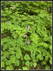 The First Bleeding Hearts |
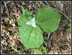 Big Leaves On Trillium |
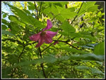 Salmonberry Flower |
 More Bleeding Hearts |
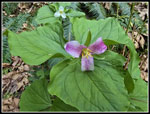 Pink Trillium |
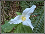 Perfect Trillium |
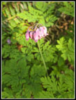
 Yellow Violets |
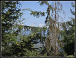
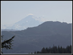 Hazy Mt. Baker |
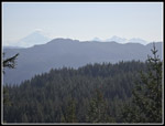 Hazy Twin Sisters |
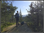 Gary At Viewpoint |
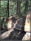 Log Steps |
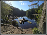 Cedar Lake |
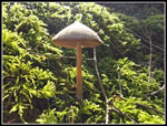
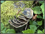
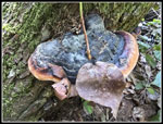 Shelf Fungus |
 First Skunk Cabbage |
 Skunk Cabbage Boardwalk |
 Nice Bog Lantern |
 Pine Lake |
 Backlit Skunk Cabbage |
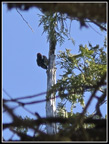 Woodpecker |
 Raptor Ridge |
 Mossy Rock |
 Raptor Ridge Viewpoint |
 Viewpoint View |
 A Mushroom |
 More Yellow Violets |
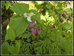 Trillium & Bleeding Hearts |
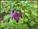 Nice Bleeding Hearts |
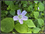 Spring Beauty |
 Madrone Crest View |
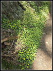
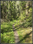 Narrow Trail |
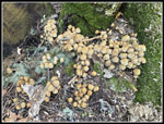 Many Mushrooms |
 Mt. Baker View Again |
 Gary At Wiggle |
 Colorful Fungus |
 Almost Done |
Trips - 2025
Home