11-14-09
I didn't have
time for a long drive so I settled on an old favorite. I had not been
up to the East Peak and back down in a decade. I have done a number of
one way trips from end to end on the Rattlesnake Mountain Trail but not
up and down from Rattlesnake Lake. I was surprised to find a number of
empty spaces in the paved hikers lot at 9:15 am. There was a little
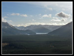
snow at the trailhead so I took my snowshoes. The lake itself is snow
free and almost water free too. I have seen it low but not this low.
The trail is very gentle as it gains 1150" over two miles to the lower
ledge.
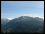
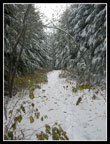
I passed several groups already coming down and a few heading up. The lower trail was snow free though there was a little at the ledge. I took a short break at the lower ledge. Low clouds all around but the sky was mostly blue. I was soon on my way higher. I took another break at the upper ledge. My camera batteries did not like the cold and refused to extend the lens. I warmed them in my hand and they worked for the rest of the day. Lots of color photos that look like black and white. It will be that way for many months.
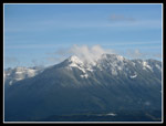
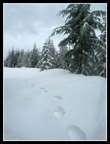
Above the upper ledge the newest trail reroute began. Instead of the old route straight up the ridge it now goes far to the left and switchbacks to the right. This is longer but much gentler. I caught up with two hikers with whom I played leap frog the rest of the way to the summit. One of them was always ahead and I was second or third in line. Snow began soon after the upper ledge and slowly deepened. There were a few footprints before ours. It snowed the day before covering any older prints.
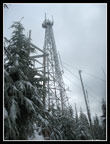
I recognized the old quarry and a few minutes later we reached the road. Snow was about 8 inches deep on the road. It was a little thinner back on trail though the trail was built very wide through here and there are not many trees overhead to catch snow. Coming out of the trees just below the summit ridge the snow was now a foot deep. If I had any distance to go I would have put on the snowshoes. As it was I carried them up and down. The rest of the group of the two hikers I was near coming up were having lunch where the road reaches the ridge. I continued over to the tower.
A few postholes here were more than knee deep. The snow was unconsolidated so ever step was a posthole. I had lunch and headed down. The other group was still enjoying their break. They were not enjoying any views because there were none. Clouds were all around us on the summit. The trip down was much faster. About 2 1/2 hours up and 1 3/4 down. With all the changes to the trail in the decade since my last time on this route it's hard to figure the distance. The first mile is now two and the switchbacks above the upper ledge must add about 1/4 to 1/2 mile. I'm guessing it is a little more than 9 miles round trip now.
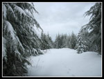
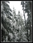
Coming down from the lower ledge I decided to count the hikers I passed. The two miles took about 40 minutes in which time I went by 84 people. This is November and it was below freezing most of the day so I'm sure that was well below average for this trail. Solitude is not a reason to be on this trail. It turned out to be a fun hike. Heavily flocked trees up high and steps to follow in the snow. Not much of a crowd above the lower ledge. A little sunshine to brighten up the day. Not bad for a close in trip.
Click on thumbnails to get larger pictures.
Trips - 2009
Home
I passed several groups already coming down and a few heading up. The lower trail was snow free though there was a little at the ledge. I took a short break at the lower ledge. Low clouds all around but the sky was mostly blue. I was soon on my way higher. I took another break at the upper ledge. My camera batteries did not like the cold and refused to extend the lens. I warmed them in my hand and they worked for the rest of the day. Lots of color photos that look like black and white. It will be that way for many months.
Above the upper ledge the newest trail reroute began. Instead of the old route straight up the ridge it now goes far to the left and switchbacks to the right. This is longer but much gentler. I caught up with two hikers with whom I played leap frog the rest of the way to the summit. One of them was always ahead and I was second or third in line. Snow began soon after the upper ledge and slowly deepened. There were a few footprints before ours. It snowed the day before covering any older prints.
I recognized the old quarry and a few minutes later we reached the road. Snow was about 8 inches deep on the road. It was a little thinner back on trail though the trail was built very wide through here and there are not many trees overhead to catch snow. Coming out of the trees just below the summit ridge the snow was now a foot deep. If I had any distance to go I would have put on the snowshoes. As it was I carried them up and down. The rest of the group of the two hikers I was near coming up were having lunch where the road reaches the ridge. I continued over to the tower.
A few postholes here were more than knee deep. The snow was unconsolidated so ever step was a posthole. I had lunch and headed down. The other group was still enjoying their break. They were not enjoying any views because there were none. Clouds were all around us on the summit. The trip down was much faster. About 2 1/2 hours up and 1 3/4 down. With all the changes to the trail in the decade since my last time on this route it's hard to figure the distance. The first mile is now two and the switchbacks above the upper ledge must add about 1/4 to 1/2 mile. I'm guessing it is a little more than 9 miles round trip now.
Coming down from the lower ledge I decided to count the hikers I passed. The two miles took about 40 minutes in which time I went by 84 people. This is November and it was below freezing most of the day so I'm sure that was well below average for this trail. Solitude is not a reason to be on this trail. It turned out to be a fun hike. Heavily flocked trees up high and steps to follow in the snow. Not much of a crowd above the lower ledge. A little sunshine to brighten up the day. Not bad for a close in trip.
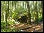 Big Rock |
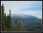 Si & Teneriffe |
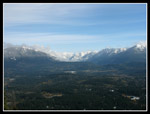 Middle Fork |
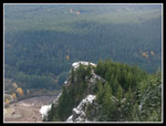 Lower Ledge |
 Chester Morse Lake |
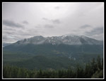
 Mt. Washington |
 Mailbox In Clouds |
 Snow On Ridge |
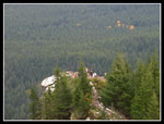
 Summit Tower |
 Deeper Snow |
 Flocked Trees |
 Snow Thins |
 Crowded Ledge |
 Watershed Peaks |
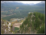 Nearly Empty Lake |
Trips - 2009
Home