5-02-09
My knee is still
sore so I wanted a trail with minimal elevation gain. Some solitude and
flowers would be nice too. It had been a dozen years since I last hiked
the Iron Horse Trail east from South Cle Elum. The trail is in a canyon
far below the noise of I-90. It follows along the Yakima River. It
seemed like a long way to go just to hike in the rain but what the
heck. I didn't get out of Seattle until after 8:00 am. It was 9:30 when
I pulled into Cle Elum. A right at the first light took me to South Cle
Elum and the same road turned east along the river climbing then
descending back to the river, passing under I-90 and taking me to the
small parking lot.
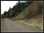
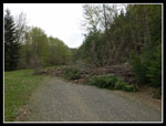
It was 9:50 when I started out under a very cloudy sky. There are a number of changes to the trail since I last hiked it. Dirty wide spots along the first part of the trail are now grassy. There are picnic tables in the first two miles. Two gates span the route. There is a single outhouse in disrepair. A burn has turned a forest to open slopes. There was always some rocks that cascade down from the steep canyon walls. Now there are numerous washouts. One washout has put dirt and logs across the trail. It's easy to get around. A number more have put some dirt on the trail.
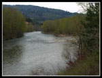
I hoped for a few flowers. I found more than a few. I also found that this canyon is full of birds. I saw geese, ducks, red winged black birds, crows, a woodpecker and more. I also heard hummingbirds all along the route though I did not see them. At about 1 1/2 miles I came to the confluence of the Yakima and Teanaway Rivers. The Teanaway looks nearly as big as the Yakima. Soon I saw a fisherman in a boat. I saw lots of folks fishing from boats and also hip deep wearing waders.
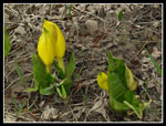
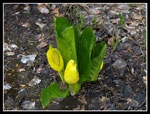
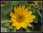
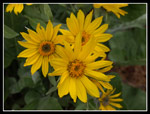
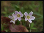
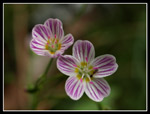
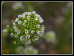
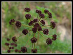
The skunk cabbage started after entering the canyon and kept going for the first few miles. Lots of skunk cabbage. Very odiferous skunk cabbage. At or just past it's peak skunk cabbage. It is all on the right side of the trail. I also saw a lone trillium off the trail and a few false solomons seal. On the left side I found more flowers. A short walk took me to sage, balsamroot, violets, spring beauty, and more. All right at their peak or just before. Quite a show. I had never seen trillium and skunk cabbage and sage and balsamroot near each other.
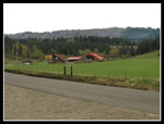
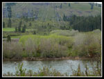
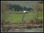
Just before the big powerline swath I saw a gate across the road. I thought my day was over in less than three miles. Barbed wire fence is on both sides of the grade. In fact the sign on the fence says that it is open to hikers and to please lock the gate after passing. Across the river are farms with lots of green grass fields. Old Highway 10 is also across the river. After the powerlines comes the concrete irrigation water slide. When it's full it's pretty impressive. Not full now but there is water. The second gate is here.
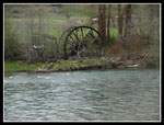
I remembered an old waterwheel on the other side of the river. It was partly buried in small trees. I just couldn't remember exactly where it is. After passing several places that looked right I came to it. The trees have been cut out and it is very easy to see now. A little worse for wear but it's still standing. Along the way were more patches of balsamroot. Across from balsamroot was last years cattails. Amazing.
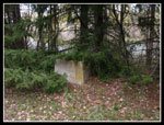
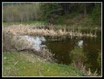
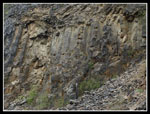
There is a meadow on the right which often has horses. This time there were a dozen or so. A beaver dam has created a big pond here I had never seen. Some interesting reflections in the pond. Beyond here the canyon narrows. Steep on both sides. Around 5 1/2 miles I came to the site of Horlick. The small building on the left next to the railroad grade is all that's left. A little farther is a gated road heading uphill. I believe I saw on old building here on my first visit in 1990. Now the growth is so thick that I couldn't tell if it's still there. A flowering fruit trees tells of an earlier time. The corridor of the railroad grade is narrow and signs warn not to venture from the trail.
On the other side of the river the hillside was now covered with balsamroot. Although Highway 10 is on the other side I seldom saw a car. I did pass a few bikers. One group coming and going. The tunnel comes into view when about half mile away. My knee was really feeling it as I approached the tunnel. A little mist began to fall but it didn't last long. In fact the weather improved on my hike out. I head a consistent loud noise coming from the tunnel. A rustling noise. I heard voices and soon a couple hikers came out. They looked to be about 20 years old. They started in Ellensburg and were heading to Cle Elum. About 26 miles one way, more or less. I thought my 15 mile day was a good workout.
On my first visit to the tunnel I inscribed my name and the date on the concrete. The concrete is soft enough that scraping it with a rock is like using a pen. I have now left 5 dates. The first one was on 4-14-90. I started thinking about whether those two Ellensburg hikers were even born when I first visited. Maybe I am getting old.
The hike back out was a real slog. My knee was hurting and my right foot was hurting. I managed to take a big chunk of skin off. The last mile was a real grind. Still the hike was terrific. Other than the two long distance hikers I saw only one other hiker and that was in the last mile. The clouds really brought out the colors of the flowers without having them blown out by the sun. One of the strangest things is what my altimeter watch showed. I checked it often and the range from highest to lowest point equaled 6 feet. Every time I looked down I seemed to see the same number. I know the river dropped over 7 1/2 miles. At times I could hear it and see some white water. I know I had more than 6 feet of elevation change.
This is a good bike ride. Starting at the South Cle Elum trailhead would make it about 24 miles to the tunnel and back. It is a fine hike too. The first few miles would be great for children as there are picnic tables, flowers, and muddy areas where I saw the skunk cabbage. Farther along there is a lot of solitude. I'm sure I'll visit again and spring turned out to be a great time.
One caveat: Weekends are fine but on weekdays the parking area is a school bus turn around. No parking from 7:00 - 8:00 AM and 3:30 - 4:30 PM.
Click on thumbnails to get larger pictures.
Photo Page 2
Trips - 2009
Home
It was 9:50 when I started out under a very cloudy sky. There are a number of changes to the trail since I last hiked it. Dirty wide spots along the first part of the trail are now grassy. There are picnic tables in the first two miles. Two gates span the route. There is a single outhouse in disrepair. A burn has turned a forest to open slopes. There was always some rocks that cascade down from the steep canyon walls. Now there are numerous washouts. One washout has put dirt and logs across the trail. It's easy to get around. A number more have put some dirt on the trail.
I hoped for a few flowers. I found more than a few. I also found that this canyon is full of birds. I saw geese, ducks, red winged black birds, crows, a woodpecker and more. I also heard hummingbirds all along the route though I did not see them. At about 1 1/2 miles I came to the confluence of the Yakima and Teanaway Rivers. The Teanaway looks nearly as big as the Yakima. Soon I saw a fisherman in a boat. I saw lots of folks fishing from boats and also hip deep wearing waders.
The skunk cabbage started after entering the canyon and kept going for the first few miles. Lots of skunk cabbage. Very odiferous skunk cabbage. At or just past it's peak skunk cabbage. It is all on the right side of the trail. I also saw a lone trillium off the trail and a few false solomons seal. On the left side I found more flowers. A short walk took me to sage, balsamroot, violets, spring beauty, and more. All right at their peak or just before. Quite a show. I had never seen trillium and skunk cabbage and sage and balsamroot near each other.
Just before the big powerline swath I saw a gate across the road. I thought my day was over in less than three miles. Barbed wire fence is on both sides of the grade. In fact the sign on the fence says that it is open to hikers and to please lock the gate after passing. Across the river are farms with lots of green grass fields. Old Highway 10 is also across the river. After the powerlines comes the concrete irrigation water slide. When it's full it's pretty impressive. Not full now but there is water. The second gate is here.
I remembered an old waterwheel on the other side of the river. It was partly buried in small trees. I just couldn't remember exactly where it is. After passing several places that looked right I came to it. The trees have been cut out and it is very easy to see now. A little worse for wear but it's still standing. Along the way were more patches of balsamroot. Across from balsamroot was last years cattails. Amazing.
There is a meadow on the right which often has horses. This time there were a dozen or so. A beaver dam has created a big pond here I had never seen. Some interesting reflections in the pond. Beyond here the canyon narrows. Steep on both sides. Around 5 1/2 miles I came to the site of Horlick. The small building on the left next to the railroad grade is all that's left. A little farther is a gated road heading uphill. I believe I saw on old building here on my first visit in 1990. Now the growth is so thick that I couldn't tell if it's still there. A flowering fruit trees tells of an earlier time. The corridor of the railroad grade is narrow and signs warn not to venture from the trail.
On the other side of the river the hillside was now covered with balsamroot. Although Highway 10 is on the other side I seldom saw a car. I did pass a few bikers. One group coming and going. The tunnel comes into view when about half mile away. My knee was really feeling it as I approached the tunnel. A little mist began to fall but it didn't last long. In fact the weather improved on my hike out. I head a consistent loud noise coming from the tunnel. A rustling noise. I heard voices and soon a couple hikers came out. They looked to be about 20 years old. They started in Ellensburg and were heading to Cle Elum. About 26 miles one way, more or less. I thought my 15 mile day was a good workout.
On my first visit to the tunnel I inscribed my name and the date on the concrete. The concrete is soft enough that scraping it with a rock is like using a pen. I have now left 5 dates. The first one was on 4-14-90. I started thinking about whether those two Ellensburg hikers were even born when I first visited. Maybe I am getting old.
The hike back out was a real slog. My knee was hurting and my right foot was hurting. I managed to take a big chunk of skin off. The last mile was a real grind. Still the hike was terrific. Other than the two long distance hikers I saw only one other hiker and that was in the last mile. The clouds really brought out the colors of the flowers without having them blown out by the sun. One of the strangest things is what my altimeter watch showed. I checked it often and the range from highest to lowest point equaled 6 feet. Every time I looked down I seemed to see the same number. I know the river dropped over 7 1/2 miles. At times I could hear it and see some white water. I know I had more than 6 feet of elevation change.
This is a good bike ride. Starting at the South Cle Elum trailhead would make it about 24 miles to the tunnel and back. It is a fine hike too. The first few miles would be great for children as there are picnic tables, flowers, and muddy areas where I saw the skunk cabbage. Farther along there is a lot of solitude. I'm sure I'll visit again and spring turned out to be a great time.
One caveat: Weekends are fine but on weekdays the parking area is a school bus turn around. No parking from 7:00 - 8:00 AM and 3:30 - 4:30 PM.
 Farm Opposite Start |
 First Skunk Cabbage |
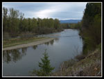 Yakima River |
 Mud Slide |
 Largest Slide |
 Blooming Skunk Cabbage |
 Old RR Signal Base |
 Wide Stretch |
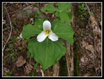 Day's Lone Trillium |
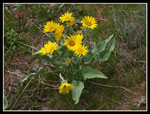 Bring On The Balsamroot |
 Close Up |
 Trifecta |
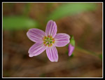 Spring Beauty |
 Different Color |
 Another Duo |
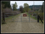 The First Gate |
 Wetland |
 Powerlines |
 Farm Across River |
 Blooming Something |
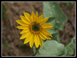 Another Balsamroot |
 Unknown Bloom |
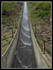 Water Chute |
 Rock Wall |
 Old Waterwheel |
Photo Page 2
Trips - 2009
Home