2-16-09
Kim and I headed
north for a Presidents Day hike. I first hiked to Oyster Dome in
2005(map at link). Last year I returned with Suzanne for a
trip completely
on snow. Later in the year Kim and I visited but did not make it to the
viewpoint. This would be a good time for a return visit. On each of my
previous visits I started on the east side of Blanchard Hill rather
than off of Chuckanut Drive. This allows for more miles, many fewer
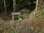
people, lakes, and a variety of loops. We parked at the upper trailhead
just a few miles from exit 240 off I-5. There were two cars already
there. It was cold and cloudy though it was supposed to clear up and
warm up.
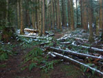
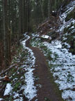
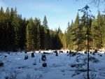
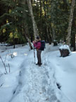
We walked up the gated road to the Alternate Incline Trail. We had some views though the top of Mt. Baker was in the clouds. On my first visit only four years ago there was only a small sign off the road. The Incline Trail was there along with the Alternate Incline Trail. Now the Incline Trail is unsigned and hard to find. It is definitely closed. The upper end was much easier to see. The newer trail gently climbs up the hillside. There is a lot of green with the fir trees, moss, and underbrush. As we climbed we began to see small patches of snow. We passed the unsigned upper end of the old Incline Trail and began to see the old logging remnants.
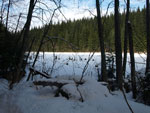
When we reached the junction with the Pacific Northwest Trail. there was snow all over the trail. It was hard. A motorcycle track was right in the middle. It was deep enough to make it hard to walk in the narrow trench and hard not too. What was a motorcycle doing up there? A short walk to the right led to Lizard Lake. It is completely snow covered. A few photos and we headed back to the junction,. It was 11:00 already so we stopped for part of our lunches.
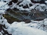
The railroad grade over to Lily Lake is pretty flat. The snow came and went but began to get a little deeper nearer to Lily Lake. We reached the Lily Lake junction and continued on the PNT. That would be our route back. There were fresh footprints in the snow and they were headed the opposite way. We passed the turn off to Lily Lake and continued on. The creek here lined with skunk cabbage in the spring but not a single one has sprouted through the snow.
The route begins a gently descent. We soon crossed the creek to the left bank. We soon crossed back over. Puget Sound was visible in peek-a-boo looks through the forest. The junction with the Oyster Trail still does not have any signs. We stayed right heading towards the Dome. The icy snow was more than a little slick and I hoped it would not be too slick on the last climb to the viewpoint. We finally met the first hikers of the day. They said that the snow actually disappeared up ahead.
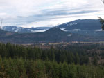
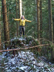
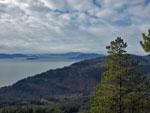
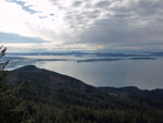
One more climb and we topped out at the viewpoint There was only one other group there. We went to the highest point and had an unobstructed view to the west. It had been clearing and soon the sky was mostly blue. It was not all that warm but the sun made it feel like spring. We had a long lunch and enjoyed the views. Groups come and went. This in a popular place. Fortunately the vast majority take the short trail and avoid our route.
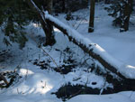
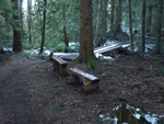
It's amazing how close the Sound is. The San Juan Islands were also right in front of us. All too soon we packed up and started down. We retraced our steps to the Lily Lake turn off and shortly after that reached the Lily Lake Trail. We found signs of very recent work on this trail. All downed trees have been logged out and a number of drainage ditches have been dug. The trail contours all over the side of the mountain. It is not the most direct route down but it is gentle on the knees. It crosses a number of small creeks some on bridges and some with easy rock hops.
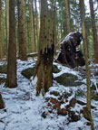
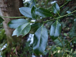
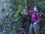
One biker zoomed by us. I was surprised to not see any hikers coming up. We did see one thing I have never seen before. There is a tree right next to the trail. It is about 40 feet tall. It is covered in green leaves -- in February. The leaves are partly serrated like holly leaves. They are more rounded that holly and some had only one or even no serrations. Some small branches hang down like vines. What the heck is it? We have no idea. It would not stand out in the spring with the alder and maples are leafed out. In February it sure does.
After what seemed like a mile heading away from the trailhead we finally switched back and headed for the car. The road to the Samish Overlook comes into view long before the end. We just kept hiking a short distance above the road and never seemed to get closer. We met two more bikers who were coming down. It certainly was not crowded along our route. The sun was now low and it was getting pretty darn cold. I had gloves on all the way down. It felt about 25 degrees cooler at the car than at the viewpoint. When we returned there were no other cars.
This was a nice day on the trail. We had some snow but not enough to need gaiters. The sunshine at the viewpoint was a nice bonus. That weird tree was worth the hike by itself. After my steep and deep snow slog at Red Mountain on Saturday it was nice to hike on some dirt in the forest. We were too early for any flowers but still had a very nice time.
Kim's report is here: Nwhikers Report & Photos
Click on thumbnails to get larger pictures.
Trips - 2009
Home
We walked up the gated road to the Alternate Incline Trail. We had some views though the top of Mt. Baker was in the clouds. On my first visit only four years ago there was only a small sign off the road. The Incline Trail was there along with the Alternate Incline Trail. Now the Incline Trail is unsigned and hard to find. It is definitely closed. The upper end was much easier to see. The newer trail gently climbs up the hillside. There is a lot of green with the fir trees, moss, and underbrush. As we climbed we began to see small patches of snow. We passed the unsigned upper end of the old Incline Trail and began to see the old logging remnants.
When we reached the junction with the Pacific Northwest Trail. there was snow all over the trail. It was hard. A motorcycle track was right in the middle. It was deep enough to make it hard to walk in the narrow trench and hard not too. What was a motorcycle doing up there? A short walk to the right led to Lizard Lake. It is completely snow covered. A few photos and we headed back to the junction,. It was 11:00 already so we stopped for part of our lunches.
The railroad grade over to Lily Lake is pretty flat. The snow came and went but began to get a little deeper nearer to Lily Lake. We reached the Lily Lake junction and continued on the PNT. That would be our route back. There were fresh footprints in the snow and they were headed the opposite way. We passed the turn off to Lily Lake and continued on. The creek here lined with skunk cabbage in the spring but not a single one has sprouted through the snow.
The route begins a gently descent. We soon crossed the creek to the left bank. We soon crossed back over. Puget Sound was visible in peek-a-boo looks through the forest. The junction with the Oyster Trail still does not have any signs. We stayed right heading towards the Dome. The icy snow was more than a little slick and I hoped it would not be too slick on the last climb to the viewpoint. We finally met the first hikers of the day. They said that the snow actually disappeared up ahead.
One more climb and we topped out at the viewpoint There was only one other group there. We went to the highest point and had an unobstructed view to the west. It had been clearing and soon the sky was mostly blue. It was not all that warm but the sun made it feel like spring. We had a long lunch and enjoyed the views. Groups come and went. This in a popular place. Fortunately the vast majority take the short trail and avoid our route.
It's amazing how close the Sound is. The San Juan Islands were also right in front of us. All too soon we packed up and started down. We retraced our steps to the Lily Lake turn off and shortly after that reached the Lily Lake Trail. We found signs of very recent work on this trail. All downed trees have been logged out and a number of drainage ditches have been dug. The trail contours all over the side of the mountain. It is not the most direct route down but it is gentle on the knees. It crosses a number of small creeks some on bridges and some with easy rock hops.
One biker zoomed by us. I was surprised to not see any hikers coming up. We did see one thing I have never seen before. There is a tree right next to the trail. It is about 40 feet tall. It is covered in green leaves -- in February. The leaves are partly serrated like holly leaves. They are more rounded that holly and some had only one or even no serrations. Some small branches hang down like vines. What the heck is it? We have no idea. It would not stand out in the spring with the alder and maples are leafed out. In February it sure does.
After what seemed like a mile heading away from the trailhead we finally switched back and headed for the car. The road to the Samish Overlook comes into view long before the end. We just kept hiking a short distance above the road and never seemed to get closer. We met two more bikers who were coming down. It certainly was not crowded along our route. The sun was now low and it was getting pretty darn cold. I had gloves on all the way down. It felt about 25 degrees cooler at the car than at the viewpoint. When we returned there were no other cars.
This was a nice day on the trail. We had some snow but not enough to need gaiters. The sunshine at the viewpoint was a nice bonus. That weird tree was worth the hike by itself. After my steep and deep snow slog at Red Mountain on Saturday it was nice to hike on some dirt in the forest. We were too early for any flowers but still had a very nice time.
Kim's report is here: Nwhikers Report & Photos
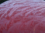 Ice Patterns On My Car |
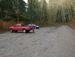 Upper Trailhead |
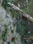
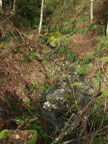 Creek |
 View West |
 Start Of Alt Incline Trail |
 First Snow |
 Kim Is Stumped |
 Lizard Lake |
 Icicle |
 PNT |
 Old Snag |
 Oyster Dome View NW |
 Oyster Dome View SW |
 Snowy Reflection |
 Dry Beaver Pond |
 Sun On Snow |
 Shooting The Shooter |
 Benches Near Creek |
 Mystery Leaves |
 Vine Like Branch |
Trips - 2009
Home