1-31-09
I really needed
a nice long
hike to get rid of some stress. Where to get long mileage and few
people with a short drive and minimal snow? West Rattlesnake Mountain
via the road. Although it's
a short drive I was not moving very early and it was 9:20 by the time I
reached the parking spot. The start is just south of I-90 off Highway
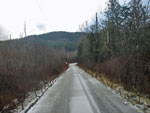
18. As expected, there were no other cars to be found. The gate was
locked and I was off on the paved road. The pavement only lasts for
about half a mile. I passed the power line station and left
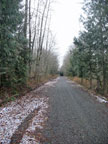
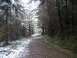
civilization behind. The route is pretty flat until the 2 1/2 mile
marker. Just after that I reached Canyon Creek.
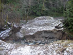
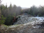
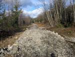
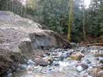
The creek goes under the road in a big culvert. Well, at least it used to. The road is blocked by big boulders and a route goes steeply uphill into a clear cut. I believe that will avoid the missing road and get back onto the old route higher up. I chose to pass the boulders and take a look. In short order I came to the creek. The recent flooding overwhelmed the culvert and washed away the road. I had a muddy descent to the creek and a wide rock hop to get across. Climbing up the other side was on mud.
No cars are getting through that though I did see ATV tracks making it across. It was sub freezing at the start and there was even ice on the paved part. Now it was time to start climbing and I warmed up fast. Part way up the hill I came to another washout that was older. That one was fresh on my last visit back in 2003 after another big fall storm. Now it's been repaired though the lower one may never be.
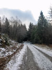
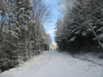
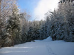
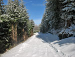
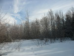
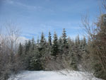
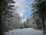
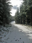
The road flattens again at the 3 1/2 mile marker. I made it that far in 62 minutes. Another road goes off uphill here then turns to the west. That is where I believe the reroute comes out. I was up to about 2800' but still found no snow. That soon changed as small snow patches began. The gated turn to the summit came up at about 4 3/4 miles. The gate was open. More than half the elevation gain comes in the last 3 1/4 miles. The road is steeper but still not all that steep. There were a number of branches down but none were a problem to get over. When the snow cover became thicker I could see truck tracks. None since a recent snow fall but still very visible.
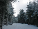
The snow was hard and I only sank down a few inches. My gaiters spent the whole trip in my pack. There were several viewpoints along the road. Emphasis on "was". Now the trees have grown back to the extent that only peek a boo views over towards Tiger Mountain are left. One small gravel pit is turning into an alder forest. My pace slowed on snow but I still kept up a steady pace. Other than one water break and photos I did not stop all the way up. The road finally made a sharp right turn and the towers came into view. I wasn't sure if I wanted to go to Grand Prospect or the real summit.
The trees here are so thick I doubt I could get through them. A small alder meadow opened up and I thought that led to just above the Rattlesnake Mountain Trail. There was a little blue sky so I chose to head towards the RMT and Grand Prospect. A short fight through alder and indeed I was just above the RMT. I dropped down within less than a quarter mile of Grand Prospect. Right near GP I met the only hiker I was to see all day. He was heading down.
We hiked the RMT end to end at the start of the month and at that time the benches and map were buried under a lot of snow. The benches are still buried but the map is now in the open. Looks like at least a couple feet less snow now. There were some foot steps heading on towards the east peak but they were under new snow. Nobody had been through yet this day. The RTM itself was a series of icy steps on the short part I hiked. Not too bad since the steps were deep but very slick. My untouched snowy road was much easier walking.
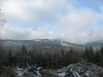
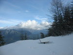
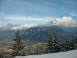
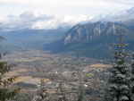
It was a bit windy and I had to bundle up. Most of Mt. Si was in the open though a cloud was near the summit. I arrived at GP at 11:58 am. Just about 2:40 to hike 8 miles with 2300' net gain. Not as fast as many but a pretty good time for me. In less than 15 minutes I was ready to get moving again. I found the exit from the RMT with no trouble and then back through the alder to the road. I had time to go on to the real summit but not the inclination. Down I went. It must have warmed up a bit because after a few miles down the trees began to rain with melting snow. By the time I reached the open gate the lower road was too wide for overhanging branches to drip on me. Back at the 3 1/2 mile marker I had some views out to Tiger and Taylor Mountains. There was noticeably less snow on the trees than just a few hours earlier.
I dropped back to the washout at Canyon Creek. I thought that melting snow might submerge the rocks I hopped across but that did not prove to be true. At about the two mile mark I ran into a strange group. One motorcycle was followed by 4 or 5 mini jeeps. They were somewhere between a jeep and a golf cart in size and had two folks in each. They stopped to say hi. Some kind of club I guess. They must have had keys as the first gate has pretty deep water on either side. No way to go around it. That one minute meeting and the lone hiker near the top were the only folks I saw all day.
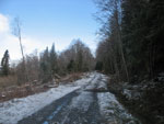
My feet were getting sore as I reached the last half mile of pavement. I finished up at 3:00 pm on the dot. It actually took me 10 minutes longer to descend. Total time was 5:42 with 5:30 spent walking. I covered 16 miles with 2500' of gain. I achieved what I set out to do. I walked a long way, had some views, had untrammeled snow all the way up, saw almost nobody, and was home well before dark. Not a bad way to spend a winter day.
Click on thumbnails to get larger pictures.
Trips - 2009
Home
The creek goes under the road in a big culvert. Well, at least it used to. The road is blocked by big boulders and a route goes steeply uphill into a clear cut. I believe that will avoid the missing road and get back onto the old route higher up. I chose to pass the boulders and take a look. In short order I came to the creek. The recent flooding overwhelmed the culvert and washed away the road. I had a muddy descent to the creek and a wide rock hop to get across. Climbing up the other side was on mud.
No cars are getting through that though I did see ATV tracks making it across. It was sub freezing at the start and there was even ice on the paved part. Now it was time to start climbing and I warmed up fast. Part way up the hill I came to another washout that was older. That one was fresh on my last visit back in 2003 after another big fall storm. Now it's been repaired though the lower one may never be.
The road flattens again at the 3 1/2 mile marker. I made it that far in 62 minutes. Another road goes off uphill here then turns to the west. That is where I believe the reroute comes out. I was up to about 2800' but still found no snow. That soon changed as small snow patches began. The gated turn to the summit came up at about 4 3/4 miles. The gate was open. More than half the elevation gain comes in the last 3 1/4 miles. The road is steeper but still not all that steep. There were a number of branches down but none were a problem to get over. When the snow cover became thicker I could see truck tracks. None since a recent snow fall but still very visible.
The snow was hard and I only sank down a few inches. My gaiters spent the whole trip in my pack. There were several viewpoints along the road. Emphasis on "was". Now the trees have grown back to the extent that only peek a boo views over towards Tiger Mountain are left. One small gravel pit is turning into an alder forest. My pace slowed on snow but I still kept up a steady pace. Other than one water break and photos I did not stop all the way up. The road finally made a sharp right turn and the towers came into view. I wasn't sure if I wanted to go to Grand Prospect or the real summit.
The trees here are so thick I doubt I could get through them. A small alder meadow opened up and I thought that led to just above the Rattlesnake Mountain Trail. There was a little blue sky so I chose to head towards the RMT and Grand Prospect. A short fight through alder and indeed I was just above the RMT. I dropped down within less than a quarter mile of Grand Prospect. Right near GP I met the only hiker I was to see all day. He was heading down.
We hiked the RMT end to end at the start of the month and at that time the benches and map were buried under a lot of snow. The benches are still buried but the map is now in the open. Looks like at least a couple feet less snow now. There were some foot steps heading on towards the east peak but they were under new snow. Nobody had been through yet this day. The RTM itself was a series of icy steps on the short part I hiked. Not too bad since the steps were deep but very slick. My untouched snowy road was much easier walking.
It was a bit windy and I had to bundle up. Most of Mt. Si was in the open though a cloud was near the summit. I arrived at GP at 11:58 am. Just about 2:40 to hike 8 miles with 2300' net gain. Not as fast as many but a pretty good time for me. In less than 15 minutes I was ready to get moving again. I found the exit from the RMT with no trouble and then back through the alder to the road. I had time to go on to the real summit but not the inclination. Down I went. It must have warmed up a bit because after a few miles down the trees began to rain with melting snow. By the time I reached the open gate the lower road was too wide for overhanging branches to drip on me. Back at the 3 1/2 mile marker I had some views out to Tiger and Taylor Mountains. There was noticeably less snow on the trees than just a few hours earlier.
I dropped back to the washout at Canyon Creek. I thought that melting snow might submerge the rocks I hopped across but that did not prove to be true. At about the two mile mark I ran into a strange group. One motorcycle was followed by 4 or 5 mini jeeps. They were somewhere between a jeep and a golf cart in size and had two folks in each. They stopped to say hi. Some kind of club I guess. They must have had keys as the first gate has pretty deep water on either side. No way to go around it. That one minute meeting and the lone hiker near the top were the only folks I saw all day.
My feet were getting sore as I reached the last half mile of pavement. I finished up at 3:00 pm on the dot. It actually took me 10 minutes longer to descend. Total time was 5:42 with 5:30 spent walking. I covered 16 miles with 2500' of gain. I achieved what I set out to do. I walked a long way, had some views, had untrammeled snow all the way up, saw almost nobody, and was home well before dark. Not a bad way to spend a winter day.
 Icy Road |
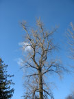
 Past It's Prime |
 Flat At First |
 New Washout |
 Old Washout |
 Snow Now On Road |
 Taylor Mountain |
 Small Trees Down |
 Soft Dirt & Needles |
 Snow On Branch |
 Snowy Ferns |
 More Snow & Blue Sky |
 A Mile To Go |
 Snow Covered Tracks |
 Tower In Sight |
 Map Has Melted Out |
 Si Summit In Clouds |
 Sun On North Bend |
 Just Off RMT |
 Back On The Road |
 Scenic Road |
 Back Into Clouds |
 Small Washout |
 Creek Level View |
 One Big Tree |
Trips - 2009
Home