4-17-11
After
three plus months of close to
Seattle trail trips I finally had time to get in a full day snow
scramble. Avalanche danger was high near the crest so we headed far to
the east. We also hoped to get some rare sunshine. It took several
stops to get everyone together. We cruised over Snoqualmie Pass in
clouds and light rain. By Easton it began to clear. North on 970 then
Highway 97 to Mineral Springs. It was cold but mostly sunny as we
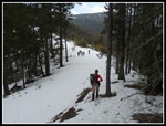
packed up and headed out. The first surprise was the lack of snow at
the start. The Cascade crest received two plus feet during the past
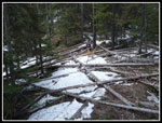
week. It was bare dirt at the 2700' start.
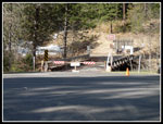
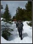
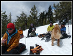
We crossed the highway and jumped the gated entrance to the campgrounds. There is still a little snow there. We quickly found the road heading west out of the campgrounds. Carla brought skis and expected to be using them early. It was not to be. There was some snow on the road early on but then more dirt. The mostly bare road was easy walking. We hiked alongside Medicine Creek up to where the road splits. We went left across the creek on a bridge. Immediately we left the road and headed up.
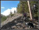
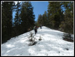
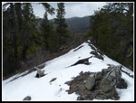
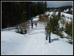
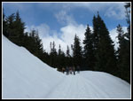
There was snow on the road but as we started up the ridge it was in forest and the snow was very thin. We had a map with a GPS track posted my Matt at nwhikers. We did not have a GPS unit but did have at least three phones with maps and GPS. Route finding was made much easier. The ridge had a number of ups and downs. None very big but they added up. At one drop to a saddle we had to cross many small downed logs. Tedious but not that hard. We were able to stay very near the crest of the ridge all the way.
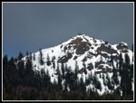
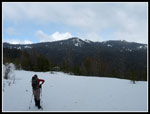
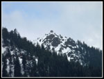
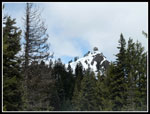
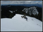
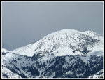
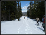
After cresting Pt. 4035 we dropped steeply down the right side to a road and another saddle. The road provided a good look out to peaks near Blewett Pass and a good look at our destination. The lookout still looked to be a long way away. The snow was deeper in the open but hard enough to allow us to keep our snowshoes on our packs. We headed back into forest until reaching another road. There are a bunch of old and newer logging roads. We left that road and headed straight uphill aiming for the main road to the lookout from Highway 97. We planned to reach that road near where it switches back and heads north to the lookout.
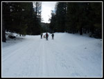
The snow here was softer. We sank in 6' or more in spots. I managed to post hole my whole leg. It took some time to get myself out. I was the last one to reach the main road. We reached it right at the switchback. Nice job of route finding. Now it was just a road slog. We made good time though the snow began to soften. I grew tired of sinking in and stopped to put on snowshoes. Clouds had been slowly moving in and it was markedly cooler near the top of the ridge. The road is just below the ridge crest and blocked any wind.
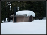
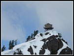
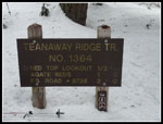
A sign for Red Top was almost entirely buried. Just a corner with "Re" showed above the snow. Many years ago I drove up to the parking lot and made the long 10 minute hike to the lookout. In 2008 a group of us including Suzanne, Barry, and David, on this trip, climbed up to the lookout from the Teanaway side. That was a long day. This trip was much easier. We had another very close look at the lookout. Just a few hundred feet of climbing to go. A nice new outhouse graces the trailhead. Most folks put on jackets as we could hear the wind above.
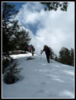
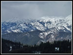
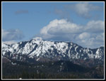
The final climb is pretty steep. The snow was wind blown and harder here. Snowshoe crampons dug in well as we ascended. It was mostly white overhead but most peaks were in the open. The exception was the Stuart Range. It was buried behind white clouds. I have only used my Atlas snowshoes a few times and it was challenging to traverse steep slopes with confidence. A slip would have meant a long slide. The wind was blowing hard at the lookout. I had to dig out a jacket and gloves. My thermometer read 29 degrees. It was very warm heading up the lower ridge in the morning sun but darn right frigid on top.
We snapped some photos and decided to have lunch down off the summit. The snowshoes did fine on the descent. It seemed a whole lot warming out of the wind. After lunch we headed down. A few minutes later we were back at the summer trailhead and we found a lone skier. Roger from nwhikers had skied the longer route up the main road. Gayle skied and hiked and was farther below. Always fun to run into a friend on a deserted mountain. Carla chose to ski down with Roger. The other seven of us retraced out ridge route.
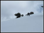
Other than the ups and downs on the ridge the way down was pretty easy. It took us from 9:30 am to about 12:50 to hike up. We chopped an hour off the descent. When we reached the point where we had dropped off Point 4035 we chose to try contouring around it. I'm not sure if it was easier or harder. It required traversing on steep hard snow. Harder on the ankles but we did reach the ridge again at a similar elevation. Once back on the ridge our snowshoes came off for good. From there it was just up and down with a whole lot more down.
We made it back to the cars just after 3:30 pm. On the 2008 trip up Red Top I logged in 13 miles with 4200' of gain. There was a short road walk after a long cross country ridge climb. This trip was a much easier ridge climb and more road walking. Less snow down low and firm snow up high made it pretty easy. I calculated 2650' of net gain but with ups and downs it added up to about 3300'. Eric recorded 10.9 miles round trip. The avalanche danger is fairly low as we were on a ridge top much of the way. Not zero but pretty low. The real lack of recent snow this far east made this a good option when areas nearer the crest of the mountains were very dangerous.
We had pretty good weather. Sun early and again late with a little light snowfall near the top. The wind was a little disappointing as it cut our summit time down but it was no problem once off the top. Good company and another new route made for a fun day in the mountains.
Suzanne posted a report here: NWHikers Report & Photos
Click on thumbnails to get
larger pictures.
Trips - 2011
Home
We crossed the highway and jumped the gated entrance to the campgrounds. There is still a little snow there. We quickly found the road heading west out of the campgrounds. Carla brought skis and expected to be using them early. It was not to be. There was some snow on the road early on but then more dirt. The mostly bare road was easy walking. We hiked alongside Medicine Creek up to where the road splits. We went left across the creek on a bridge. Immediately we left the road and headed up.
There was snow on the road but as we started up the ridge it was in forest and the snow was very thin. We had a map with a GPS track posted my Matt at nwhikers. We did not have a GPS unit but did have at least three phones with maps and GPS. Route finding was made much easier. The ridge had a number of ups and downs. None very big but they added up. At one drop to a saddle we had to cross many small downed logs. Tedious but not that hard. We were able to stay very near the crest of the ridge all the way.
After cresting Pt. 4035 we dropped steeply down the right side to a road and another saddle. The road provided a good look out to peaks near Blewett Pass and a good look at our destination. The lookout still looked to be a long way away. The snow was deeper in the open but hard enough to allow us to keep our snowshoes on our packs. We headed back into forest until reaching another road. There are a bunch of old and newer logging roads. We left that road and headed straight uphill aiming for the main road to the lookout from Highway 97. We planned to reach that road near where it switches back and heads north to the lookout.
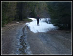
The snow here was softer. We sank in 6' or more in spots. I managed to post hole my whole leg. It took some time to get myself out. I was the last one to reach the main road. We reached it right at the switchback. Nice job of route finding. Now it was just a road slog. We made good time though the snow began to soften. I grew tired of sinking in and stopped to put on snowshoes. Clouds had been slowly moving in and it was markedly cooler near the top of the ridge. The road is just below the ridge crest and blocked any wind.
A sign for Red Top was almost entirely buried. Just a corner with "Re" showed above the snow. Many years ago I drove up to the parking lot and made the long 10 minute hike to the lookout. In 2008 a group of us including Suzanne, Barry, and David, on this trip, climbed up to the lookout from the Teanaway side. That was a long day. This trip was much easier. We had another very close look at the lookout. Just a few hundred feet of climbing to go. A nice new outhouse graces the trailhead. Most folks put on jackets as we could hear the wind above.
The final climb is pretty steep. The snow was wind blown and harder here. Snowshoe crampons dug in well as we ascended. It was mostly white overhead but most peaks were in the open. The exception was the Stuart Range. It was buried behind white clouds. I have only used my Atlas snowshoes a few times and it was challenging to traverse steep slopes with confidence. A slip would have meant a long slide. The wind was blowing hard at the lookout. I had to dig out a jacket and gloves. My thermometer read 29 degrees. It was very warm heading up the lower ridge in the morning sun but darn right frigid on top.
We snapped some photos and decided to have lunch down off the summit. The snowshoes did fine on the descent. It seemed a whole lot warming out of the wind. After lunch we headed down. A few minutes later we were back at the summer trailhead and we found a lone skier. Roger from nwhikers had skied the longer route up the main road. Gayle skied and hiked and was farther below. Always fun to run into a friend on a deserted mountain. Carla chose to ski down with Roger. The other seven of us retraced out ridge route.
Other than the ups and downs on the ridge the way down was pretty easy. It took us from 9:30 am to about 12:50 to hike up. We chopped an hour off the descent. When we reached the point where we had dropped off Point 4035 we chose to try contouring around it. I'm not sure if it was easier or harder. It required traversing on steep hard snow. Harder on the ankles but we did reach the ridge again at a similar elevation. Once back on the ridge our snowshoes came off for good. From there it was just up and down with a whole lot more down.
We made it back to the cars just after 3:30 pm. On the 2008 trip up Red Top I logged in 13 miles with 4200' of gain. There was a short road walk after a long cross country ridge climb. This trip was a much easier ridge climb and more road walking. Less snow down low and firm snow up high made it pretty easy. I calculated 2650' of net gain but with ups and downs it added up to about 3300'. Eric recorded 10.9 miles round trip. The avalanche danger is fairly low as we were on a ridge top much of the way. Not zero but pretty low. The real lack of recent snow this far east made this a good option when areas nearer the crest of the mountains were very dangerous.
We had pretty good weather. Sun early and again late with a little light snowfall near the top. The wind was a little disappointing as it cut our summit time down but it was no problem once off the top. Good company and another new route made for a fun day in the mountains.
Suzanne posted a report here: NWHikers Report & Photos
 Little Snow At The Start |
 Carla Ran Out Of Snow |
 Bare Ground & Blue Sky |
 First View Of Lookout |
 Obstacle Course |
 Snow On The Ridge |
 Climbing Higher |
 Still On The Ridge Top |
 Descending From Pt 4035 |
 Summit In The Distance |
 Summit Close Up |
 Sun On The Road |
 Back Off Road |
 On The Main Road |
 Buried Sign |
 Partly Buried Outhouse |
 Lookout From Trailhead |
 Red Top Lookout |
 Trailhead Sign |
 Last Steep Slope |
 Corniced Ridge |
 Rain, Snow, & Sunshine |
 View North |
 Table Mountain Area |
 Sun On Slopes |
 Lunch Time |
 Heading Down The Road |
 Snow Is Softening |
 Last View Out |
 Gus Being Gus |
Trips - 2011
Home