7-15-17
Gary
and I debated ideas for an overnight trip or a day trip. With clear
skies we chose a strenuous trip to a high viewpoint. John was free and
signed on too. I had not hiked up Sulphur Mountain until the Suiattle
River Road washed out. It was closed at Downey Creek in 2003 then
eleven miles from the end in 2006. In 2007
Kim and I biked to the end of the road and camped. On day two we hiked
up Sulphur Mountain. Kim had been most of the way up before being
stepped by deep snow. It was a first ascent for each of us.
Unfortunately, clouds blocked much of the views. In 2013
we made another bike approach. We had better weather but the summit of
nearby Glacier Peak was once again in the clouds. Finally, the road was
opened in late 2014
and we and friends hiked up Sulphur on 11-16-14. There was a little
snow starting a mile from the top and we finally had clear skies and
great views. With the short days we came out in the dark. The hike is
10 miles round trip with 4700' of total elevation gain. It is no easy
hike. By now I was convinced that this would be an every few years trip
to repeat.
Much to my surprise Gary checked his fifty year long hike log and found he had never been up Sulphur Mountain. John had not been up either. A trip where my three visits were the total for all three of us. Since the Suiattle River Road has about 13 miles of gravel and since I had driven it just two weeks earlier and saw it has not been regraded this year we chose an early start. We met in Lynnwood at 6:15 am and headed north. Through Arlington, Darrington, and north to the Suiattle River Road. The paved part went fast then came the gravel. Much of it is good but there are sections with lots of pot holes. With a sedan I took it slower. We reached the end of the road (1600') at about 8:15 am. By 8:24 we were on our way. The lot was more than half full.
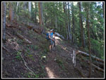
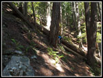
We walked a very short distance until the sign for Sulphur Mountain. The route starts up very steeply. A quick warm up. There is one big log down that has forced a route up the slope cutting a switchback. After a quick 300' climb we gave 60' back. The route drops to a very old bridge over a very small creek. This is the only place to get water on the entire trip. There is a small spring that is dribbling water across the trail about 1.5 miles up but there is very little water. These two water sources are the only places where devils club was seen. Just after the bridge is another big mess of down trees. Unlike in 2014 there is now a boot path that connects back tot the trail. From here on up all down logs were step or climb across with one exception. More on that later.
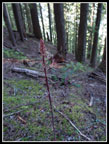
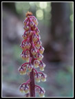
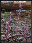
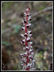
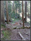
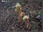
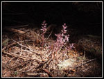
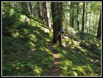
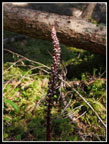
There are a few spots down low where there is a lot of salal along the trail. Not too brushy but the trail is narrow. After that any ground cover is intermittent. For the most part the ground is bare and the forest is dark. Very unusual on the wet side of the mountains. Soon the grade picks up and remains moderately steep and steady most of the way. There are some shorter much steeper spots as well. This route climbs a total of 4700' with smooth tread, a few roots and rocks, and a few steep climbs up the fall line. Most of the way is a series of many switchbacks. Once a steady pace was set we ground out the elevation gain. We did stop numerous times for photos. For the second time in a few weeks in this area I saw a huge amount of saprophytes. These are plants that do not have chlorophyll and so do not use the sun. They are white, yellow, pink, and even red and white striped. No green to be seen. It is difficult to photograph them in dim lighting. We all had many blurry shots as well as some very good ones. I see them at times but seldom in the profusion that is found above the Suiattle River.
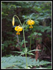
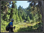
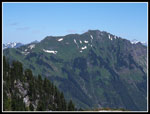
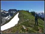
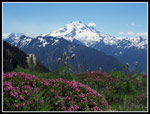
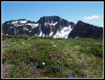
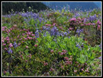
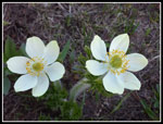
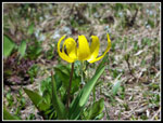
The switchbacks go by with no seeming end in sight. At last we reached a flatter spot and took a break. This is at about 4800'. Still 1400' to go. A very brief flattish spot gives way to a very steep short climb. Now the trail settles down to a more gentle traverse. We saw some tiger lilies along here. There is also an obvious old trail heading up the slope. I've noticed it on each trip but not yet explored where it goes. The traverse crosses below a boulder field then starts to switchback up the far side. From here it is just more switchbacks until the trees finally begin to thin. Now there is heather meadows with Valerian, cinquefoil and other flowers. We had a few views out to the west including Green Mountain.
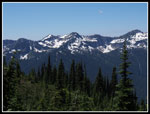
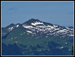
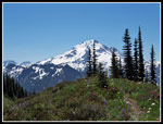
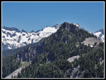
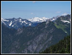
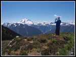
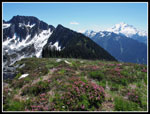
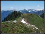
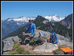
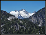
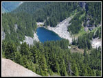
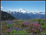
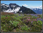
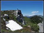
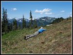
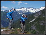
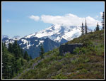
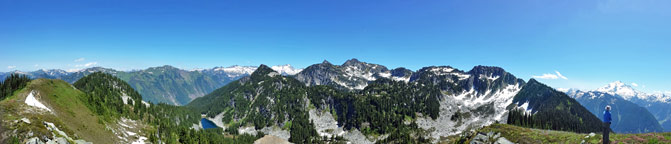
Though it was a warm day, we were in much cooler forest until near the top. There was one small snow patch below the top but it was easy to avoid it. At 12:13 pm we reached the first summit. Great views now to the north, west, and south. The real summit of Sulphur and its ridge blocked our view to the east. Dome Peak is to the north and Glacier Peak to the southeast. This is a great viewpoint for both. The summit ridge is filled with blooming wildflowers. Lots of different colors. We saw a few glacier lilies still in bloom. There is one snow patch just below the ridge on the north side. In the near term one could bivy on top and melt snow for water. Sulphur Lake is quite visible far below to the northwest. We took photos then headed on to the slightly higher summit. At 6200' that old lookout site is still more than 500' below the actual summit. There is a steep drop before climbing to the actual summit. 4700' of gain was enough for us this day.
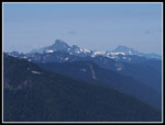
This is among the best views of Glacier Peak. The north side is much icier than the south and more photogenic. We could see far out to the west to Whitehorse and Three Fingers Mountains. With long days and no bike ride out we had lots of time. In fact, we spent two hours on the summit. After half an hour two other hikers came up. Not exactly a crowd. We took lots of photos as the conditions were excellent. It would have been nicer to be earlier for better lighting but the blue sky and a few wispy clouds was still pretty good. We headed part way back first and found a little shade. The sun was quite intense. At 2:33 pm we headed down. The two other hikes went down half an hour earlier. We had put on long sleeves and pant legs on top for sun protection. A short way down we took them off when entering the shady forest.
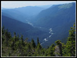
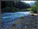
The trip down was much faster. We took some photo stops but fewer than on the way up. Our only rest stop was at the flattish spot. 4700' is a lot of downhill. The soft tread and general lack of steps helped a lot. About two thirds of the way down we reached the one log we could not get over. It has little bark, is very slick, is big, and lays across the trail on a steep slope. On the way up we followed boot prints up the slope and around the rootball then steeply down to the trail. We looked from the this side and decided to do the same on the way down. Perhaps the logs will be cut out at some point. There is one more interesting log. It is not across the trail. It is above the trail. The root ball is the high point some 20'+ above the ground. It does look very strange. At long last we could clearly hear the Suiattle River as we were getting close to the bottom. We met one more hiker here who was starting up with on overnight pack. We reached the Suiattle River Trail just after 5:00 pm. We cut off over an hour on the descent. After a short stop down at the river we headed up to the car. The lot was almost entirely full.
We were on our way home just before 5:30 pm. This was an excellent hike. Gary and John hiked it for the first time. I had clear sky and a much longer summit stay than previous trips. The saprophyte show was really outstanding. While there is a whole lot of elevation gain the trail is well graded. It is quite narrow in spots on a steep hillside however. Not scary narrow but don't slip. The views on top were terrific. The flower show was much better than I expected. I saw the largest crowd on the trail of all four of my trips. Still, three other hikers is not Mt. Si. Week after week I seem to see zero to a dozen folks on the trail. I hope the crowds keep going to Si, and Rattlesnake, and Snow Lake, and Mason Lake, and Oyster Dome, etc. It leaves me with a lot of solitude on the trail.
Click on thumbnails to get
larger pictures.
Trips - 2017
Home
Much to my surprise Gary checked his fifty year long hike log and found he had never been up Sulphur Mountain. John had not been up either. A trip where my three visits were the total for all three of us. Since the Suiattle River Road has about 13 miles of gravel and since I had driven it just two weeks earlier and saw it has not been regraded this year we chose an early start. We met in Lynnwood at 6:15 am and headed north. Through Arlington, Darrington, and north to the Suiattle River Road. The paved part went fast then came the gravel. Much of it is good but there are sections with lots of pot holes. With a sedan I took it slower. We reached the end of the road (1600') at about 8:15 am. By 8:24 we were on our way. The lot was more than half full.
We walked a very short distance until the sign for Sulphur Mountain. The route starts up very steeply. A quick warm up. There is one big log down that has forced a route up the slope cutting a switchback. After a quick 300' climb we gave 60' back. The route drops to a very old bridge over a very small creek. This is the only place to get water on the entire trip. There is a small spring that is dribbling water across the trail about 1.5 miles up but there is very little water. These two water sources are the only places where devils club was seen. Just after the bridge is another big mess of down trees. Unlike in 2014 there is now a boot path that connects back tot the trail. From here on up all down logs were step or climb across with one exception. More on that later.
There are a few spots down low where there is a lot of salal along the trail. Not too brushy but the trail is narrow. After that any ground cover is intermittent. For the most part the ground is bare and the forest is dark. Very unusual on the wet side of the mountains. Soon the grade picks up and remains moderately steep and steady most of the way. There are some shorter much steeper spots as well. This route climbs a total of 4700' with smooth tread, a few roots and rocks, and a few steep climbs up the fall line. Most of the way is a series of many switchbacks. Once a steady pace was set we ground out the elevation gain. We did stop numerous times for photos. For the second time in a few weeks in this area I saw a huge amount of saprophytes. These are plants that do not have chlorophyll and so do not use the sun. They are white, yellow, pink, and even red and white striped. No green to be seen. It is difficult to photograph them in dim lighting. We all had many blurry shots as well as some very good ones. I see them at times but seldom in the profusion that is found above the Suiattle River.
The switchbacks go by with no seeming end in sight. At last we reached a flatter spot and took a break. This is at about 4800'. Still 1400' to go. A very brief flattish spot gives way to a very steep short climb. Now the trail settles down to a more gentle traverse. We saw some tiger lilies along here. There is also an obvious old trail heading up the slope. I've noticed it on each trip but not yet explored where it goes. The traverse crosses below a boulder field then starts to switchback up the far side. From here it is just more switchbacks until the trees finally begin to thin. Now there is heather meadows with Valerian, cinquefoil and other flowers. We had a few views out to the west including Green Mountain.
Though it was a warm day, we were in much cooler forest until near the top. There was one small snow patch below the top but it was easy to avoid it. At 12:13 pm we reached the first summit. Great views now to the north, west, and south. The real summit of Sulphur and its ridge blocked our view to the east. Dome Peak is to the north and Glacier Peak to the southeast. This is a great viewpoint for both. The summit ridge is filled with blooming wildflowers. Lots of different colors. We saw a few glacier lilies still in bloom. There is one snow patch just below the ridge on the north side. In the near term one could bivy on top and melt snow for water. Sulphur Lake is quite visible far below to the northwest. We took photos then headed on to the slightly higher summit. At 6200' that old lookout site is still more than 500' below the actual summit. There is a steep drop before climbing to the actual summit. 4700' of gain was enough for us this day.
This is among the best views of Glacier Peak. The north side is much icier than the south and more photogenic. We could see far out to the west to Whitehorse and Three Fingers Mountains. With long days and no bike ride out we had lots of time. In fact, we spent two hours on the summit. After half an hour two other hikers came up. Not exactly a crowd. We took lots of photos as the conditions were excellent. It would have been nicer to be earlier for better lighting but the blue sky and a few wispy clouds was still pretty good. We headed part way back first and found a little shade. The sun was quite intense. At 2:33 pm we headed down. The two other hikes went down half an hour earlier. We had put on long sleeves and pant legs on top for sun protection. A short way down we took them off when entering the shady forest.
The trip down was much faster. We took some photo stops but fewer than on the way up. Our only rest stop was at the flattish spot. 4700' is a lot of downhill. The soft tread and general lack of steps helped a lot. About two thirds of the way down we reached the one log we could not get over. It has little bark, is very slick, is big, and lays across the trail on a steep slope. On the way up we followed boot prints up the slope and around the rootball then steeply down to the trail. We looked from the this side and decided to do the same on the way down. Perhaps the logs will be cut out at some point. There is one more interesting log. It is not across the trail. It is above the trail. The root ball is the high point some 20'+ above the ground. It does look very strange. At long last we could clearly hear the Suiattle River as we were getting close to the bottom. We met one more hiker here who was starting up with on overnight pack. We reached the Suiattle River Trail just after 5:00 pm. We cut off over an hour on the descent. After a short stop down at the river we headed up to the car. The lot was almost entirely full.
We were on our way home just before 5:30 pm. This was an excellent hike. Gary and John hiked it for the first time. I had clear sky and a much longer summit stay than previous trips. The saprophyte show was really outstanding. While there is a whole lot of elevation gain the trail is well graded. It is quite narrow in spots on a steep hillside however. Not scary narrow but don't slip. The views on top were terrific. The flower show was much better than I expected. I saw the largest crowd on the trail of all four of my trips. Still, three other hikers is not Mt. Si. Week after week I seem to see zero to a dozen folks on the trail. I hope the crowds keep going to Si, and Rattlesnake, and Snow Lake, and Mason Lake, and Oyster Dome, etc. It leaves me with a lot of solitude on the trail.
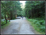 Leaving Parking Lot |
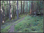 Mossy Trail |
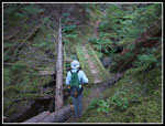 Very Old Bridge |
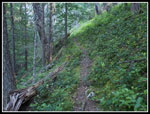 Narrow Trail |
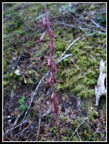 Coralroot |
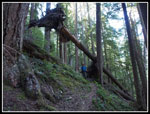 Hanging Tree |
 Pinedrops |
 Pinedrops Closer Up |
 Bright Coralroot |
 Candystick |
 What Underbrush? |
 Yellow Birdsnest |
 More Bare Ground |
 Tiger Lilies |
 Meadows |
 First Views |
 Green Mountain |
 Whitechuck & Whitehorse |
 First Glacier Peak View |
 View North |
 View Northwest |
 All Meadows |
 Lookout Site Ahead |
 John & Glacier Peak |
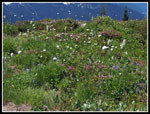 Lots Of Flowers |
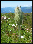 Western Anemone |
 Sulphur & Glacier Pks |
 False Summit |
 Gary On Top |
 Dome Peak |
 Sulphur Lake |
 Heather & Glacier Peak |
 Sulphur Peak Summit |
 More Flowers |
 Close Up Blooms |
 More Heather |
 Steep Drop |
 Western Anemones |
 Glacier Lily |
 Gary At Work |
 John & Gary |
 Clouds Enveloped Summit |
 Suiattle River Valley |
 Circle Of Light |
 Forced Detour |
 Mossy Trail Again |
 Another Candystick |
 Suiattle River |
 Panorama View From The Old Lookout Site Atop Sulphur Mountain |
Trips - 2017
Home