5-04-19
After
a spectacular wildflower hike the weekend before to Sage Hills I chose
another wildflower hike east of the Cascade Crest. I had done the
Westberg Trail two times previously. The first
time was in early April 2014.
The second
was at the end of April 2017. This would be the latest visit and I
hoped for more wildflowers in bloom. I was on the road by 6:35 am
heading east. Over Snoqualmie Pass and beyond Cle Elum to exit 101 for
Thorp. Right turn then a left on Cove Road at 1.9 miles. Follow it to
the end. I arrived to find the parking area was nearly full at 8:20 am.
There was a large group with green WTA hard hats. I picked a day when
they would be working on the trail. While I took the next to last spot
there were several more beyond the WTA folks. I packed up and headed
out ahead of them. It was 110 miles from North Seattle to the 1880'
trailhead. It was sunny but still cool. By 8:24 am I was on my way.
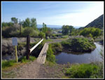
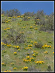
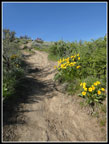
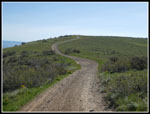
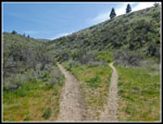
I walked to the end of the road, crossed the bridge over the canal and started heading uphill. This trail has no switchbacks. It is straight up the fall line. I found out the WTA work party was building a new section of trail to bypass the worst straight up section. I did not see where the new trail section leaves and returns to the old trail. The wildflower show began immediately and never really ended. It was nowhere near as profuse as at Sage Hills last week. Smaller groups of wildflowers were seen most of the way just not whole fields of them. Still, a very good display.
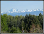
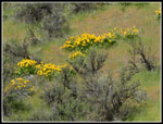
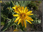
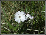
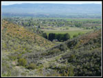
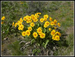
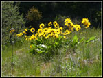
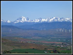
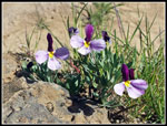
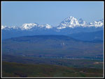
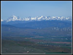
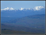
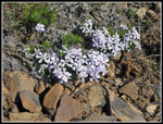
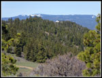
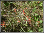
Prairie stars, arrowleaf balsamroot, phlox, desert parsley, and ballhead waterleaf began at once. Most of them were right about at their peak. The low morning sun backlit the balsamroot really lighting it up. I stopped for many photos so I was not all that fast going up. A few folks went on by me and some people were already nearly back down as I ascended. I did not have to gain much elevation until I could look back and see the Stuart Range still coated in bright white snow. That was a fixture of my views on much of the route. Even later in the day the view to the west was very clear. To the east was hazy in the morning and actually clearer as the day went on.
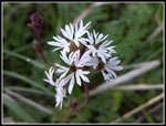
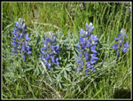
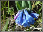
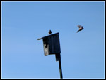
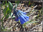
Their are bird houses on posts in places along the ridge of ascent. I could hear birds most of the day. It is only two miles to the memorial viewpoint but it gains about 1640'. Other than a few big old ponderosa pines on the ridge there is virtually no shade. Another reason I do this trip early in the year. The high was forecast to be only about 67 degrees but it ended up being about 10 degrees warmer. That was not a problem going up. It warmed to short sleeves weather but was not too warm in the morning. High up the trail leaves the ridge and turns west heading for the viewpoint. Here spring beauty appeared. Sagebrush violets, ballhead waterleaf, and arrowleaf balsamroot were thick along here too. I started seeing bluebells too. What was missing was yellow bells. They are a staple of early season desert wildflowers. I saw many on my first two visits here. I have seen almost none on any hike this year.
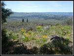
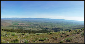
I reached the viewpoint at 9:35 am. 1:11 is not a great time for two miles but with all the photos stops it was not bad either. As mentioned it was a bit hazy to the east. Ellensburg is right below but was hazy. Much clearer to the west. great views of snowy peaks from the Cascade Crest to the end of the Stuart Range. I took a nice break before moving on. At 9:52 am I packed up and headed on. Behind the viewpoint is the road that goes all the way along the ridge top to the observatory. There is a bird house there that had a number of birds perched atop it. I took a number of bird photos before moving on.
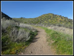
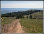
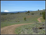
The road varies from fairly smooth to really rocky in some places. Rocky enough to be uncomfortable to walk on with my light trailrunner shoes. For the most part it is fine. The ridge top road has a number of descents and ascents. Almost half the day's elevation gain was in ups and downs along the ridge. There are wildflowers on both sides of the road much of the way to the observatory. Again, not huge patches of colors but individual flowers here and there. From a photography basis it provided many sights to shoot. It just is not those great fields of color.
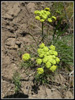
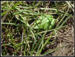
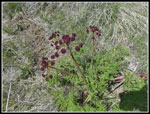
The sagebrush violets, balsamroot, bluebells, and ballhead waterleaf were seen most of the way. There were also a lot of big head clover. These are quite colorful. In the past, I have seen lots of bitterroot leaves though I have always been too early to see the flowers. This time I searched closely and did not see a single bitterroot leaf. Perhaps they are just later this year. It is 3.3 miles from the viewpoint to the observatory. Along the way are views south to Umtanum Ridge and down to Umtanum Valley. To the northwest is the snowy Stuart Range. After the first drop from the Westberg Viewpoint the main road turns sharply left. Another road continues straight ahead. After the turn is a wet spot that had been filled with blooming shooting stars on my first two visits. I was surprised to see not a single sign of them this time. I did see a bright green small from in the grass off the road.
The road then climbs and drops and climbs and drops. At that point you can see the observatory to the right of another bump on the route. The road goes over that bump. The road rounds the last bump and here I heard a big animal running through a patch of forest. I never did see if it was a deer or an elk or whatever. A last drop and a climb up to the observatory. I arrived at 11:18 am. I took 1:18 to hike 3.3 miles from the viewpoint to the observatory. I sat down for lunch with a great view southwest to Mt. Rainier. More west than south. Though I drove east from Seattle I-90 drops farther south than many realize. I was sitting almost exactly east of Olympia. I passed two hikers on my way to the observatory. At lunch two motorcycles and one ATV passed by. That was it. Lots of solitude up on Manastash Ridge.
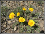
I packed up and headed back at 11:53 am. A 110 mile drive and a 5.3 mile hike, a 35 minute lunch bread, and it was still before noon. As I left I met three women who were just arriving. After dropping down to the first low spot I stopped in a little tree provided shade. I had not had any in a few hours. Here I found the first grass widows of the day. They are one of the early wildflowers and I was disappointed not to see them on the hike in. These ones were right at their peak. A fortuitous find. On the way back I took one detour. An old road headed off to the south to a point looking to the south. It was filled with ponderosa pines. I went over for the views and the shade. Along the way I found a bunch of very deep blue bluebells. Some of the most colorful ones I have seen. It was a good side trip. When I made it back to the road I could hear and see the tree women now behind me on their way back. Voices really carry in the open up high.
I took fewer photos on the return. At 1:29 pm I reached the Westberg Memorial Viewpoint again. Time for another break. As mentioned earlier, it was now less hazy to the east. Ellensburg was quite visible. There was just enough breeze to make it very comfortable. I could have spent the rest of the afternoon there. I could have but I still had a several hour drive home. At 1:51 pm I headed down. When I reached the obvious though unsigned trail junction I turned left. During the hike I debated going back the way I came or taking the Boy Scout Trail. I know of that route but had not taken it before. I did know it was largely in forest. I decided that a new trail with shade trumped going down the seriously steep route I had come up. It turned out great.
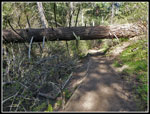
The Boy Scout Trail quickly goes into forest. It is shady with bright green grass for a ground cover. It is a real live dirt trail. Soft and smooth dirt. It is much easier on the knees than the Westberg Trail. I brought hiking poles but never took them off my pack. I did not need them. The forest provided some more wildflowers too. There was a lot of spring beauty and ballhead waterleaf. It one point I noticed some orange color above the trail and went up to find a small patch of some kind of Indian paintbrush. The first I have seen this year. The trail was in fine shape. Some trail work had been done in recent years. Lower down the trail finally left the forest. More views of the Stuart Range. Much to my surprise this open section had a nice display of shooting stars. The upper patch along the road had none this year but the Boy Scout Trail made up for it. They were right at their peak. Near the bottom another trail branches off and climbs. That is the Prater Trail. It goes more directly to the viewpoint. Another reason for me to return and explore.
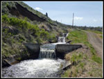
At the bottom the route turns into a road that goes along the canal. In one place there are three man made waterfalls. In short order this brought me back to the start of the Westberg Trail. Now I had just a short road walk back to my car. The WTA work party was just returning. The lot was still mostly full. There are a number of trails to take from this lot for hikers and mountain bikers. I reached my car at 3:00 pm.
This was as fun day. It was quite a bit warmer than expected but nothing like it will be in the summer. There was just enough breeze to make it quite comfortable most of the day. The wildflower display was very good. Well worth the long drive. I had a lot of solitude on the 6.6 miles from the viewpoint to the observatory and back. Two groups of hikers. a couple motorcycles, and a couple ATVs. Even my drive home was not slowed down. On the 2017 trip we had a two hour delay when road paving took I-90 down to one lane. No problems this day. I expect in a few years I will be back for another spring wildflower day on the Westberg Trail.
Click on thumbnails to get
larger pictures.
Trips - 2019
Home
I walked to the end of the road, crossed the bridge over the canal and started heading uphill. This trail has no switchbacks. It is straight up the fall line. I found out the WTA work party was building a new section of trail to bypass the worst straight up section. I did not see where the new trail section leaves and returns to the old trail. The wildflower show began immediately and never really ended. It was nowhere near as profuse as at Sage Hills last week. Smaller groups of wildflowers were seen most of the way just not whole fields of them. Still, a very good display.
Prairie stars, arrowleaf balsamroot, phlox, desert parsley, and ballhead waterleaf began at once. Most of them were right about at their peak. The low morning sun backlit the balsamroot really lighting it up. I stopped for many photos so I was not all that fast going up. A few folks went on by me and some people were already nearly back down as I ascended. I did not have to gain much elevation until I could look back and see the Stuart Range still coated in bright white snow. That was a fixture of my views on much of the route. Even later in the day the view to the west was very clear. To the east was hazy in the morning and actually clearer as the day went on.
Their are bird houses on posts in places along the ridge of ascent. I could hear birds most of the day. It is only two miles to the memorial viewpoint but it gains about 1640'. Other than a few big old ponderosa pines on the ridge there is virtually no shade. Another reason I do this trip early in the year. The high was forecast to be only about 67 degrees but it ended up being about 10 degrees warmer. That was not a problem going up. It warmed to short sleeves weather but was not too warm in the morning. High up the trail leaves the ridge and turns west heading for the viewpoint. Here spring beauty appeared. Sagebrush violets, ballhead waterleaf, and arrowleaf balsamroot were thick along here too. I started seeing bluebells too. What was missing was yellow bells. They are a staple of early season desert wildflowers. I saw many on my first two visits here. I have seen almost none on any hike this year.
I reached the viewpoint at 9:35 am. 1:11 is not a great time for two miles but with all the photos stops it was not bad either. As mentioned it was a bit hazy to the east. Ellensburg is right below but was hazy. Much clearer to the west. great views of snowy peaks from the Cascade Crest to the end of the Stuart Range. I took a nice break before moving on. At 9:52 am I packed up and headed on. Behind the viewpoint is the road that goes all the way along the ridge top to the observatory. There is a bird house there that had a number of birds perched atop it. I took a number of bird photos before moving on.
The road varies from fairly smooth to really rocky in some places. Rocky enough to be uncomfortable to walk on with my light trailrunner shoes. For the most part it is fine. The ridge top road has a number of descents and ascents. Almost half the day's elevation gain was in ups and downs along the ridge. There are wildflowers on both sides of the road much of the way to the observatory. Again, not huge patches of colors but individual flowers here and there. From a photography basis it provided many sights to shoot. It just is not those great fields of color.
The sagebrush violets, balsamroot, bluebells, and ballhead waterleaf were seen most of the way. There were also a lot of big head clover. These are quite colorful. In the past, I have seen lots of bitterroot leaves though I have always been too early to see the flowers. This time I searched closely and did not see a single bitterroot leaf. Perhaps they are just later this year. It is 3.3 miles from the viewpoint to the observatory. Along the way are views south to Umtanum Ridge and down to Umtanum Valley. To the northwest is the snowy Stuart Range. After the first drop from the Westberg Viewpoint the main road turns sharply left. Another road continues straight ahead. After the turn is a wet spot that had been filled with blooming shooting stars on my first two visits. I was surprised to see not a single sign of them this time. I did see a bright green small from in the grass off the road.
The road then climbs and drops and climbs and drops. At that point you can see the observatory to the right of another bump on the route. The road goes over that bump. The road rounds the last bump and here I heard a big animal running through a patch of forest. I never did see if it was a deer or an elk or whatever. A last drop and a climb up to the observatory. I arrived at 11:18 am. I took 1:18 to hike 3.3 miles from the viewpoint to the observatory. I sat down for lunch with a great view southwest to Mt. Rainier. More west than south. Though I drove east from Seattle I-90 drops farther south than many realize. I was sitting almost exactly east of Olympia. I passed two hikers on my way to the observatory. At lunch two motorcycles and one ATV passed by. That was it. Lots of solitude up on Manastash Ridge.
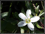
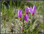
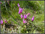
I packed up and headed back at 11:53 am. A 110 mile drive and a 5.3 mile hike, a 35 minute lunch bread, and it was still before noon. As I left I met three women who were just arriving. After dropping down to the first low spot I stopped in a little tree provided shade. I had not had any in a few hours. Here I found the first grass widows of the day. They are one of the early wildflowers and I was disappointed not to see them on the hike in. These ones were right at their peak. A fortuitous find. On the way back I took one detour. An old road headed off to the south to a point looking to the south. It was filled with ponderosa pines. I went over for the views and the shade. Along the way I found a bunch of very deep blue bluebells. Some of the most colorful ones I have seen. It was a good side trip. When I made it back to the road I could hear and see the tree women now behind me on their way back. Voices really carry in the open up high.
I took fewer photos on the return. At 1:29 pm I reached the Westberg Memorial Viewpoint again. Time for another break. As mentioned earlier, it was now less hazy to the east. Ellensburg was quite visible. There was just enough breeze to make it very comfortable. I could have spent the rest of the afternoon there. I could have but I still had a several hour drive home. At 1:51 pm I headed down. When I reached the obvious though unsigned trail junction I turned left. During the hike I debated going back the way I came or taking the Boy Scout Trail. I know of that route but had not taken it before. I did know it was largely in forest. I decided that a new trail with shade trumped going down the seriously steep route I had come up. It turned out great.
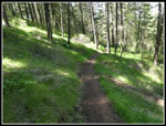
The Boy Scout Trail quickly goes into forest. It is shady with bright green grass for a ground cover. It is a real live dirt trail. Soft and smooth dirt. It is much easier on the knees than the Westberg Trail. I brought hiking poles but never took them off my pack. I did not need them. The forest provided some more wildflowers too. There was a lot of spring beauty and ballhead waterleaf. It one point I noticed some orange color above the trail and went up to find a small patch of some kind of Indian paintbrush. The first I have seen this year. The trail was in fine shape. Some trail work had been done in recent years. Lower down the trail finally left the forest. More views of the Stuart Range. Much to my surprise this open section had a nice display of shooting stars. The upper patch along the road had none this year but the Boy Scout Trail made up for it. They were right at their peak. Near the bottom another trail branches off and climbs. That is the Prater Trail. It goes more directly to the viewpoint. Another reason for me to return and explore.
At the bottom the route turns into a road that goes along the canal. In one place there are three man made waterfalls. In short order this brought me back to the start of the Westberg Trail. Now I had just a short road walk back to my car. The WTA work party was just returning. The lot was still mostly full. There are a number of trails to take from this lot for hikers and mountain bikers. I reached my car at 3:00 pm.
This was as fun day. It was quite a bit warmer than expected but nothing like it will be in the summer. There was just enough breeze to make it quite comfortable most of the day. The wildflower display was very good. Well worth the long drive. I had a lot of solitude on the 6.6 miles from the viewpoint to the observatory and back. Two groups of hikers. a couple motorcycles, and a couple ATVs. Even my drive home was not slowed down. On the 2017 trip we had a two hour delay when road paving took I-90 down to one lane. No problems this day. I expect in a few years I will be back for another spring wildflower day on the Westberg Trail.
 Bridge Over Canal |
 Starting Up |
 First Look At Stuart |
 First Balsamroot |
 Balsamroot Close Up |
 Prairie Stars |
 Balsamroot Hillside |
 Desert Parsley |
 Tiny Phlox |
 Looking Back |
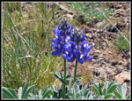
 Lupine |
 Balsamroot Bouquet |
 Backlit |
 Steep Trail |
 Stuart Range & Valley |
 Spring Beauty |
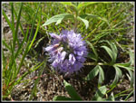
 Sagebrush Violets |
 Bluebells |
 Lemah Mountain |
 Ingalls & Stuart |
 View Northwest |
 Mt. Stuart |
 Hawkins Mountain |
 Birds In A Tree |
 Taking Flight |
 Big Head Clover |
 On The Road Again |
 Frog |
 Look Back To Viewpoint |
 More Phlox |
 Observatory In Sight |
 Observatory & Rainier |
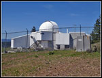 UW Observatory |
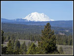 Lunch View Of Rainier |
 First Grass Widows |
 Another Grass Widow |
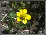 Buttercup |
 More Sagebrush Violets |
 Very Bluebells |
 Detour Viewpoint |
 Fernleaf Desert Parsley |
 Hooker's Balsamroot |
 More Lupine |
 Ballhead Waterleaf |
 Green Boy Scout Trail |
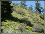 Hillside Balsamroot |
 Indian Paintbrush |
 Big Tree |
 Shooting Stars |
 More Shooting Stars |
 Prater Trail Junction |
 Canal Waterfalls |
 Westberg Viewpoint Panorama |
Trips - 2019
Home