06-04-23
Kim
joined me ford a hike on
Sunday. We planned a trip to the newly opened Suiattle River Trail
but changed our minds. Instead, we headed for the North Cascades and
the Diablo Lake Trail. Kim and I hiked this trail in 2017.
I returned with Gary in 2022.
It is a long drive but we are also nearing the longest day of the year.
We were on the road at 7:05 am. We turned off Highway 20 and crossed
the top of the Diablo Dam, reaching the trailhead at 9:50 am after
several stops on the way. It was a sunny day and a cool morning. We
packed up and were on the trail at 10:01 am. Next to the trailhead
parking lot is the North Cascades Environmental Learning Center. The
trail has to weave its way around it. It goes up and down and crosses a
road. By the road the buildings are right there. Soon the route turns
into a forest walk. There are several signed junctions to get through
the first part of the trip.
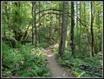
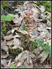
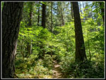
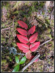
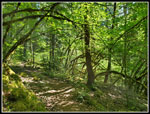
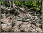
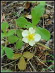
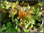
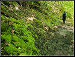
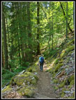
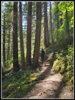
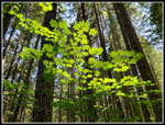
Last year I rock hopped the first creek and fell in. This time I was much more careful. There were not a lot of wildflowers seen on the trail. We did see a few buttercups first and Kim noticed a coralroot saprophyte. The morning sun flickered through the trees. We were constantly seeing lit up leaves. I took photos of them much of the day. The first half of the hike is a steady ascent and the second part is a steady descent. The trailhead is at 1224' and the ending across the suspension bridge at the base of Ross Dam is at 1243'. We hiked 4 miles for a net gain of 19'. The trail is in pretty good shape mostly. On the initial climb it crosses through several rock slides. The footing is okay but it is rocky. After than the tread is fine.
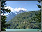
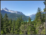
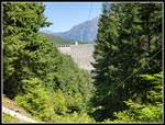
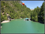
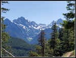
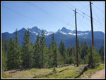
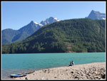
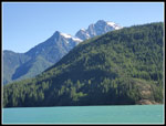
We had all day and were hiking at a slow pace with photo stops. I expected that many hikers would pass us. That was not the case. At about 1.85 miles we reached the viewpoint. The short trail to the right is unsigned. This is where powerlines from the dam cross over the trail. The view is really good except for the powerlines in most photos. A little bit of Diablo Dam can be seen off to the right. Right in front of us were Colonial, Pinnacle, and Pyramid Peaks plus Paul Bunyan's Stump. They had plenty of snow on them. This is a mostly forested walk from the bottom of the valley to the bottom of the valley with a highpoint in the middle. That is the place for the best views. We took a short break here before moving on.
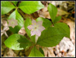
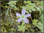
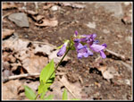
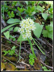
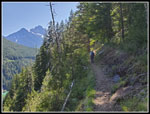
It is mostly downhill the rest of the way. Gently at first and then more steeply. We saw a few hikers ass we continued on. The trail becomes much narrower and on a very steep hillside. We had to find spots to step off so others could pass by. The second half of this hike is a calypso orchid spectacular earlier in the year. Last year we saw many hundreds of them. This year one a single one. We did see Indian paintbrush, death camas, and a few lupines in bloom. There were some other small flowers in bloom. One type looked like a spring beauty on a long thin stalk. We saw a whole lot of those. We left the viewpoint at 11:37 am. It was warming up fast. At one narrow spot on the trail we saw a group coming up behind us. Another group was in front of us. We waited for both groups to pass us. It was right where we were. I looked ahead and there was another group coming. I looked back and there was yet another group coming. Then another group. All together, 15 people went by us as we waited in that spot. That was about 75% of all the people we saw on our hike in. On the positive side, we had almost total solitude except for that one spot.
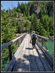
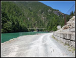
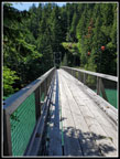
We crossed an open section that was getting pretty hot. After that, we headed back into the forest. That really cooled us down. There were two streams running on our way down. The trail down the last mile is steeper but very smooth. It was pleasant hiking. We reached the final switchback and then the suspension bridge. It is an impressive trail bridge. Diablo Dam is right above. On the other side of the bridge is grass and shade. Just what we were looking for. A big group passed us on the bridge heading back. There were only two people at the grassy field. We arrived at 1:06 pm. We took 3:05 to hike in the four miles.
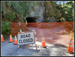
A trip report a month earlier mentioned that the tunnel on the road up to the top of Ross Dam was closed. A note at the trailhead also mentioned it. I took a short walk over to the tunnel to take a look. It was indeed blocked. Something about some rocks falling from the ceiling. I don't know when it will be repaired and reopened. The ferry from near the trailhead docked on the other side of the tunnel. For now, it seems to be docking at the low point in the road before the tunnel. I also saw two hikers who were pumping up inflatable paddle boards. It was pretty windy but they planned to paddle back to the trailhead. At the end of our hike I saw the paddle boards on the rocky beach by the parking lot.
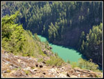
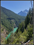
It was really nice laying on the grass in the shade with a breeze and nothing but blue sky. We were in no hurry to head back. We still had the hike back plus a 2.5-3+ hour drive home so we planned to leave at 2:15 pm. Well, we did cross the bridge at 2:30 pm. There was a sign saying that the ferry would be back at 2:30 pm. I stood on the bridge for a few minutes to see if it would arrive before we left. There were a couple groups waiting for it. We did not see it. The first steep mile is not fun after a long break on a hot day. The forest did keep the sun off of us much of the way. We passed a couple more groups coming in. We took a lot fewer photos on the hike back. One of the neatest sections is before the viewpoint when the trail crosses the steep hillside and the looks down at the bright green fjord some 750' straight down.
We stopped at the viewpoint. I went out into the sun for some mountain photos and then went back into the forest. We took a final break in the shade. Now it was almost all downhill back to the car. Other than the rocky washout spots it was easy hiking. We arrived back at the trailhead at 5:09 pm. We took about 2:35 to hike back. Our drive home was wide open. None of the usual backups. I was home about 13+ hours after I left. That made for a whole day trip.
This was a fun trip. I don't get up to the North Cascades Highway often for hikes. It was nice to start the summer with one. We did not have the flower show that occurred in early May. We did have a lot more solitude than I was expecting. It was nice for most of the hikers to pass us at one time. The afternoon was a bit warmer than I prefer but with much of the way in forest it was fine. There is a view point with snowy peaks in sight but this is really a forest walk. The views are all around you not far away. This has become a favorite late spring hike and one I expect to do on a regular basis.
Click on thumbnails to get
larger pictures.
Trips - 2023
Home
Last year I rock hopped the first creek and fell in. This time I was much more careful. There were not a lot of wildflowers seen on the trail. We did see a few buttercups first and Kim noticed a coralroot saprophyte. The morning sun flickered through the trees. We were constantly seeing lit up leaves. I took photos of them much of the day. The first half of the hike is a steady ascent and the second part is a steady descent. The trailhead is at 1224' and the ending across the suspension bridge at the base of Ross Dam is at 1243'. We hiked 4 miles for a net gain of 19'. The trail is in pretty good shape mostly. On the initial climb it crosses through several rock slides. The footing is okay but it is rocky. After than the tread is fine.
We had all day and were hiking at a slow pace with photo stops. I expected that many hikers would pass us. That was not the case. At about 1.85 miles we reached the viewpoint. The short trail to the right is unsigned. This is where powerlines from the dam cross over the trail. The view is really good except for the powerlines in most photos. A little bit of Diablo Dam can be seen off to the right. Right in front of us were Colonial, Pinnacle, and Pyramid Peaks plus Paul Bunyan's Stump. They had plenty of snow on them. This is a mostly forested walk from the bottom of the valley to the bottom of the valley with a highpoint in the middle. That is the place for the best views. We took a short break here before moving on.
It is mostly downhill the rest of the way. Gently at first and then more steeply. We saw a few hikers ass we continued on. The trail becomes much narrower and on a very steep hillside. We had to find spots to step off so others could pass by. The second half of this hike is a calypso orchid spectacular earlier in the year. Last year we saw many hundreds of them. This year one a single one. We did see Indian paintbrush, death camas, and a few lupines in bloom. There were some other small flowers in bloom. One type looked like a spring beauty on a long thin stalk. We saw a whole lot of those. We left the viewpoint at 11:37 am. It was warming up fast. At one narrow spot on the trail we saw a group coming up behind us. Another group was in front of us. We waited for both groups to pass us. It was right where we were. I looked ahead and there was another group coming. I looked back and there was yet another group coming. Then another group. All together, 15 people went by us as we waited in that spot. That was about 75% of all the people we saw on our hike in. On the positive side, we had almost total solitude except for that one spot.
We crossed an open section that was getting pretty hot. After that, we headed back into the forest. That really cooled us down. There were two streams running on our way down. The trail down the last mile is steeper but very smooth. It was pleasant hiking. We reached the final switchback and then the suspension bridge. It is an impressive trail bridge. Diablo Dam is right above. On the other side of the bridge is grass and shade. Just what we were looking for. A big group passed us on the bridge heading back. There were only two people at the grassy field. We arrived at 1:06 pm. We took 3:05 to hike in the four miles.
A trip report a month earlier mentioned that the tunnel on the road up to the top of Ross Dam was closed. A note at the trailhead also mentioned it. I took a short walk over to the tunnel to take a look. It was indeed blocked. Something about some rocks falling from the ceiling. I don't know when it will be repaired and reopened. The ferry from near the trailhead docked on the other side of the tunnel. For now, it seems to be docking at the low point in the road before the tunnel. I also saw two hikers who were pumping up inflatable paddle boards. It was pretty windy but they planned to paddle back to the trailhead. At the end of our hike I saw the paddle boards on the rocky beach by the parking lot.
It was really nice laying on the grass in the shade with a breeze and nothing but blue sky. We were in no hurry to head back. We still had the hike back plus a 2.5-3+ hour drive home so we planned to leave at 2:15 pm. Well, we did cross the bridge at 2:30 pm. There was a sign saying that the ferry would be back at 2:30 pm. I stood on the bridge for a few minutes to see if it would arrive before we left. There were a couple groups waiting for it. We did not see it. The first steep mile is not fun after a long break on a hot day. The forest did keep the sun off of us much of the way. We passed a couple more groups coming in. We took a lot fewer photos on the hike back. One of the neatest sections is before the viewpoint when the trail crosses the steep hillside and the looks down at the bright green fjord some 750' straight down.
We stopped at the viewpoint. I went out into the sun for some mountain photos and then went back into the forest. We took a final break in the shade. Now it was almost all downhill back to the car. Other than the rocky washout spots it was easy hiking. We arrived back at the trailhead at 5:09 pm. We took about 2:35 to hike back. Our drive home was wide open. None of the usual backups. I was home about 13+ hours after I left. That made for a whole day trip.
This was a fun trip. I don't get up to the North Cascades Highway often for hikes. It was nice to start the summer with one. We did not have the flower show that occurred in early May. We did have a lot more solitude than I was expecting. It was nice for most of the hikers to pass us at one time. The afternoon was a bit warmer than I prefer but with much of the way in forest it was fine. There is a view point with snowy peaks in sight but this is really a forest walk. The views are all around you not far away. This has become a favorite late spring hike and one I expect to do on a regular basis.
 Trailhead View |
 Arch Over Trail |
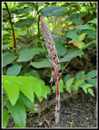
 Coralroot |
 Lit Up Leaves |
 Red Leaves |
 More Bright Leaves |
 Rocky Trail |
 Flower Shadow |
 Mountain Viewpoint |
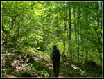 Kim Leads The Way |
 Diablo Lake |
 Spring Beauty Like |
 Stonecrop |
 Strawberry |
 Penstemon |
 Indian Paintbrush |
 Death Camas |
 Deep Green Gorge |
 Ross Dam |
 Very Green Moss |
 Descending |
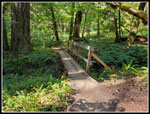
 Crossing Bridge |
 View From Bridge |
 Tunnel Is Closed |
 Bridge From Road |
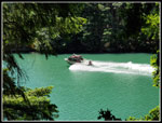 Speeding Boat |
 Heading Back |
 Shady Forest Ascent |
 More Lit Up Leaves |
 Peaks In View |
 Bright Green Lake |
 Kim On Trail |
 Back At Viewpoint |
 Another Bridge |
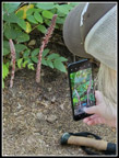 Kim At Work |
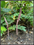 Two Candy Sticks |
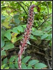 Really Colorful |
 Rarely Seen |
 Back At Start |
 Lake & Colonial Peak |
Trips - 2023
Home