07/29-08/01/23
At
the start of the week Gary put
out a plan to John and I for a four day backpacking trip. Our schedules
were not all free until Saturday. Gary's plan was a return to a trip we
had all done before. Gary and I day hiked Pilot Ridge in 1993. In 2003
we did the loop for the first time. In 2012 John joined us for a return
to the loop. That time we added a loop of Foam Basin and Red Pass from
White Pass. Now it was the 30th anniversary of our Pilot ridge trip,
the 20th anniversary of our first loop, and the 11th
anniversary
of our first dual loop trip. We planned a repeat of the 2012 trip with
a few possible changes. 30 years ago we were much younger and faster.
The same for 20 and 11 years ago. This would be a tough trip with about
5000' of gain on the first day with full four day backpacks.
Day 1
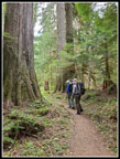
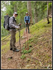
We met at my house in North Seattle at 6:30 and soon headed north. It was my turn to drive. We saw reports from a week earlier mentioning the terrible bugs. Bug head nets and deet were packed. The Mountain Loop Highway was closed until two weeks earlier by a landslide. We chose to go the shorter way via Barlow Pass that took us through the repaired area near Elliott Creek. Traffic was great and we were at Barlow Pass on target for a two hour drive. The MLH is not in top shape. There are lots of pot holes. That slowed us down. We turned onto the road to the NF Sauk Trailhead and it became much worse. The plot holes were big and they were all the way across the road in many places. We slowed way down. I had plenty of ground clearance for the bad spots but it was just really slow. It was like 6.8 miles of the old MF Snoqualmie Road. We arrived at the trailhead at about 9:00 am. The lot was nearly full but we squeezed into a spot.
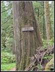
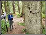
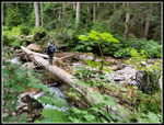
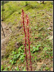
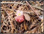
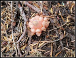
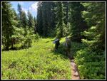
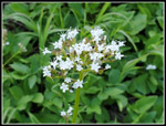
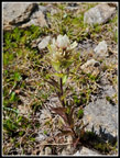
By 9:11 am we were on our way. The NF Sauk Trail has big trees. I would fully appreciate it on the way out. In the first couple miles to the Pilot Ridge trail junction we saw big trees and big skunk cabbage leaves. The trail leads down to the river and this year there is a big log across with a flattened top. We had no problem getting across. After a quick break it was time to start climbing. The trial climbs relentlessly. The grade is pretty steady but steep. With around 5000' of gain on day 1 we knew it would be challenging. It was not hot but it was humid. Not my favorite conditions. On the way up we saw a variety of saprophytes. Just a few old coralroot. Pinedrops were more often seen. Some were several feet tall. We also saw a couple gnome plants. I have only seen them a few times, including last year. At about 3600' we crossed the one creek where we expected water. It was time to drink water and pump to refill our containers. We did not expect to find much if any water higher up.
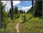
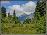
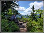
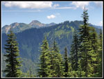
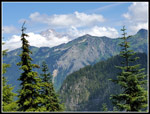
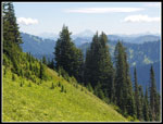
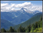
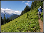
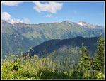
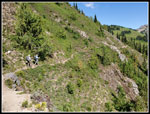
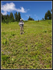
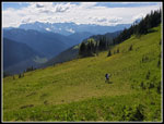
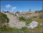
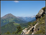
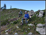
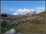
As we climbed higher the grade began to ease. We moved from forest to forest and meadows. We had a group pass us going down. That would be the pattern for the trip. There were quite a few groups doing the loop but they all seemed to be doing it clockwise vs. our counterclockwise. At a high point in a meadow we took our lunch break. It was already about 1:10 pm. The break was nice and we were soon heading downhill. From there to camp the route was up and downhill. We were often on the ridge top and sometimes on the left side. In only one or two places were we on the left side of the ridge. On the right side we began to have some views out to the Monte Cristo Peaks and to Sloan Peak. This was among the best views of those peaks although the afternoon sun was not as clear as in the morning. There were also clouds near the peaks. The steep climbs were getting tougher. It was warmer and still very humid. I had salt running into my eyes continuously. Our packs were at full weight and we were well past 4000' gained.
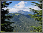
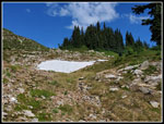
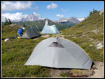
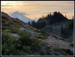
I felt better when Johnson Mountain came into view. Most folks plush on to Blue Lakes for sure water. We had that as a backup but hoped to find water near the ridge top where we had in 2003 and 2012. At the right spot we left the trail for the last steep open slope climb to the ridge top. John was doing well but Gary and I were dragging a bit. Just below the ridge top we found a good sized snow bank with water running out of it. Just what we had hoped to find. We went up to the ridge top then down to the small basin where we would camp. In early September 2012 we found a large snowbank on the north side of the ridge. This time a smaller bank was on the south side. There was no water on the north side. The snow we found will likely be melted within the next couple weeks. We set up camp. The idea is to have Glacier Peak right out your tent door. Glacier was now partly lost in the mounting clouds. The clouds soon grew thicker. We did have a very good view of Indian Head Peak.
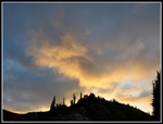
We headed across the ridge for water and to have dinner. It was windy but a small campsite provided a wind break for cooking. It was in shade and we moved back into the sunshine to eat. My canister stove that worked flawlessly four weeks earlier did not work. The gas lit then immediately went out. The rush of gas did not change. A mystery. John had a stove for himself and I used my canister with his stove for Gary and I. When I was at home it worked perfectly once again. After dinnerWe , we headed back to camp. Our last short jaunt was to climb up about 100' to the higher point just above camp. At the top I had a solid phone and Internet signal. That was a surprise. We were not alone. We saw a spotting scope at a slightly higher saddle to the west. A tent was down below it. We did later see the tent owner. It was strange to see another person camping near the ridge top. We stayed out of our tents until almost sunset as the clouds kept building and the wind kept blowing. We had bad condensation at this spot before. We hoped it would not be a problem this time. At 8:48 pm I was the last one to head to bed. For the day we hiked about 9 miles with about 5100' of elevation gain. I had no trouble falling asleep. After the steep climb up to the high country we would have two more days largely above 6000'.
Click on thumbnails to get
larger pictures.
Day 2
Trips - 2023
Home
Day 1
We met at my house in North Seattle at 6:30 and soon headed north. It was my turn to drive. We saw reports from a week earlier mentioning the terrible bugs. Bug head nets and deet were packed. The Mountain Loop Highway was closed until two weeks earlier by a landslide. We chose to go the shorter way via Barlow Pass that took us through the repaired area near Elliott Creek. Traffic was great and we were at Barlow Pass on target for a two hour drive. The MLH is not in top shape. There are lots of pot holes. That slowed us down. We turned onto the road to the NF Sauk Trailhead and it became much worse. The plot holes were big and they were all the way across the road in many places. We slowed way down. I had plenty of ground clearance for the bad spots but it was just really slow. It was like 6.8 miles of the old MF Snoqualmie Road. We arrived at the trailhead at about 9:00 am. The lot was nearly full but we squeezed into a spot.
By 9:11 am we were on our way. The NF Sauk Trail has big trees. I would fully appreciate it on the way out. In the first couple miles to the Pilot Ridge trail junction we saw big trees and big skunk cabbage leaves. The trail leads down to the river and this year there is a big log across with a flattened top. We had no problem getting across. After a quick break it was time to start climbing. The trial climbs relentlessly. The grade is pretty steady but steep. With around 5000' of gain on day 1 we knew it would be challenging. It was not hot but it was humid. Not my favorite conditions. On the way up we saw a variety of saprophytes. Just a few old coralroot. Pinedrops were more often seen. Some were several feet tall. We also saw a couple gnome plants. I have only seen them a few times, including last year. At about 3600' we crossed the one creek where we expected water. It was time to drink water and pump to refill our containers. We did not expect to find much if any water higher up.
As we climbed higher the grade began to ease. We moved from forest to forest and meadows. We had a group pass us going down. That would be the pattern for the trip. There were quite a few groups doing the loop but they all seemed to be doing it clockwise vs. our counterclockwise. At a high point in a meadow we took our lunch break. It was already about 1:10 pm. The break was nice and we were soon heading downhill. From there to camp the route was up and downhill. We were often on the ridge top and sometimes on the left side. In only one or two places were we on the left side of the ridge. On the right side we began to have some views out to the Monte Cristo Peaks and to Sloan Peak. This was among the best views of those peaks although the afternoon sun was not as clear as in the morning. There were also clouds near the peaks. The steep climbs were getting tougher. It was warmer and still very humid. I had salt running into my eyes continuously. Our packs were at full weight and we were well past 4000' gained.
I felt better when Johnson Mountain came into view. Most folks plush on to Blue Lakes for sure water. We had that as a backup but hoped to find water near the ridge top where we had in 2003 and 2012. At the right spot we left the trail for the last steep open slope climb to the ridge top. John was doing well but Gary and I were dragging a bit. Just below the ridge top we found a good sized snow bank with water running out of it. Just what we had hoped to find. We went up to the ridge top then down to the small basin where we would camp. In early September 2012 we found a large snowbank on the north side of the ridge. This time a smaller bank was on the south side. There was no water on the north side. The snow we found will likely be melted within the next couple weeks. We set up camp. The idea is to have Glacier Peak right out your tent door. Glacier was now partly lost in the mounting clouds. The clouds soon grew thicker. We did have a very good view of Indian Head Peak.
We headed across the ridge for water and to have dinner. It was windy but a small campsite provided a wind break for cooking. It was in shade and we moved back into the sunshine to eat. My canister stove that worked flawlessly four weeks earlier did not work. The gas lit then immediately went out. The rush of gas did not change. A mystery. John had a stove for himself and I used my canister with his stove for Gary and I. When I was at home it worked perfectly once again. After dinnerWe , we headed back to camp. Our last short jaunt was to climb up about 100' to the higher point just above camp. At the top I had a solid phone and Internet signal. That was a surprise. We were not alone. We saw a spotting scope at a slightly higher saddle to the west. A tent was down below it. We did later see the tent owner. It was strange to see another person camping near the ridge top. We stayed out of our tents until almost sunset as the clouds kept building and the wind kept blowing. We had bad condensation at this spot before. We hoped it would not be a problem this time. At 8:48 pm I was the last one to head to bed. For the day we hiked about 9 miles with about 5100' of elevation gain. I had no trouble falling asleep. After the steep climb up to the high country we would have two more days largely above 6000'.
 Big Tree |
 GP Wilderness |
 Pilot Ridge Trail |
 Gary Crosses River |
 Big Pinedrop |
 Pinedrop Close Up |
 Gnome Plant? |
 Gnome Plan |
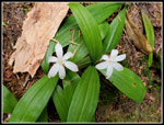 Queen's Cup |
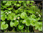 Marsh Marigolds |
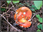 Amanita Mushroom |
 Ridge Top Meadow |
 Nice View |
 John At Lunch |
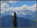 Monte Cristo Peaks |
 Johnson Mt. & Camp |
 Glacier Peak & Clouds |
 More Meadows |
 Mt. Stuart |
 Sloan & Bedal Peaks |
 Sloan Peak & Gary |
 White Mt. & Pass |
 Valerian Close Up |
 Framed Peak |
 Guys On Trail |
 John On Hillside |
 Gary Ascending |
 White Indian Paintbrush |
 Water Supply |
 John On Ridge Top |
 Campsite |
 Indian Head & Mt. David |
 Dinner Time |
 Guys On Ridge Top |
 Near Sunset |
 Sun On Clouds |
Day 2
Trips - 2023
Home